Meteorological Physical Background
Introduction
Cold Fronts generally form within a baroclinic boundary between cold and warm air masses. The main physical process for the development of cold fronts is the movement of the cold air against warm air. The warm air ascends along the boundary while the cold air sinks below it. If there is enough humidity, the upward motion leads to condensation and to the development of clouds and precipitation.
The definition of a cold front in the sub tropics is: "a narrow sloping layer with a vertical extent of at least 3km where the temperature decreases by at least 3 C".
Geographical Location
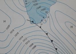
South Africa, located between 25°S and 35°S, lies in subtropics and therefore the descending leg of the Hadley cell. Cold fronts in the sub tropics usually occur from 25°S to 40°S but on a few occasions as far north as 15-20°S. Typically only the tail of cold front moves over South Africa with the Atlantic Ocean High moving behind it from the west and a coastal low about 5° east of the front.
|
Hadley Circulation in the southern hemisphere
|
A typical cold front over South Africa
|

|
|
Seasonal variety
Cold fronts have their largest effect on South Africa weather during the Southern Hemisphere autumn, winter and spring (March to October). Cold fronts are most prevalent and most intense in Austral winter but summer cold fronts are not unknown in South Africa. The effect that cold front have on the weather during summer is much less intense than during autumn, winter and spring.
|
Typical Summer pattern
|
Typical Winter Pattern
|

|

|
Life Cycle
The Norwegian cyclone model, named after the Norwegian meteorologists who first conceptualized the typical life cycle of cyclones in the 1910s and 1920s, presents the evolution of a cyclone.
The image indicates the typical life cycle of a cold front. First there is a boundary, or front, separating warm air to the north from cold air to the south. The front is often stationary but the frontal wave may progress eastwards with time. During the second stage a wave forms on the front as an upper level disturbance embedded in the jet stream moves over the front. The front develops a "kink" where the wave is developing. Precipitation starts to occur, heaviest along the frontal boundary (indicated by the green shading). The third stage happens as the wave intensifies and both cold and warm fronts become better organized. The wave becomes a mature low pressure system in stage 4, while the cold front, moving faster than the warm front, "catches up" with the warm front. In the fifth and final stage the cold front overtakes the warm front, an occluded front forms.
|
Typical Life Cycle of the cold front
|
Typical clouds associated with a mature cold front
|

|

|
Surface weather conditions associated with the passage of a cold front in the sub tropics
South Africa has a unique interior plateau separated from the coast by an escarpment. This escarpment results in air descending this plateau on its way to the coast resulting in cyclonic vorticity. Coastal lows form along the coast of Namibia as a cold front approaches South Africa from the west. The high pressure over the interior dominates the synoptic circulation causing an offshore flow along the Namibian coast leading to the formation of a coastal low. As the front progress eastwards, the coastal low moves to the southwest coast, south coast and east coast and later disappears over the coast of Mozambique.
The Tables below outlines the change in conditions at the surface and vertically with the passage of a cold front over South Africa:
Table 1: Characteristic horizontal changes in surface variables during the passage of a cold front along the south coast of South Africa
|
||
| Surface variables | Pre frontal | Post frontal |
|---|---|---|
| Wind direction | NW | SW |
| Pressure tendency | falling | rising |
| Temperature | warm | cold |
| Dew point | dry | moist |
| Equivalent Potential temperature (Θe) | high | low |
| Cloud | clear becoming stratiform | convective |
Table 2: Characteristic vertical changes (surface and 700 hPa) in atmospheric variables during the passage of a cold front along the south coast of South Africa
|
||
| Variables | Pre frontal | Post frontal |
|---|---|---|
| Wind direction | NW | SW |
| Geopotential | falling | rising |
| Air mass change | Decrease in wet bulb potential temperature of at least 3°C up to 700 hPa | |
| Dry bulb Temperature | Decrease in dry bulb temperature of at least 3°C up to 700 hPa | |
Coastal Lows
Coastal lows are shallow weather systems and are as deep as the escarpment is high. The depth of coastal lows vary but will never extend to pressures lower than 850 hPa (5000 ft above sea level). The leading edge the coastal low is associated with an offshore flow (red arrow on image) which leads to dynamic and adiabatic warming as air descends the escarpment. These hot winds are termed bergwinds in South Africa and is similar to the Foehn wind which occurs in the Alps. The flow is onshore to the rear of the coastal low (blue arrow on image) resulting in cooler temperatures. The transition from an offshore flow causing clear and hot conditions along the coastal belt to onshore flow resulting in cloudy and cooler conditions can very often be mistaken the passage of a cold front.
|
Topography of South Africa
|
Flow associated with a Coastal Low
|

|

|

|
Press "Play Button" to see the loop; Overland Ridging Process. |
|
|
Press "Play Button" to see the loop; Coastal Ridging Process. |
|
|
Press "Play Button" to see the loop; High Ridging south of South Africa. |