Theory
The main characteristic of this case is a Dark Stripe in the satellite water vapour image and is marked by a darker colour than its surroundings (see Water Vapour Dark Stripe ). A Dark Stripe indicates the presence of descending dry air, which can be of stratospheric origin. The stripe develops along the cyclonic side of the white water vapour band. Typical places of appearance of Dark Stripes are the rear of Cold Fronts and Occlusions, and the forward sides of Warm Fronts. This case study will concern a Dark Stripe behind a Cold Front.
There is a strong relationship between a Dark Stripe and potential vorticity. The value 2 PVU (potential vorticity units) of the potential vorticity indicates the tropopause. In the literature, values of 1.5 PVU are mentioned (see potential vorticity). A Dark Stripe, as mentioned here, is a PV-anomaly, at an inclined plane, at the rear of a Cold Front.
|
|
|
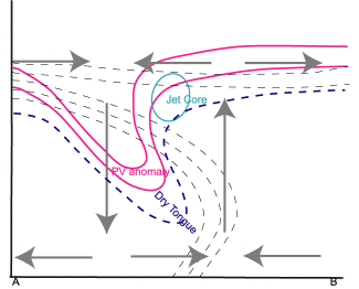
The figure above is a vertical cross section of a Dark Stripe behind a Kata Cold Front. The dashed black lines indicate the isolines of equivalent potential temperature. The lines first bend forward and bend backward at higher levels. This is the classic pattern for a Kata Cold Front.
The red line is potential vorticity with a value of 2 PVU. This line is an indication of the tropopause. High values of potential vorticity drop behind the front plane.
The blue line represents an area of very low relative humidity. Above this line the air is very dry. According to the theory, the position of this extremely dry air is the area where the PV-anomaly is positioned. The jet streak can be found in front of the PV-anomaly and just behind the surface Cold Front.
To the rear of the Cold Front there is cold air, which is related to descent. The descending air mass can be seen at the rear of the PV-anomaly. Ascending air is situated in front of the PV-anomaly.
In order to study the type of Cold Front, two parameters can be used: the thermal front parameter and the zero line of the shear vorticity. The thermal front parameter lies forward of the cloudiness in the case of an Ana Cold Front, and within the cloudiness, to the rear, for a Kata Cold Front. In both cases, the zero line of the shear vorticity can be seen behind the edge of the cloudiness. In the case of an Ana Cold Front it is situated parallel to the clouds; in the case of a Kata Cold Front the zero line lies at an angle to the front.
Of special interest are situations with strong wind fields which are present deep down in the troposphere, this is often the case to the rear of a Cold Front in the dry intrusion of a storm depression (e.g. in the mature stage of Rapid Cyclogenesis). The descending air with high values of PV penetrates into the (potentially) unstable layers in the lower part of the troposphere. PVA in front of the PV-anomalies enhances the convection, the convection could be dry but also moist, resulting in showers. This mechanism causes a strong variation in upward and downward motion near the surface and leads to extremely gusty winds.
