The Synoptic Situation
From October 25 till 28 October 2002, a depression moved from the western part of the Atlantic Ocean towards Europe. On 23 October 2002 the depression had developed on the east coast of the United States. On 26 October the system arrived at the British Isles and on October 27 over the mainland of Western Europe. On October 27 at 12.00 UTC the lowest pressure value in the centre of the system, was 973 hPa. Thereafter, the pressure gradually began to rise. The last day of the sequence was October 28, the depression is now decaying and is located above Northeastern Europe.
The Cold Front belonging to this depression is in cold advection during the period. In the beginning it is an Ana Cold Front. On the 26th of October at 18.00 UTC the first signs of a Kata Cold Front could be seen. On October 27 at 06.00 UTC the front is definitely identified as a Kata Cold Front. By the end, on October 28, the Cold Front seems to switch back to an Ana Cold Front, but the indication for this is very weak.
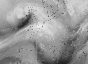
A Dark Stripe in the WV image appears on October 26 at 45°N and 35°E and moves toward Great Britain. At 18.00 UTC the Dark Stripe lies just west of Ireland.
On October 27 at 00.00 UTC the Dark Stripe is located exactly over Ireland. 6 hours later it is situated over Great-Britain and 6 hours later, over the Netherlands. At 18.00 UTC the position of the Dark Stripe is over Poland and Germany. On the last day, October 28th, the Dark Stripe becomes smaller and eventually disappears.
|
27 October 2002/00.00 UTC - Meteosat WV image; 27/00.00 - 28/00.00 UTC 3-hourly image loop
|
|
