Chapter III: Further investigation
Table of Contents
- Chapter III: Further investigation
- Further investigation
Further investigation
The large area of the northern Italy and North Adriatic was undergoing convective activity for more than 12 hours.
Figure 3.1: Lisca Radar vertically integrated liquid in mm loop from 24 September at 18 UTC to 25 September at 5 UTC
Until 22 UTC most of the convective activity took place over the sea. In the night the entire system started moving eastwards and the precipitation maximum moved into the Istrian land. Simultaneously, near the horn of Istria, an enhanced convective development formed within the cloud system and the area of Pula and its surroundings was hit by heavy precipitation.
As explained before, the low-level synoptic conditions were characterized by the south-easterly flow at the front side of a cyclone moving eastwards through the Tyrrhenian Sea, transporting warm and humid air along the eastern Adriatic coast. The formation of the second cyclone caused the strong convergence along the west coast of Istria peninsula.
Figure 3.2: Horizontal wind at 925 hPa forecast by ALADIN/HR model valid from 15 UTC on 24 Sept to 09 UTC on 25 Sept 2010
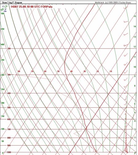
Figure 3.3: Pseudo-sounding by ALADIN/HR model for Pula valid at 00 UTC on 25 September 2010
Besides the strong horizontal convergence, the south components of the flow through the whole atmosphere and a large amount of humidity up to 7 km can be found at pseudo-sounding for Pula.
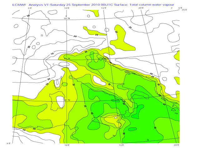
Figure 3.4: ECMWF analysis total precipitable water for 25 September 2010, 00 UTC
The total precipitable water shows values greater than 30 over the coastal areas and greater than 35 over the Adriatic sea indicating the moderate moisture content. Togeteher with high moisture convergence it gives a good possibility for the high amount of precipitation.