Authors
ZAMGJarno Schipper
Ukrainian Hydrometeorological Institute
Alex Kryvobok
Introduction
This case study is about the severe convective development over Ukrain on 9th and 10th July 2004. Severe rainfall and hail were associated to this convective event. In the surface analysis below the synoptic situation for the 9th July can be observed. A depression with its center over the North Sea is seen covering Western Europe. Further East over the Balkan area an anticyclone can be seen that also plays an important role. On the 9th of July the depression over the North Sea rapidly moves eastward and directed by the ridge of high pressure moves into Ukrain. Especially the warm front shield of this system is highly convective and brings large amounts of rain to this area. Then on the 10th July within the cold front convection is triggered along the Carpathian Mountains. With the anticyclone still over Eastern Europe this convection is directed to Ukrain as well bringing large amounts of rain in rather short periods.

|

|
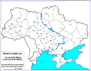
| Surface Analysis: 9th July 2004: 06 UTC | Accumulated Precipitation: 10th July 2004 |
In the map to the right the accumulated precipitation of 10th July is pictured. There were heavy rains during night and day on 10 July over different parts of Ukraine. Heavy rains in the night were particularly witnessed over the Carpathian region (15-31 mm), Kiev and Cherkassy regions (16-48 mm). Heavy rains were also observed over the south part of Ukraine (15-36 mm) during daytime and on the second half of the day large amounts of rain were observed over the Ternopol region:
- in Ternopol, 71 mm, from 16:50 to 18:12 UTC
- Berezhany, 29 mm, from 16:45 to 17:55 UTC
The aim of this case study is to:
- Show the onset of convective event using various Meteosat 8 channels and artificial coloured combinations.
- Study satellite imagery in combination with NWP fields
- Investigation of the dynamic background by considering the basic and derived numerical model parameters
The convection in the warm front shield and also the convection that develops in the thickness ridge of a warm sector are both described in detail in this case study as well as the influence of the diurnal variation of solar radiation. To be able to follow the case study from the beginning it is preferable to study the chapter dealing with convection from the “Manual of Synoptic Satellite Meteorology”.