Cloud Structure In Satellite Images
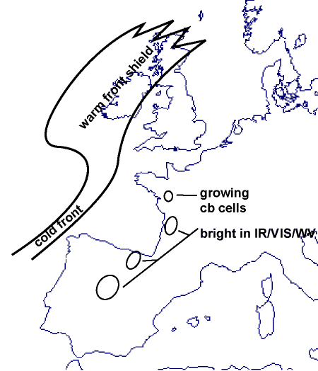
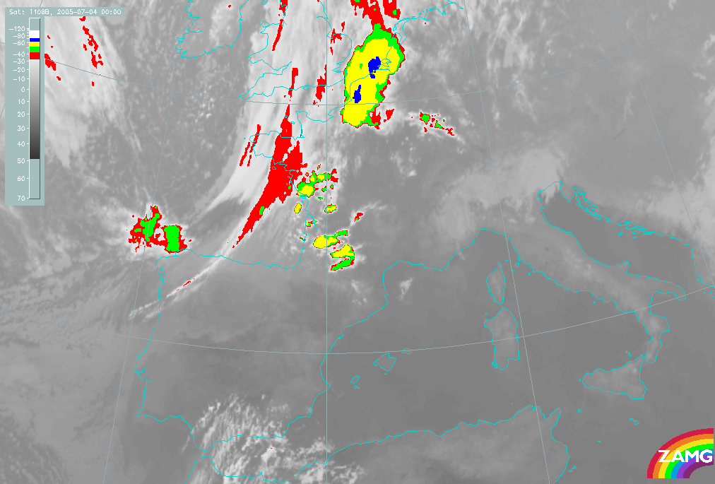
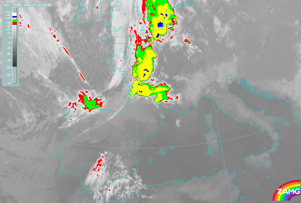
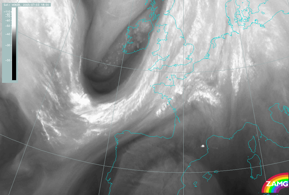
- In satellite images a developing Spanish Plume event is characterized by a south/southwest - north/northeast oriented Cold Front cloud band moving eastwards towards the Iberian Peninsula and Western Europe. As the Cold Front approaches France and the Iberian Peninsula, clusters of Cumulonimbus Clouds (Cb) develop in the mainland. As the clusters grow, they acquire an oval MCS - like appearance with a larger horizontal extent.
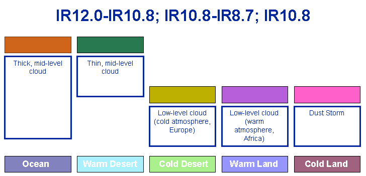
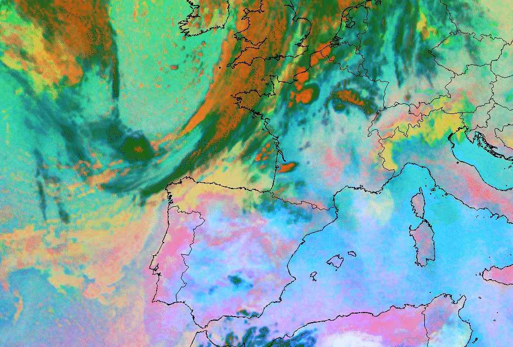
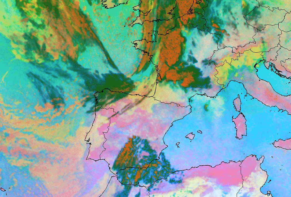
- In IR, WV and VIS images, the Plume is characterized by rapidly brightening cloud pixels, indicating strong vertical development of convective cells, which soon extend through the whole troposphere. In Dust RGB composite imagery (IR12.0-IR10.8; IR10.8-IR8.7; IR10.8) the convective cells are characterized in the beginning by isolated red-orange pixels.
- In the WV images, a smooth grey zone extends from the Spanish plateau in a northerly direction towards France, the Benelux and the British Isles. Within this zone the first signs of developing Cb cells are easy to detect as tiny white spots emerging from the greyer environment.
- The contrast between the clouds and cloud-free area is distinct, especially at the upstream edges of cloud clusters. In the case of strong upper level winds, high level cloudiness is transported downstream leading to an extended white cloud shield (the anvil) in IR but a fibrous grey texture in VIS. The brightest grey shades can be found in the active part upstream. This feature is best recognizable in Dust RGB (IR12.0-IR10.8; IR10.8-IR8.7; IR10.8) imagery, where the cloud clusters, i.e. red-orange areas, are well distinct from the environment. The kelly green or dark blue areas allow the identification of high cloudiness transported by strong upper winds.
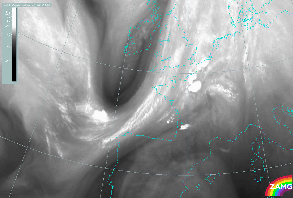
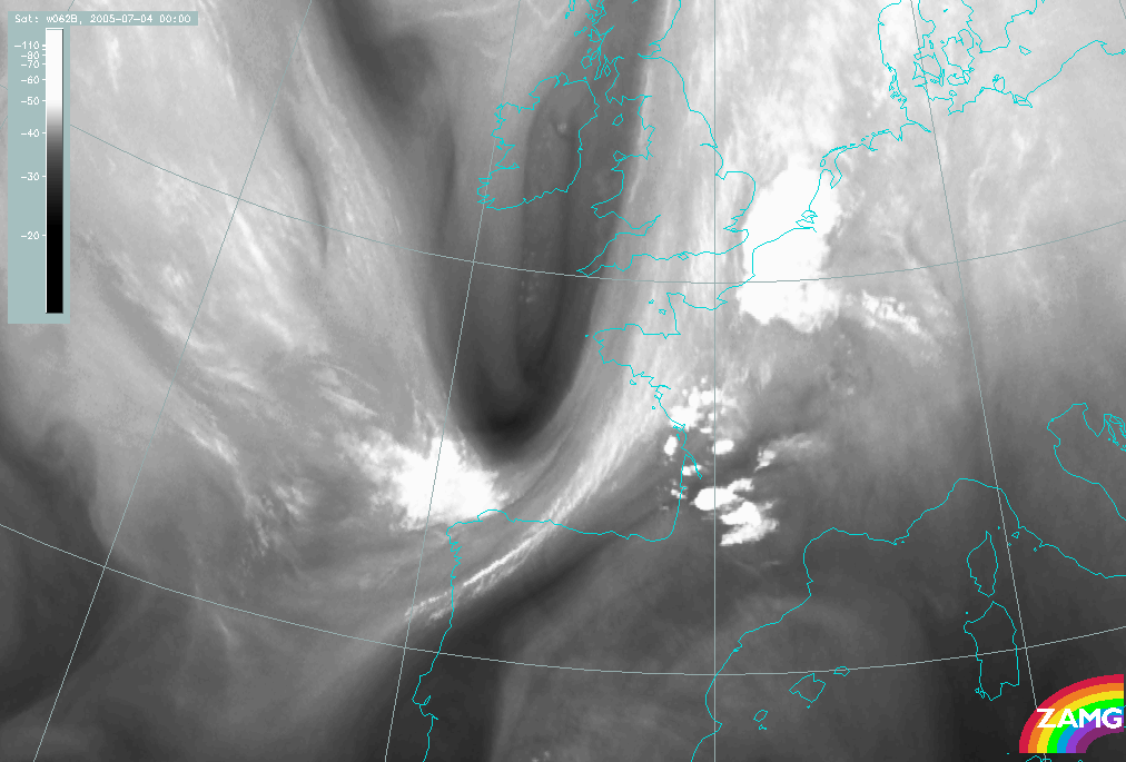
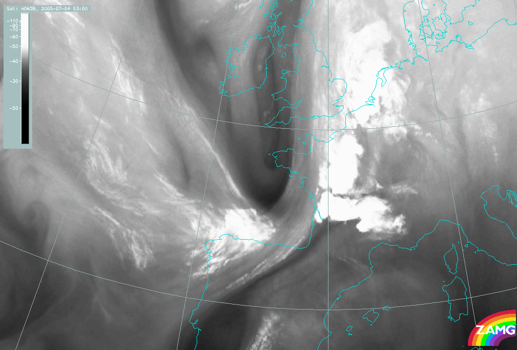
- In the mature and subsequent stages, numerous convective clusters may develop along the "Spanish Plume". This process is extremely pronounced in Dust RGB images (IR12.0-IR10.8; IR10.8-IR8.7; IR10.8), where red-orange isolated pixels rapidly spread into very large red-orange areas. More on the different colors observed in this Dust RGB can be found here .
|
|
|
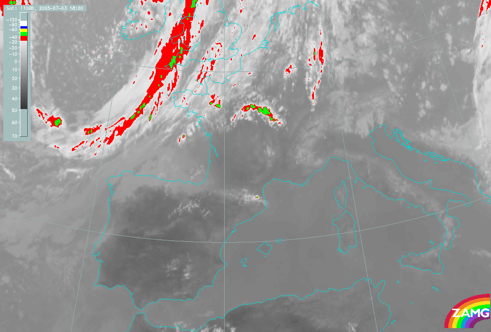
03 July 2005/18.00 UTC - Meteosat 8 IR10.8 enhanced image
|
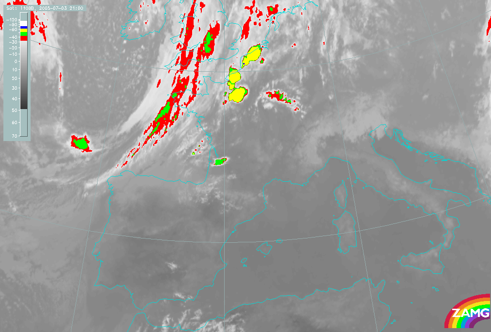
03 July 2005/21.00 UTC - Meteosat 8 IR10.8 enhanced image
|
|
|
|
|
|
04 July 2005/00.00 UTC - Meteosat 8 IR10.8 enhanced image
|
04 July 2005/03.00 UTC - Meteosat 8 IR10.8 enhanced image
|
|
03 July 2005/21.00 UTC - Meteosat 8 Dust RGB image (IR12.0-IR10.8, IR10.8-IR8.7 and IR10.8)
|
04 July 2005/03.00 UTC - Meteosat 8 Dust RGB image (IR12.0-IR10.8, IR10.8- IR8.7 and IR10.8)
|
|
|
In WV imagery the pre-convection environment often shows a moist mid-tropospheric warm conveyor belt extending from the Spanish plateau northwards. The first small-scale convective cells are easily detected in either IR or WV images. The Pyrenees - mountains sometimes cause some Lee Cloudiness, which can partly hide convective development in its earliest stage. The Lee Cloudiness can, however, also be used as an indicator of the existing moist southerly air flow.
The water vapour images below clearly show the Cold Front cloudiness over the northwestern coast of Iberian peninsula, and the broad moist upper-level tropospheric flow known as the "Spanish Plume" lying ahead of it over the Spanish plateau and western parts of continental Europe. Individual Cb cells can be found embedded within this moist zone.
|
03 July 2005/18.00 UTC - Meteosat 8 WV6.2 image
|
03 July 2005/21.00 UTC - Meteosat 8 WV6.2 image
|
|
|
|
|
|
04 July 2005/00.00 UTC - Meteosat 8 WV6.2 image
|
04 July 2005/03.00 UTC - Meteosat 8 WV6.2 image
|
The rapidly growing convective cells often form a long chain. The chain is oriented parallel to the Cold Front, but the distance between the chain and the front may vary. Local topographic forcing also determines the precise location at which the storms will form. Favoured locations for new development seem to be in northern Spain, near the coast of France and in the French Massif, from where the cells move north or northeastwards with the upper level flow.
During the earliest hours of development small-scale convective cells quickly grow both horizontally and vertically. This can be seen as rapid increase in brightness in all channels. Most strikingly, this increase in brightness can be seen in WV images, as the contrast between the individual developing cumulonimbus tops (bright white) and the environment (greyer shades) is well marked.
While the convective cells along the Spanish Plume grow, the Cold Front cloudiness gradually becomes less distinct as can be seen both from IR and WV images. Sometimes a relatively dry upper layer between the Cold Front and the Spanish Plume becoming narrower as the front overtakes the convective plume area may be observed. At later stages the Cold Front cloudiness may either merge with the convective cloudiness or gradually weaken with no interaction.
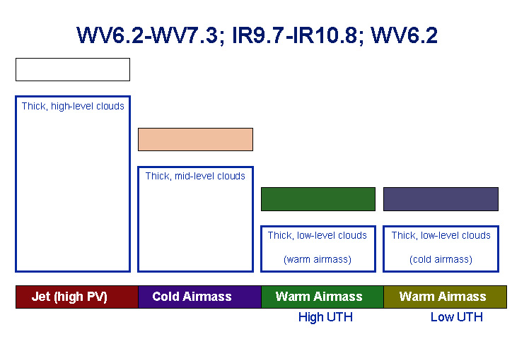
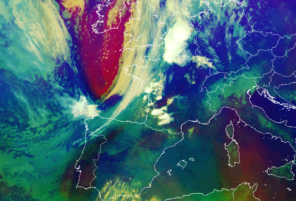
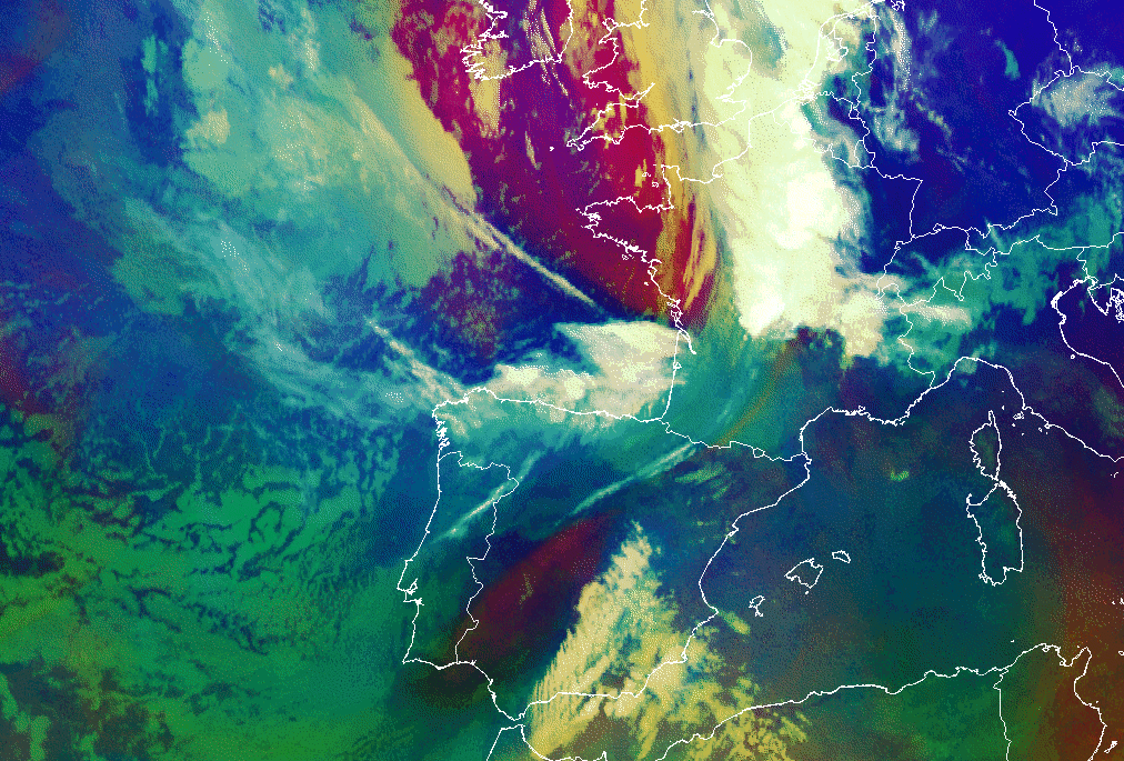
The above mentioned process can be clearly identified by means of Airmass RGB imagery (WV6.2-WV7.3; IR9.7-IR10.8; WV6.2i). As shown by the two images below, in the beginning the Spanish Plume is characterized by the typical greenish or bluish area within which bright white spots appear, indicating the developing convective cells. The purplish red area related to the cold air mass lies relatively far on the rear side of the elongated greenish yellow cloud layer of the cold front. In the mature stage the cold front cloudiness has dissolved, while the cold air mass is located immediately upstream of the spread Spanish Plume. More on the different coolers observed in this Airmass RGB can be found here .
|
03 July 2005/21.00 UTC - Meteosat 8 Airmass RGB image (WV6.2-WV7.3, IR9.7-IR10.8 and WV6.2i)
|
04 July 2005/06.00 UTC - Meteosat 8 Airmass RGB image (WV6.2-WV7.3, IR9.7-IR10.8 and WV6.2i)
|
|
|