Cloud Structure In Satellite Images
Appearance in the basic channels
IR10.8 imagery:
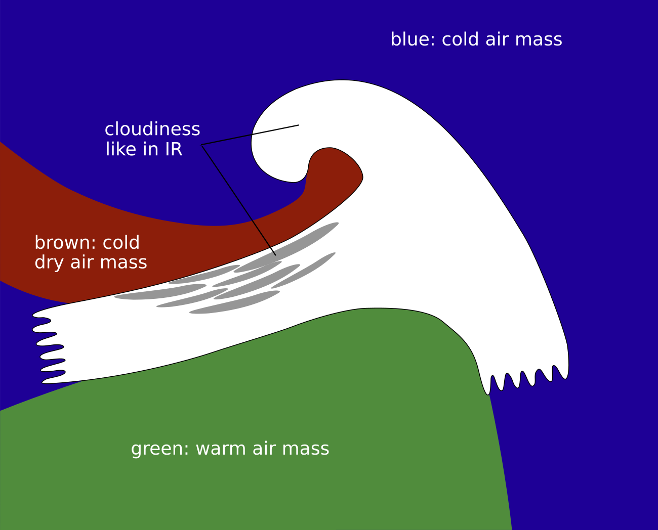
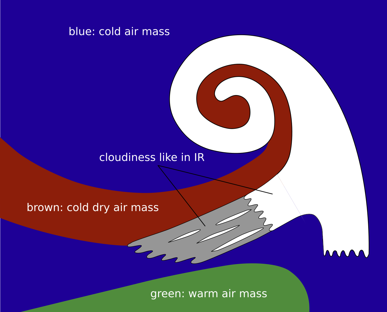
- Two main cloud configurations are seen during the initial stages of a rapid cyclogenesis: a frontal cloud band usually oriented east to west and clouds with warmer tops that form an increasingly dense shield, a so-called "cloud head", on the poleward side of the frontal cloud band and protruding from below it. The developing cloud head varies between grey and light grey in the IR channels, mostly with higher tops on the poleward side.
- Dry sinking air originating from the lower levels of the stratosphere on the cyclonic side of a jet stream is advected downstream. This leads to a dark, cloud-free area between the cloud band of the cold front and the cloud head, thereby creating a V-pattern (often also called a dry slot).
- During the advanced stages the cloud head grows to a cyclonically curved cloud spiral with a broad dark area between the spiral and the frontal cloud band; additionally, the rear part of the cold frontal cloud frequently dissolves as a consequence of sinking dry air.
- Further development leading to the mature stage of the cyclone often includes a cloud spiral around the low centre.
WV6.2 imagery:
- WV images have an important role in identifying the possibility of rapid cyclogenesis initiation.
- In the initial stage of the development a dark grey stripe can be seen along the northward edge of the white frontal cloud band. This stripe represents dry air sinking from the stratosphere along the cyclonic side of a jet stream.
- Before the development starts, the dark grey stripe is more distinct upstream of the cloud head.
- In the next stage the dark grey stripe approaches the cloud head while becoming darker and darker (indicating dry air moving downwards in the upper troposphere) and finally forming a typical V-pattern together with the cloud head.
- During the advanced stages the cloud head grows into a cyclonically curved cloud spiral with a broad black area between the spiral and the frontal cloud band.
- A further dark stripe often develops along the north- to north-eastern boundary of the cloud head in the cold air region within the cold airmass, indicating sinking movement. This is in connection with a second jet streak which often develops there.
VIS0.6 imagery:
- During their initial stages both the west-to-east oriented frontal cloud band as well as the cloud head appear white in the VIS image, indicating fairly thick cloud depth.The clouds have an irregular structure and sometimes fibrous edges on the poleward edge of the frontal cloud band.
- As the top of the frontal cloud band is higher than that of the cloud head, the frontal clouds can cast a distinct shadow on the cloud head, which is visible in VIS images.
 |
 |
 |
 |
Legend:
Schematics for the stages of Rapid Cyclogenesis seen through the basic channels IR, WV and VIS
ul.: initial stage; ur.: development stage; ll.: advanced stage; lr.: mature stage.
*Note: click on the image to access the image gallery (navigate using arrows on keyboard)
Appearance in the basic RGBs:
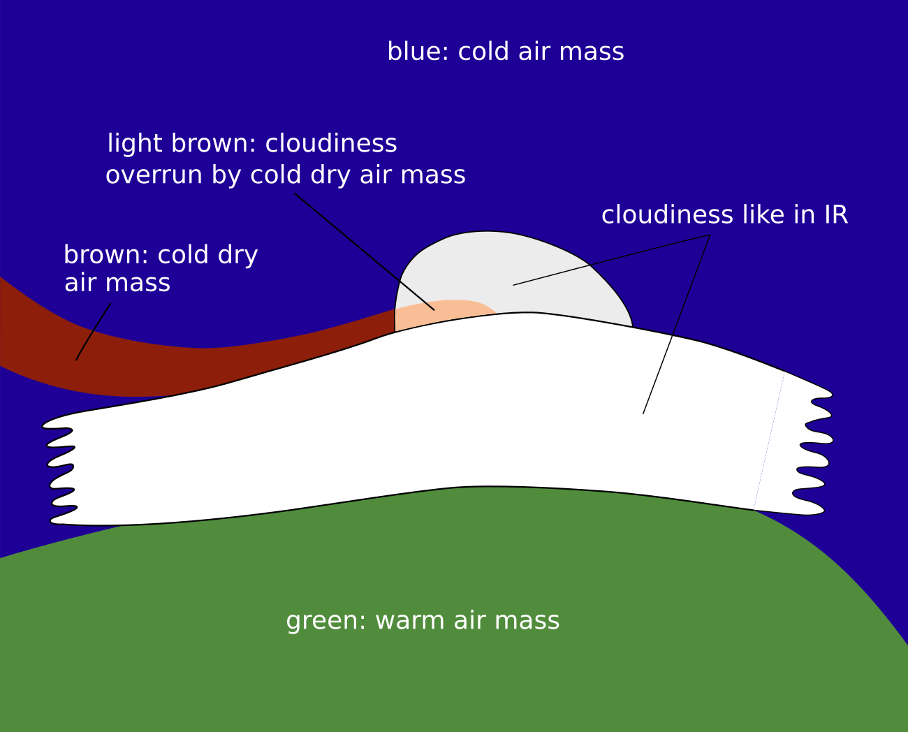
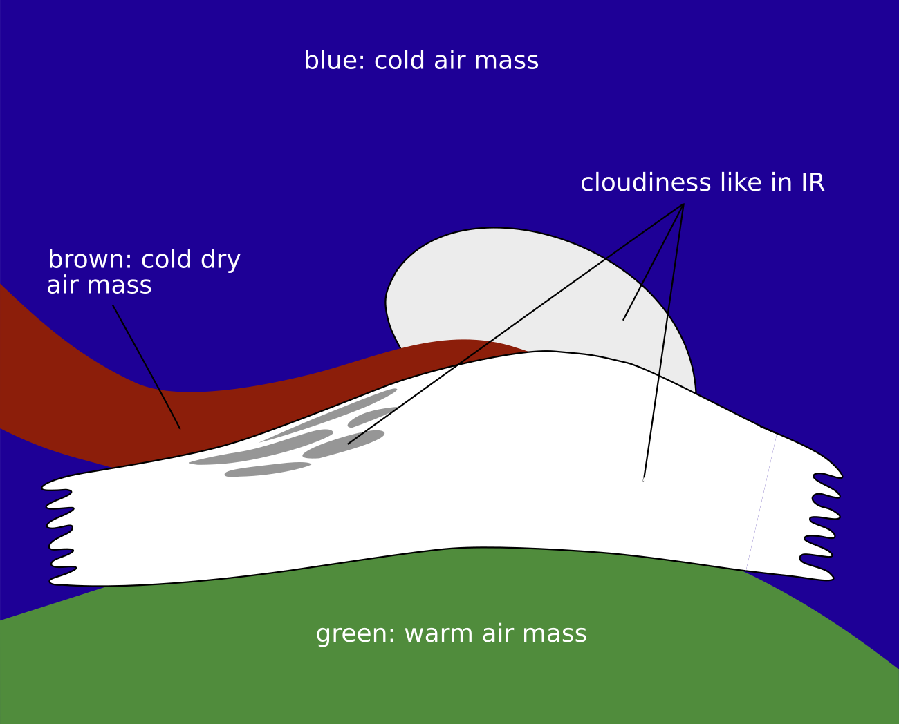
Airmass RGB
The most important feature in an airmass RGB during the whole development is the dark-brown stripe along and at the rear of the frontal cloud band; it is indicative of the sinking cold and dry stratospheric air. Typically, in the initial phase there is mostly only a stripe extending from west to northwest, towards the rearward edge of the cloud head. As the development continues the stripe broadens and intensifies into a distinct V-pattern between the cloud head and the frontal cloud band. Finally, during the advanced stage, the V-pattern transitions into a circular hole area in the centre of the developing cloud spiral. This development makes the acceleration of the rapid cyclogenesis clearly visible. From the advanced to the mature stage, very intensive dark-brown colours fill the whole area within the spiral.
The clouds look very similar in the IR images. Sometimes, in the initial stage, the southern part of the cloud head is overrun by dry air which results in some brownish shadows there.
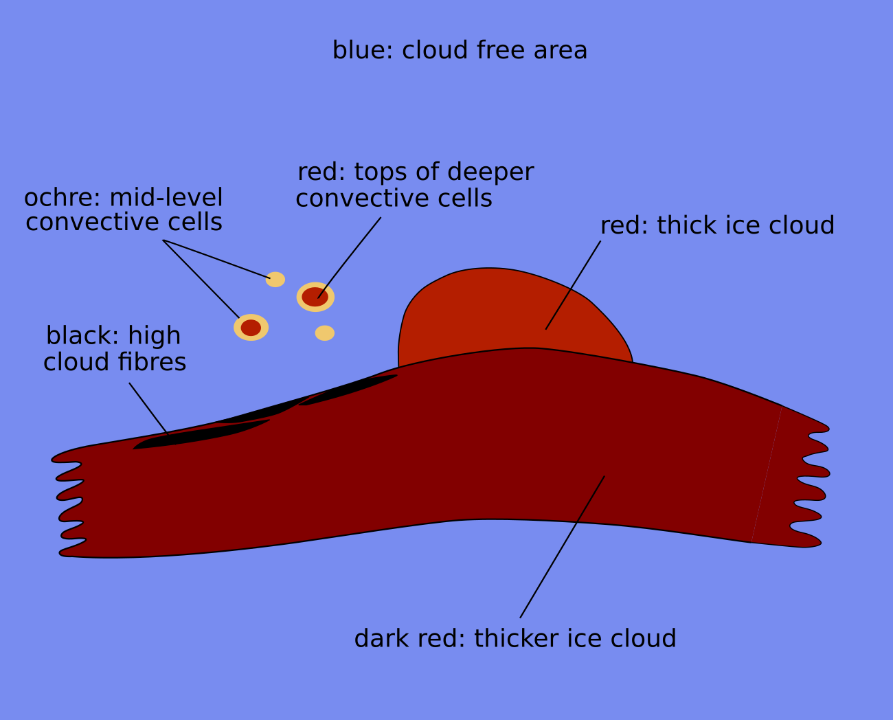
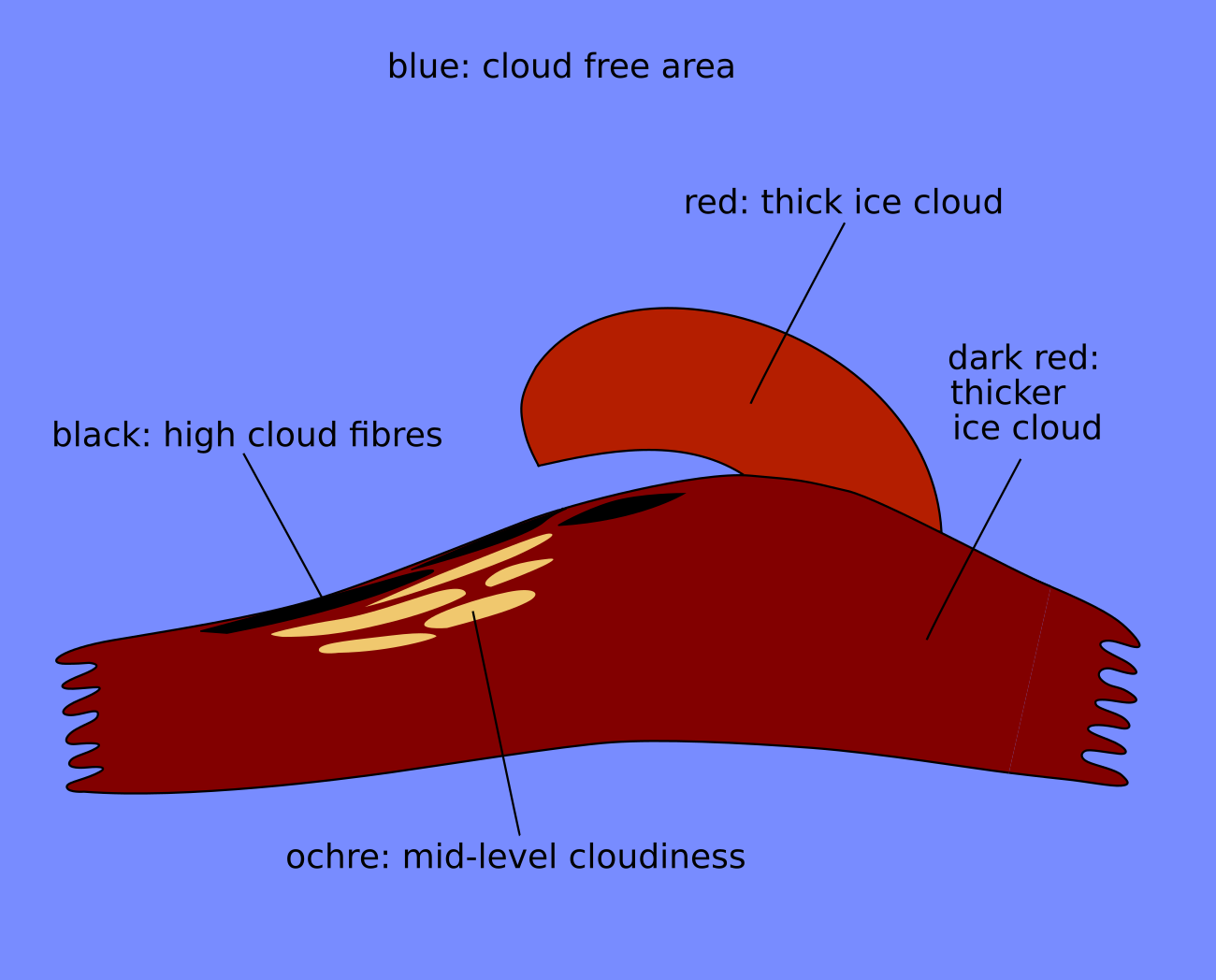
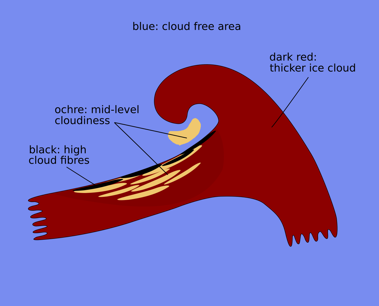
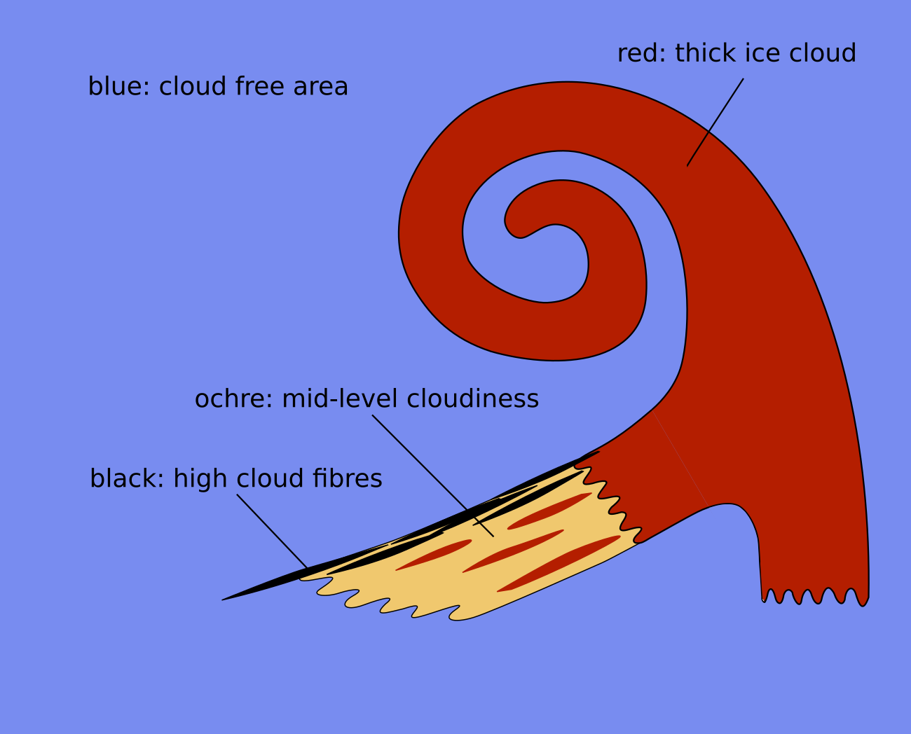
Dust RGB
The surroundings of the cloud system undergoing rapid cyclogenesis have blue colours in all development stages. In these locations which only differs if thin low or mid-level clouds exist-indicated by ochre or green cloud patches.
In the initial stage, the cloud head which appears in the IR images is less bright and colder than the frontal cloud as seen in the dust RGB. If visible, only small differences exist between the two cloud systems. Both parts consist of thick ice cloud. However, a dissolution of the clouds in the frontal cloud band can often be observed by the development of ochre colours. In those cases, a black cloud fibre remains at the northern boundary of the frontal cloud band where the jet axis is located. In advanced and mature stage later on, the cloud spiral appears dark-red due to the thick ice cloud.
 |
 |
Legend:
Schematics of basic RGBs; initial phase
left: airmass; right: dust.
 |
 |
Legend:
Schematics of basic RGBs; development phase
left: airmass; right: dust.
 |
 |
Legend:
Schematics of basic RGBs; advanced phase
left: airmass; right: dust.
 |
 |
Legend:
Schematics of basic RGBs; mature phase
left: airmass; right: dust.
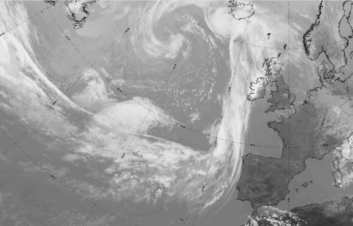
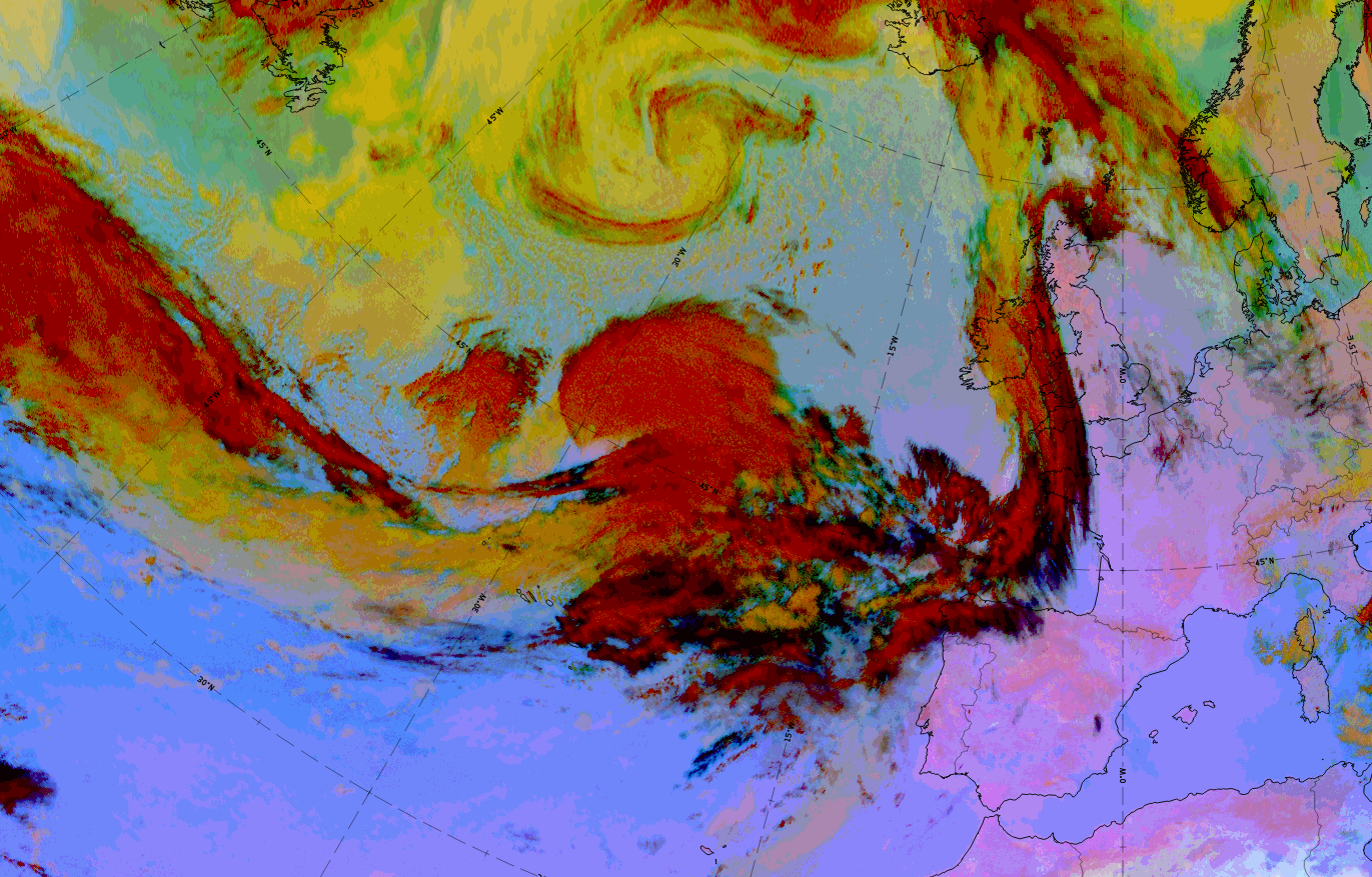
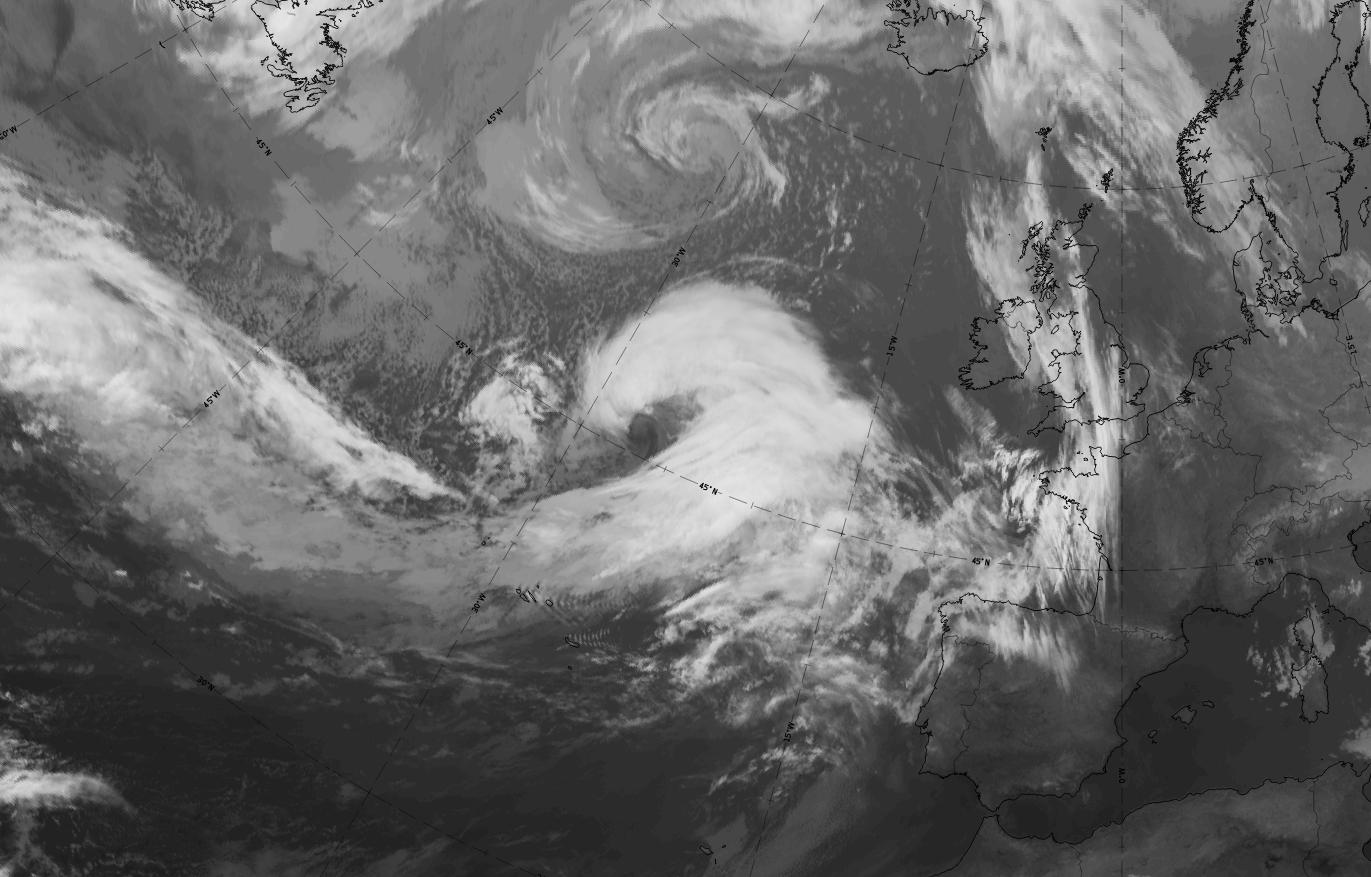
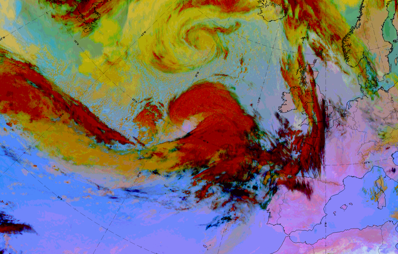
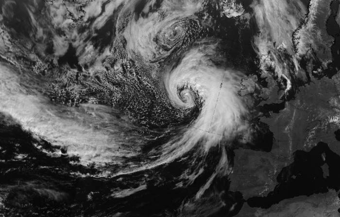
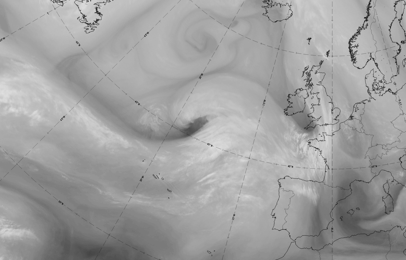
The case of 20 - 21 May 2020 is a clear example which shows all of the development stages of a Rapid Cyclogenesis very well. The development takes place in the Atlantic, starting from approximately 45 N, 30 W moving on a slightly north-westward path towards the British Isles. The rapid development takes place from 20 May 18 to 21 May 06 UTC with a central pressure drop of 25 hPa at the 1000 hPa level. In the initial and development stages there is a comma-like cloud feature to the west of the cloud head. Note that the comma-like cloud is a speciality of this case that does not belong to the rapid cyclogenesis development and dissolves during the whole process.
Rapid cyclogenesis: initial stage
|
|

|
|

Legend:
20 May 2020, 12UTC: initial stage
1st row: IR (above) + HRV (below); 2nd row: WV (above) + Airmass RGB (below); 3rd row: Dust RGB + image gallery.
*Note: click on the image to access the image gallery (navigate using arrows on keyboard)
| IR | Cloud head very bright; frontal cloud band dark grey; bright fibre at jet axis oriented from west to east. |
| HRV | Cloud head very bright; frontal cloud band grey; grey cloud fibre at jet axis oriented from west to east. |
| WV | Cloud head light grey; dark stripe from west to east ending at the western boundary of the cloud head. This represents the approaching, sinking, dry stratospheric air. |
| Airmass RGB | Broad blue band in the area of the frontal cloud band represents the cold air mass; a dark-brown stripe to the north extending from west to the western edge of the cloud head indicates the sinking, dry stratospheric air. |
| Dust RGB | Dark-red colours for the cloud head; ochre colours for the frontal cloud band; and dark-red to black colours for the fibres at the jet axis. |
| General remark | In this case the first two stages deviate from the schematics which show the usual situation. The cloud head amount is more intensive than the frontal cloud amount which highlights an exceptionally strong rising relative stream in the area of the cloud head, and only a weak warm conveyor belt in the area of the cold front band. |
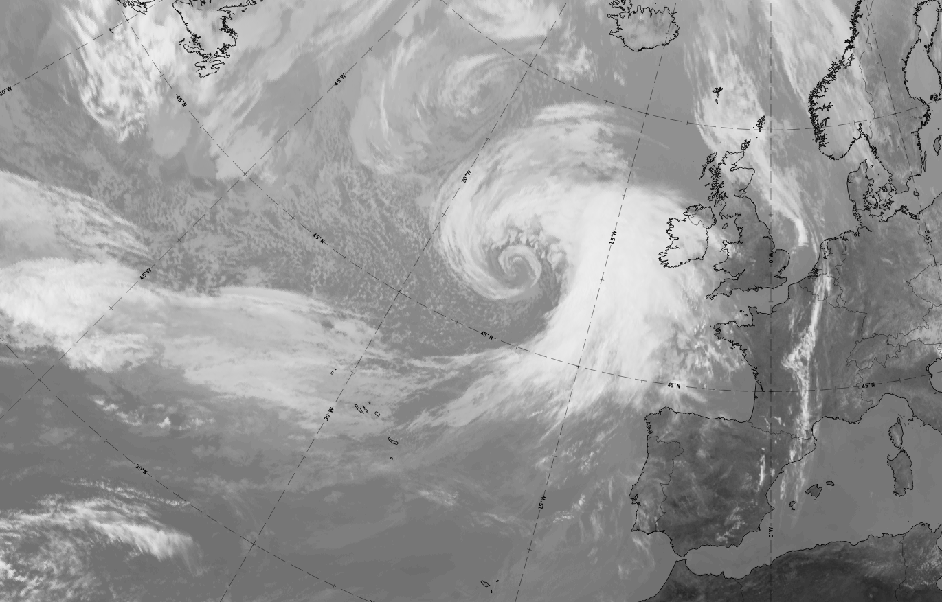
Rapid cyclogenesis: development stage
*Note: click on the image to access the image gallery (navigate using arrows on keyboard)
|
|


Legend:
21 May 2020, 00UTC: development stage
1st row: IR; 2nd row: WV (above) + Airmass RGB (below); 3rd row: Dust RGB + image gallery.
*Note: click on the image to access the image gallery (navigate using arrows on keyboard)
| IR | Cloud head and eastern part of cold front are very bright; a bright fibre at the jet axis is oriented from west to east. Most important feature: a black V-pattern between cloud head and the frontal cloud band, indicating the start of the rapid deepening of the low pressure. |
| HRV | Not available. |
| WV | Cloud head and eastern part of cold front are very bright; black stripe to the north of the cloud band ends in the V-pattern between the cloud head and the cold front, and indicates the east-ward protrusion of the dry stratospheric air. |
| Airmass RGB | Corresponding to the WV image, the dark-brown stripe ends in the V-pattern and indicates the east-ward protrusion of the dry stratospheric air. |
| Dust RGB | Dark-red colours for the cloud head; ochre colours for the frontal cloud band and dark-red to black colours for the fibre at the jet axis. The area in the V-pattern shows blue colours indicating the cloud free ground below, caused by the sinking air within the centre of the cyclonic circulation. |
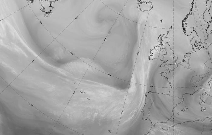
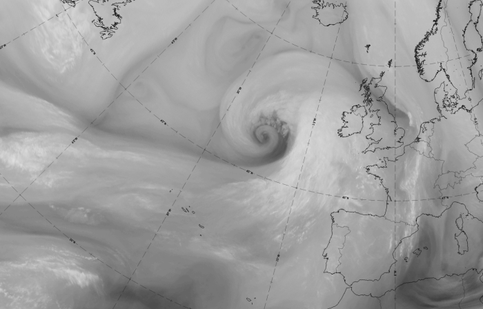
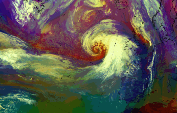
Rapid cyclogenesis: advanced stage
*Note: click on the image to access the image gallery (navigate using arrows on keyboard)
|
|

Legend:
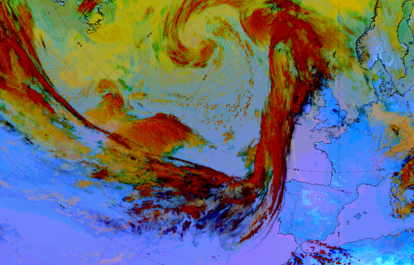
21 May 2020, 03UTC: advanced stage
1st row: IR; 2nd row: WV (above) + Airmass RGB (below); 3rd row: Dust RGB + image gallery.
*Note: click on the image to access the image gallery (navigate using arrows on keyboard)
| IR | Cloud spiral and eastern parts of the frontal cloud bands are very bright. |
| HRV | Not available. |
| WV | Whole frontal system is white to light grey. The black stripe at the northern edge of the cold front streams into a large black-coloured hole in the centre of the developing cloud spiral. |
| Airmass RGB | Corresponding with the WV image, the dark-brown stripe ends in the centre of the developing cloud spiral, indicating dry stratospheric air is sinking at the centre of the occlusion spiral. |
| Dust RGB | Dark-red colours in the cloud spiral of the cyclogenesis and the eastern parts of the frontal cloud bands; ochre colours for the western parts of the cold front cloud band and black colours for the fibre at the jet axis. The centre of the cloud spiral is partly blue where it is cloud free and partly ochre where there are low cloud patches. |
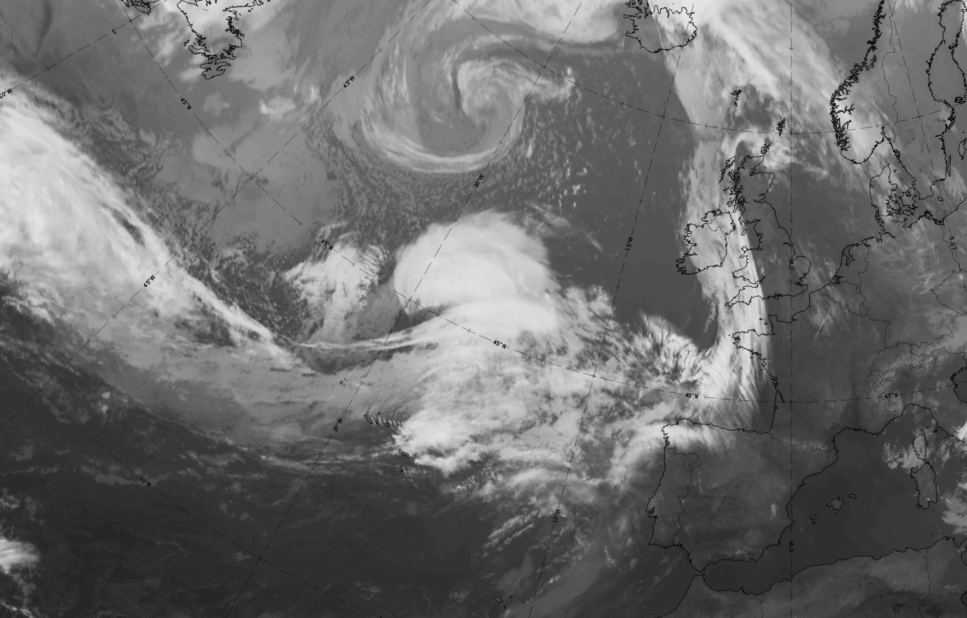
Rapid cyclogenesis: mature stage
|
|

|
|
Legend:
21 May 2020, 12 UTC: mature stage
1st row: IR (above) + HRV (below); 2nd row: WV (above) + Airmass RGB (below); 3rd row: Dust RGB + image gallery.
*Note: click on the image to access the image gallery (navigate using arrows on keyboard)
| IR | Developed cloud spiral and frontal cloud bands are very bright. |
| HRV | Developed cloud spiral and frontal cloud bands are very bright. |
| WV | Developed cloud spiral and frontal cloud bands are light grey to bright. Large dark grey to black area exists in the centre of the cloud spiral |
| Airmass RGB | Corresponding to the WV image, the dark-brown stripe ends in the centre of the developed cloud spiral and indicates the dry stratospheric air there. |
| Dust RGB | Dark-red colours for the cold and warm front system and for large areas in the occlusion spiral. Towards the centre of the spiral, ochre cloud areas become larger indicating the dissolution of the thicker cloud there. Other than some ochre cells in the cold air behind the frontal system, blue colours indicate cloud-free ground. The black fibres and areas at the south-western edge of the cold front band indicate thin, high-level ice cloud exist there. |
Summarising, there are two major features of a rapid cyclogenesis seen in satellite images and image loops:
- A mainly west to east oriented cold front-warm front cloud band together with a cloud head on the poleward side;
- An approaching dark grey stripe in the WV image. As soon as the leading edge of this dark grey strip becomes darker and wider, close to the area between the cloud head and frontal cloud band, the rapid development will take place in just a few hours.
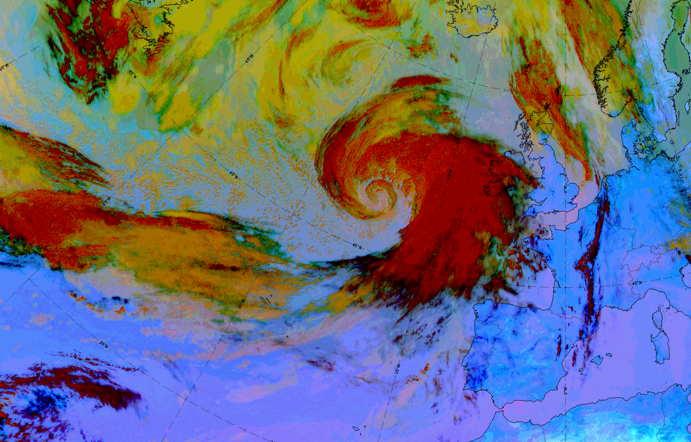
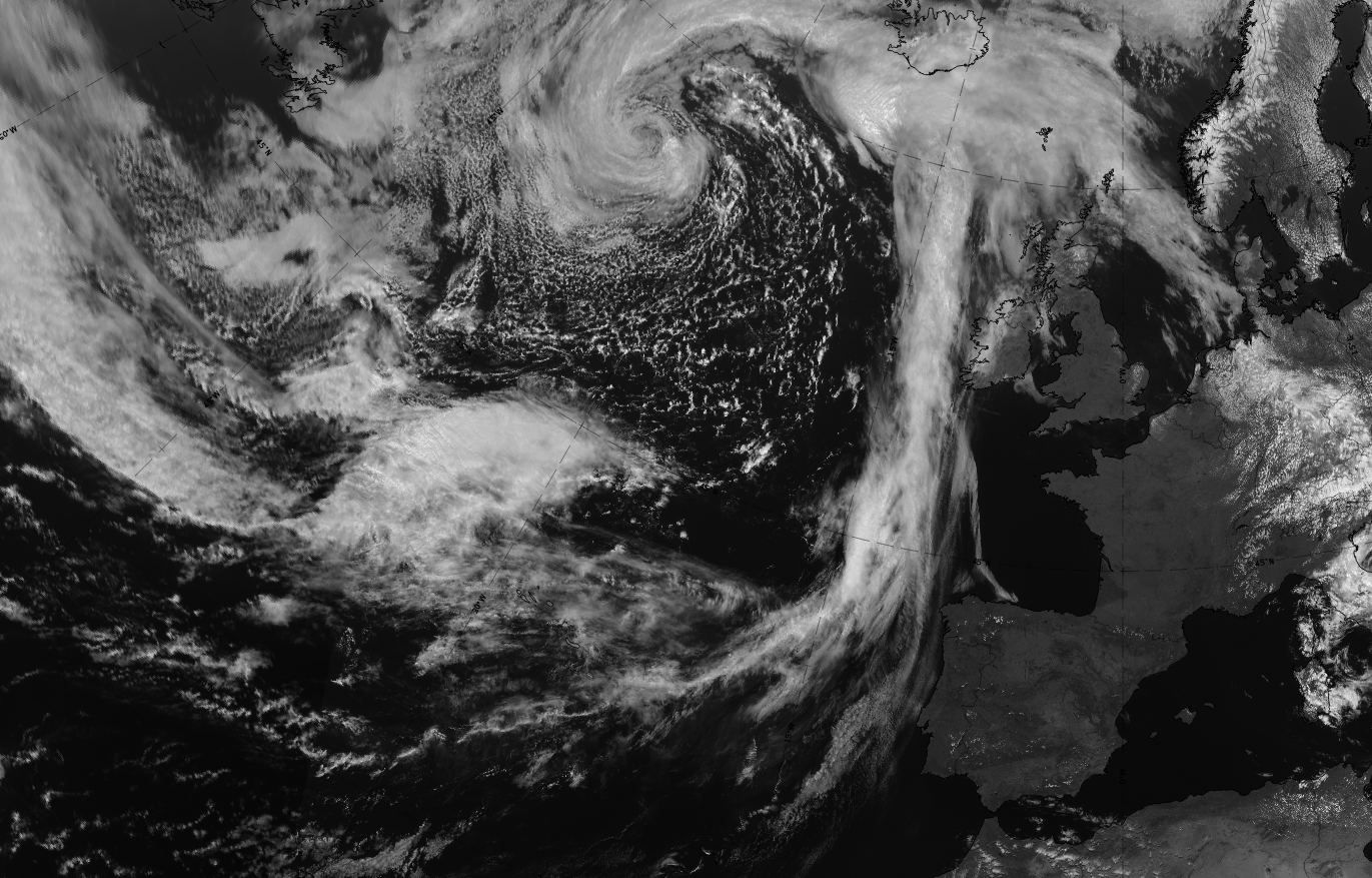
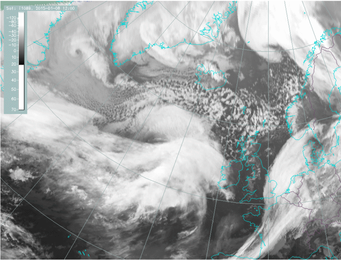
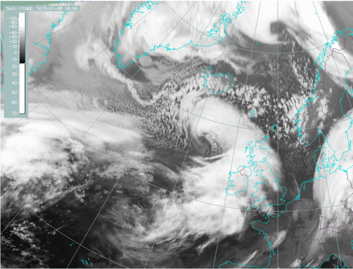
Another case used throughout all chapters of this conceptual model took place over the eastern Atlantic from 7 to 9 January 2015 and demonstrates the typical structures and the development of a typical rapid cyclogenesis. This case shows some features which are typical for a rapid cyclogenesis but cannot be observed distinctly in the case study above: a development loop, as well as the development of some small scale band features in the last stages.
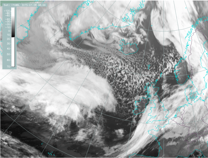 |
 |
 |
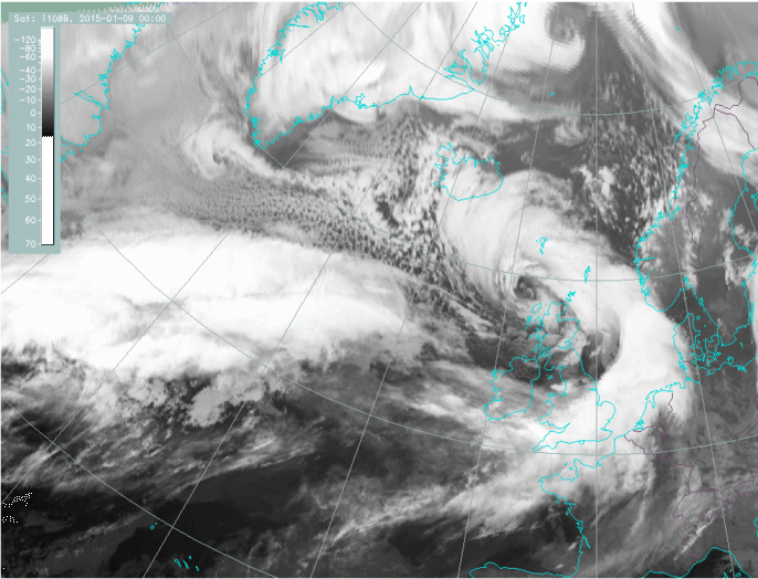 |
Legend: 8-9 January 2015, IR images
u.l.: 8 January 06 UTC: initial stage; u.r.: 8 January 12 UTC: development stage; l.l.: 8 January 18 UTC: advanced stage; l.r.: 9 January 00 UTC: mature stage
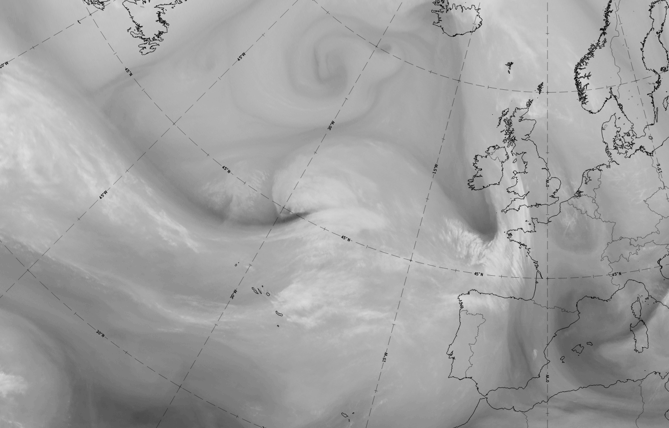
In the advanced and mature stages, when the cloud spiral is well developed and circling the cyclone's centre, parallel cloud lines can appear close to the innermost part of the cloud spiral. These cloud bands are parallel rain bands. Although rain bands are by their nature more visible on radar than in satellite images, they are mentioned here because they can appear together with a very dangerous phenomenon, a sting jet. The sting jet will be described in more detail in the chapter on weather phenomena.
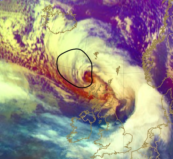
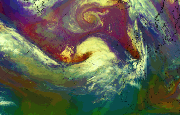
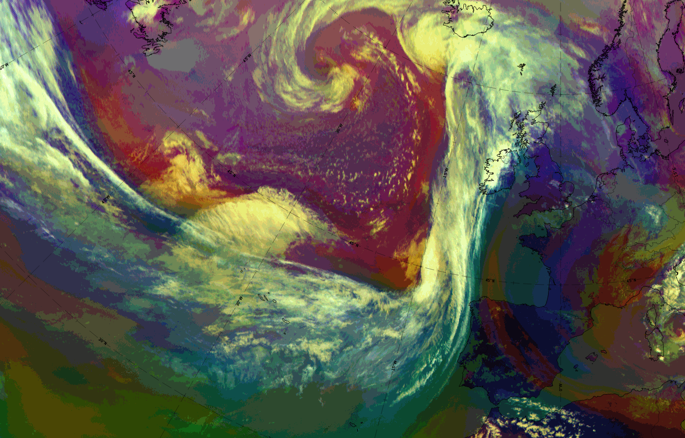
Fig. 9: 9 January 2015, 00 UTC, airmass. The black line encompasses an area of banded cloud which can be correlated to severe weather events in terms of wind and convection.
*Note: click on the image to access the image gallery (navigate using arrows on keyboard)
The following loops show a very rapid development of the depression over 12 hours from 990 hPa on 8 January 2015, 06 UTC to the extreme low value of 965 hPa on 8 January 2015, 18 UTC.
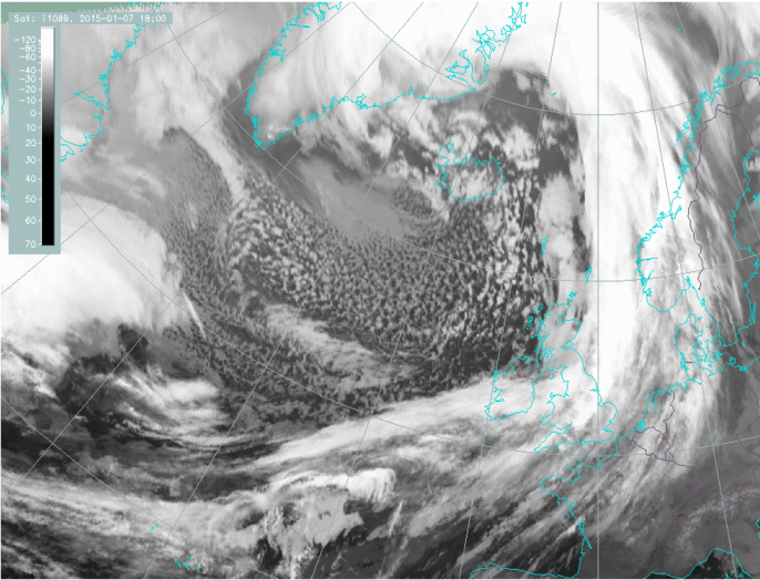
Fig. 10: 9 7 January 2015, 18 UTC - 9 January 2015, 06 UTC, 15 minute image loop; IR 10.8.