Cloud Structure In Satellite Images
Jet Fibres are long and narrow stripes of high, cold clouds, frequently found in satellite images. From the early days of satellite image interpretation, these clouds were considered to be connected to the jet stream and were used to identify the axis of the jet stream.
- Jet Fibres can appear wherever there are jets, but they are more easily recognisable over the ocean than over the land because of the greater contrast they have against the sea surface.
- Jet Fibres are narrow with the width on the order of magnitude of several tens of kilometres (usually less than 100). They may be very elongated, with a length on the order of magnitude between several hundreds to a couple of thousand kilometres.
- In most cases Jet Fibres persist for 8 to 12 hours. However, in some cases they dissipate and new ones develop with the whole process lasting for 24 hours or even longer.
Although they can be detached from the synoptic scale systems, they are most often found in two positions:
- A low-amplitude upper-level ridge (above the Warm Front Shield (see Warm Front Shield)
- To the east of a high-amplitude trough behind a Cold Front (see Cold Front). There are also cases when Fibres appear at an angle to the Cold Front, or even perpendicular to it. This occurs when the Cold Front is a Kata type (see Cold Front).
Jet fibres as continuation of Warm Front Shields
Appearance in the basic channels:
They appear white (or very light grey) in both IR and WV images, with a pronounced fibrous structure. In WV images they are almost always accompanied by black stripes on the cyclonic (left) side. In VIS images, Jet Fibres are nearly transparent with colouring varying from light grey to grey. Although their colouring may be very similar to that of the surrounding clouds, their shape is very different, making them easily identifyable. When a fibre appears above a lower-level cloud feature, the cloud texture is different, which makes the fibre distinct from the surroundings. VIS images sometimes reveal that the fibre casts a shadow on the cloud below or the surface below.

Appearance in the basic RGBs:
Airmass RGB
The cloud fibres extend from the leading edge of the cloud bulge of the Warm Front shield east and southeastward, where they usually exist at the sharp separation point of the blue (cold) and dark brown (dry) airmasses.
The fibres themselves look as bright and white in the airmass RGB as in the IR image.
Dust RGB
The Jet Fibres lead above an area of typical cold air cloud cells - an area which is blue in the cloud free region and is filled up with ochre to dark red within the cloud cells.
The fibres appear (dependent on their thickness) as colours between dark red and black, representing either thick or translucent ice cloud.
 |
 |
Legend: Schematics for basic RGBs Left: airmass RGB; right: Dust RGB
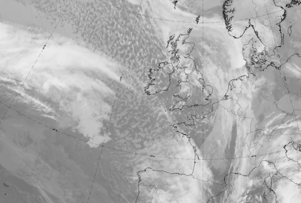
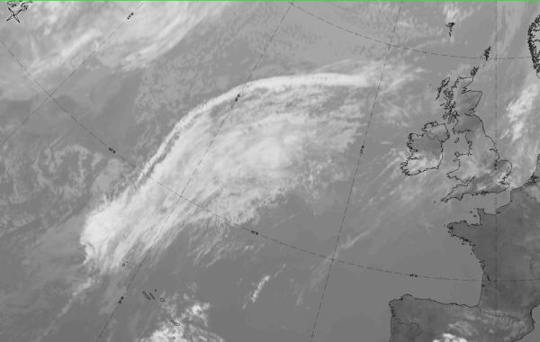
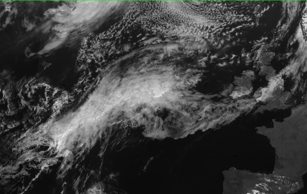
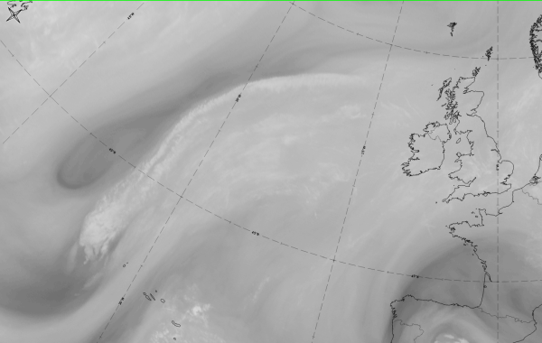
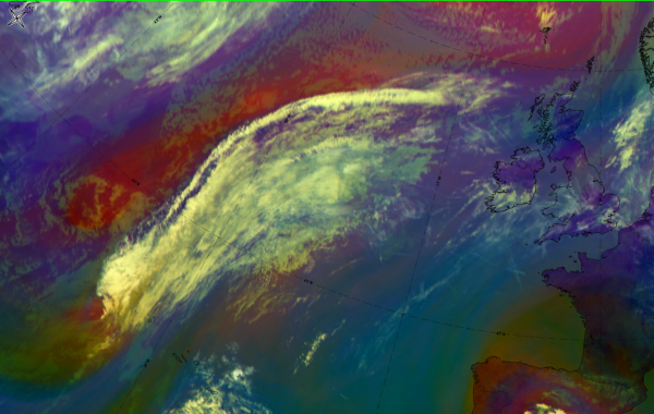
The case of 11 November 2019 at 12 UTC shows a good example for Jet fibres which lead from the edge of a warm front shield over the Atlantic across SW Ireland into France.
|
|
|
|
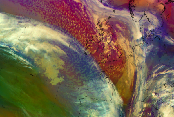

11 November 2019 at 12UTC: 1st row: IR (above) + HRV (below); 2nd row: WV (above) + Airmass RGB (below); 3rd row: Dust RGB + image gallery.
*Note: click on the Dust RGB image to access image gallery (navigate using arrows on keyboard)
| IR | Bright and fibrous. |
| HRV | Dark grey above cold air cloudiness. |
| WV | Bright grey band of high humidity with a sharp edge to the dry area in the northeast. The Cloud fibres can be found along this sharp edge where the grey shades are brighter. |
| Airmass RGB | A broad blue band representing cold air, with white fibres at the north-eastern border. Becomes a dark brown area representing cold dry air. |
| Dust RGB | Fibres are black to dark-red representing ice cloud of different thickness. |
Jet Fibres at the rear of Cold Fronts

Appearance in the basic RGBs:
Airmass RGB
The cloud fibres are along the rear side of the cold front cloud band, with the cold front cloud on the eastern and dark-brown bands or areas on the western side; the latter representing the sinking cold and dry air behind the cold front.
The fibres themselves look as bright and white as they do in the IR image; a part of them are slightly behind the cloud band partly directly at the rear.
Dust RGB
The jet fibres are along the rear side of the cold front cloud band, sometimes visible as black stripes in cases of transparent high ice cloud. Otherwise the jet fibres can appear as dark red as the cold front cloud, in cases of thick ice cloud.
 |
 |
Legend: Schematics for basic RGBs, Left: airmass RGB; right: dust RGB
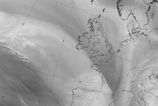
The case of 26 May 2020 at 12 UTC is a good representation of cloud fibres at the rear of, and parallel to, a cold Front cloud band over the Atlantic. In this case, the frontal system is in a wave stage and the jet fibres continue along the leading edge of the warm front band as well.
|
|
|
|

26 May 2020 at 12UTC: 1st row: IR (above) + HRV (below); 2nd row: WV (above) + Airmass RGB (below); 3rd row: Dust RGB + image gallery.
*Note: click on the Dust RGB image to access image gallery (navigate using arrows on keyboard)
| IR | A very bright jet fibre at the rear of, and partially separated from, the cold front. Also exists at the leading edge of the warm front band. |
| HRV | Dark grey jet fibre. |
| WV | Very bright at the cyclonic boundary of a broad area of high humidity (in the upper troposphere); black stripe at the cyclonic side, representing sinking dry air. |
| Airmass RGB | Clouds of fibre and frontal bands very similar to IR; dark brown stripes at the cyclonic side of the frontal system, representing sinking dry air. |
| Dust RGB | Cloud fibres are dark red in the centre but more black at the edges; thick ice cloud in the centre becomes more translucent at the edges. |