Meteorological Physical Background
One of the main features in WV images are rather narrow Dark Stripes lying along the cyclonic side of bright bands and fibres. Typically they occur on the cyclonic side of a jet axis, to the rear of Cold Fronts and Occlusions, and along the leading edge of Warm Fronts.
The Dark Stripe represents sinking dry air which could be of stratospheric origin. As such, the stripe can be used:
- as an indication of cloud dissipation from above
- to indicate possible unstable development at the boundary between dry and moist air
Consequently, Dark Stripes are not really conceptual models but are important key parameters within numerous other conceptual models, e.g.:
- Rapid cyclogenesis (see Rapid cyclogenesis )
- Wave (see Wave )
- Jet Cloudiness (Fibre at Jet Axis) (see Jet Cloudiness (Fibre) )
- Front Intensification by Jet Crossing (see Front Intensification by Jet Crossing )
- Cold Front (see Cold front )
- Occlusion (see Occlusion )
- ULL (see Upper Level Low )
Dark Stripes in WV images are especially useful if they are combined with relative streams where they can frequently be found associated with dry intrusions as well as with isentropic potential vorticity.
Dark Stripes in WV images are often accompanied by PV anomalies. The distribution of PV shows a long narrow elongated zone of high PV gradients within the Dark Stripe, often with separate maxima.
Dark Stripes in WV can also be used to detect discrepancies between numerical models and actual observations because of the tight relationship between PV and WV.
|
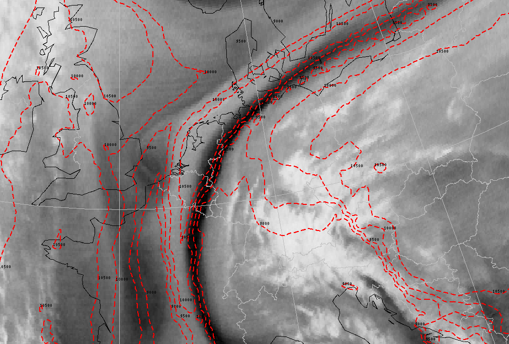
19 November 2002/12.00 UTC - Meteosat WV image; red: height of 2 units potential vorticity
|
|
|
The satellite image above shows a Dark Stripe which extends from south-eastern France via the Benelux towards the Baltic States. Within and near this Dark Stripe the highest gradient of the PV=2 units height contours (tropopause height) can be found.
WV Dark Stripes are not only associated with Potential Vorticity but can also be used as indicators for the advection of Potential Vorticity. Because of the fact that Dark Stripes are narrow and elongated they are difficult to find in numerical model output. Therefore, advection of Potential Vorticity can be used for more detailed forecasts of the potential vorticity field.
In contrast to eulerian and semi-langrangian methods, contour advection is based on a langrangian calculation. A potential vorticity contour advection field consists of a (finite) number of PV contours. A PV contour, in turn is represented by a number of points that are connected with small elementary curves. Every single point has a certain value of potential vorticity (see caption to the schematic below). The points are advected by the local wind on the isentropic surface. As a consequence, the PV contours can be deformed in complicated ways. The advantage of this method is that relatively fine scale features in the analysis can be followed more accurately in space and time than by traditional eulerian methods. However, one should realise that contour advection of PV only holds true under the assumption that the atmosphere is adiabatic and frictionless.
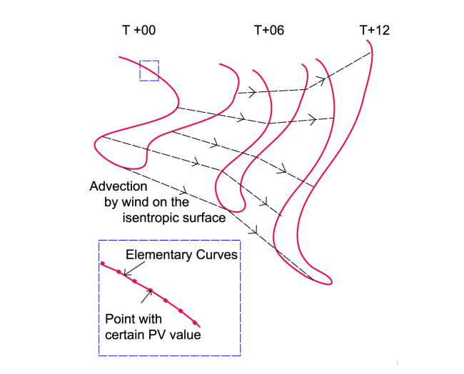
In the PV contour advection field below, the contours are being advected using the analysed and 6-hourly forecast model wind fields on the 218K isentropic surface.
|
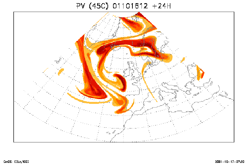
17 October 2001 - ECMWF +24h contour advection; 12 Z Potential vorticity on isentropic surface of 318K
|
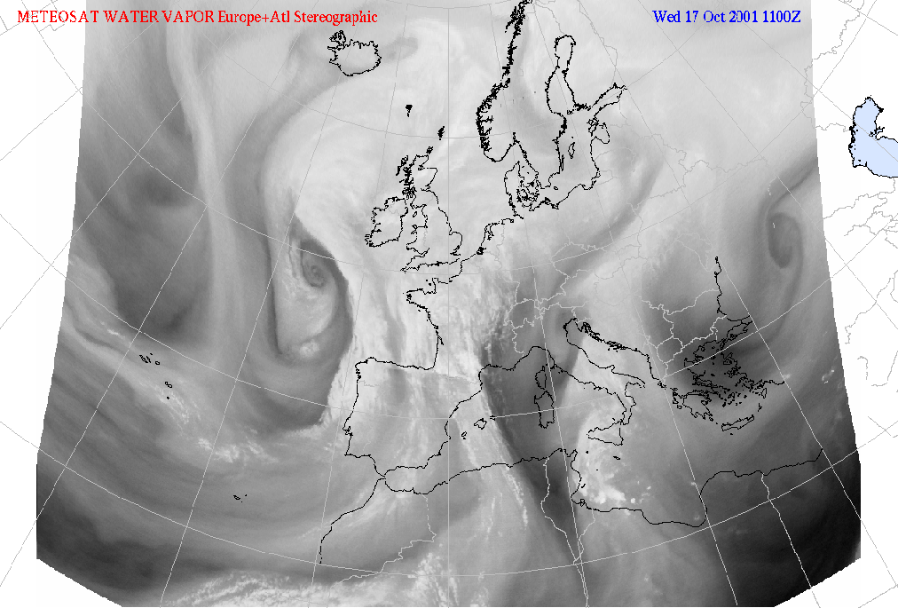
17 October 2001/11.00 UTC - Meteosat WV image
|
|
|
The PV contour advection method shows a lot of fine scale structures which can also be seen in the WV imagery. Therefore this method can also be useful in diagnosing fine scale processes in the upper part of the troposphere.