Key Parameters
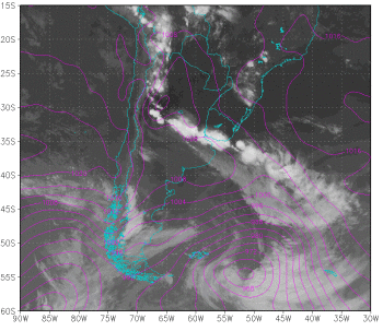
- Sea level pressure: frontal trough and associated low pressure system and post-frontal anticyclone.
- Advection of equivalent potential temperature (EPT) and humidity convergence at 850 hPa: maximum values of both variables at the leading edge of the cold surface front.
- Thermal front parameter (TFP): maximum value of thermal front parameter in the frontal zone.
- Cyclonic vorticity advection at 500 hPa: maximum values ahead of the trough.
- Isotachs and streamlines at 250 hPa: maximum wind associated with the jet stream at high levels. Jet streak orientation is mostly parallel to the CF cloud band
Sea level pressure
|
06 February 2014/00:00 UTC. GOES 13 IR 10.7 image; magenta: sea level pressure
|
|
Advection of equivalent potential temperature and humidity convergence at 850 hPa
|
06 February 2014/00:00 UTC. GOES 13 IR 10.7 image; magenta: Equivalent Potential Temperature at 850 hPa, yellow: humidity convergence at 850 hPa (gr/kg day), green vector (arrows): wind at 850 hPa.
|
|
Thermal Front Parameter
|
06 February 2014/00:00 UTC. GOES 13 IR 10.7 image; green: equivalent thickness, blue: TFP.
|
|
Cyclonic vorticity advection at 500 hPa
|
06 February 2014/00:00 UTC. GOES 13 IR 10.7 image; cyan: geopotential height of 500 hPa, green: positive vorticity advection at 500 hPa, blue: negative vorticity advection at 500 hPa.
|
|
Isotachs and streamlines at 250 hPa
|
06 February 2014/00:00 UTC. GOES 13 IR 10.7 image; green: streamlines at 250 hPa, yellow: isotachs at 250 hPa.
|
|


