Upper Tropospheric Convergence And Divergence
This chapter deals with the EUMETSAT MPEF product "Divergence". The divergence is directly calculated from the field of Atmospheric Motion Vectors (Figure 23). Only high level vectors (above 400 hPa) are considered, and the horizontal resolution for the search area for the cross correlation method is 32 by 32 pixels. AMV are derived by tracking cloud and humidity features in the 6.2 μm WV channel. The MPEF Divergence product represents an atmospheric layer between 100-400 hPa rather than a specific atmospheric level.
EUMETSAT started to operationally disseminate the MPEF Divergence product in 2008 via EumetCast.
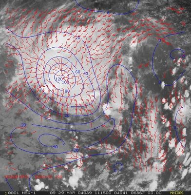
Figure 23: Atmospheric motion vectors derived from MSG 6.2 μm channel (red wind barbs) and divergence (blue lines) calculated from the AMV. The MSG IR10.8 μm image dates from 29 March 2009 at 11:15 UTC.
In this chapter, the AMV-based Divergence product will be presented as an additional tool for diagnosing upper-level environments favorable for deep convection. Although this product also covers tropical areas (e.g. Figure 8 over central Africa), we will concentrate on the mid-latitudes.
The MPEF Divergence product at mid-latitudes
At mid-latitudes, values of the MPEF Divergence product are much smaller than in tropical regions. The reasons for this are the weaker updraft of convective systems at mid-latitudes compared to tropical areas and the lower horizontal resolution of MSG images, which tends to smooth out information.
Upper-level divergence constitutes a favorable environment for deep convection. Acting together with low-level forcing mechanisms such as instability and moisture convergence, it provides an additional trigger for the development of deep convection.
Upper-level divergence is most often encountered at the north-eastern part of an upper-level trough (see Figure 24). If a frontal system is present this would be near the occlusion point and the left exit region of the jet streak.
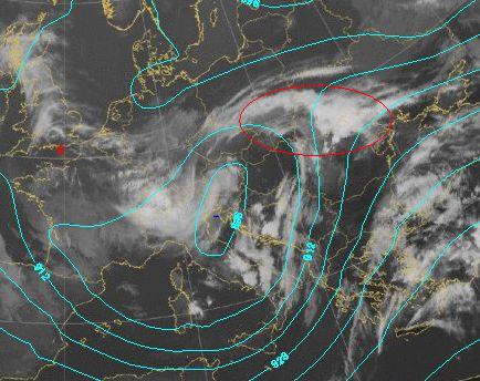
Figure 24: IR image from 22 April 2008 at 06:00 UTC with isolines of the geopotential height at 300 hPa. The red line indicates the area of divergent flow.
C. Georgiev and P. Santourette (2010) investigated 1166 deep convective cells and their position within a region of divergence in the MPEF Divergence product. Their results showed that 76% of deep convective cells initiated in areas of upper-level divergence indicated by the MPEF product.
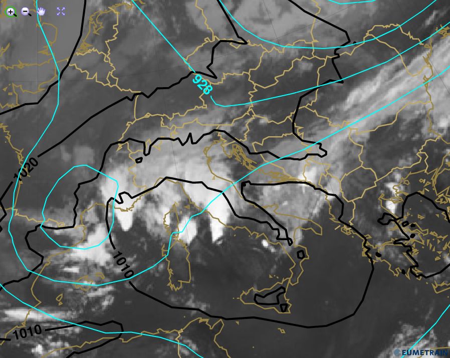
Example: 15 June 2014, 06:00 UTC
A weak surface pressure minimum is located over Italy and the surrounding Mediterranean Sea. The upper atmosphere is characterized by two upper-level troughs, of which only the stronger one over southern France can be seen in the isolines of the geopotential height at 300 hPa. The smaller upper-level trough located over Greece is only visible in the streamline field (see Figure 25).
Convective developments are present in the zone of divergent flow near both upper-level troughs (red circles).
 |
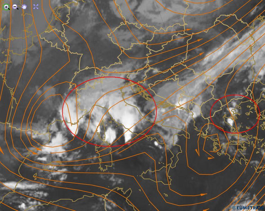 |
Figure 25: IR10.8 μm image from 15 June 2014 at 06:00 UTC. 300 hPa geopotential height (cyan), mean sea level pressure (black), and streamlines at 300 hPa (brown). The red circles indicate the area of divergent flow at 300 hPa.
The MPEF Divergence product calculated from WV6.2 μm images indicates upper-level divergence in both regions. The light blue area in Figure 26 over the Mediterranean Sea south of France as well as the green area over Greece are in good agreement with the diffluent streamlines from the model forecast field. Convection had already developed in these areas 6 hours earlier.
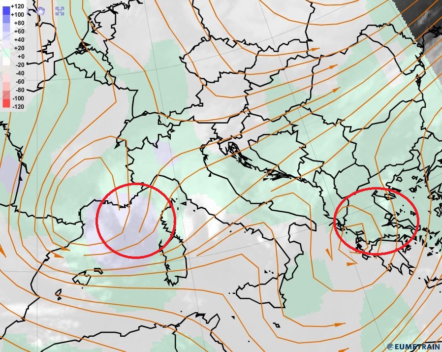
Figure 26: MPEF divergence product and ECMWF streamlines at 300 hPa for 15 June 2014 at 06:00 UTC.
The global instability index product (GII), which shows the lifted index (Figure 27), indicates strong instability in the affected regions. Upper-level divergence acts in favor of the development of deep convection.
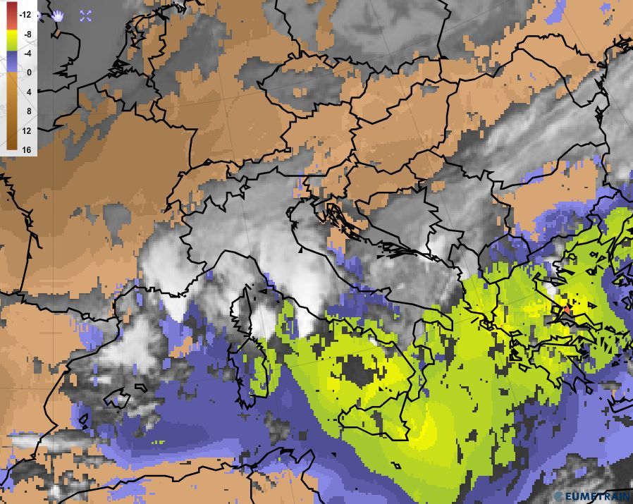
Figure 27: Global instability index (GII) for 15 June 2014 at 06:00 UTC.
Note:
Upper-level divergence alone is not sufficient to initiate the development of thunderstorms. But if it is present, it acts as a trigger in combination with other factors such as instability, orography and moisture convergence in lower levels to build a favourable environment for convective development. Upper-level divergence constitutes an effective trigger in the higher troposphere.