The Kinematic Extrapolation Method
The kinematic extrapolation of frontal cloud bands was one of the earliest applications of satellite-derived cloud motion vectors (CMV). This means that CMV were used to linearly extrapolate the displacement of a front in a time frame up to 2 hours (Very Short Range Forecasting - VSRF), assuming that the frontal cloud band continues its propagation invariably, i.e. in the same direction and with same speed as the CMV indicate.
Figure 16 shows the IR-CMV superimposed on a frontal system over Western Europe. It shows the displacement of the cold front (central France) towards the east, the displacement of the warm front (Switzerland and northern Italy) towards the southeast and parts of the occlusion (northern France, Belgium) towards the northeast.
Notice that since wind speed increases with height, the CMV are largest for high reaching clouds and small for low-level clouds. Due to the applied cross-correlation method, the CMV are not zero over bare ground or very low cloud fields like fog and low stratus (e.g. southeast Germany). This effect results from the selection of a 32 by 32 pixel search area which may contain different types of clouds (e.g. high and low clouds). Therefore this method works best with homogenous and high reaching clouds.
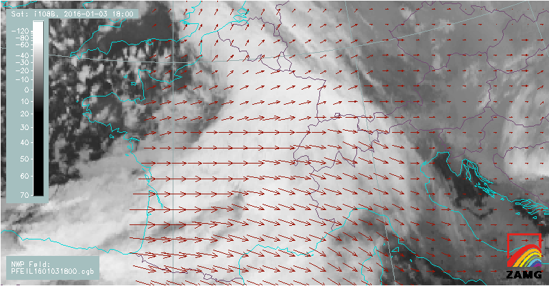
Figure 16: CMV derived from IR10.8 μm superimposed on a frontal system over Western Europe. The length of the red vectors is proportional to the displacement. The MSG image dates from 3 January 2016 at 18:00 UTC.
In the cold season, frontal systems are generally better suited for kinematic extrapolation than in the warm season because they show less dynamic changes. Figure 17 shows a visualization of the kinematic extrapolation method of the same frontal system as above applied to MSG 10.8 μm brightness temperatures (BT).
To better illustrate the frontal displacement, brightness temperatures are divided into classes and coloured accordingly:
Yellow: -30°C to -40°C
Red: -40°C to -50°C
Green: -50°C to -60°C
The corresponding lines in yellow, red and green indicate the position of the frontal system one hour later in time. The position of the lines is deduced with help of the CMV.
|
|
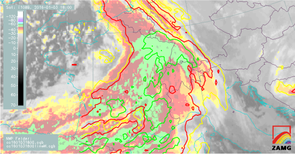
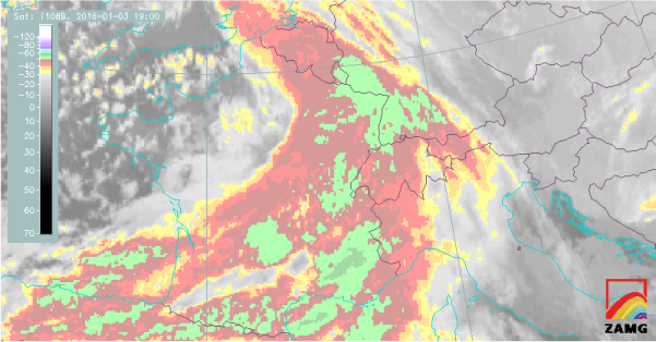
Figure 17: Kinematic extrapolation applied to cloud top temperatures. The MSG IR10.8 μm BT image dates from 3 January 2016, 18:00 and 19:00 UTC. Apply the slider to compare predicted and real cloud position.
It is of equal importance for the forecaster to know not only at what time the frontal system will arrive, but also when related weather phenomena like rain or snowfall will set in at a given geographical position. For this reason, kinematic extrapolation has not been applied to both clouds and synoptic reports of rain, drizzle and snowfall as shown in Figure 18.
As not all parts of the frontal system are connected to precipitation, the forecaster's attention is drawn only to the areas where precipitation occurs.
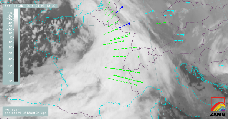
Figure 18: Rain (green), drizzle (blue) and snow (cyan) reports from synoptic stations linearly extrapolated 2 hours into the future (3 January 2016, 18:00 UTC to 20:00 UTC).
Note:
Kinematic extrapolation is a very simple method to forecast the propagation of cloud features and related meteorological phenomena in the domain of VSRF. A time step longer than 2 hours is rarely applicable for extrapolation due to dynamic changes within the frontal cloud band (e.g. embedded convection). Neither does this method account for orographic obstacles.