Synoptic Situation - Re-intensification Phase
If the developmental criteria have been met for transition, Phase 3 of the process,re-intensification occurs.
Many of the characteristics of cyclogenesis are then a familiar feature of mid-latitude development, although remnants of the tropical cyclone can still add some degree of uncertainty, as can the interaction between a transitioning cyclone and existing frontal features.

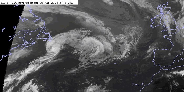
05 Aug 2004/21:15 UTC - MSG IR10.8 image
|
WV Imagery (Meteosat 8 channel 7.3): time sequence
Water vapour imagery is an important forecasting tool which enables us to observe the broadscale patterns such as jets and upper features. During this section we will describe the broadscale patterns and feature apparent during the tropical phase.
Combined satellite imagery RGB : time sequence
An important diagnostic tool is the use of RGB's to aid in the analysis of development. In this section we will investigate the similarities that can be ascertained by using RGB composites. In this section we will use the Air mass RGB (WV6.2-WV7.3, IR9.7-IR10.8, WV6.2 inverted)
IR and WV Imagery (Meteosat 8 channel 10.8, 6.2, 7.3) and MSLP: time sequence
In this chapter we will use the Meteosat IR image and the two WV channels in combination with the surface analysis overlays to establish the surface pressure fields and movement of the system.
Summary of the investigations in this chapter
If the developmental criteria have been met, Phase 3 of the process
is when re-intensification occurs. Many of the characteristics of
cyclogenesis are then a familiar feature of mid-latitude development,
although remnants of the tropical cyclone can still add some degree of
uncertainty, as can the interaction between a transitioning cyclone and
existing frontal features.
As the upper trough to the west of ex-hurricane Alex extends and sharpens the depression begins to re-intensify. On all the MSG channels shown here a developing cloud head can be seen and on both water vapour channels a very distinct dark grey shape can be seen to the west of the upper cloud.
The infra-red imagery shows a distinct frontal structure typical of vigorous depression. The water vapour imagery shows the dark area beginning to shrink reinforcing the theory that the development phase of the depression is coming to an end.
The infra-red imagery shows a extended occluded front winding around the centre of the low. The water vapour imagery shows the dark area to the west of the depression caused by the descending dry stratospheric air becoming lighter in colour.