Table of Contents
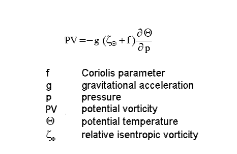
The quasi-geostrophic approach
A basic assumption behind the method is the fact that typical cloud configurations and their structures are the result of certain physical processes in the troposphere and can provide an indication of the existence of those processes. Physical processes can also be visualized with the help of relevant numerical parameters. In the following sub-chapters these parameters and their typical structures are described together with their indicative cloud configurations in satellite imagery and their typical structures.
It should be noted that the intention in the following chapters is to summarize theoretical facts and aspects in the form of equations and relations only as far as they are necessary in the light of satellite imagery interpretation; consequently this is not a complete, in depth theoretical discussion.
Divergence
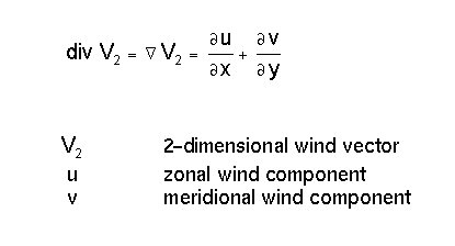
Divergence is a property of the flow field. There is a connection to vertical motion through the Richardson equation:
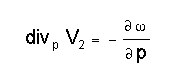
A very simple model describing an ideal situation leads to the following considerations: If there is the assumption of convergence existing at the surface level, upward motion results in the levels above up to the tropopause; at this barrier air cannot rise further and consequently has to diverge there. Therefore a circulation cell is created and cloudiness may develop in the upward motion.
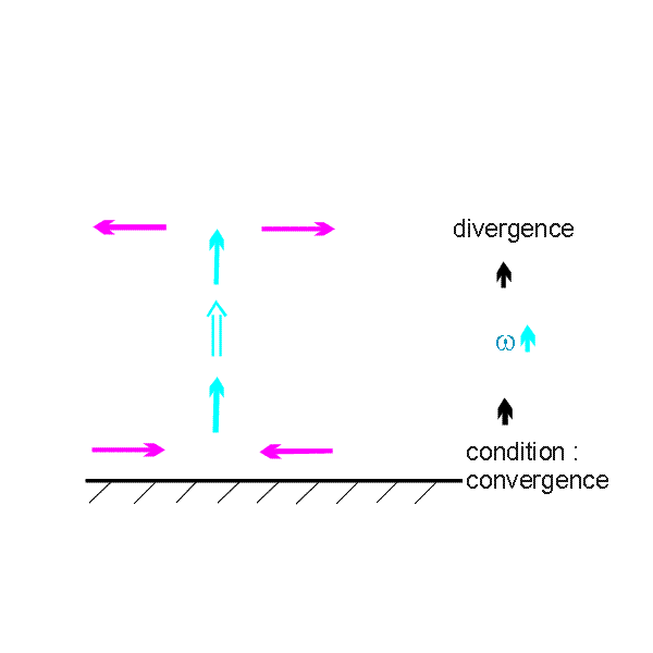
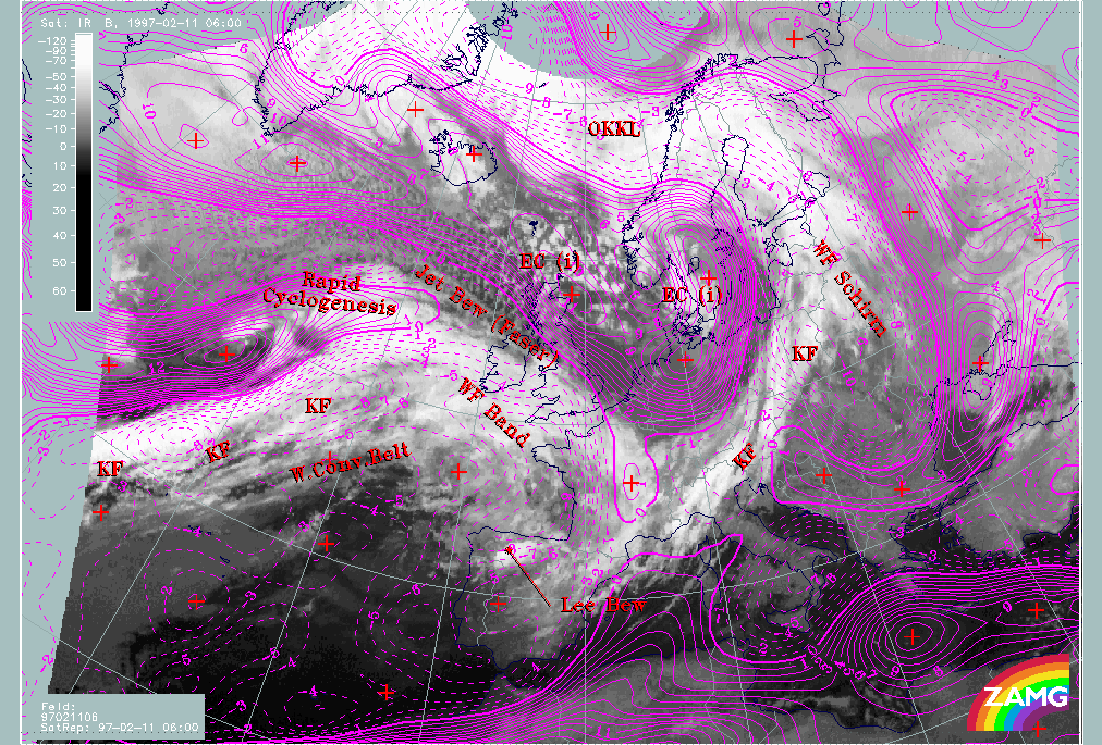
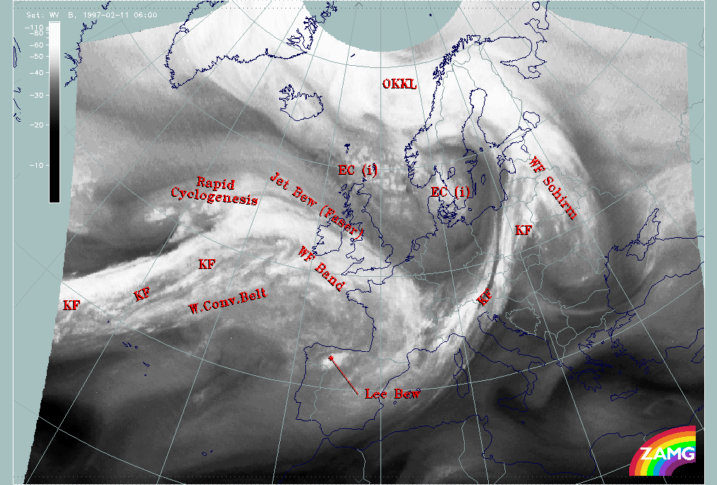
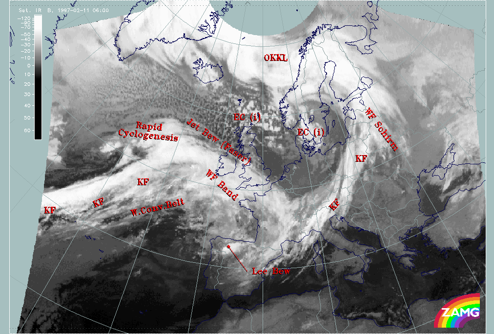
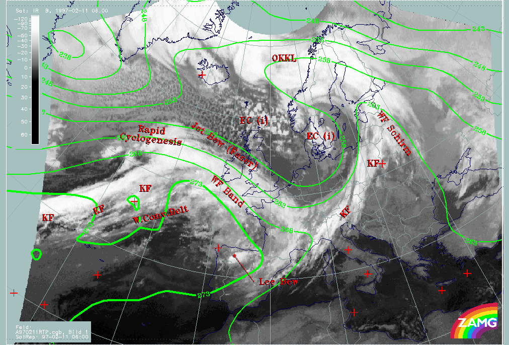
A good example for such a situation is, for instance, frontal cloudiness which can be discused in a test case from 11 February 1997/06.00 UTC.
|
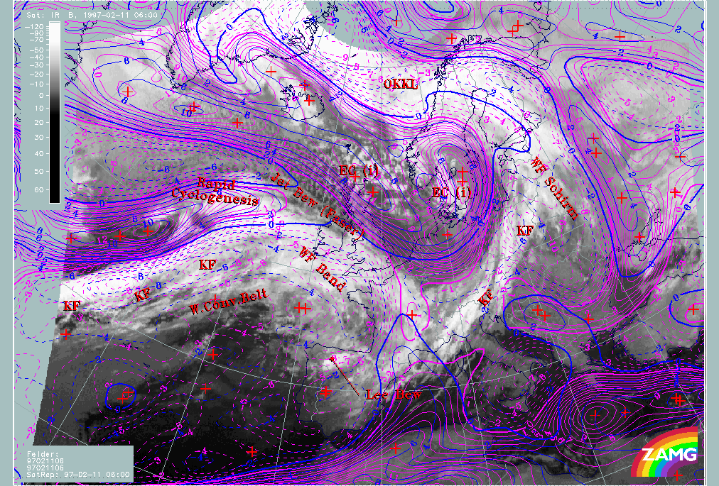
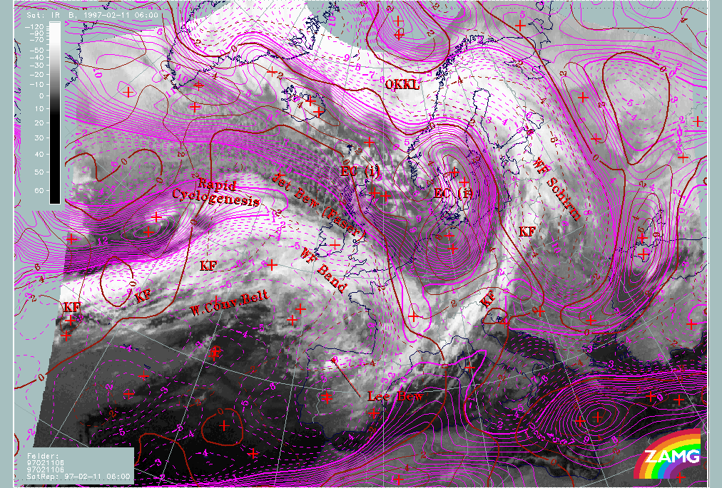
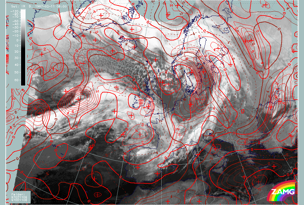
11 February 1997/06.00 UTC - Meteosat IR image; SatRep overlay: names of conceptual models
|
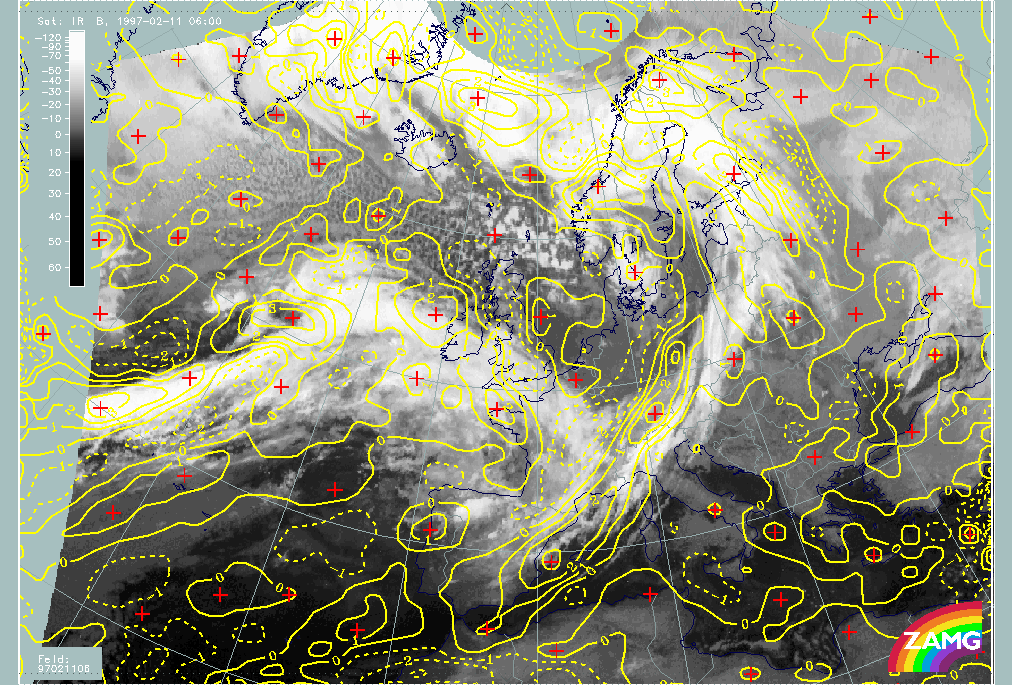
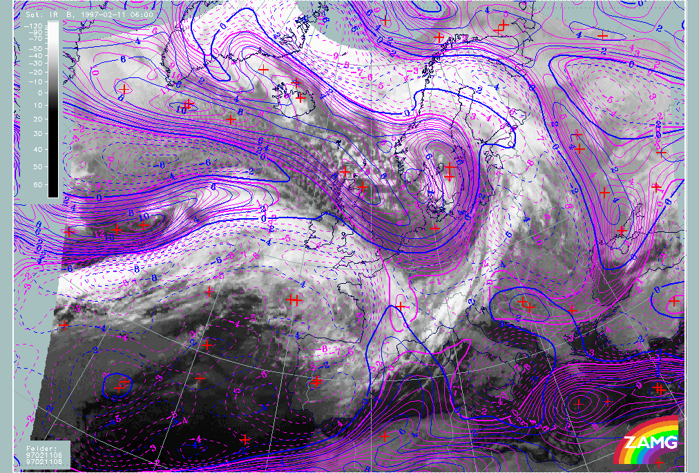
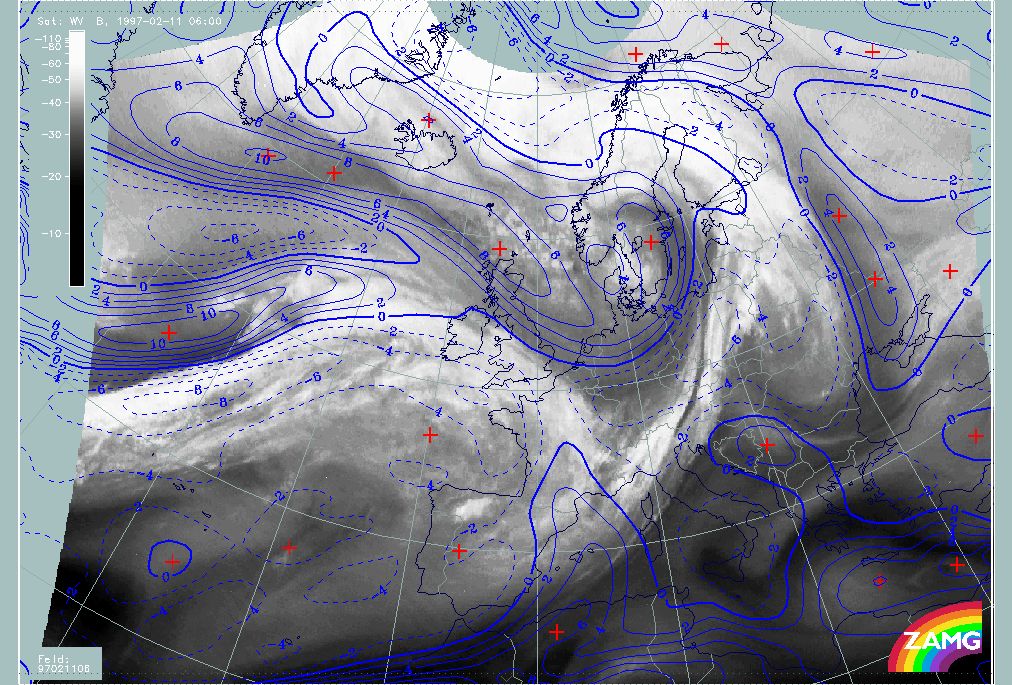
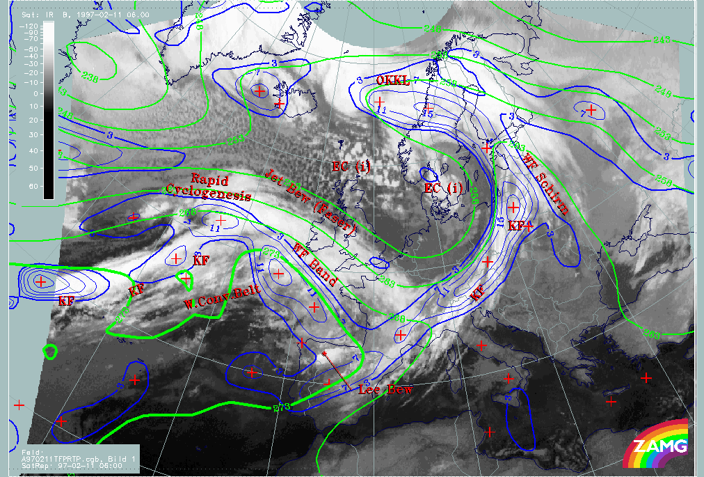
11 February 1997/06.00 UTC - Meteosat IR image; green solid: divergence 1000 hPa, green dashed: convergence 1000 hPa
|

|
|
|
|
|
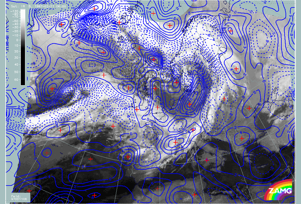
11 February 1997/06.00 UTC - Meteosat IR image; yellow solid: divergence 300 hPa, yellow dashed: convergence 300 hPa
|
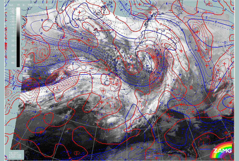
11 February 1997/06.00 UTC - Meteosat IR image; blue dashed: vertical motion (omega) - upward motion 700 hPa, blue solid: vertical motion (omega) - downward motion 700 hPa
|
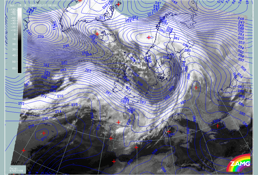
On the right image top the field of divergence at 1000 hPa is superimposed; on the left image bottom divergence at 300 hPa; dashed lines represent convergence, solid lines divergence. The right image bottom contains upward motion at 700 hPa with the dashed lines representing upward, the solid lines downward motion.
There are several big convergence areas at the surface level representing the lower boundary of the circulation cell; they are connected with the following cloud systems (left image top):
- The Cold Front cloud band named "KF" over the Atlantic;
- The Warm Front cloud band named "WF Band" over the Atlantic and the British Isles containing a double structure;
- The Cold Front cloud band named "KF" reaching from E. Austria to the Baltic states and called further the Central Europe Cold Front;
- The Enhanced Cumuli area named EC(i) over Denmark and south Sweden;
- The sequence of cloud bands and cloud spirals between Greenland and Norway;
- The cloud spiral in an area of Rapid Cyclogenesis (named Rapid Cyclogenesis).
Compared to the divergence field at 300 hPa (left image bottom) representing the upper level of the circulation cell the following results can be summarized: All the cloud systems just mentioned are accompanied by divergence at this high level. So in the frontal areas as well as in the area of the EC, convergence occurs at low levels and divergence at high levels.
The vertical motion field (lower image) completes the ideas of a circulation cell in these areas:
- Both Cold Front zones show distinct rising;
- In the Warm Front cloud shield only the part west of the British Isles undergoes rising while there is sinking in the eastern parts; this will be discussed in more detail below;
- Very intensive rising appears in the main part of the "Rapid Cyclogenesis".
Looking again at the surface level (right image top) several big areas are accompanied by divergence indicated by the solid lines; they are connected with the following cloud systems (left image top):
- The area over Germany and Poland representing the cold air behind the Cold Front which contains only little cloudiness;
- The wide area of cold air cloud cells over the Atlantic north and west of the "Rapid Cyclogensis";
- The easternmost part of the warm front over south-east England and France;
- A big part of the cloud head of the "Rapid Cyclogenesis".
Compared to the 300 hPa level (left image bottom) nearly all areas just mentioned are areas of convergence at high and divergence at low levels. This can be interpreted as a reverse circulation cell with downward motion in the troposphere between these two boundaries.
The vertical motion image (low panel) supports this idea with the solid lines representing downward motion.
- This is in best agreement with the basic concept of downward motion in the cold air streams behind the frontal zones.
- The eastern part of the Warm Front cloudiness over south-east England and France shows a change of cloudiness from this to the next images which show that only high cloudiness is left.
- The situation in the cloud head area of the "Rapid Cyclogensis" cannot be interpreted so easily and needs deeper investigation; maybe for the highest clouds in the cloud head vertical motion at 700 hPa is not representative.
|
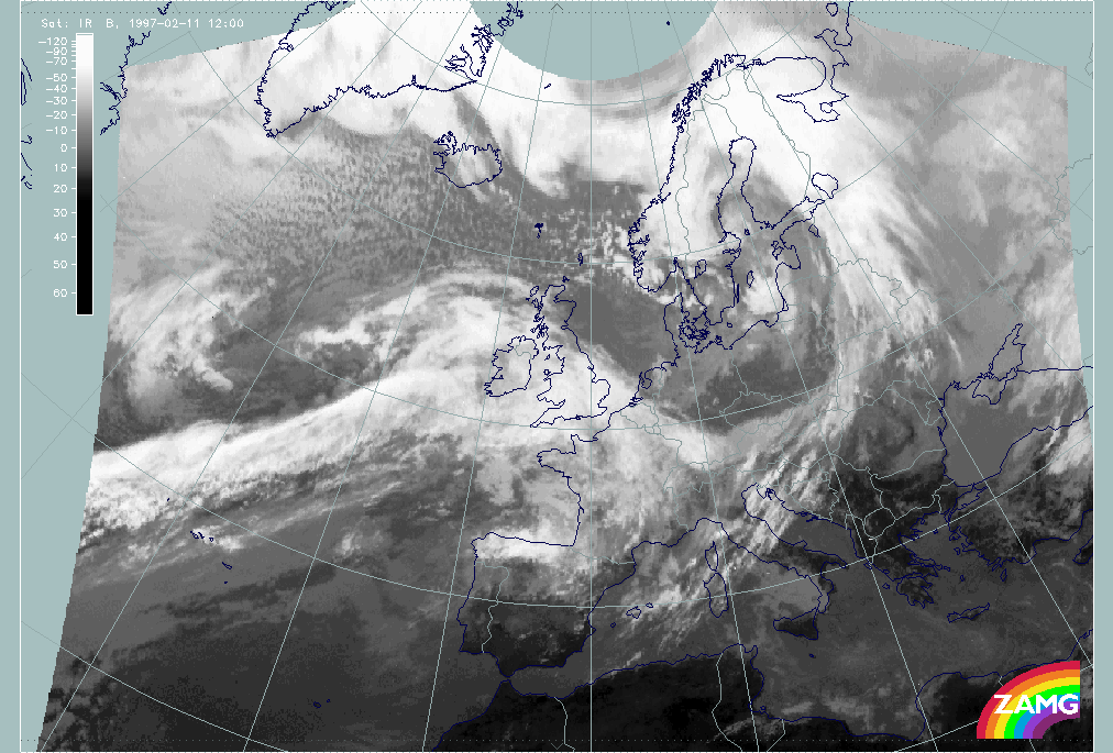
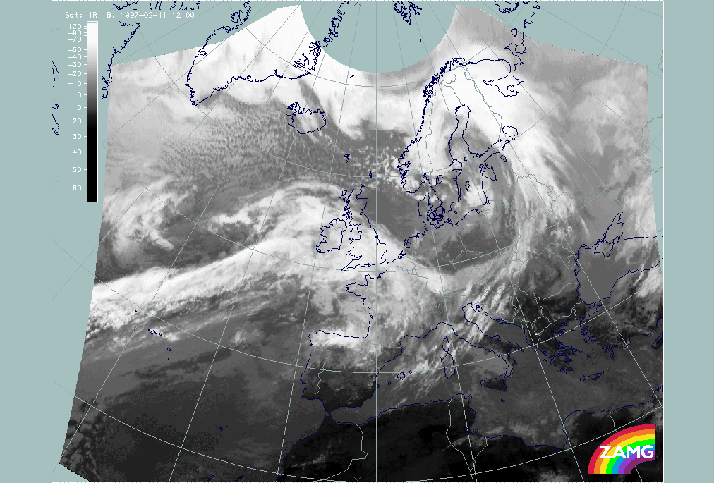
11 February 1997/12.00 UTC - Meteosat IR image
|
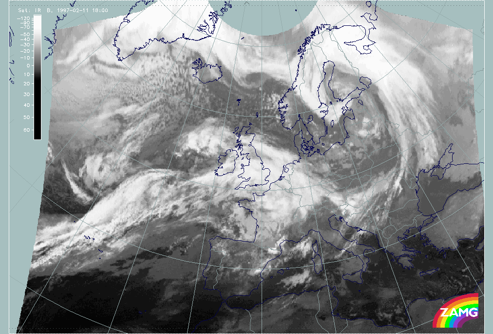
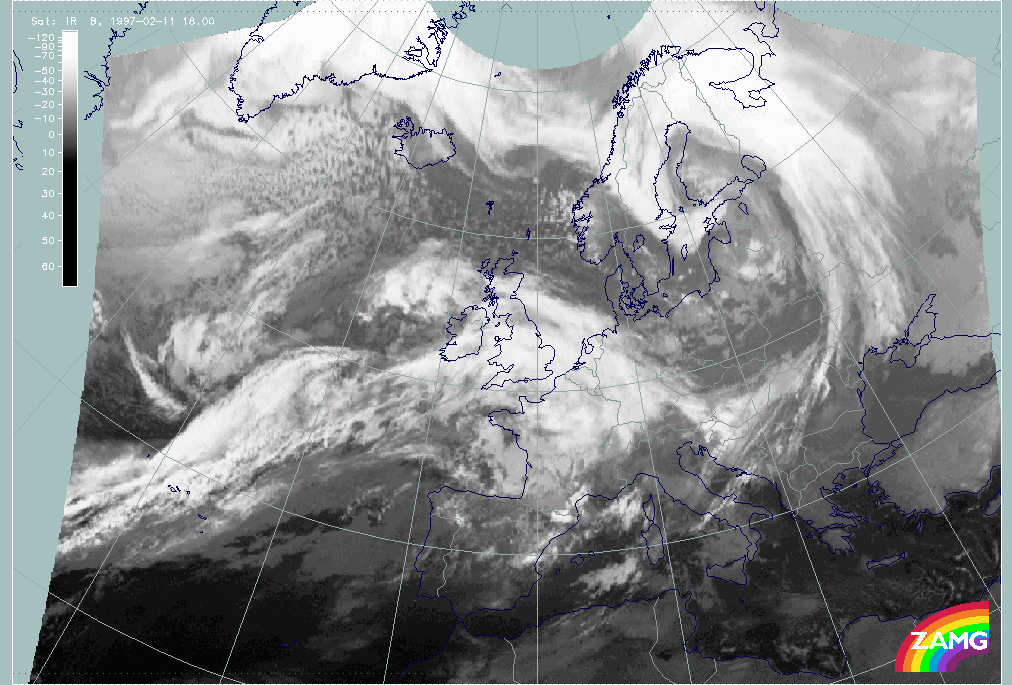
11 February 1997/18.00 UTC - Meteosat IR image
|
|
|
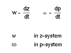
Vertical Motion - Omega Equation
The main meteorological parameter responsible for the production of cloudiness when there is sufficient humidity is vertical motion:
The vertical motion has a theoretical connection to other meteorological parameters, which individually may be indicative of special cloud areas and configurations. The resulting values of vertical motion expressed as omega are a composite of several processes; this is mathematically described in the omega equation. Satellite meteorology has shown that not only the resulting complete omega field fits to cloud systems but that single contributors are connected with different cloud configurations which are characteristic of the different processes. Therefore even the analysis of these single parameters can be a valuable tool for satellite meteorology.
The equation below is a presentation of the omega equation where the connection between the contributions to vertical motion and the characteristic cloud configurations can be discriminated.
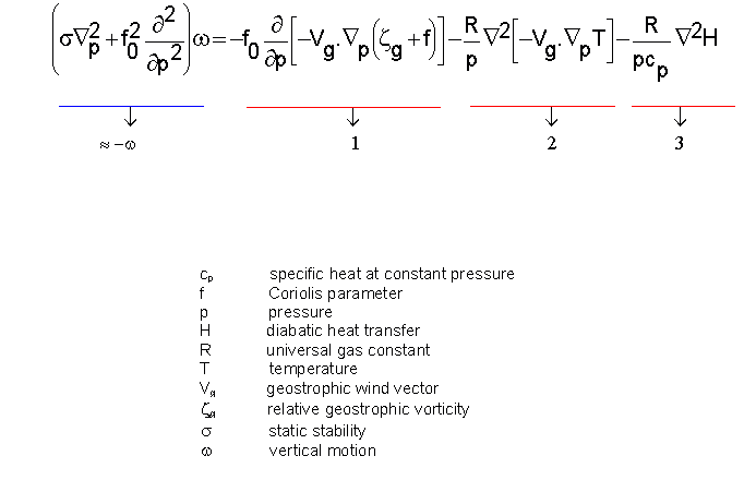
- Term (1) contains the vertical variation of Vorticity Advection (see Vorticity and Vorticity Advection).
- Term (2) contains the Laplace operator of Temperature Advection (see Temperature Advection).
- Term (3) contains the Laplace operator of diabatic heat change. Term (3) will not be addressed further; since it is related to term(1) and (2) forcing's and local convection.
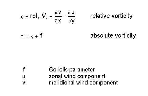
Vorticity and Vorticity Advection
Development of spiral structures and the interaction of vorticity and vorticity advection
As already described in the chapter Vertical Motion - Omega Equation vorticity describes the rotation of a flow field, and is, therefore, a divergence property of the flow.
The influence of cyclonic vorticity on an originally unformed cloud field can be shown easily:
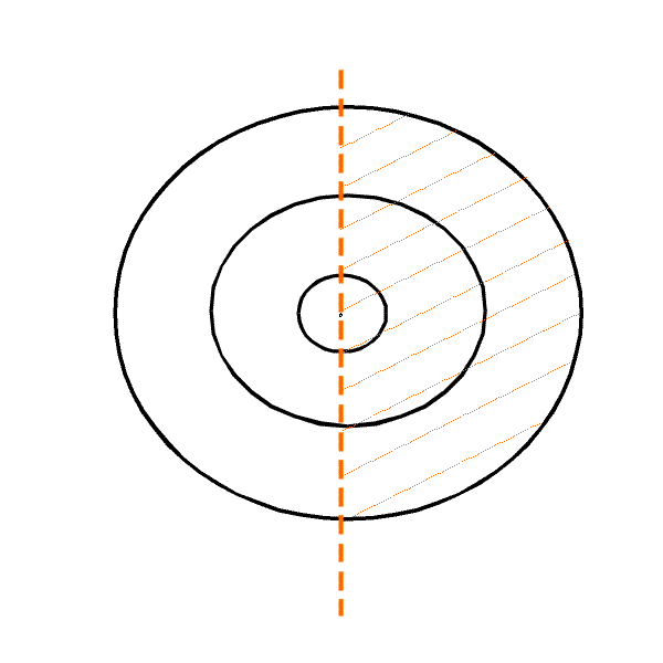
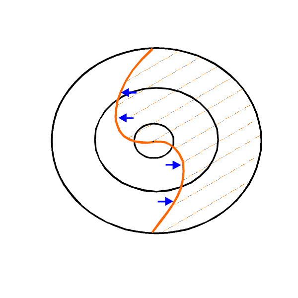
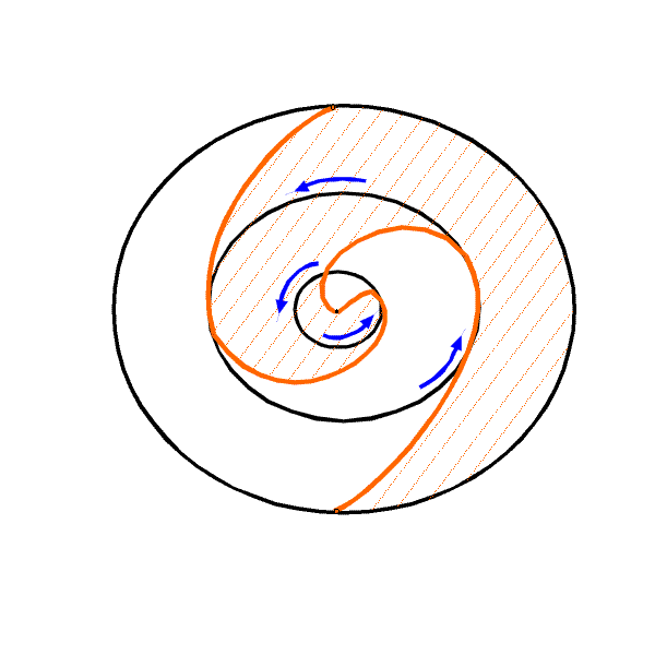
Solid magenta lines represent a maximum of cyclonic circulation where the values are maximum in the centre and decrease to the outermost boundary. Whilst in the centre and at the boundaries no rotation acts on the cloud field, the rotation in between is such that the cloud field develops a distinct spiral structure after a period of time. Consequently a clear interaction between the cloud-forming parameters of vorticity and vorticity advection can be observed:
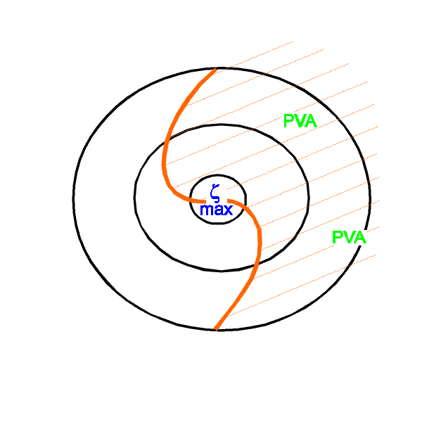
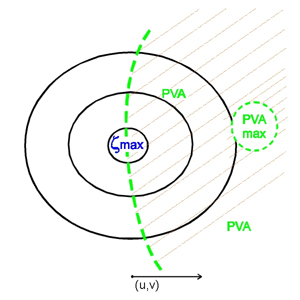
If cyclonic vorticity exists within an air stream it is transported within this stream which leads to the development of a maximum of vorticity advection (PVA). Assuming sufficient humidity, cloudiness may be produced within the PVA maximum. Once this cloudiness exists the effect of rotation in the vorticity maximum leads to the formation of a spiral structure within this cloud system.
Vorticity consists of two contributing parts which allow an even deeper interpretation of typical cloud systems. These two parts can be distinguished easily if vorticiy is written in a natural coordinate system:
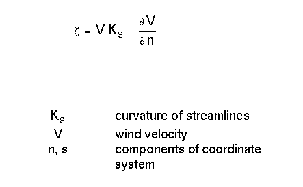
Therefore one part of vorticity originates from the curvature and the other one from the shear of the air flow.
Curvature vorticity
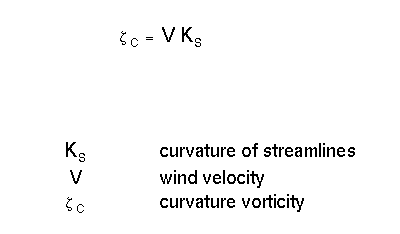
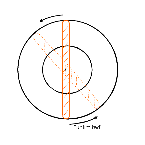
It is quite obvious that a cloud line under the influence of curvature is rotated according to the strength of curvature vorticity. There is theoretically no limit to this rotation. The typical resulting cloud features are:
- Extra tropical low centres
- Commas
- Developing Waves
Shear vorticity
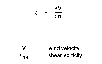
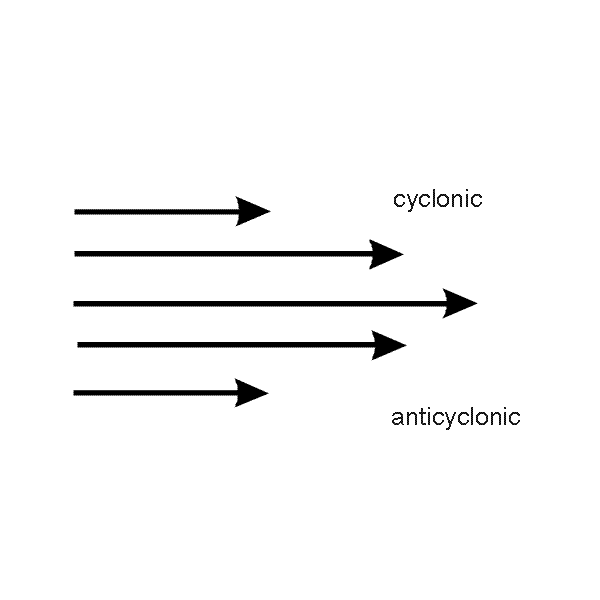
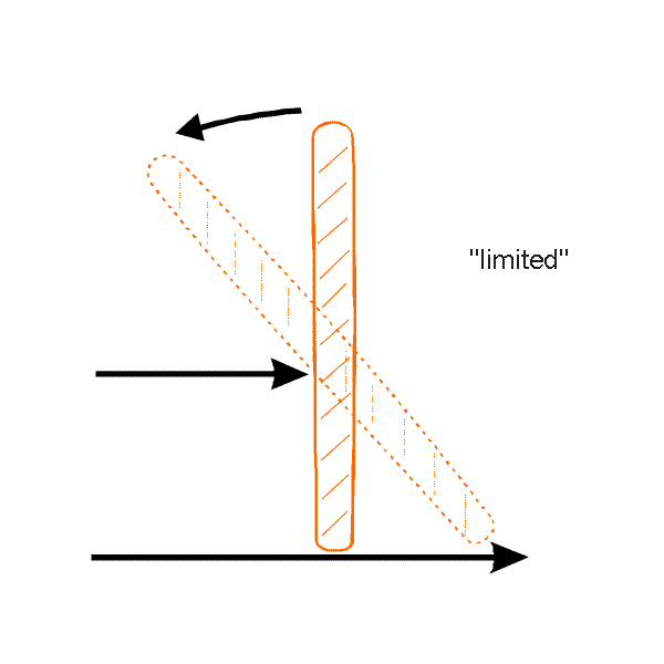
A typical situation where significant shear is apparent within an air stream is a jet stream. It is obvious that a cloud line is rotated in the cyclonic part of shear but, contrary to the effect of curvature the rotation by shear is limited and cannot be large. Consequently, the typical resulting cloud features are Enhanced Cumuli (EC) .
Typical locations for shear and curvature vorticity
Looking at the most common streamline configuration of an upper level trough the following facts can be summarized:
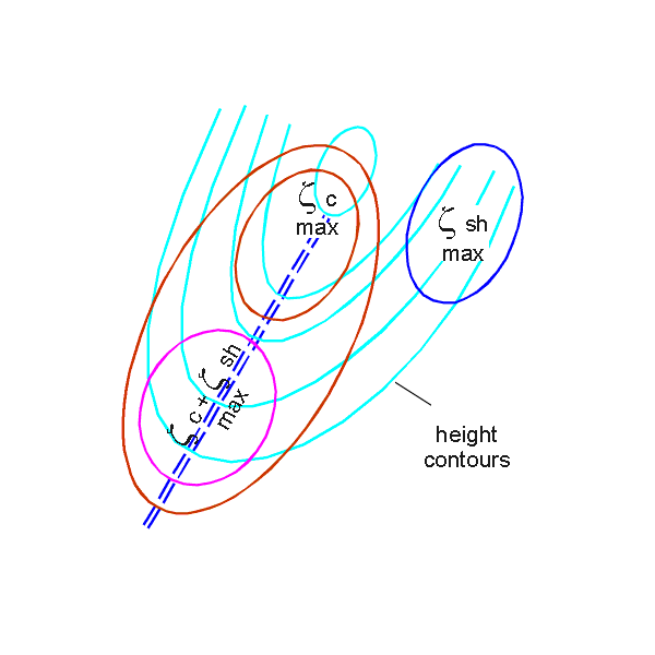
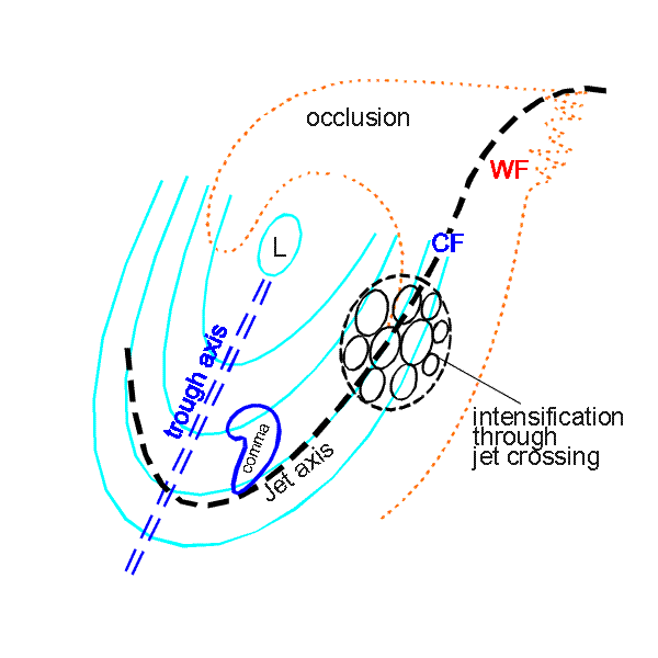
There is maximum curvature vorticity in the low centre as well as in the trough lying to the south-west. But while in the low centre curvature is the dominant feature, contributions to the vorticity in the trough area stem from both parts, curvature and shear. In the areas of the south-west stream in the leading part of the upper level trough streamlines are more rectilinear; consequently shear is the dominant feature there.
Typical cloud configurations associated with such a distribution of streamlines are:
- The main cloud spiral twisting around the low centre
- A Comma configuration immediately in front of the trough line
- Either an EC cloud configuration in the left exit region of a jet streak or the intensification of cloudiness within the front caused by the crossing of the jet streak
The case study of 11 February 1997/06 UTC shows some of the features discussed.
|
11 February 1997/06.00 UTC - Meteosat IR image; magenta: relative vorticity 300 hPa, SatRep overlay: names of conceptual models
|
11 February 1997/06.00 UTC - Meteosat IR image; magenta: relative vorticity 300 hPa, blue: shear vorticity 300 hPa
|
|
|
In the left image relative vorticity at 300 hPa is superimposed. If compared with the image with vorticity at 500 hPa, very similar results can be derived. The only difference can be detected close to the coast east of Scotland, where a vorticity maximum with a closed isoline can be identified.
The right image shows shear vorticity to total vorticity.
There are areas where both fields look very similar and which can be interpreted as situations where shear vorticity provides a large contribution. The following areas should be noted:
- The maximum over Sweden which is to the rear of the Cold Front (over Central Europe)
- The maximum north-east of Scotland
- The maximum behind the Atlantic Cold Front and west of the Rapid Cyclogenesis
- The maximum south-east of Greenland
There are areas where the total and shear vorticity deviate from each other and which can be interpreted as situations where shear vorticity has no big influence on the total vorticity. This means that curvature vorticity must play the more important role. The following areas should be noted:
- The vorticity maximum over Poland and Germany behind the Cold Front where shear vorticity does not have the shape of a maximum but, on the other hand, a big part of the cyclonic vorticity is accompanied by anticyclonic shear vorticity;
- A similar situation, but less distinct, can be seen on the westernmost boundary of the image panel to the rear of the Atlantic Cold Front;
- The area near Iceland, where the maxima in the two vorticity fields are shifted relative to each other.
The following image has a third parameter, curvature vorticity, added.
|
11 February 1997/06.00 UTC - Meteosat IR image; magenta: relative vorticity 300 hPa, blue: shear vorticity 300 hPa, SatRep overlay: names of conceptual models
|
11 February 1997/06.00 UTC - Meteosat IR image; magenta: relative vorticity 300 hPa, brown: curvature vorticity 300 hPa, SatRep overlay: names of conceptual models
|
|
|
As before areas where all three parameters have a similar shape can be recognized and interpreted as areas where shear and curvature contribute equally to vorticity:
- The maximum over south Sweden behind the Cold Front over Central Europe
- The maximum over the Atlantic west of the Rapid Cyclogenesis (approximately 48N/33W) although in this case curvature is much weaker than shear
Areas where curvature vorticity deviates from shear vorticity but is very similar to the total vorticity field can be interpreted as areas where curvature is the dominant feature:
- The maximum over Poland and Germany behind the Cold Front over Central Europe
- The area close to the westernmost image panel boundary on the rear side of the Atlantic front
Areas where curvature vorticity deviates from the shape of shear and total vorticity can be interpreted as areas where shear plays the dominant role:
- The maximum north-east of Scotland which is rather weak in the curvature part
|
11 February 1997/06.00 UTC - Meteosat IR image; brown: curvature vorticity 300 hPa, red: positive vorticity advection (PVA) 300 hPa
|
11 February 1997/06.00 UTC - Meteosat IR image; blue: shear vorticity 300 hPa, red: positive vorticity advection (PVA) 300 hPa
|
|
|
With this deeper insight into the physical situations existing in the troposphere, even PVA maxima can be explained in terms of these situations and, hence, already provide hints to differentiate between individual conceptual models. In the demonstration case the following diagnoses can be made:
- There are two PVA at the rear of the Cold Front over Central Europe; while the northern one over the Baltic Sea originates from a vorticity maximum consisting of both shear and curvature, the southern one over Poland is the result of a moving trough; shear is even anticyclonic there
- The PVA maximum over the North Sea indicates a moving shear vorticity maximum; the associated increased cellular cloudiness is typical for the left exit region of a jet streak
- The strong PVA maximum in the region behind the Rapid Cyclogenesis is again related to a PVA maximum which consists of both shear and curvature, however, but shear is still dominant; this is a typical conceptual model of Rapid Cyclogenesis which develops in the left exit region of a jet streak where frontogenetic conditions exist whilst in classical Wave development increasing curvature is the parameter
- The PVA maximum to the rear of the Atlantic Cold Front, close to the western boundary of the image, is an example of such a Wave development. It indicates the propagation of a curvature vorticity maximum (shear is very weak there); the following images for 12.00 and 18.00 UTC (see below) show that in this area increased cloudiness is indeed indicative of a wave development: at 12.00 UTC the cloud bulge can be seen at 44N/31W, at 18.00 UTC close to 49N/25W
|
11 February 1997/12.00 UTC - Meteosat IR image
|
11 February 1997/18.00 UTC - Meteosat IR image
|
|
|
Shear vorticity at 300 hPa is also a very valuable tool to identify jet axes. Jet streams are characterized by a core of strong winds which decrease in speed to both sides leading to a cyclonic shear area on the left and an anticyclonic shear area to the right (looking in the direction of the stream). This can be described by the zeroline of shear vorticity. Another valuable tool for indicating jet axes are WV images. They show distinct elongated Black Stripes which represent sinking dry tropospheric or even stratospheric air streaming along the left or cyclonic side of the jet axis; the grey shaded bands to the right of these black strips represent the ascending warmer, more humid air on the anticyclonic side.
|
11 February 1997/06.00 UTC - Meteosat WV image; SatRep overlay: names of conceptual models
|
11 February 1997/06.00 UTC - Meteosat WV image; blue: shear vorticity 300 hPa
|
|
|
In the WV image of the case in question (left image), the following Black Stripes can be seen:
- Over Poland and Germany behind the Cold Front; there is a distinct structure from about 51N/10E to 52N/15E and 55N/16E;
- Over the northern Atlantic from about 55N/40W to 61N/20W and further across Scotland to the Netherlands where it is connected with the structure mentioned above;
- Ahead of the Rapid Cyclogenesis from about 50N/37W to 56N/28W;
- To the rear of the Atlantic Cold Front from about 40N/40W to 48N/29W where it forms a very broad area.
Consequently, the combination of both sets of information, the Black Stripes in the WV image and the zeroline of shear vorticity in the numerical model field can give more complete information about the existence of the jet streams and the location of the jet axes. Such a combination is also a tool to detect model analysis errors.
In the demonstration case (right image) the following can be observed:
- There is a jet branch on the north-western Atlantic (compare the second point above) with the zeroline of shear vorticity close to the WV boundary and cyclonic shear on the left and anticyclonic shear on the right side; but the model zeroline deviates east of 20W southward from the WV structure; this may have its cause in the second main jet stream with the axis close to the back side of the Atlantic front;
- Also for this case the zeroline of shear vorticity with cyclonic values on the left and anticyclonic values on the right side fits relatively well to the black area in the WV image with two smaller exceptions: a deviation of the zeroline to the north close to the western boundary of the image and a deviation to the south at about 55N/15W. Both deviations cannot clearly be decided as a model error because such a far developed situation causes also some difficulties in an exact location from the WV image alone, but it seems to be obvious that the model cannot discriminate between the two jet branches over the British Isles and does not indicate the northern one over Scotland;
- The zeroline of shear vorticity over Germany and Poland closely follows the structure mentioned under the first point above and can be regarded as correct;
- The Black Stripe north of the cloud head of Rapid Cyclogenesis (mentioned under the third point above) is not typical of a jet situation when one notices that in the western jet streak the signs of cyclonic and anticyclomic shear vorticity appeared to be reversed.
This description is valid for the Northern Hemisphere as the rotation in the Southern Hemisphere is the other way around the signs of the values are also to the opposite.
Potential Vorticity
Definition and characteristics of Potential Vorticity
The potential vorticity (PV) is the absolute circulation of an air parcel that is enclosed between two isentropic surfaces. If PV is displayed on a surface of constant potential temperature, then it is officially called IPV (isentropic potential vorticity). Of course, PV could also be displayed on another surface, for example a pressure surface. Note from the relation below, that PV is simply the product of absolute vorticity on an isentropic surface and static stability. So PV consists, in contrast to vorticity on isobaric surfaces, of two factors, a dynamical element and a thermodynamical element.
Within the troposphere, the values of PV are usually low. However, the potential vorticity increases rapidly from the troposphere to the stratosphere due to the significant change of the static stability. Typical changes of the potential vorticity within the area of the tropopause are from 1 (tropospheric air) to 4 (stratospheric air) PV units (10-6 m2 s-1 K kg-1). Today in most of the literature the 2 PV unit anomaly, which separates tropospheric from stratospheric air, is referred to as dynamical tropopause. The traditional way of describing the tropopause, is with use of the potential temperature or static stability. This is only a thermodynamical way of characterising the tropopause. The benefit of using PV is that the tropopause can be understood in both thermodynamic and dynamic terms. An abrupt folding or lowering of the dynamical tropopause can also be called an upper PV-anomaly. When this occurs, stratospheric air penetrates into the troposphere resulting in high values of PV with respect to the surroundings, creating a positive PV-anomaly. In the lower levels of the troposphere, strong baroclinic zones often occur which can be regarded as low level PV anomalies.
It must be stressed that this other way of looking at the dynamics of the atmosphere will not necessarily result in new conclusions. However, it may give new dimensions to things that in fact were already known.
The two main advantages of potential vorticity (with certain assumptions) are:
- Conservation
- Invertibility
The two advantages will be discussed briefly:
Conservation
With the following assumptions PV is a conserved parameter
- Adiabatic stream (no diabatic heating or cooling)
- No friction
- Homogenous
- Non-compressing
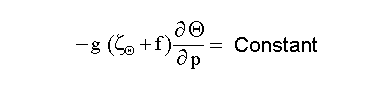
A first mathematical consequence of the conservation can be derived from the definition of PV: A parcel will keep the same value of PV if it moves along an adiabat through the atmosphere thus the equation for PV can be written as:
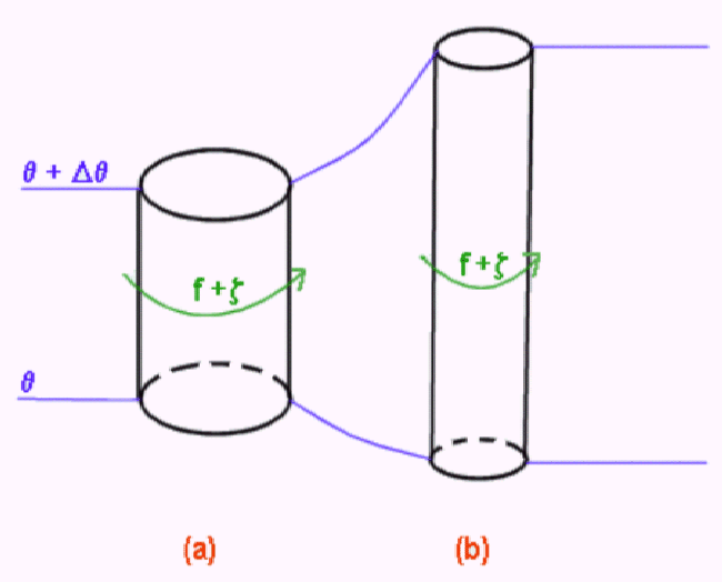
Due to the conservation of PV, there is a close relationship between absolute vorticity and static stability. The diagram below shows a cylinder with the top and bottom defined by two isentropic surfaces. Difference in potential temperature between the top and bottom is the same for the two cylinders. If PV is conserved, and the cylinder is stretched as shown in (b), then static stability is decreasing and absolute vorticity must increase. Alternatively, if one goes from (b) to (a), then static stability is increasing and absolute vorticity must decrease.
Due to the conservation of PV, significant features that are related to synoptic scale weather systems can be identified and followed in space as well as in time. This is a very powerful characteristic of this property. Especially the case of a lowering of the dynamical tropopause, the upper PV - anomaly can be followed in time and space rather easily. PV anomalies are well related to a lot of dynamical processes in the troposphere. A distinct example of this are cases of Rapid Cyclogenesis where PV - anomalies play an important role.
The sudden creation or destruction of PV means that diabatic processes are involved (release of latent heat, friction, radiation). This fact can be used as tool to identify or even quantify the influence of these processes.
Invertibility
The second advantage of PV, invertibility, is a very important tool, because it allows one to obtain familiar meteorological fields, like the geopotential, wind, temperature and the static stability, when the distribution of the PV and the boundary conditions, potential temperature at the surface, are known. Further with the help of the invertibility it is possible to quantify the importance of PV-anomalies and the strength of their associated circulation and/or temperature pattern.
Potential Vorticity and Water Vapour imagery
There is a clear relation between PV and water vapour imagery. A low tropopause can be identified in the WV imagery as a dark zone. As a first approximation, the tropopause can be regarded as a layer with high relative humidity, whereas the stratosphere is very dry, with low values of relative humidity. The measured radiation temperature will increase if the tropopause lowers. This is because of the fact that the radiation, which is measured by the satellite, comes as a first approximation from the top of the moist troposphere. High radiation temperatures will result in dark areas in the WV imagery. The upper PV-anomaly and its appearance in the WV imagery can have different shapes, which is illustrated in the schematics below.
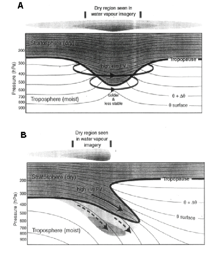
Situation (a) is the appearance in WV imagery in case of a circular cyclonic upper level PV - anomaly. In the WV image this anomaly is represented as a black shaded area which gradually becomes grey at the edges. Typical examples are WV eyes (compare Water Vapour Vortices ).
Situation (b) is the appearance in the WV imagery in the case of a frontal zone. Most striking here is the shape of the PV-anomaly: The tropopause has been folded in this situation. This can be seen as a discontinuity in the pixel values of the WV imagery. So a sudden change from low to high pixel values can be expected. Typical examples are dark stripes (compare Dark Stripes). In the situation shown below, an example of a sudden change in pixel value can be seen in the red rectangle.
PV fields can also be used to detect the discrepancies between numerical models and observations because of the tight relationship between PV and WV.
More structure than isobaric analyses
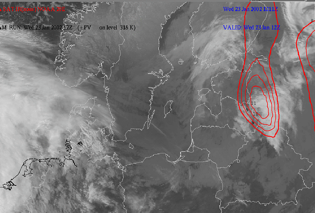
Analyses of PV appear to have more structure than height analyses on an isobaric surface. The reason for this is a mathematical consequence of the dynamical principles. The horizontal gradient of PV is related to the second derivatives of the wind field with respect to both the horizontal and the vertical co-ordinate variables. The wind field is thus the inverse Laplacian of the derivative of the PV field. Since the laplacian acts as a smoother, the wind field must be smoother than the PV gradient field. If the gradient wind formula is examined, one can establish that the wind is related to the gradient of the geopotential height. Therefore the PV field is related to second derivatives of the geopotential height, and must show a lot more structure than the geopotential height field. The practical consequence is that using PV can identify e.g. short wave troughs in the geopotential height field more easily. Since fast-moving troughs can influence weather dramatically, PV is a useful tool to notify this kind of small-scale structures.
|
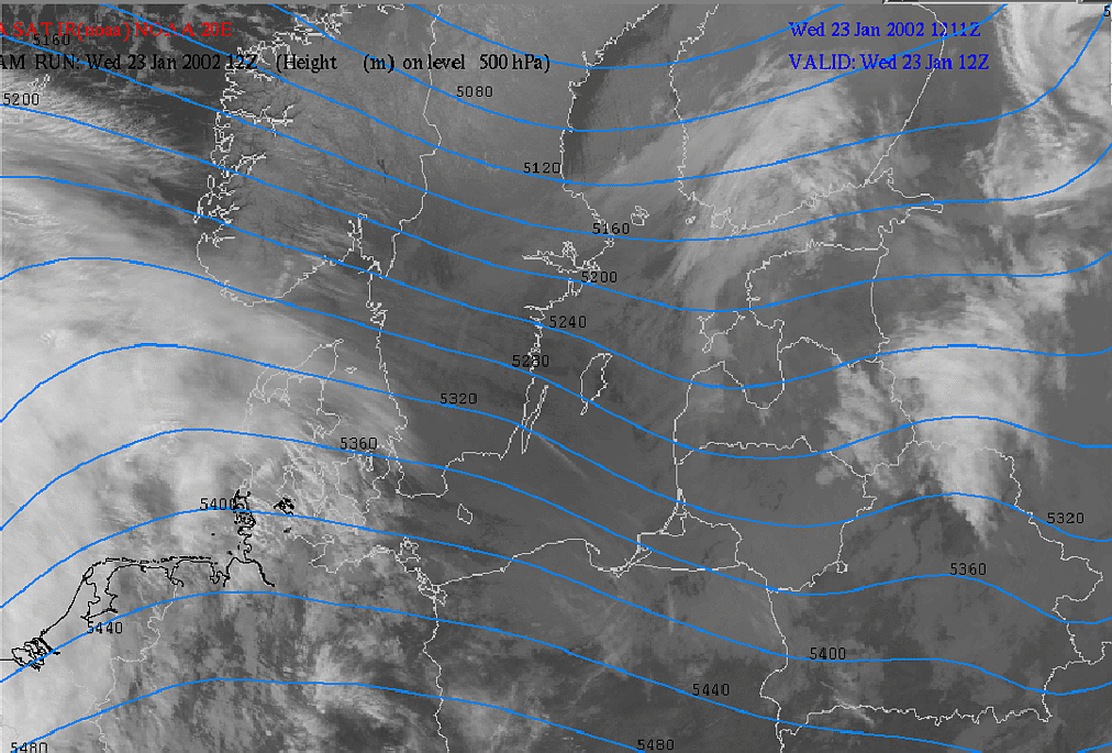
23 January 2002/12.00 UTC - NOAA IR image (channel 4); blue: geopotential height 500 hPa
|
23 January 2002/12.00 UTC - NOAA IR image (channel 4); red: potential vorticity 318K
|
|
|
The left image above shows a small trough over the Baltic States in the geopotential height field at 500 hPa. It can be seen that the trough coincides with an enhanced cloud feature just ahead of the trough axis. The PV field in the right image shows that this small trough is accompanied by a very distinct PV maximum in front of it.
PV-Anomalies
In the previous chapters, it has been mentioned that a lowering of the tropopause is called an upper level PV-anomaly. These anomalies are characterised in the WV imagery as dark shaded areas, which can occur with different shapes. It has also been noted that the PV field induces all other meteorological fields because of the invertibility principle. The characteristics of an upper-level PV anomaly are now examined in more detail. Therefore a cross section through an idealised cyclonic eddy will be examined:
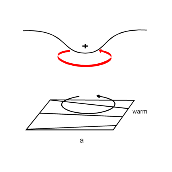
Under the assumption of a three dimensional balance between the fields of mass, pressure and wind, positive PV anomalies are connected with cyclonic vorticity and negative PV anomalies with anticyclonic vorticity.
- In the case of a positive PV anomaly, the isentropes are characterised by higher values than in the surrounding areas (indicating colder air). The height of the tropopause has a local minimum. The corresponding pressure and wind field shows an area with low pressure and a cyclonic circulation.
- In the case of a negative PV anomaly, the isentropes are characterised by lower values than in the surrounding areas (indicating warmer air). The height of the tropopause has a local maximum. The corresponding pressure and wind field shows an area with high pressure and an anticyclonic circulation.
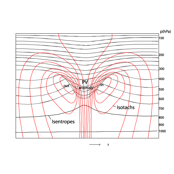
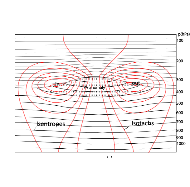
From the diagrams above it can be seen that an upper PV-anomaly is perturbing the wind and pressure fields throughout the whole depth of the troposhere. The effect of the perturbation is proportional to the horizontal scale of the anomaly and inversely proportional to static stability (see the PV equation).
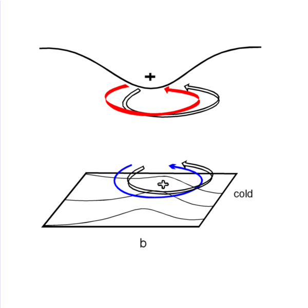
Investigations have also shown the existence of low level PV-anomalies These anomalies do not have stratospheric origin but are being formed in strong baroclinic zones where much release of latent heat takes place. However, these PV-anomalies are frequently invisible in satellite imagery. But, recent studies have shown their existence in both observations and model fields. For a closer look at the characteristics of a low-level PV-anomaly a cross section through an idealised cyclonic eddy is examined:
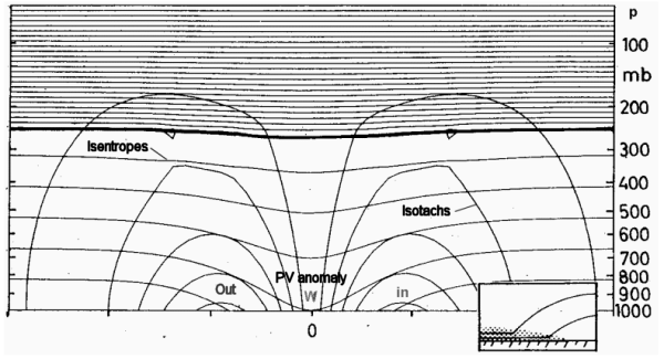
In the case of a positive PV anomaly, the isentropes are characterised by higher values than the surroundings. Therefore the isentropes have to curve downwards because, in general, potential temperature increases with height. The corresponding pressure and wind field show an area with low pressure and a cyclonic circulation.
In an idealised anomaly, the isentropes do not stop at the surface but follow the surface closely at the low levels. This can be seen in the embedded enlargement in the schematic above. Therefore, near the earth's surface the static stability is relatively high, as is the potential vorticity. Due to the thermal gradients on both sides of the anomaly there must be a wind maximum at the level where the anomaly has its maximum. This is a consequence of the thermal wind which implies that vertical wind gradients and horizontal temperature gradients are related. The wind field throughout the whole depth of the troposphere can be induced by a low-level PV - anomaly. This idea is actually analogous to the concept of the upper level PV-anomalies.
The material conservation, combined with the advantage of invertibility is very useful to describe complex dynamic processes. For example Rapid Cyclogenesis, and other conceptual models can be described using PV. Research indicates that Rapid Cyclogenesis can be explained by an interaction between low and upper level PV-anomalies. When the phase difference between two PV-anomalies has an optimum value, interaction followed by mutual amplification takes place. Of course the opposite can also occur, in the case of decaying cyclones.
If an upper level PV-anomaly develops, then as a consequence of the PV equation, positive vorticity is released and high PV values from the stratosphere influence the less stable environment of the troposphere. The assumption for the figures above is that that an upper-level, positive PV-anomaly is being advected over a zone of strong, low-level equatorward temperature gradient describes a situation where an originally small-scale upper level trough moves over a zonally oriented surface Cold Front. The left figure (a) shows such a situation with the solid + sign indicating the upper level PV-anomaly.
The thick solid arrow around the PV maxium indicates the cyclonic rotation. This rotation is induced at lower levels of the baroclinic zone as shown by the thin solid circulation arrow. This low level circulation causes warm advection ahead leading to a low level positive temperature anomaly indicated by the open + sign in the right figure (b). This temperature anomaly is associated with a cyclonic vortex which is marked by the open arrow at low levels.In turn, this circulation has a positive feedback to the upper troposphere, shown by an open circulation arrow at higher levels.
In parallel a second process is taking place: The induced low level vortex results in a strong equatorward wind component under the upper level PV anomaly. This southward component also influences the higher levels and leads to an equatorward advection of the upper level PV-anomaly which in turn intensifies the upper level Wave.
Within this increased flow higher PV values to the west of the PV-anomaly are advected southward and lower PV values to the east of the PV-anomaly are advected northward. As a consequence of the latter process, the eastward movement of the PV-anomaly is decreased. Hence, the interaction between low and upper level circulations and the already ongoing cyclogenesis process will strengthen.
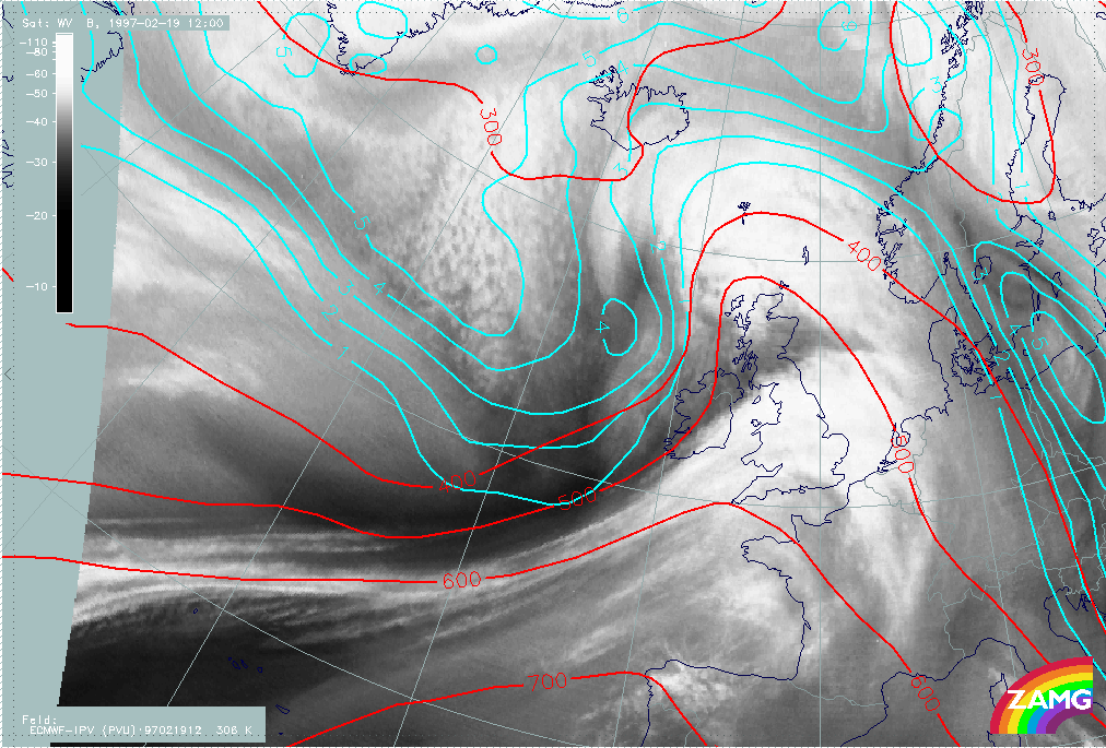
Example
|
19 February 1997/12.00 UTC - Meteosat WV image; cyan: potential vorticity 306K; red: isobars
|
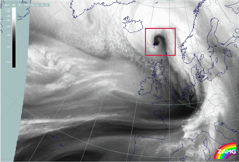
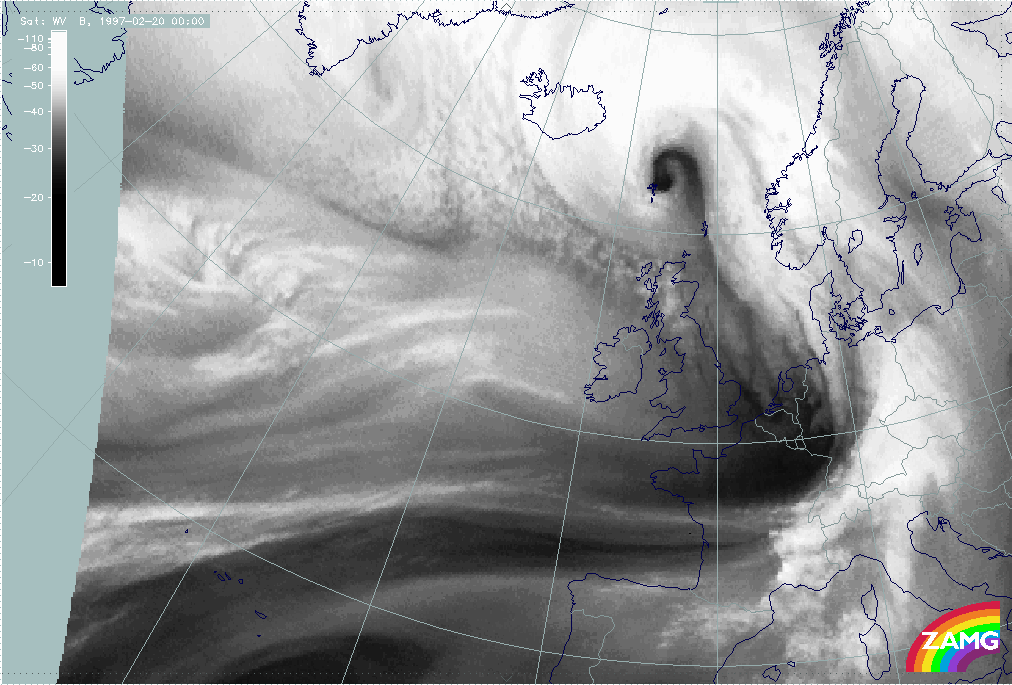
20 February 1997/00.00 UTC - Meteosat WV image
|
|
|
The left image above shows the cloud band of a cold front extending from the Atlantic towards Scotland. The corresponding Warm Front cloudiness is situated above the North Sea, the Netherlands, Belgium and the eastern part of France. The cloudiness east of Scotland is the cloud head of a rapid cyclogenesis. The cloud head can be separated into two parts: a south-eastern one situated above Scotland and the Faroe Islands, and a north-west one extending from the Atlantic at approximately 58N/18W to Iceland.
The values of the PV are characterised, as described above, by increasing values from south to north. The anomaly of the PV, the area where the vorticity has two units (dynamical tropopause or separation between tropospheric and stratospheric air), can be found within the north western area of the cloud head. In contrast, the southeastern part of the cloud head is characterised by values of isentropic potential temperature below 1 unit (tropospheric air). The consequence of this distribution is that there will be a cyclonic development of the northwest cloud head, but no further development of the southeastern one.
For verification the right image above shows the meteorological situation 12 hours later. The northwestern part of the cloud head has moved during the last 12 hours towards a location east of Iceland. The rest of the southeastern part can be found within the area of the Norwegian Sea west of Norway at approximately 64N/08W. While there has been a strong pronounced cyclonic development of the northwest part (cloud head with the anomaly of PV=4 units at 12.00 UTC), there has been no development of the southeastern part of the cloud head.
This description is valid for the Northern Hemisphere as the rotation in the Southern Hemisphere is the other way around the signs of the values are also to the opposite.
References
- AMBAUM M. H. P. (1997): Over daken en muren in de atmosfeer. De Tropopauze; Meteorologica 2-97
- AMBAUM M. H. P. (1997): Isentropic information of the tropopause; J. Atmos. Sci., Vol. 54, p. 555 - 568
- BROWNING K. A.: The dry intrusion perspective of extra-tropical cyclone development; JCMM, Dept. of Met., University of Reading, UK
- CARROLL E. B. (1997): Use of dynamical concepts in weather forecasting; Met. Appl. 4, Vol. 4, p. 345 - 352
- CARROLL E. B.: A technique for consistent alteration of NWP output fields; Met. Off. Bracknell, UK
- CARROLL E. B.: Poorly forecast trough disruption shown in water vapour images; Met. Off. Bracknell, UK
- CONWAY B. J., GERARD L., LABROUSSE J., LILJAS E., SENESI S., SUNDE J. and ZWATZ-MEISE V. (1996): COST78 Meteorology - Nowcasting, a survey of current knowledge, techniques and practice - Phase 1 report; Office for official publications of the European Communities
- COOPER I. M., THORPE A. J. and BISHOP C. H. (1992): The role of diffusive effects on potential vorticity in fronts; Quart. J. R. Meteor. Soc., Vol. 118, p. 629 - 647
- DANIELSEN E. F. (1990): In defense of Ertel' s potential vorticity and its general applicability as a meteorological tracer; J. Atmos. Sci., Vol. 47, p. 2013 - 2020
- DEBRUIN H., SARABER M. and DEBRUIN J. (1997): Potential Vorticity; EuroMet training course on the Internet
- DIEPEVEEN (2000): Analyse van de tweede kerststorm 1999 met behulp van potentiële vorticiteit. Doctoraalscriptie.
- DEMIRTAS M. and THORPE A. J. (1997): Sensitivity of short-range weather forecasts to local potential vorticity modifications; JCMM - internal report 71
- HOSKINS B. J., MCINTYRE M. E. and ROBERTSON A. L. W. (1985): On the use and significance of isentropic potential vorticity maps; Quart. J. R. Meteor. Soc., Vol. 111, p. 877 - 946
- HAYNES P. H. and MCINTYRE M. E. (1990): On the conservation and impermeability theorems for potential vorticity; J. Atmos. Sci., Vol. 47, p. 2021 - 2031
- KNUT H. M. and ROSTING B.: Some elements of dynamic meteorology. Introduction; Norw. Met. Int. Oslo
- KURZ M. (1990): Synoptische Meteorologie - Leitfäden für die Ausbildung im Deutschen Wetterdienst; 2. Auflage, Selbstverlag des Deutschen Wetterdienstes
- MANSFIELD D. A. (1996): The use of potential vorticity as an operational forecast tool; Met. Appl., Vol. 3, p. 310 - 340
- MCINTYRE M. E. (1998): A Vision of the Future; Updated Still Further, Cent. Atm. Sci. Univ. of Cambridge
- PICHLER H. (1984): Dynamik der Atmosphäre; B.I. Wissenschaftsverlag
- ROSTING B., MIDTBO K. H. and GRONAS S. (1996): NOMEK/EUMETSAT - Numerical Weather Prediction; NOMEK/EUMETSAT Training Course, Copenhagen, Denmark
- ROSTING B. and SUNDE J. (1996): Application of Meteosat WV images in monitoring of synoptic scale cyclogenesis; Proceedings 1996 Meteorological Satellite Data Users' Conference, Vienna, Austria, 16 - 20 September 1996, p. 119 - 126
- ROSTING B., SUNDE J. and KNUT H. M.: Monitoring of NWP models by use of satellite data; Norwegian Met. Int. Oslo
- SARABER M., DEBRUIN J. and DEBRUIN H. (1997): PV point of view; EuroMet training course on the internet
- VERKLEY W. (1995): Een scherpere kijk op de atmosfeer. Potentiele vorticiteit; Meteorologica 3-95
Temperature Advection
There is a contribution to upward motion where:
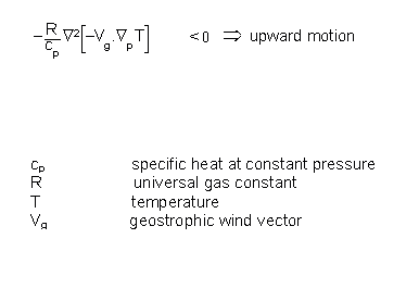
This condition is fulfilled if
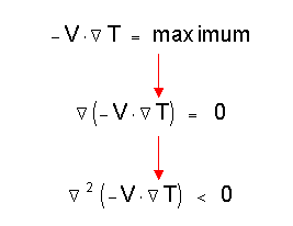
Therefore a contribution to upward motion exists in the maxima of warm advection (WA) which guides an evaluator to look for these maxima in a numerical temperature advection (TA) field.
Typical cloud configurations which are completely or partly connected with this parameter are:
- Warm Fronts
- Conveyor belts
- Cloudiness in thickness ridges
- Waves
- Rapid Cyclogenesis
In contrast, cold advection (CA) contributes to sinking motion and has, therefore, not so much importance in satellite image interpretation. Usually big areas of CA can be found in the areas of cellular cold air cloudiness behind fronts. CA represents the overall downward motion whilst the single cloud cells can be explained in connection with diabatic heat exchange (term 3 in the omega equation (compare Vertical Motion - Omega Equation).
Some practical examples can be found in the test case from 11 February 1997/06.00 UTC.
|
11 February 1997/06.00 UTC - Meteosat IR image; SatRep overlay: names of conceptual models
|
11 February 1997/06.00 UTC - Meteosat IR image; blue: temperature 700 hPa
|
|
|
The following features should to be noted:
- Zones of high temperature gradient (crowded zones of temperature isolines) are connected with frontal cloud bands. They indicate the transition between air masses with different temperatures and can be found in this example with:
- The Cold Fronts ("KF") over the Atlantic and Central Europe:
- The zone of high gradients over the Atlantic is broad possibly indicating two developing frontal zones.
- The zone of high gradients over Central Europe is distinct and partly within, partly behind the cloud band.
- the Warm Front ("WF Band"); the distinct zone of high temperature gradients coincides with the cloud band.
- Ridges indicating high temperatures can usually be found in front of Cold Fronts and in association with occlusion bands where they indicate the lifting of warm air, in agreement with the classical ideas of Occlusion development, and/or the mixing of warm and cold air masses. The following areas are good examples:
- Over the Balkan States and East Europe in front of the Cold Front over Central Europe;
- Over the Atlantic in front of the Atlantic Cold Front and behind the Warm Front;
- From the Baltic States across Finland and Scandinavia into the Norwegian Sea which is associated with the cloud band of an Occlusion (named "OKKL").
- Troughs indicating low temperatures can usually be found behind the frontal zones:
- Over Denmark, Germany and Poland behind the Cold Front over Central Europe.
It will be recalled from the omega equation that it is temperature advection, not temperature, that is the parameter responsible for the development of cloudiness. Therefore both parameters are superimposed on the next image.
Two aspects have to be considered when comparing the two parameters in relation to satellite imagery:
- The relation between temperature at 700 hPa and temperature advection 500/1000 hPa
- The relation of temperature advection to the cloud systems
The following examples can be mentioned:
- Warm advection (WA) can be found in front of the ridge lines of the ridges of high temperature indicating the movement of the warmest air in the ridge line:
- This is very clear for the temperature ridge from the Balkan States across Scandinavia; the main maxima of WA can be found over the Baltic States, Finland and N. Scandinavia;
- Two typical cloud configurations are connected with the WA maxima:
- Warm Front bands or shields (in this case the one named "WF Schirm")
- Occlusion bands (in this case the one named "OKKL")
- The very pronounced WA maximum reaching from Ireland into the Gulf of Biscay indicates the east, north-eastward movement of the warmest air found in the ridge over the Atlantic (approximately 40N/26W - 50N/18W); two cloud configurations are connected with the WA maximum:
- The Warm Front Band ("WF Band") with dense cloudiness
- the Warm Conveyor Belt (labelled "W.Conv.Belt") with more fibrous cloudiness in front of the frontal system; this will be disussed in more detail later under the chapter of relative streams (compare Relative Streams).
- The distinct smaller scale WA maximum in the region of the Rapid Cyclogenesis indicates the advection of the warm air forming the small scale temperature ridge within the frontal crowding zone (approximately 50N/24W - 55N/30W); this WA maximum is connected with secondary cyclogenesis taking place in a Wave development or (as is the case here) within a more rapid development, the Rapid Cyclogenesis
- Cold advection (CA) can be found in front of the cold air troughs starting at the trough line; this indicates the propagation of the coldest air which can be found in the temperature trough. The following examples should be noted:
- Pronounced CA behind the cold front over Central Europe east of the ridge line from Denmark southward to Central France;
- There are only few clouds in the main part of the trough
- The region over the Alpine area is accompanied by frontal cloudiness but with lower cloud tops indicating dissolution of cloudiness from above
- Pronounced CA exists north and north-west of the Rapid Cyclogenesis representing the propagation of the cold air more to the north-west; this is the typical wide area filled with regular cold air cloud cells; they are created where the cold air flows over relatively warm water. Small-scale convective processes are the reason for cloud development but the bigger scale sinking motion restricts the further growing of the cloud cells. Consequently they have warmer cloud tops than the frontal cloud bands.
- A small scale CA area close to the Rapid Cyclogenesis (centred approximately around 48N/27W). There is a typical juxta position of a the initial advection of warm and cold air masses and a strengthening of cyclonic circulation
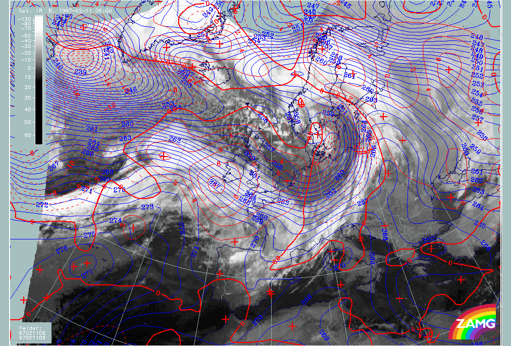
Thermal Front Parameter
A widely used parameter for frontal analysis in the manual as well as in the case studies is the Thermal Front Parameter (TFP). The mathematical definition of the TFP is:
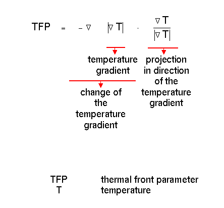
The first factor describes the change of the temperature gradient, the second factor describes the projection of the first term in the direction of the temperature gradient.
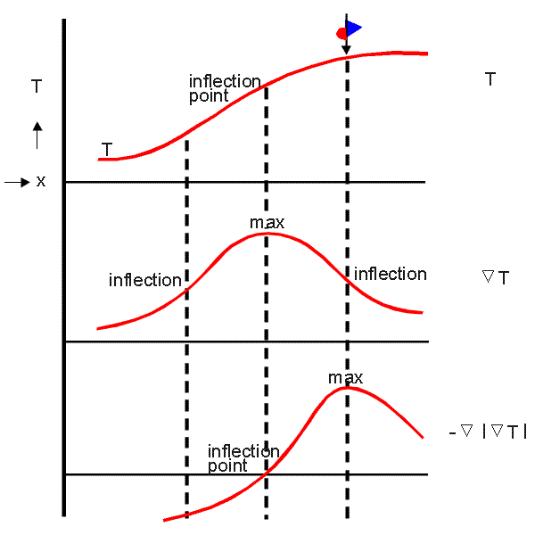
There is a clear relationship between the TFP as frontal analysis parameter and the well-known basic front definition which fixes a Cold Front where temperature begins to fall and a Warm Front where the rise of temperature ends. This definition is identical with the maximum of the TFP as shown below.
The temperature used in the TFP can be taken from any level. The surface temperature field is often used in synoptic practice to locate the surface front. But it can also be taken as a mean value of a layer, for instance from the thickness. This procedure has also some advantages with respect to frontal analysis because the front is a phenomenon not only at the surface but in a deep layer of the troposphere. In the manual and the case studies a so-called equivalent thickness is used which is based on the temperature increase that would occur were all water content condensed. The advantage of such a modified parameter is a sharpening of frontal gradients.
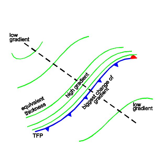
There are relationships between the thickness field and the TFP. As can be seen from the following diagram the maximum of the TFP field which is the location of the front can be found on the warm side of the zones of high thickness gradients because there the change of the thickness gradient is a maximum.
The demonstration case contains some examples of these parameters.
|
11 February 1997/06.00 UTC - Meteosat IR image; green: equivalent thickness 500/850 hPa, SatRep overlay: names of conceptual models
|
11 February 1997/06.00 UTC - Meteosat IR image; green: equivalent thickness 500/850 hPa, blue: thermal front parameter (TFP) 500/850 hPa, SatRep overlay: names of conceptual models
|
|
|
The left image shows equivalent thickness and identifies the following zones of high gradient (crowding zones of isolines) which accompany frontal zones and frontal cloud bands. In the right image TFP maximum zones and frontlines (front indicator) are superimposed. The following areas are worth mentioning:
- A thickness crowding zone over Germany, Poland and the Baltic Sea which is to the rear of the Cold Front cloud band over Central Europe; consequently the TFP maximum line (front indicator) is close to the rear of the cloudiness. This is a situation which can often be observed in Kata Cold Fronts (although in this special case other parameters possibly contradict).
- A thickness crowding zone from the Atlantic across the British Isles to France which coincides with warm front cloud bands. Consequently the TFP maximum and the front indicator are close to the warm edge of the frontal zone which is to the rear of a Warm Front. Such situations are typical of Ana Warm Fronts.
- More indistinct is the situation with the Atlantic Cold Front because there is a broad zone of a relatively equal thickness gradient behind the front. Two areas of maximal changes of the temperature gradient are computed: one within the Cold Front cloud band and a second one in the area of the cloud spiral of the Rapid Cyclogenesis. The analysis of the cloud spiral as an Occlusion is because of the overall situation and is not supported by the thickness configuration.