Temperature Advection
There is a contribution to upward motion where:
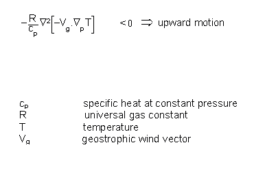
This condition is fulfilled if
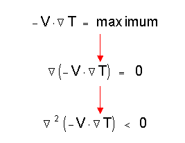
Therefore a contribution to upward motion exists in the maxima of warm advection (WA) which guides an evaluator to look for these maxima in a numerical temperature advection (TA) field.
Typical cloud configurations which are completely or partly connected with this parameter are:
- Warm Fronts
- Conveyor belts
- Cloudiness in thickness ridges
- Waves
- Rapid Cyclogenesis
In contrast, cold advection (CA) contributes to sinking motion and has, therefore, not so much importance in satellite image interpretation. Usually big areas of CA can be found in the areas of cellular cold air cloudiness behind fronts. CA represents the overall downward motion whilst the single cloud cells can be explained in connection with diabatic heat exchange (term 3 in the omega equation (compare Vertical Motion - Omega Equation).
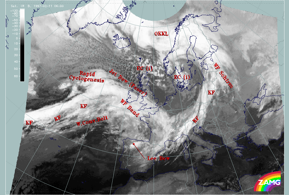
Some practical examples can be found in the test case from 11 February 1997/06.00 UTC.
|
11 February 1997/06.00 UTC - Meteosat IR image; SatRep overlay: names of conceptual models
|
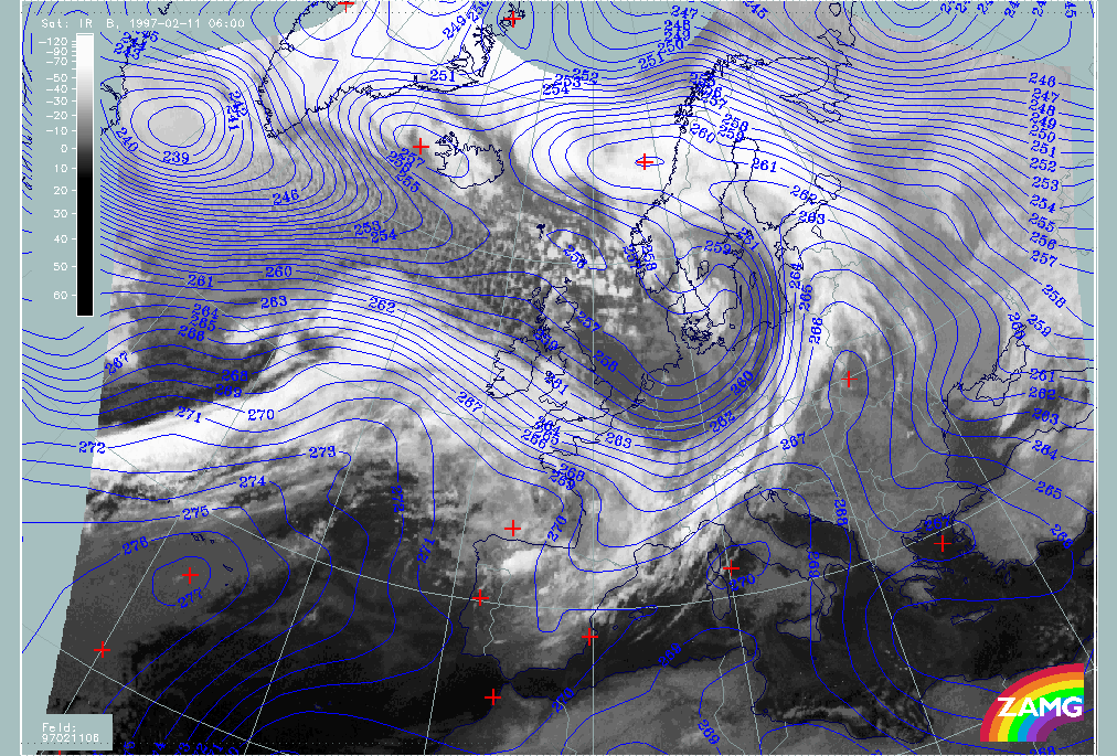
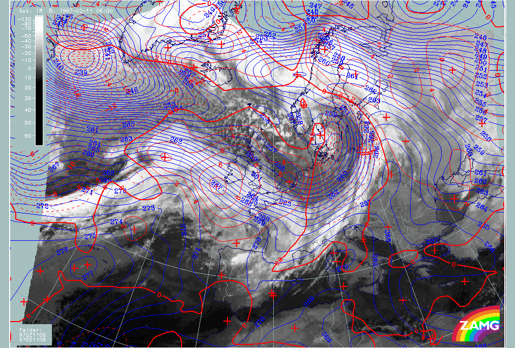
11 February 1997/06.00 UTC - Meteosat IR image; blue: temperature 700 hPa
|
|
|
The following features should to be noted:
- Zones of high temperature gradient (crowded zones of temperature isolines) are connected with frontal cloud bands. They indicate the transition between air masses with different temperatures and can be found in this example with:
- The Cold Fronts ("KF") over the Atlantic and Central Europe:
- The zone of high gradients over the Atlantic is broad possibly indicating two developing frontal zones.
- The zone of high gradients over Central Europe is distinct and partly within, partly behind the cloud band.
- the Warm Front ("WF Band"); the distinct zone of high temperature gradients coincides with the cloud band.
- Ridges indicating high temperatures can usually be found in front of Cold Fronts and in association with occlusion bands where they indicate the lifting of warm air, in agreement with the classical ideas of Occlusion development, and/or the mixing of warm and cold air masses. The following areas are good examples:
- Over the Balkan States and East Europe in front of the Cold Front over Central Europe;
- Over the Atlantic in front of the Atlantic Cold Front and behind the Warm Front;
- From the Baltic States across Finland and Scandinavia into the Norwegian Sea which is associated with the cloud band of an Occlusion (named "OKKL").
- Troughs indicating low temperatures can usually be found behind the frontal zones:
- Over Denmark, Germany and Poland behind the Cold Front over Central Europe.
It will be recalled from the omega equation that it is temperature advection, not temperature, that is the parameter responsible for the development of cloudiness. Therefore both parameters are superimposed on the next image.
Two aspects have to be considered when comparing the two parameters in relation to satellite imagery:
- The relation between temperature at 700 hPa and temperature advection 500/1000 hPa
- The relation of temperature advection to the cloud systems
The following examples can be mentioned:
- Warm advection (WA) can be found in front of the ridge lines of the ridges of high temperature indicating the movement of the warmest air in the ridge line:
- This is very clear for the temperature ridge from the Balkan States across Scandinavia; the main maxima of WA can be found over the Baltic States, Finland and N. Scandinavia;
- Two typical cloud configurations are connected with the WA maxima:
- Warm Front bands or shields (in this case the one named "WF Schirm")
- Occlusion bands (in this case the one named "OKKL")
- The very pronounced WA maximum reaching from Ireland into the Gulf of Biscay indicates the east, north-eastward movement of the warmest air found in the ridge over the Atlantic (approximately 40N/26W - 50N/18W); two cloud configurations are connected with the WA maximum:
- The Warm Front Band ("WF Band") with dense cloudiness
- the Warm Conveyor Belt (labelled "W.Conv.Belt") with more fibrous cloudiness in front of the frontal system; this will be disussed in more detail later under the chapter of relative streams (compare Relative Streams).
- The distinct smaller scale WA maximum in the region of the Rapid Cyclogenesis indicates the advection of the warm air forming the small scale temperature ridge within the frontal crowding zone (approximately 50N/24W - 55N/30W); this WA maximum is connected with secondary cyclogenesis taking place in a Wave development or (as is the case here) within a more rapid development, the Rapid Cyclogenesis
- Cold advection (CA) can be found in front of the cold air troughs starting at the trough line; this indicates the propagation of the coldest air which can be found in the temperature trough. The following examples should be noted:
- Pronounced CA behind the cold front over Central Europe east of the ridge line from Denmark southward to Central France;
- There are only few clouds in the main part of the trough
- The region over the Alpine area is accompanied by frontal cloudiness but with lower cloud tops indicating dissolution of cloudiness from above
- Pronounced CA exists north and north-west of the Rapid Cyclogenesis representing the propagation of the cold air more to the north-west; this is the typical wide area filled with regular cold air cloud cells; they are created where the cold air flows over relatively warm water. Small-scale convective processes are the reason for cloud development but the bigger scale sinking motion restricts the further growing of the cloud cells. Consequently they have warmer cloud tops than the frontal cloud bands.
- A small scale CA area close to the Rapid Cyclogenesis (centred approximately around 48N/27W). There is a typical juxta position of a the initial advection of warm and cold air masses and a strengthening of cyclonic circulation