17 April 1996 - Rapid Cyclogenesis: Diagnosis For 17 April 06.00 UTC
|
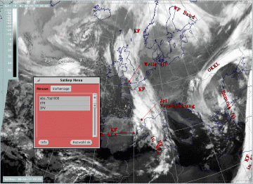
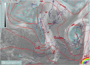
17 April 1996/06.00 UTC - Meteosat IR image; SatRep overlay: names of conceptual models, SatRep menu: key parameters for Cyclogenesis
|
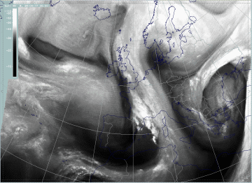
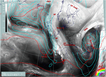
17 April 1996/06.00 UTC - Meteosat WV image; SatRep overlay: names of conceptual models
|
The cloud configuration named "Zyklogenese WV" describes the typical development of a Rapid Cyclogenesis. In a later stage of the SatRep this conceptual model was renamed "Rapid Cyclogenesis" and a new menu with key parameters has been developed. For the conceptual model see Conceptual Models: Rapid Cyclogenesis .
The satellite image shows a typical configuration for such a development:
- There is a frontal cloud band with a Wave - like bulge consisting of cold cloud tops approximately around 51N/25W.
- Cloudiness with warmer tops emerges from underneath this cloud bulge; in this case this can be recognized around 52N/26-27W.
- In the WV image a Dark Stripe representing very dry air can be found on the cyclonic side of the frontal cloud band up to the area of the cloud bulges described above; often a second more northern Dark Stripe exists at the northern boundary of the lower cloud deck which comes forward below the frontal cloud band.
All three features exist in this special case.
| abs.Top1000 + PVA500>=2 + TA>=0: | This is a commonly used combination of three parameters typically indicative of a wave:
|
|---|---|
| Isot + PVA300>=3: | This is a combination of isotachs greater than 30 units (m sec-1) and positive vorticity advection (PVA) at 300 hPa greater than 3 units (*10-9sec-2) |
| Isot300 + Scher300=0: | This parameter combination shows the isotachs greater than 30 units (m sec-1) and the zero line of shear vorticity which marks the jet axis; one can get information about the existence and strength of jet streaks and the course of the jet axis |
| PV: | Represents isentropic potential vorticity (*10-6m2sec-1K kg-1) on several levels |
| VQS: | Gives the location of available vertical cross sections (VQS) |
|
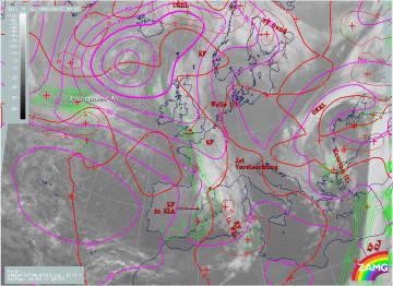
17 April 1996/06.00 UTC - Meteosat IR image; cyan: height contours 1000 hPa, red: temperature advection - WA 1000 hPa, green: positive
vorticity advection (PVA) 500 hPa; SatRep overlay: names of conceptual models
|
|
This parameter combination shows a rather typical behaviour of the three key parameters from the numerical model except for the fact that the WA maximum seems to be somewhat displaced to the south-west.
|
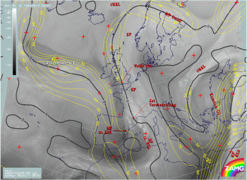
17 April 1996/06.00 UTC - Meteosat WV image; isotachs 300 hPa, black: shear vorticity 300 hPa; SatRep overlay: names of conceptual
models
|
|
There is a jet streak in the area of the Rapid Cyclogenesis under consideration but it fits neither the southern nor the northern Dark Stripe. This is an indication that the numerical model is not correct there and is not able to resolve the two dry air streams.
For a further clarification additional key parameters have to be inspected e.g. the PV and relative streams (compare Conceptual Models: Rapid Cyclogenesis - Meteorological physical background ).
|
17 April 1996/06.00 UTC - Meteosat IR image; cyan: potential vorticity (PV) 305K, red: isobars; SatRep overlay: names of conceptual
models
|
17 April 1996/06.00 UTC - Meteosat IR image; cyan: potential vorticity (PV) 320K, red: isobars; SatRep overlay: names of conceptual
models
|
Neither the lower isentropic level of 305K nor the higher isentropic level of 320K show an acceptable correspondence between the dry stratospheric air and the Dark Stripes. In the lower level the high PV values are too far in the north to have any connection with the cloud configuration of the Rapid Cyclogensis. This may be interpreted as indicating that dry stratospheric air has not yet protruded downward to 500 - 400 hPa. In the higher level a small zone with PV values higher than 3 units can be recognized from approximately 48N/35W to 51N/10W. This zone is indeed parallel to the Dark Stripes in the WV imagery but a southward displacement may be reasonable. This could lead to the conclusion that dry stratospheric air has reached a height of 300 hPa in this isentropic layer. But it has generally to be concluded that the physical state in these upper levels described by the numerical model does not satisfactorily coincide with the features in the satellite images. In particular the fine structure of the two dry streams cannot be resolved, and dry air characterized by high PV values can be found only in higher levels than those usually found in this stage of development.
|
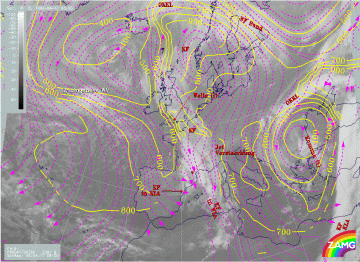
17 April 1996/06.00 UTC - Meteosat IR image; magenta: relative streams 300 K - system velocity 209° 8 m/s, yellow: isobars; SatRep
overlay: names of conceptual models
|
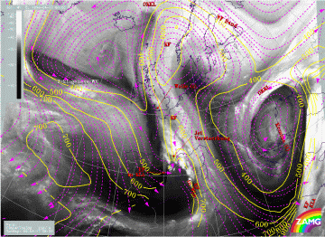
17 April 1996/06.00 UTC - Meteosat IR image; magenta: relative streams 308 K - system velocity 208° 9 m/s, yellow: isobars; SatRep
overlay: names of conceptual models
|
Relative streams in the two isentropic layers of 300K and 308K reveal some of the typical features for a Rapid Cyclogenesis (compare Conceptual Models: Rapid Cyclogenesis - Meteorological physical background ). There is for instance at the 300K level a relative stream from south-south-east heavily rising from 800 up to 500 hPa and splitting there into an eastern and a western branch. At the higher level this splitting does not occur but a stream from north-westerly directions is superimposed on the cloud bulges at 400 hPa. Nevertheless the errors of the model discussed above have to be taken into account so that these features can only be regarded as a rough indication of the ongoing processes.
One can summarize that this is a situation where the satellite images indicate the initial stages of a Rapid Cyclogenesis which is also represented by most of the key parameters of the numerical model, but the latter is neither correct in position nor in the ability to resolve fine structures.
