17 April 1996 - Cyclogenesis In The Western Mediterranean: Forecast For "Special Investigation" 17 April 12.00 UTC To 18.00 UTC
In the diagnosis of this special investigation two distinct conceptual models have been identified:
- A Jet Intensification which is accompanied by intensified cloudiness over France.
- Frontal cloud bands which are in a state of re-shaping under the influence of cyclogenesis in the western Mediterranean.
|
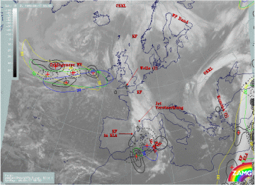
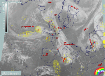
17 April 1996/06.00 UTC - Meteosat IR image; yellow: positive vorticity advection (PVA) 500 hPa 06.00 UTC, green: positive vorticity
advection (PVA) 500 hPa 12.00 UTC, blue: positive vorticity advection (PVA) 500 hPa 18.00 UTC; SatRep overlay: names of conceptual
models
|
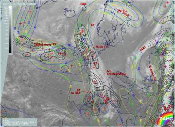
17 April 1996/06.00 UTC - Meteosat IR image; yellow: positive vorticity advection (PVA) 300 hPa 06.00 UTC, green: positive vorticity
advection (PVA) 300 hPa 12.00 UTC, blue: positive vorticity advection (PVA) 300 hPa 18.00 UTC; SatRep overlay: names of conceptual
models
|
The position of the PVA maxima at the 300 and 400 hPa levels for 06.00 UTC (solid), 12.00 UTC (dashed) and 18.00 UTC (solid again) shows a fast south-eastward propagation from France to a position close to Sicily for the 300 hPa level, and from the east Pyrenees to South Sardinia for the 500 hPa level. The PVA maxima remain strong during the whole forecast period. But it has to be remembered that there was a remarkable discrepancy between the forecast and analysis fields; especially the 500 hPa surface showed a separate PVA maximum in the area of the western short frontal cloud band (compare Cyclogenesis in the Western Mediterranean: Diagnosis for 17 April 06.00 UTC ). Therefore, the following images show a comparison between the forecast and the computed positions of the PVA.
|
17 April 1996/18.00 UTC - Meteosat IR image; yellow: positive vorticity advection (PVA) 500 hPa 06.00 UTC, green: positive vorticity
advection (PVA) 500 hPa 12.00 UTC, blue: positive vorticity advection (PVA) 500 hPa 18.00 UTC; SatRep overlay: names of conceptual
models
|
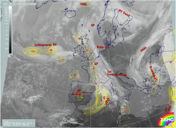
17 April 1996/12.00 UTC - Meteosat IR image; ECMWF analysis data; yellow: positive vorticity advection (PVA) 500 hPa; SatRep overlay:
names of conceptual models
|
|
17 April 1996/18.00 UTC - Meteosat IR image; yellow: positive vorticity advection (PVA) 500 hPa 06.00 UTC, green: positive vorticity
advection (PVA) 500 hPa 12.00 UTC, blue: positive vorticity advection (PVA) 500 hPa 18.00 UTC; SatRep overlay: names of conceptual
models
|
17 April 1996/18.00 UTC - Meteosat IR image; ECMWF analysis data; yellow: positive vorticity advection (PVA) 500 hPa; SatRep overlay:
names of conceptual models
|
The images show the development of a mesoscale cloud spiral in the area of the western cloud band and a relatively good coincidence with the position of the PVA maxima in both the forecast as well as the analysis fields. Only for 18.00 UTC does the PVA maximum shown by the analysis fields clearly match the cloud spiral better than that in the prognostic fields.
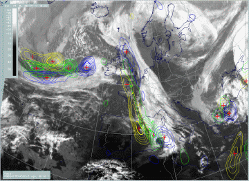
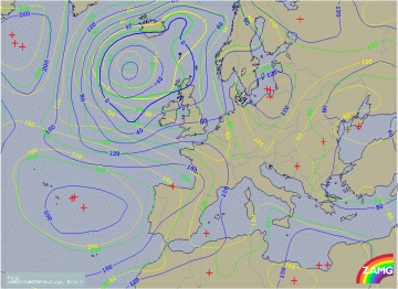
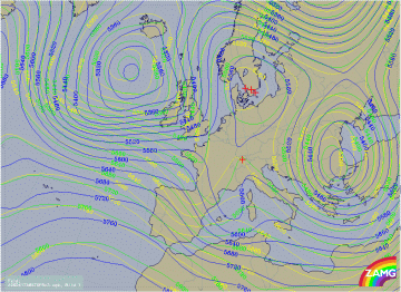
This fast development of the frontal cloud band to a cloud spiral can also be followed and predicted with help of the contour fields and shows up as a phenomenon at the 500 hPa level. While the surface low, which was connected with the eastern cloud band at 06.00 UTC, is filled until 18.00 UTC, the short Wave upper level trough develops till 18.00 UTC and becomes more and more pronounced. The two parameters of PVA and upper level height are typical indicators of the formation of such a cloud spiral.
|
17 April 1996/06.00 UTC; yellow: height contours 1000 hPa 06.00 UTC, green: height contours 1000 hPa 12.00 UTC, blue: height contours
1000 hPa 18.00 UTC
|
17 April 1996/06.00 UTC; yellow: height contours 500 hPa 06.00 UTC, green: height contours 500 hPa 12.00 UTC, blue: height contours 500
hPa 18.00 UTC
|
After having noticed the forecast fields and the developed cloud configurations, a different diagnosis of the cloud feature along the Spanish east coast would also be possible for the 06.00 UTC image: it could be a Comma configuration which appears close behind the frontal cloud band and leads to the transition of a Cold Front into a Warm Front by creating a height and thickness ridge in front of the Comma.
