Chapter II: Pre-conditions to Fire
Table of Contents
- Chapter II: Pre-conditions to Fire
- Introduction
- Climatologic background
- Weather Conditions
- Vegetation conditions
Introduction
Forest fires are a natural phenomenon and important to forests' natural life cycles. In southern Europe these events have became seasonal ecological disasters. As mentioned before, the pre-conditions to forest fires include the fuel or vegetation state, the weather conditions and the topography. The effects of topography on fire spread are complex but, in general, steep slopes cause faster fire spread rates. Nevertheless, rough topographies always cause difficulties in firefighting and forest fires tend to have larger impacts in mountain regions. The Caramulo fires occurred in a mountainous region (Figure 2) and therefore in adverse terrain conditions. The next sections will address the other factors which contributed to this particular series of forest fires.
Climatologic background
Knowledge of the climatological background prior to the Caramulo fires is central to understanding the vegetation conditions. In fact, besides precipitation and temperature conditions preceding the fires, the state of vegetation also depends on the meteorological conditions during the vegetation growth cycle, several months prior to the fire event. When compared to the 1971-2000 climatological mean for the Caramulo area, the accumulated precipitation from October 2012 to April 2013 was above average (Figure 3a). At the beginning of the "fire season" (June 2013) the Caramulo region was thus moderately moist, according to the Palmer Drought Severity Index (PDSI) (Figure 3d). In short, meteorological conditions during the growth cycle were favorable to the production of vegetation, i.e. fire fuel.
a)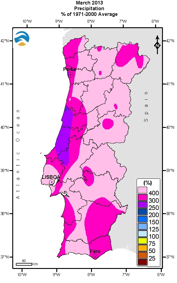 |
b)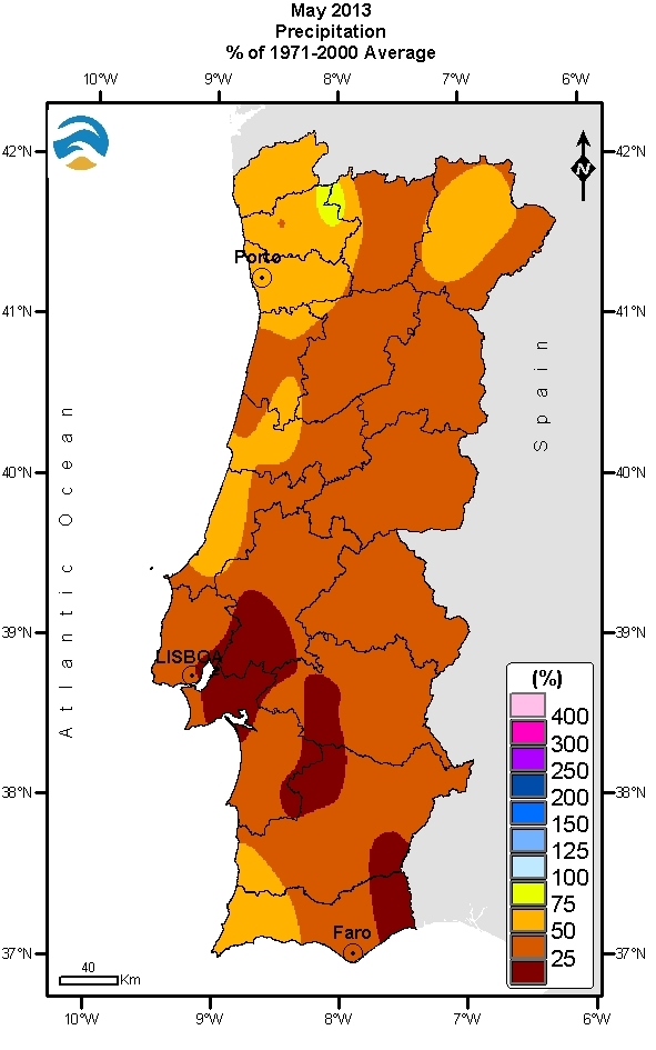 |
c)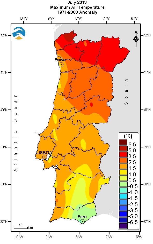 |
d) |
| Figure 3: Relative to 1971-2000; (a) percentages of precipitation totals for March 2013, (b) percentages of precipitation totals for May 2013, (c) mean air temperature anomalies for July 2013 and (d) Spatial distribution of Palmer Drought Severity Index (PDSI) on 30 June. | |
Conversely, from May 2013 onwards the precipitation fell well below climatological values (Figure 3b) and from July onwards the temperature was clearly above the mean (Figure 3c). These conditions reduced the amount of moisture content on biomass and increased the amount of flammable vegetation. The month of August saw several days with minimum temperatures above 20 °C and maximum temperatures above 35 °C. During July and August several consecutive days with no precipitation were observed in the northwest of Portugal. These months were classified as dry to very dry in the Caramulo region.
Weather Conditions
From 29 July to 18 August 2013 there was a High pressure system located over the Azores region and a thermal trough over the Iberian Peninsula. From 19 August on, the High pressure system intensified and extended towards the British Isles while the weak thermal Low pressure area was established over central Iberian Peninsula (Figure 4a). Therefore, a hot dry air mass from Spain and North Africa which lead to high air temperature and low humidity conditions in Portugal (Figure 4b). The wind in the northern and central part was from the east, being moderate to strong at night in mountain regions as the Caramulo. Two heat waves hit northern and central regions of Portugal during August - one at the beginning and another at the end of the month.
a)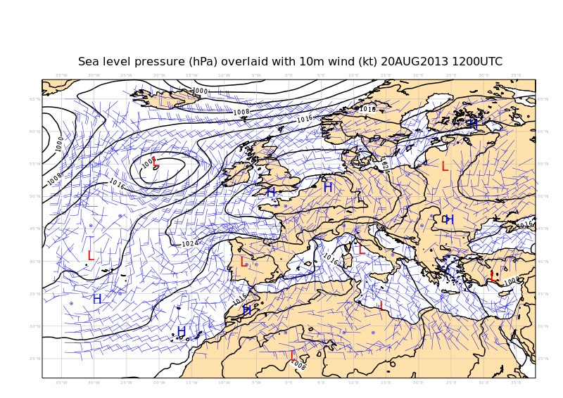 |
b)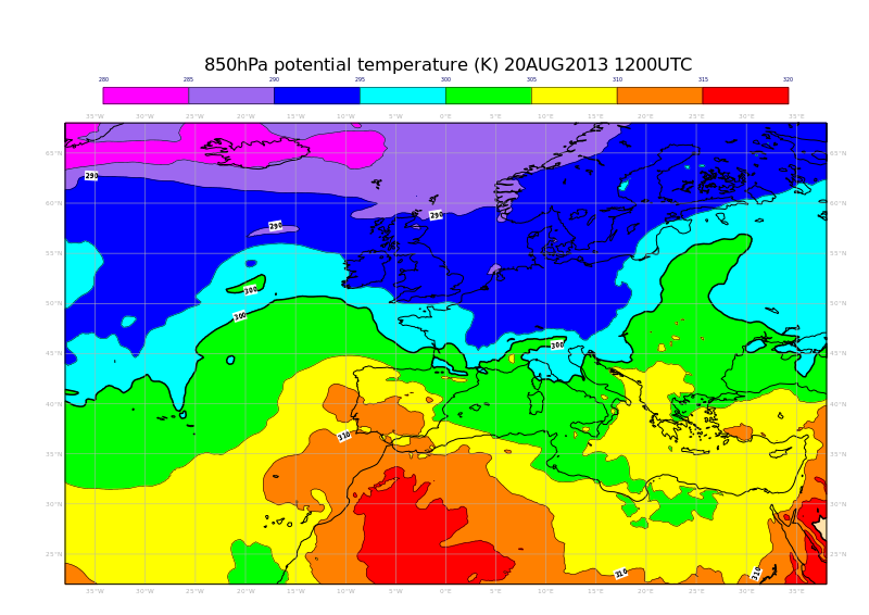 |
| Figure 4: ECMWF analysis a) mean sea level pressure and 10 m winds (in knots) and b) potential temperature at 850hPa. |
Vegetation conditions
Remote sensing provides the best means to monitor changes in vegetation over time across large areas. The Fraction of Vegetation Cover (FVC) from LSASAF is a product derived for the MSG SEVIRI satellite channels and gives the fraction of vegetation per unit area on a horizontal surface (http://www.eumetrain.org/resources/monitoring_vegetation.html). It is based on the different spectral signatures of vegetation and background in the MSG channels on the central wavelengths of 0.6, 0.8 and 1.6 µm. The hydrological conditions during 2013 lead to favorable conditions for vegetation to grow (Figure 5a). In fact, when considering the FVC obtained on 30 June 2013 and the mean June conditions, positive anomalies appear in northwestern Iberian Peninsula, including the Caramulo area (Figure 5c).
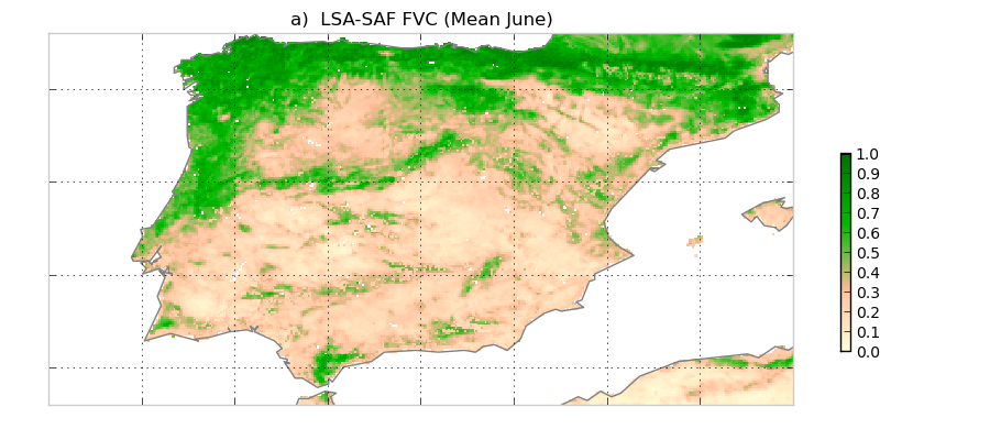
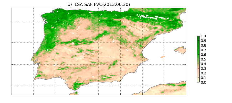
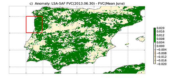
Figure 5: LSASAF FVC values for June on average (a), for 30 June 2013 (b), and for the difference between the mean values and those of 30 June 2013 (c). Greenish values signify thicker vegetation cover than the monthly mean while yellowish tones mark below-average values.