Chapter VII: Satellite data and products
Table of Contents
In this section the pre-convective environment will be studied first on the basis of satellite imagery, then the convection initiation, and lastly the mature stage.
Pre-convective environment
From satellite data one can retrieve information on instability and moisture content in cloud free pixels. These parameters are useful for spotting future convective potential.
EUMETSAT provides two product groups on moisture and instability info in cloud-free pixels:
- the Global Instability Indices (GII) derived by the Central Application Facility (CAF) and
- the SEVIRI Physical Retrieval products (SPhR) derived by NWCSAF.
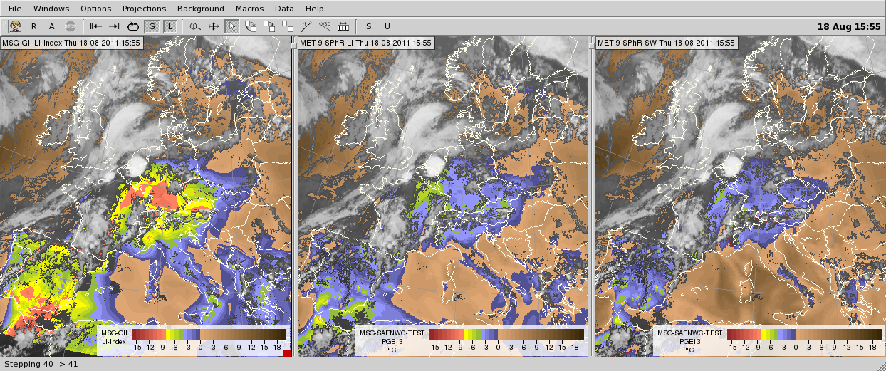
GII consists of (among others) total precipitable water, K and lifted indices. SPhR includes (among others) total precipitable water, K, lifted and Showalter indices. Note that the definitions of GII lifted index and of SPhR lifted index are not the same. The GII lifted index is calculated by 'lifting' a virtual air parcel from the surface to 500 hPa and comparing its temperature to that of the environment. The SPhR lifted index is calculated likewise, except that the parcel's initial temperature is an average from a layer just above the surface. The thickness of this layer can be 100 hPa or 1000 m.
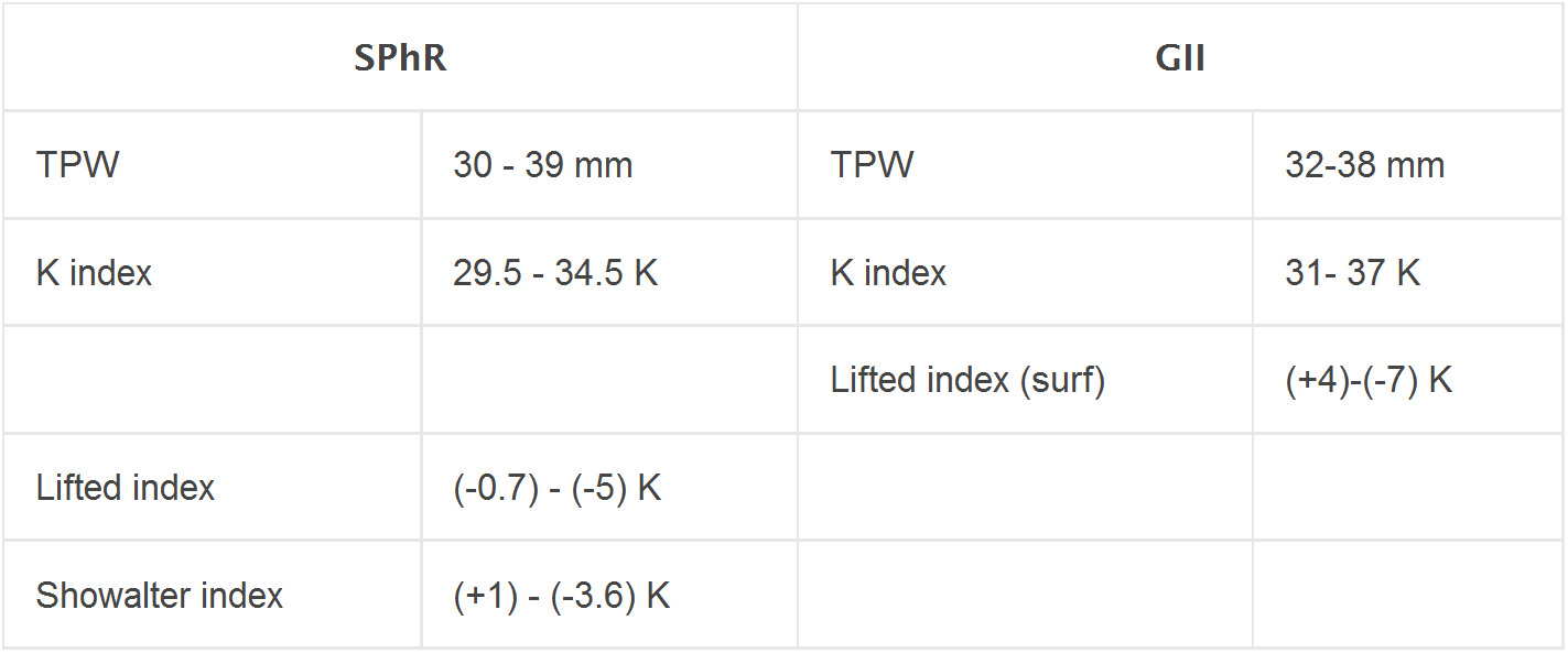
Table 1 shows typical values of satellite-retrieved total precipitable water and instability indices for the studied area or close to it between 05 and 17 UTC. In the afternoon these values indicated a buoyant atmosphere, with significant moisture.
Table 1. Typical values of the moisture and instability parameters between 05 and 17 UTC.
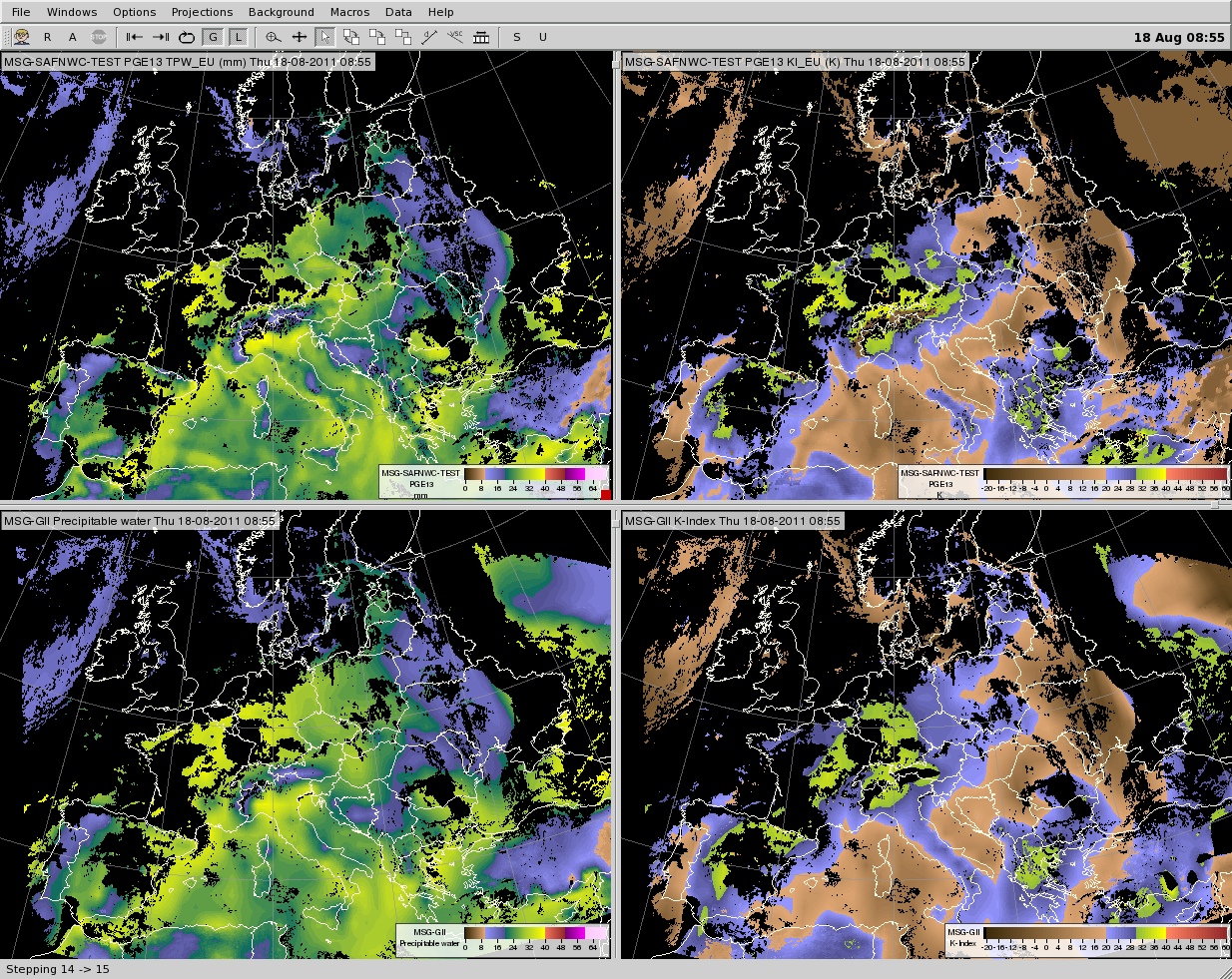
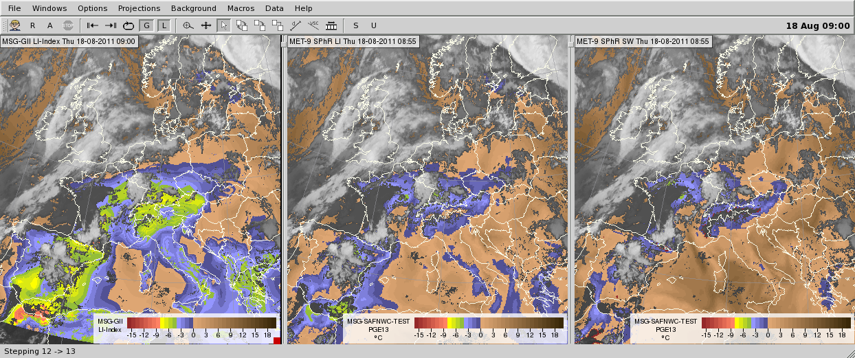
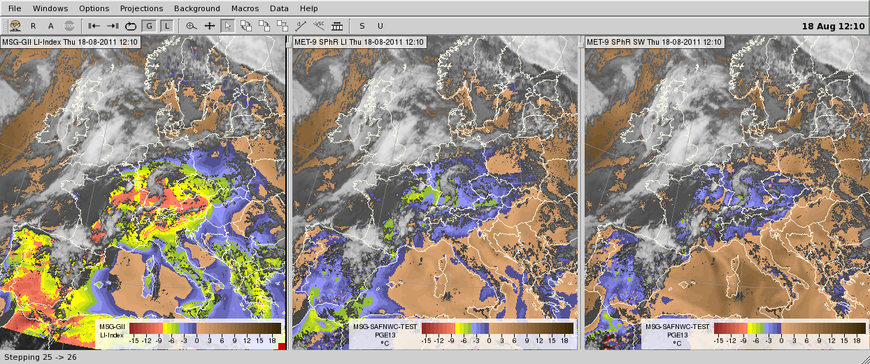
Fig. 7.1 presents total precipitable water and K index at 08:55 UTC retrieved by both methods, while Fig. 7.2 presents GII and SPhR lifted indices and Showalter index. GII lifted index has a higher diurnal cycle than the SPhR lifted and Showalter indices.
Fig. 7.1. GII and SPhR total precipitable water (left panels) and K index (right panels) for 08:55 UTC). The upper panels show the SPhR products, the lower panels show the GII products (colors in clear air pixels). Cloudy pixels are black.
Fig. 7.2. GII and SPhR instability indices for 08:55, 12:10, 15:55 UTC in the upper, middle and bottom rows, respectively. GII lifted index (left column), SPhR lifted index (middle column), SPhR Showalter index (right column). The colors represent the instability values in cloud-free pixels.
Convection initiation
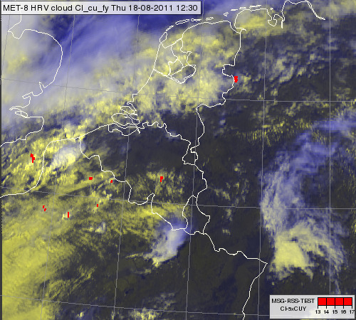
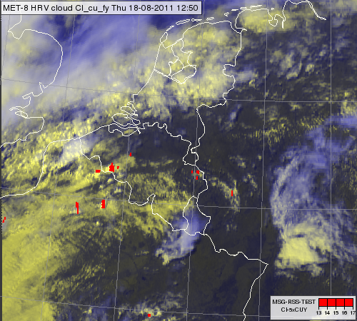
The aim of the Convection Initiation (CI) product is to find the towering, rapidly developing cumulus clouds just crossing the zero °C isotherm. Based on the SATCAST box-average method 5-minute Convection Initiation (CI) product was produced at the Hungarian Meteorological Service for the studied windstorm. It was found that the first cells which later contributed to the windstorm system initiated at about 12:20-13:00 UTC over France and Belgium; see Fig. 7.3 and the animation.
Fig. 7.3. Meteosat 8 HRV cloud RGB image for 12:30 UTC (left) and 12:50 UTC (right) overlaid by the Convection Initiation product (red pixels) showing the rapidly developing cumulus clouds.
Click here to see the animation created from 5-min HRV cloud RGB and CI data between 11:35 and 16:05 UTC.
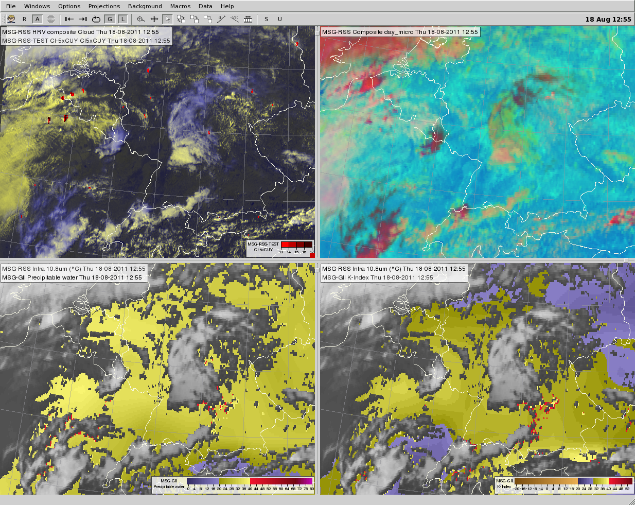
It is reasonable to use the CI product together with clear air products (moisture and instability). For convection instability, moisture and lift are needed. CI shows whether lift is present, while clear air products show whether instability and moisture are present.
Fig. 7.4. Meteosat 8 satellite images and products for 12:55 UTC. HRV cloud RGB image overlaid by the Convection Initiation product (upper left), day microphysics RGB (upper right), IR10.8 image overlaid by the GII total precipitation product (lower left) and IR10.8 image overlaid by the GII K index product (lower right).
The day microphysics RGB shows the process of cloud top glaciations (the color turns to red), so this RGB is very informative in the convection initiation phase.
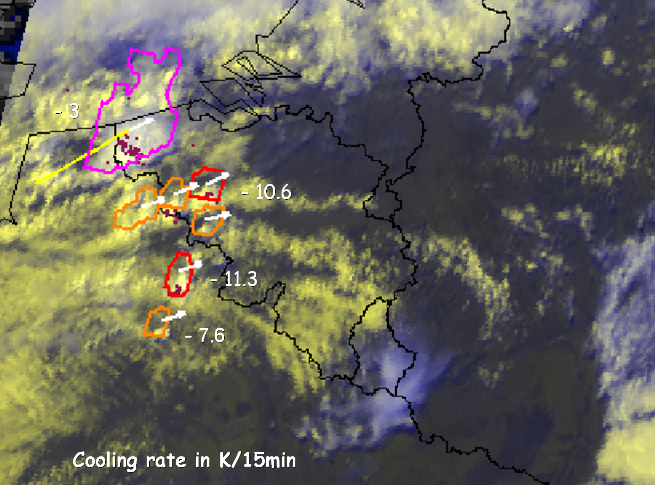
The Rapid Developing Thunderstorm (RDT) product of NWCSAF showed that these cells cooled fast. RDT detects the convective cloud systems and also characterizes them by calculating several quantities, like cooling rate. Note that RDT was run at OMSZ with lightning data (optional input) to make the convective cloud detection more effective in the developing phase.
Fig. 7.5. Meteosat 9 HRV cloud RGB image for 13:10 UTC overlaid by 10-min lightning data (dots) and by NWCSAF RDT product (contours). Developing and mature convective cells are indicated by red and pink contours, respectively. Cells detected as convective for the first time have an orange contour. The cooling rates of the detected convective cells are indicated in the image.
You can read about the NWCSAF RDT product here.
Mature thunderstorm system
Some features on the mature convective thunderstorm (system) cloud top, if present, could indicate the severe nature of the storm. Such cloud top features are: intense, long-lasting overshooting tops (OT); frequent, intense OTs, intense gravity waves, long-lasting cold ring or cold-U/V shapes in the IR10.8 image, presence of an ice plume etc. These features, if present, are mainly seen in HRV and/or in IR10.8 channels. HRV shows the cloud top morphology due to shadows and IR10.8 shows the brightness temperature distribution.
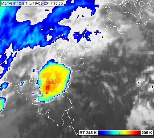
In Fig. 7.6 we show an IR10.8 image on the studied windstorm, enhanced with the standard color scale. Both the left and right panels show the same image, but on the right panel the color scale is shifted by 5 K degree towards the warmer temperatures to obtain a better contrast. The tropopause was relatively low, which is why the cloud top temperature was not so cold. (The tropopause temperature was about -55 °C at 12 UTC according to the de Bilt radiosonde measurement, see Fig. 5.4. The anvil temperature was around -56 °C, while the temperature of the overshooting tops was about (-61)-(-66) °C.)
Fig. 7.6. Meteosat 8 IR10.8 images from 15:30 UTC enhanced with the standard color scale (left) and with the same color scale but shifted towards the warmer temperatures by 5 K (right)
Click here to see the animation created from 5-minute IR10.8 images between 11:35 – 18:35 UTC.
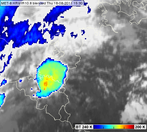
A new visualization method was developed to combine the HRV and the IR10.8 channel data to see the cloud top features better. This is the so-called HRV/IR10.8 blended image (or 'sandwich' image). You can read here about the 'sandwich' product.
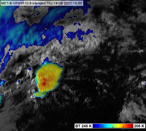
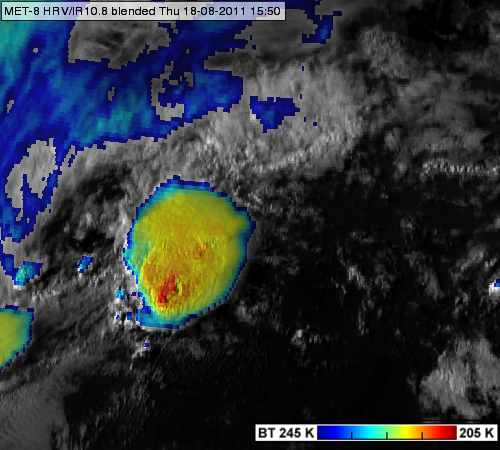
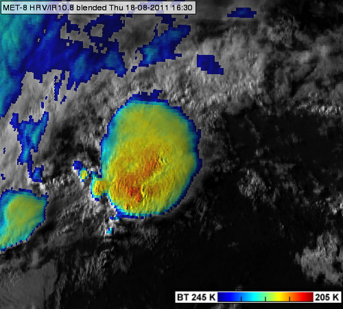
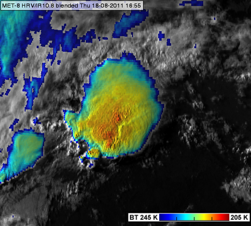
In Fig. 7.7 HRV/IR10.8 blended images are presented in four slots. In the animation we can follow the evolution of cloud top features easily. Intense OTs are seen during the whole period. Some were long-lasting. Intense gravity waves are present in many images, for example at 16:10 UTC. The first warm spot appeared at 14:30 UTC. Cold ring features can be recognized from 15:15 UTC. An ice plume appeared at 15:50 UTC and it could be seen until the sun went down.
Fig. 7.7. Meteosat 8 HRV/IR10.8 blended images for 15:20 (upper left), 15:50 (upper right), 16:30 (below left) and 16:55 (below right) UTC.
Click here to see the animation created from 5-minute HRV/IR10.8 blended images between 11:35 – 18:35 UTC.
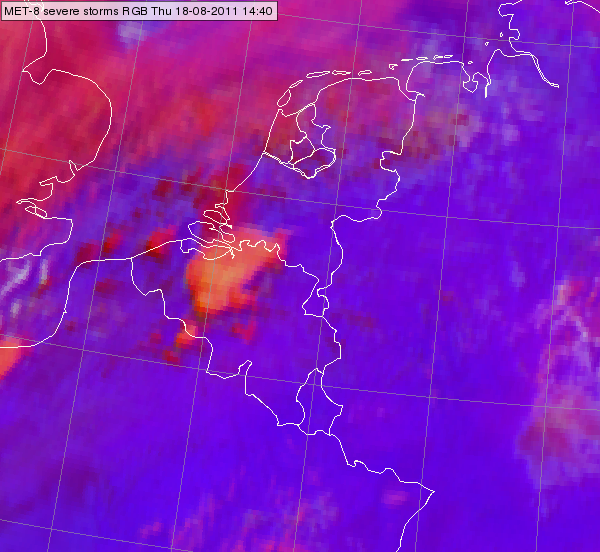
Cloud top microphysics could give information on updraft intensity. Strong updrafts usually produce small ice crystals at the cloud top. The studied thunderstorm system has a yellowish color in the severe storms RGB, in spite of the fact that its cloud top was not so cold. In the present case the yellowish color indicates the presence of small ice crystals in the cloud top, which in turn implies the presence of a strong updraft (Fig. 7.8.).
Fig. 7.8. Meteosat 8 severe storms RGB for 14:40 UTC
