Chapter IV: Synoptic scale processes on the European satellite images
Table of Contents
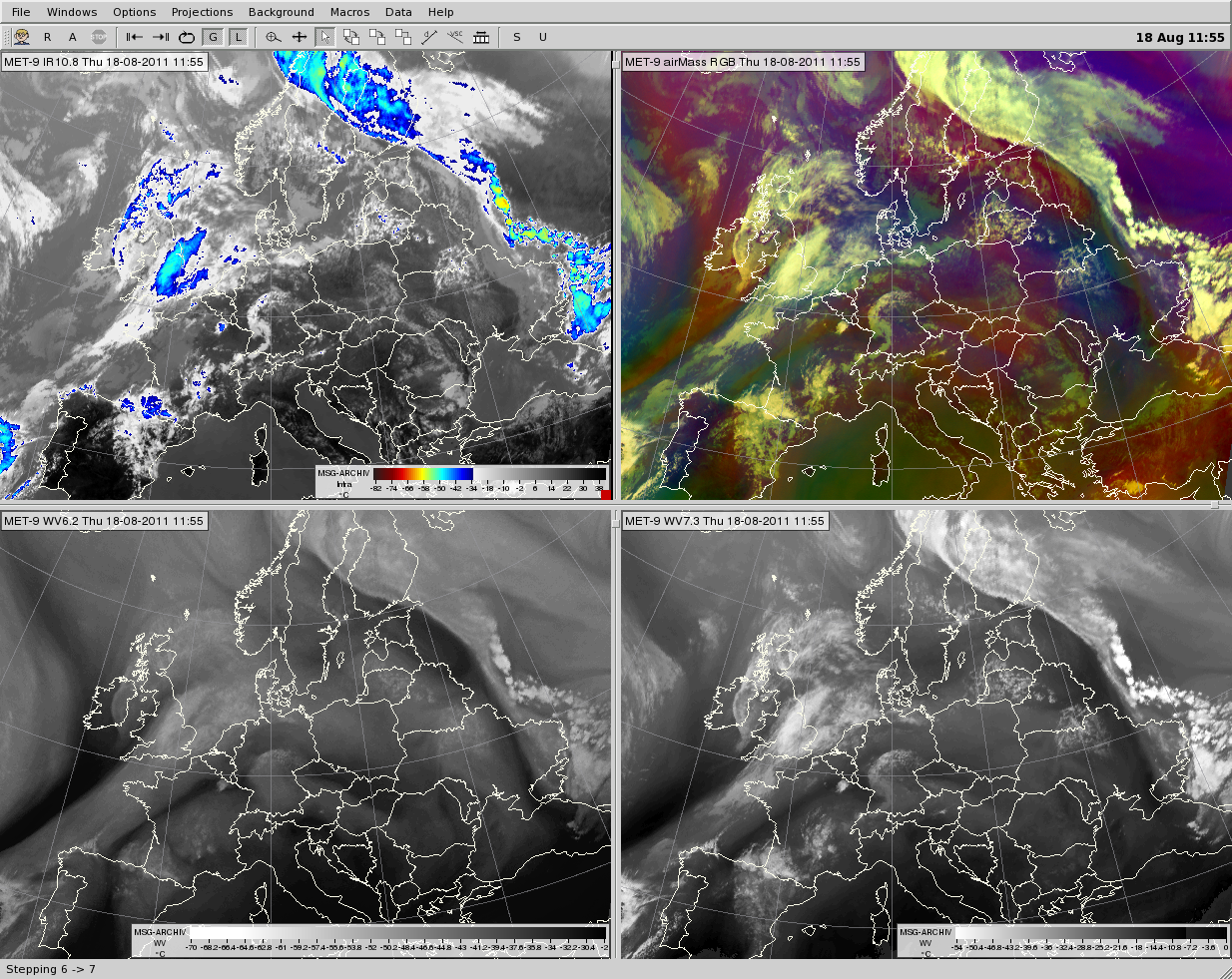
European-scale cloud and WV patterns can be seen in Fig. 4.1. In the WV6.2 and WV7.3 images (below left and right panels) one can see the SW-NE-direction dark stripe across France and Belgium, which played an important role in the storm's development and in the downdraft intensity (see the 'Description of the synoptic situation' section). In the animation one can follow the development of the windstorm over France and Belgium, and its propagation over the Netherlands and Germany. The upper left panel shows the IR10.8 image enhanced with the standard color scale. The top of the windstorm was not extremely cold. The anvil temperature was about -56 °C, while the temperature of the overshooting tops was about (-61)-(-66) °C. IR10.8 images will be analyzed in detail in the 'Mature stage' section.
Fig. 4.1. Meteosat-9 images for 11:55 UTC. IR10.8 (upper left), airmass RGB (upper right), WV6.2 (below left) and WV7.3 (below right)
Click here to see the animation created from 15-minute images between 10:10-18:55 UTC.
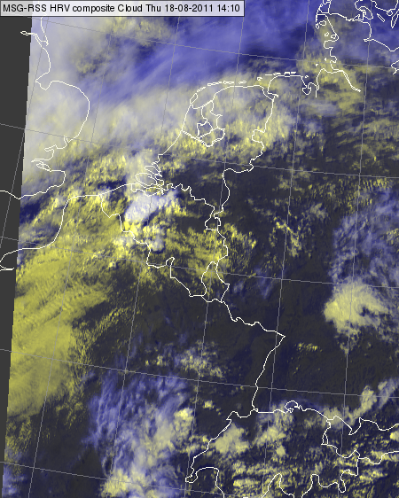
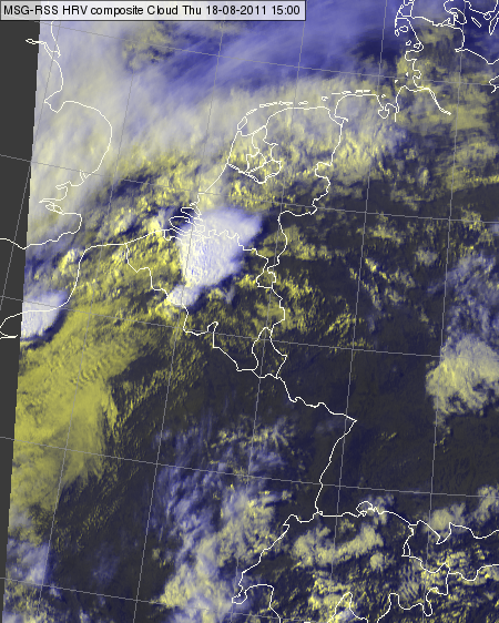
Sometimes in the satellite images one can find traces of wind. For example in Fig. 4.2 one can see waves in the low/mid level clouds over France. One can see it even more clearly in the HRV cloud RGB animation. These waves show the presence of long-lasting low level wind from the SW towards the new storm system. This supports Fig. 2.3 in the synoptic situation description section, where the ECMWF forecasted low level wind and equivalent potential temperature fields show that the southwesterly wind brought warm, moist air towards the studied area in the lower levels.
Fig. 4.2. Meteosat-8 HRV cloud RGB images, 14:10 UTC (left) and 15:00 UTC (right)
Click here to see the animation created from 5-min HRV cloud RGB images between 11:35-18:10 UTC.
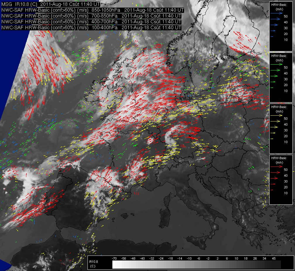
Wind field can be retrieved from satellite imagery. Fig. 4.3 and the corresponding animation show the NWCSAF High Resolution Wind (HRW) product. Vectors with different colors indicate retrieved winds in different pressure layers. This product supports the ECMWF analysis and forecasts shown in the 'Synoptic situation description' chapter, which indicate that the main wind direction in the studied area was southwesterly.
Fig. 4.3. Meteosat 9 IR10.8 image for 11:40 UTC overlaid by NWCSAF High Resolution Wind (HRW) product. The blue, green, yellow and red arrows show the wind vectors in the 1050 - 850 hPa, 850 - 700 hPa, 700 - 400 hPa and 400 - 100 hPa layers, respectively.
Click here to see the 15-minute HRW animation between 00:15-23:15 UTC. For more about the NWCSAF HRW product see here.
Comparing the main environment wind fields in the HRW animation and the windstorm propagation in the HRV cloud RGB animation (by visually tracking the largest overshooting tops) one can see that the windstorm was a 'right mover'. Its propagation deflects to the right from the environment wind field.
As HRW is retrieved by tracking the movement of the clouds, we expect arrows deflecting to the right over a right mover storm. To confirm the right movement of the storm a HRW re-analysis was performed by the developer of the HRW product, with a special configuration without using NWP wind field as the first guess. The results can be seen in Fig. 4.4 and in the corresponding HRW animation. The re-analyzed HRW fields confirm that the retrieved winds deflect to the right (to the east) with respect to the mean southwesterly flow in the eastern and southern flank and also inside the storm (e.g. Fig. 4.4).
Fig. 4.4. Meteosat 9 IR10.8 image for 15:25 UTC overlaid by the re-analyzed NWCSAF High Resolution Wind product. Wind barbs with different colors indicate retrieved winds in different pressure layers (indicated in the image legend). The coast line is depicted by pink line. Courtesy to Javier García-Pereda (AEMET).
Click here to see the 15-minute re-analyzed HRW animation between 12:00-23:45 UTC.


