Motivation
Many winter weather phenomena represent a potential danger, like cold outbreak, heavy snow, ice and freezing rain. Extreme weather conditions can cause infrastructural damage and transport problems, while in case of very heavy precipitation remote areas can be completely cut off. Winter hazards also include the bitterly cold air and winds that threaten with frostbite and hypothermia anyone caught without a shelter. Winter time can be dangerous therefore there is a need for duly forecast and warnings.
Introduction
Several kinds of precipitation can occur during winter time: rain, freezing rain, sleet, ice pellets and snow. Generally, the precipitation type is dependent of the temperature profile of the atmosphere.
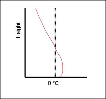
All precipitation starts out as ice or snow crystals at a cloud level. When this frozen precipitation falls into a layer of sufficiently warm air (with temperatures above freezing) it melts into rain. If this warm air extends all the way to the surface of the earth, rain will fall on the ground. If the layer is entirely below freezing, it will snow. There are also situations when the temperature layer above the ground is around 0°C, in that case mixed precipitation may occur – rain and snow together (sleet).
The hardest prognostic situation is when there is a intruding warm layer in between the cloud and the surface. If the warm layer is shallow, the snow will melt on its way down to the surface, but as the newly melted drops fall into a thick layer of cold air closer to the surface, they re-freeze into ice pellets. These little balls of ice bounce off any surfaces making a distinct "pinging" sound.
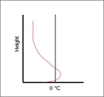
With a thicker warm layer and shallow cold layer above the surface the newly melted drops will remain unfrozen and will not have enough time to freeze into ice pallets before reaching the ground. This droplets then become supercooled and will freeze on impact with surface forming a layer of ice on roads, trees, buildings, electrical lines and cars. This pehenomena is known as freezing rain. It most often occurs when relatively warm, moist air moves over a cold polar or arctic air mass near the Earth's surface.
 |
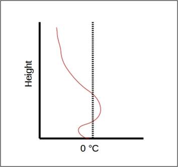 |
| Atmospheric temperature profile for freezing rain | Atmospheric temperature profile for ice pellets |
 |
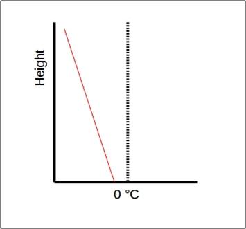 |
| Atmospheric temperature profile for rain | Atmospheric temperature profile for snow |
With this simulator you will practice forecasting winter weather conditions in Croatia by using satellite data as well as synoptic charts and forecasting materials. Your task will be to make a general forecast for three different areas in the upcoming days and if necessary issue warnings. Simulation will last for about 30 min.
To refresh your RGB knowledge, click here.
* TECHNICAL NOTE: For the best interactive experience throughout this module please use the most recent versions of Firefox or Internet Explorer browser!