Meteorological Physical Background
Medicanes are rare (~ 1-2 per year) intense and destructive warm-core cyclones occasionally generated in Mediterranean Basin.
Because of their resemblance in appearance (Figure 1) and mechanisms of maintenance with hurricanes, those mesoscale storms have been referred to as 'medicanes' (from MEDIterranean hurriCANES). Similar to tropical cyclones, they only form over the sea and decay after landfall.
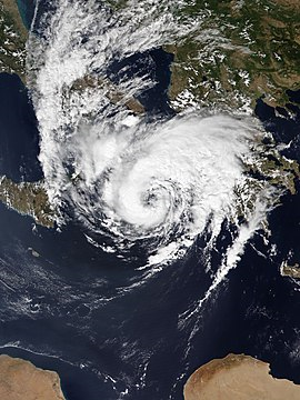
Figure 1: Medicane Ianos - The Copernicus Sentinel-3 - 17 September 2020 at 8:48 UTC (left) and Hurricane Ophelia (near the Azores) - MODIS satellite image (true colour) 12 October 2017 at 15:30 UTC (right)
The difference is that medicanes are weaker and smaller in size, with diameters under 300 km, while the diameter of a hurricane is larger than 1000 km. Hurricanes move in general from east to west due to easterly winds, while medicanes generally (but not always) move from west to east due to the mid-latitude westerlies.
Medicanes mostly occur in the western Mediterranean and in the region extending from the Ionian Sea to the North African coast. There is strong variability from year to year without any significant trends.
Between 1947 and 2020, 91 tropical-like cyclones (TLC) were recorded over the Mediterranean. An analysis of these records shows that these events mostly take place late in the year, with the highest rates found in September (21 cases), followed by October, December and November (Figure 2). The reason for this is the combination of cold upper air intrusions and sea water that has had time to warm up. Medicanes most commonly impact the Balearic and Aeolian Islands, Sardinia, Sicily, and southern Italy, although large numbers of casualties have also been recorded on the northern coast of Tunisia. In the past few years, storms such as Zorbas (2018) and Ianos (2020) resulted in casualties and significant damage in Greece.
The numbers do not necessarily mean that all occurrences of medicanes have been recorded, especially ones before comprehensive satellite observations. With the development and constant improvement of satellites, the number of clearly identified medicanes has increased from the 1980s onward (Figure 3).
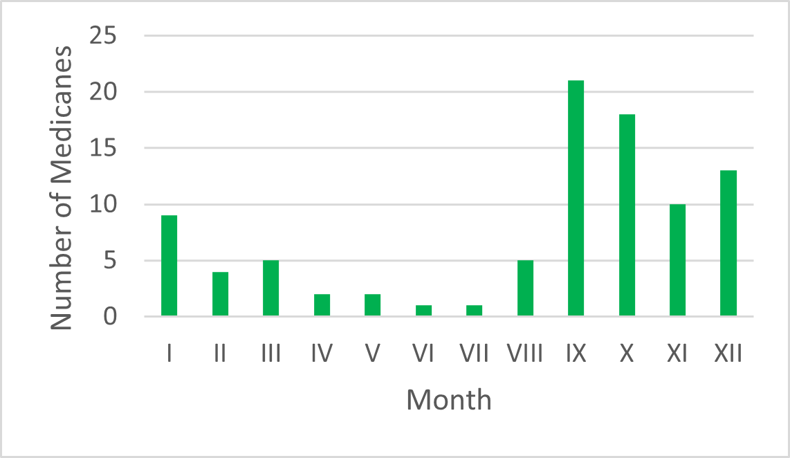
Figure 2: Monthly number of medicanes for the period 1947-2020.
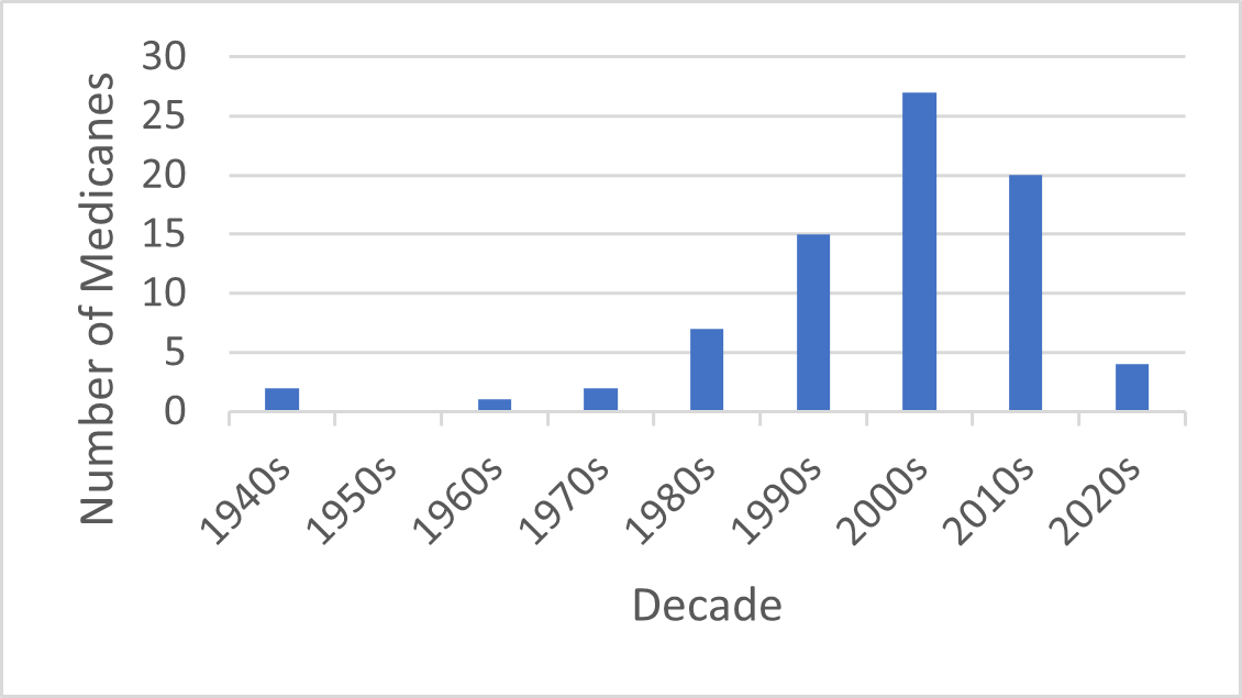
Figure 3: Number of observed storms in the Mediterranean Sea
Despite the growing interest of the scientific community in medicanes, until now there has been no strict consensus on the physical criteria that would qualify a Mediterranean cyclone as one. However, the most important ones, used by most authors, are the following:
- a frontless and axisymmetric structure
- a wind-free 'eye'
- an eyewall with deep convection and spiral cloud bands
- wind speed of at least 17 m/s, lasting at least 6 hours
Medicanes occur only rarely and special conditions have to be met for one to develop.
Upper-level low, 300 hPa jet stream, baroclinic processes, relative humidity.
Medicanes can develop when cold air intrusions move far southward over the Mediterranean. When a medicane forms, synoptic analysis will show the existence of an upper-level low followed by colder air in the middle and upper troposphere. Upper-level lows provide the energy required for intensifying atmospheric convection, while incursions of cold air will induce atmospheric instability.
The upper level low is often accompanied by a 300 hPa jet stream. It contributes to the synoptic forcing and brings dry air from the upper levels. It is one of the most important initiators of a medicane event. However, since medicanes derive only some of their energy from upper level winds - it will be shown later that latent heat release caused by convection is the dominant mechanism in later stages - a jet stream is not as important of a contributor in other stages. It is therefore strongest in the formation stage, while it weakens or even completely disappears in the later stages.
Baroclinic processes are also important mechanisms of formation and intensification. The baroclinic properties of the Mediterranean region, with its high temperature gradients, also provide the necessary instability for the formation of medicanes. In the first stage of their life medicanes are, similarly to ordinary winter storms, baroclinic disturbances which draw their energy from the available potential energy associated with large-scale horizontal temperature gradients.
Additionally, without high relative humidity in the lower and middle troposphere it would not be possible for medicanes to persist. Some authors state that low and middle tropospheric air with low relative humidity is like poison to medicanes.
The ingredients listed so far - cold upper lows accompanied by jet streams in a baroclinic environment with high relative humidity over the Mediterranean - are not uncommon, whereas medicanes are rare phenomena, suggesting that other favorable environmental factors are also necessary for these systems to undergo a transition to tropical-like dynamics.
Warm core, the 'eye' and convection
The main feature that distinguishes medicanes from 'normal' cyclones is the warm core - atmospheric temperatures in the center of the storm and around it are warmer than their surroundings.
In order to explain the meteorological factors that contribute to the formation of warm cores, many studies focused on air-sea interactions and on the consequent diabatic heating. Like hurricanes, medicanes are the result of a thermodynamic imbalance between sea and atmosphere. A warmer sea will supply more energy and release more heat in the upper troposphere, so the higher the sea-surface temperature (SST), the higher the probability of a transition to a warm core and thermodynamic intensification of the medicane. Air parcels lifted in such tropospheric conditions are very warm and moist at the beginning owing to evaporation from the warm sea. These parcels cool as they are lifted through a deep layer of the troposphere through large vertical displacements. In this process relative humidity increases until it reaches saturation and thunderclouds begin to form. However, that process releases latent condensational heat into the surroundings, which further increases relative humidity until saturation, which in turn releases more latent condensational heat. This feedback loop is what keeps the air within the medicane warmer than that at the same altitudes outside the medicane's influence.
The release of latent heat is a crucial factor in the formation of a medicane's warm core, but it is not the only one. As air in thunderstorm updrafts reaches the top of the troposphere, it moves away from the center, creating an area of divergence. In that way the weight of air columns near the center is reduced, which lowers pressure at sea level.
A warm core is not the only feature that distinguishes medicanes from ordinary cyclones.
The eye of a medicane, similar to the eye of a hurricane, is a region of relatively calm and clear weather at the center of the storm. The eye is typically circular or oval-shaped and is surrounded by a ring of towering thunderstorms known as the eyewall.
The development of an eye in a medicane is the result of the storm's circulation pattern. As air flows toward the center of a medicane, it is subject to the Coriolis force, which causes it to rotate counterclockwise in the Mediterranean area. This rotation creates centrifugal force that pushes the air outward, away from the center of the storm.
At the same time, the low pressure in the center of the storm creates a pressure gradient force that pulls the air inward, towards the center of the storm. These forces, along with the centrifugal force, are in balance, which causes the air to circulate in a circular pattern around the eye.
However, in the eye of the storm, the balance between these forces is disrupted. Because the centrifugal force is strongest at the edge of the eye, the pressure gradient force in the center of the eye is weaker than it is in the surrounding eyewall. This weaker pressure gradient force means that the air in the eye is not subject to as strong of an inward pull as it is in the eyewall.
As a result, the air in the eye is able to sink, rather than being forced upward by the strong upward motion that characterizes the rest of the storm. The sinking air in the eye is relatively dry and stable, which inhibits the formation of thunderstorms and clouds. This is why the eye of a medicane is typically characterized by clear skies and calm winds, even as strong winds and heavy rainfall continue in the surrounding eyewall. At the same time this air is warm because the warming occurs as air parcels compress in environments of higher pressure as they sink. This sinking and warming air over the center of the storm contributes to the medicane's warm core, but it also makes the tropical cyclone more intense because warmer air columns in the center of the storm are less dense, which further reduces sea-level pressure.
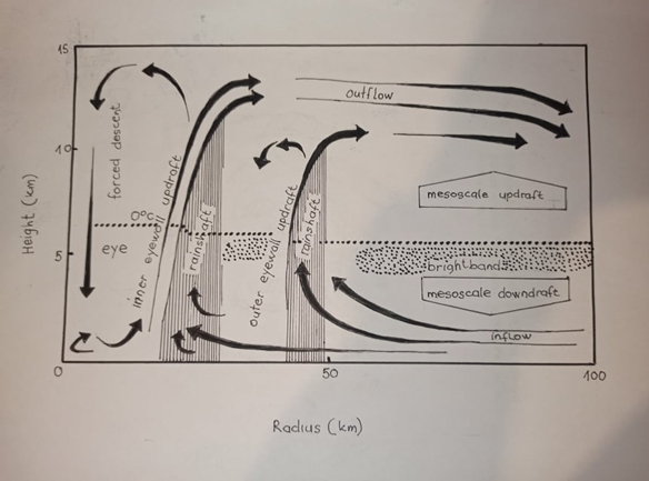
Figure 4: Schematics of medicane dynamics.
Convection is an important factor for medicane intensification in the ways described above. However, it is important to note that the convection in generally weaker in the mature stage of a medicane than in the formation stage. The first reason is in the existence of the eye. As the air in the eye sinks and warms, it creates a region of relatively dry and stable air that inhibits the formation of new convection. This can lead to a reduction in the overall intensity of the storm's convection, as well as a decrease in the amount of precipitation produced by the storm. In addition, as the storm continues to intensify, the structure of the storm's circulation can also change in a way that can lead to weaker convection. For example, the circulation of the storm can become more compact and concentrated, which can reduce the amount of upward motion in the storm's outer bands and eyewall. This can in turn lead to weaker convection and a decrease in the overall intensity of the storm.
The optimal conditions for medicane formation and intensification are complex and further depend on a number of other factors.
Temperature advection (TA), potential vorticity advection (PVA), vertical wind shear
Temperature advection is the transport of temperature by the atmospheric flow. It can play an important role in the formation and development of medicanes.
In the early stages of medicane formation, the presence of a warm and humid air mass over the Mediterranean Sea can create a thermally unstable environment that is favorable for the development of deep convection and thunderstorms. Temperature advection can help to transport this warm and humid air mass toward the region of low pressure, where it can rise and cool, leading to the formation of clouds and precipitation.
As the storm develops and intensifies, temperature advection can continue to play a role in the storm's dynamics. The transfer of heat from the underlying ocean surface to the atmosphere can help to fuel the storm's convection and maintain the low-pressure center.
In addition, temperature advection can influence the vertical structure of the storm's circulation. In regions where temperature advection is strong, air masses can be lifted and cooled more rapidly, leading to the formation of stronger updrafts and a more well-defined eyewall.
Potential vorticity advection can play an important role in the formation and intensification of medicanes.
Potential vorticity is a quantity that describes the rotation and stretching of air masses in the atmosphere. It is a conserved quantity on isentropic surfaces in the absence of friction, and is therefore a useful diagnostic tool for studying the dynamics of atmospheric flows. In regions where PVA is high, there is a tendency for air masses to rotate more rapidly and for the atmosphere to become more unstable.
In the context of medicanes, PVA can help to initiate and intensify the storm by promoting the formation of a low-pressure area at the surface. This occurs as PVA causes air masses to rotate more rapidly and converge into a small region, leading to the formation of a center of low pressure. As the air in the center of the storm rises, it cools and releases moisture, leading to the formation of clouds and precipitation.
In addition, PVA can help to intensify the storm's circulation by enhancing the transfer of heat and moisture from the underlying ocean surface to the atmosphere. This occurs as the stronger rotation and stretching associated with PVA creates a more favorable environment for the transfer of energy from the ocean to the atmosphere.
Vertical wind shear refers to the change in wind speed and direction with height in the atmosphere. Strong vertical wind shear can disrupt the organization of the storm's circulation and inhibit its development, while weak vertical wind shear can allow the storm to become more vertically stacked and intensify more easily.
In the case of medicanes, some studies suggest that weak vertical wind shear (lower than 4 m/s in the layer 850-250 hPa) is generally more favorable for the formation and intensification of these storms. This is because weak vertical wind shear can allow the storm to become more vertically stacked, which can enhance the transfer of heat and moisture from the underlying ocean surface to the atmosphere, and promote the development of deep convection and thunderstorms. Moreover, in the presence of weak vertical wind shear there is weak or no advection of the upper air temperature anomalies far from the surface low pressure center.
When these favorable circumstances coincide, the occurrence of warm-core Mediterranean tropical cyclones becomes possible in a conducive environment.