Meteorological Physical Background
Deformation in the wind field
In a changing wind field four different kind of variations can affect elements flowing in the field (such as clouds and humid areas): translation, divergence, vorticity and deformation. The correspondent changes in clouds and humid areas are:
| variation in the wind field | change to the cloud |
|---|---|
| Translation | location |
| Divergence | area |
| Vorticity | orientation |
| Deformation | shape |
- Translation shifts elements
- Divergence either contracts (convergence) or expands (divergence) elements
- Vorticity rotates elements either cyclonically (positive vorticity) or anticyclonically (negative vorticity)
- Deformation changes the shape of the elements
Mathematically the deformation D can be written as a sum of two components, stretching and shearing deformation (Dst and Dsh) as follows:
D = √Dst2 + Dsh2 , where in a (x,y)-plane
Dst = ∂u/∂x - ∂v/∂y and
Dsh = ∂u/∂y + ∂v/∂x,
u being the wind component in x-direction, v in y-direction.
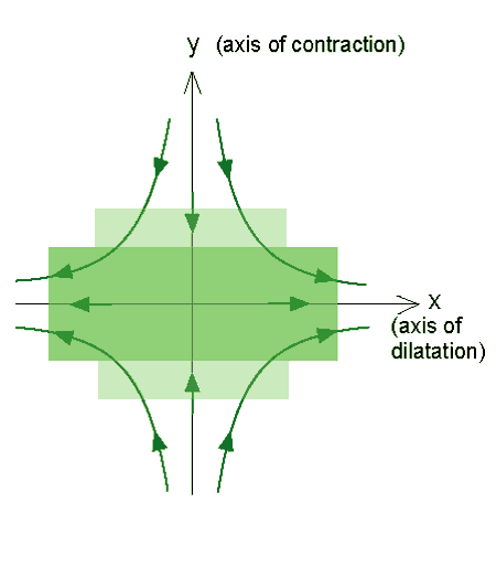
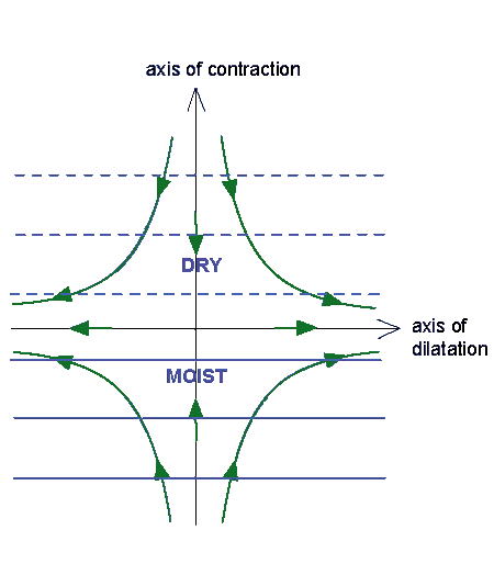
The effect of stretching and shearing terms can be represented schematically as follows:
|
Stretching deformation. Green lines and arrows show the wind field. Light green square is an element, which stretches into the
darker green rectangle. The area of the element stays the same. Here x-axis is the axis of dilatation and y-axis is the axis of
contraction.
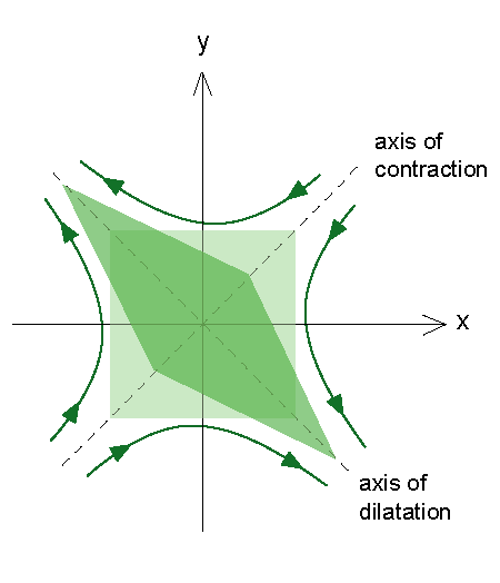
|
Shearing deformation. The situation is the same as on the left, but now the axes of dilatation and contraction are at 45° angle
to the x- and y-axes.
|
|
|
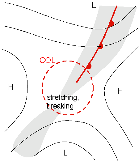
In the schematics above it can be seen that a col (saddle surface) and a confluent zone are required for the deformation to occur.
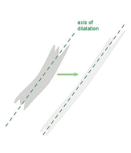
In the satellite images the stretching and shearing deformation can be pictured as follows:
|
Stretching deformation. A cloud band elongates uniformly. This is typical for occluded cloud bands.
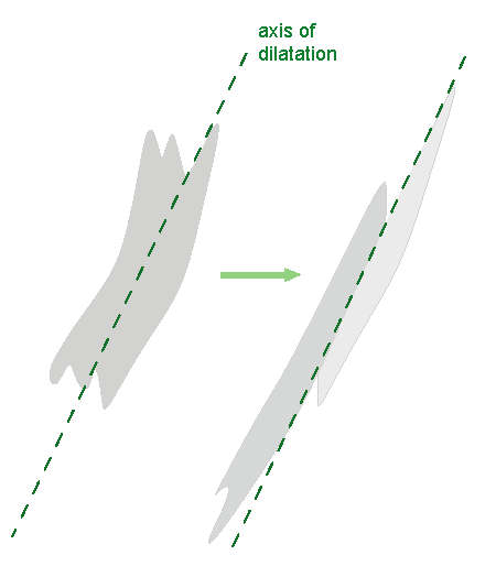
|
Shearing deformation. Different parts of a cloud band elongate in opposite directions. This can be seen e.g. in Cold Fronts.
|
|
|
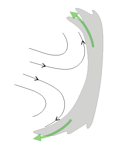
The col surface can also be half of a saddle, which leads to the formation of a "mushroom pattern" (a curved cloud band):
|
|
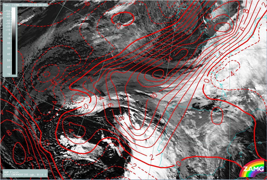
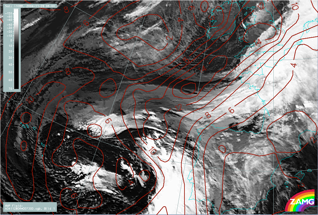
28 November 2004/06.00 UTC - Meteosat 8 IR 10.8 image; red solid: positive stretching deformation 300 hPa, red dashed: negative
stretching deformation 300 hPa
|
|
|
|
|
|
|
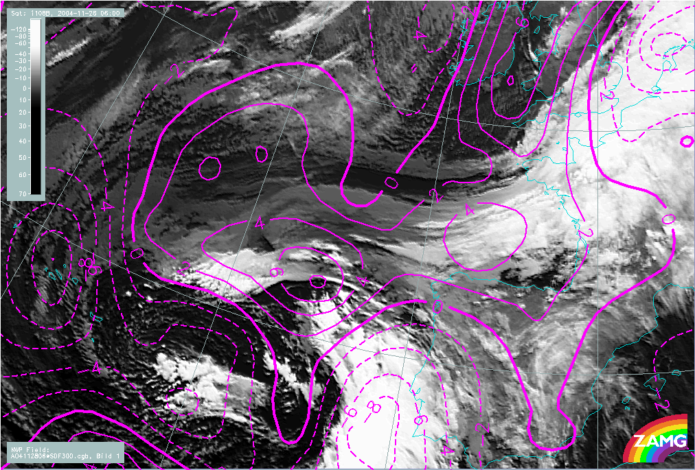
28 November 2004/06.00 UTC - Meteosat 8 IR 10.8 image; magenta solid: positive shear deformation 300 hPa, magenta dashed: negative
shear deformation 300 hPa
|
Typical locations for Deformation Bands
Deformation zones are generated by opposing flows. Typical situations in which deformation occurs, are those in which the cloud bands of two synoptic or meso-scale cloud systems are brought close to each other. Once they start merging, the elongation of the cloud band becomes obvious.
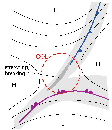
The location of deformation is most often a col (see sketches before). The maximum of a deformation field is nearly always in the confluent area of the wind field, on the colder side of it. At the saddle point the deformation is non-existent.
The most likely location is the area near the pole ward boundary of Warm Front and Occlusion cloud bands. Often a cold front approaches this cloud area from the north. The cloud bands merge, then they start to elongate. In the end the cloud band breaks somewhere in the middle of the band, and the rest of the cloudiness dissipates.
|
Deformation on a col with a Cold Front and an occluded front merging
|
Part of warm frontal cloudiness breaks off
|
|
|
Deformation zones are seen as linear structures with diverging moisture parcels along the line. The intensity of the deformation zone is proportional to the contrast in moisture gradient across the zone.
The moisture gradient is typically sharpest pole wards of the Deformation Band. Dry sinking air coming from the north is advected towards the axis of dilatation, which can be seen as a dark area in WV imagery. The contrast between dry and moist air is enhanced by the transportation of moist air from the south by the moist upper level conveyor belt.
|
|
28 November 2004/06.00 UTC - Meteosat 8 WV 6.2 image; blue solid: relative humidity 500 hPa > 70%, blue dashed: relative
humidity 500 hPa < 70%, green: streamlines 300 hPa
|
|
|
Deformation Bands and Frontogenesis
Deformation is a primary factor in frontogenesis and frontolysis.
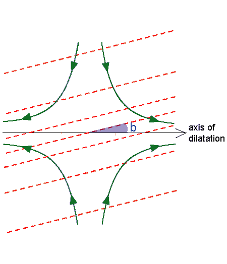
The full frontogenesis function Ft consists of three components: Ft = Fh + Fv + Fq, where Ft is frontogenesis caused by horizontal wind field, Fv frontogenesis by vertical motions and Fq frontogenesis by diabatic heating. The contribution from Fh is necessary for the formation of synoptic scale fronts. It can be expressed as:
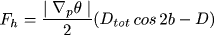
where Dtot is the total deformation, D is the horizontal wind divergence and b the angle between the axis of dilatation and the isentropes.
Frontogenesis can occur when cos2b > 0, which means that 2b < 90° or b < 45°. Frontolysis can occur when 45° < b <
90°.
Frontogenesis is strongest in the confluence zone, and zero in the saddle point, where there is no wind.
|
Frontogenesis
|
Frontolysis
|
|
|
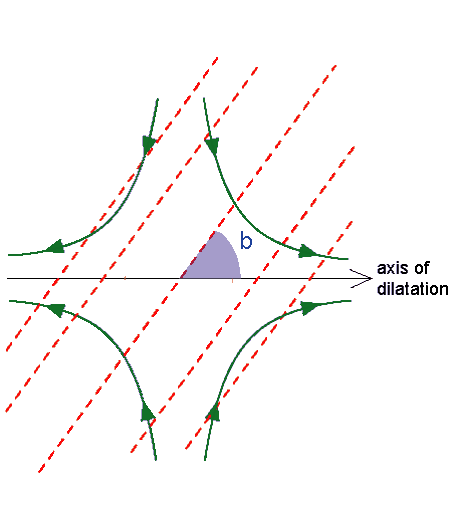
The effect of vorticity on the deformation field is shown the following diagram:
|
|
|
|
|
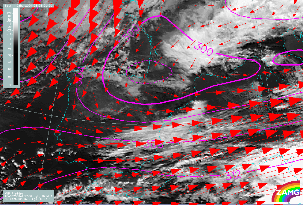
25 March 2004/06.00 UTC - Meteosat 8 IR 10.8 image; red: wind 500 hPa, magenta: equivalent potential temperature 500 hPa
|
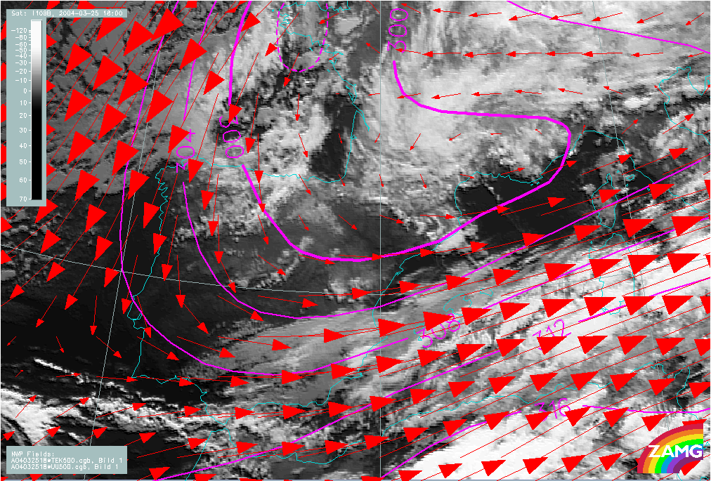
25 March 2004/18.00 UTC - Meteosat 8 IR 10.8 image; red: wind 500 hPa, magenta: equivalent potential temperature 500 hPa
|
Deformation Bands and Jet Fibres
Deformation Bands have a somewhat similar appearance to Jet Fibres towards the end their life cycle (see Jet Fibres ). Their origins and often also the locations with respect to jet streams, however, are different. The similarities and differences can be briefly listed as follows:
- Jet Fibres occur only in the vicinity of an upper level jet. Deformation Bands extends to areas with weak winds, usually a col.
- Jet fibres associated with a Cold Front occur only on the cold side of the front, whereas Deformation Bands are more likely on the warm side of a Cold Front.
- Jet Fibres have a typical life cycle ranging from 8 hours up to 24 hours. Deformation Bands have shorter life-cycles, due to the strong sinking motion that takes place at the poleward side of the cloud band. Typical life cycle for Deformation Band cloudiness is 6-9 hours.
- Both Jet Fibres and Deformation Bands have a dark stripe in WV imagery along the cold side of the cloudiness due to sinking motion at upper and middle troposphere.
- Jet Fibres experience deformation when they are brought into a deforming wind field. They should in this case be still classified as Jet Fibres due to their origin.
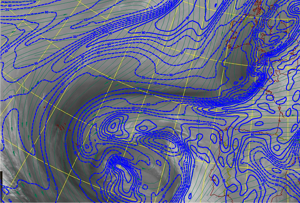
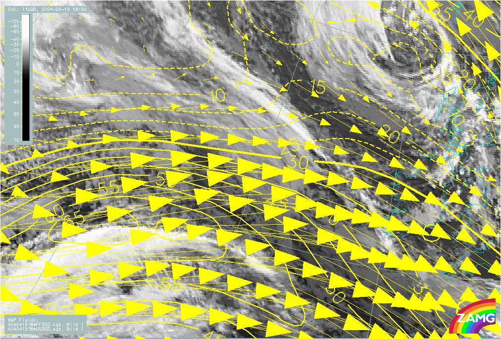
The example below illustrates a case showing Jet Fibres and Deformation Band over the Atlantic Ocean. The Deformation Band is within weak, but confluent upper level flow, whereas the Jet Fibres, more to the south, are clearly associated with a polar front jet streak.
|
19 April 2004/18.00 UTC - Meteosat 8 IR 10.8 image; yellow: isotachs 300 hPa; yellow arrows: wind 300 hPa
|
|
|