Table of Contents
Appearance in Satellite Data
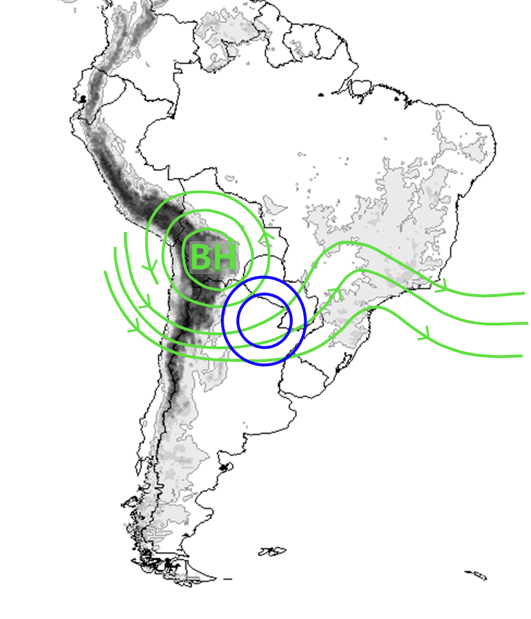
The presence of the Bolivian High (BH) and its position over the Bolivian Plateau influence the occurrence of different cloud types over the continent. In particular, this chapter refers to two cloud patterns observed in the satellite images at the southern flank of the Bolivian High:
-
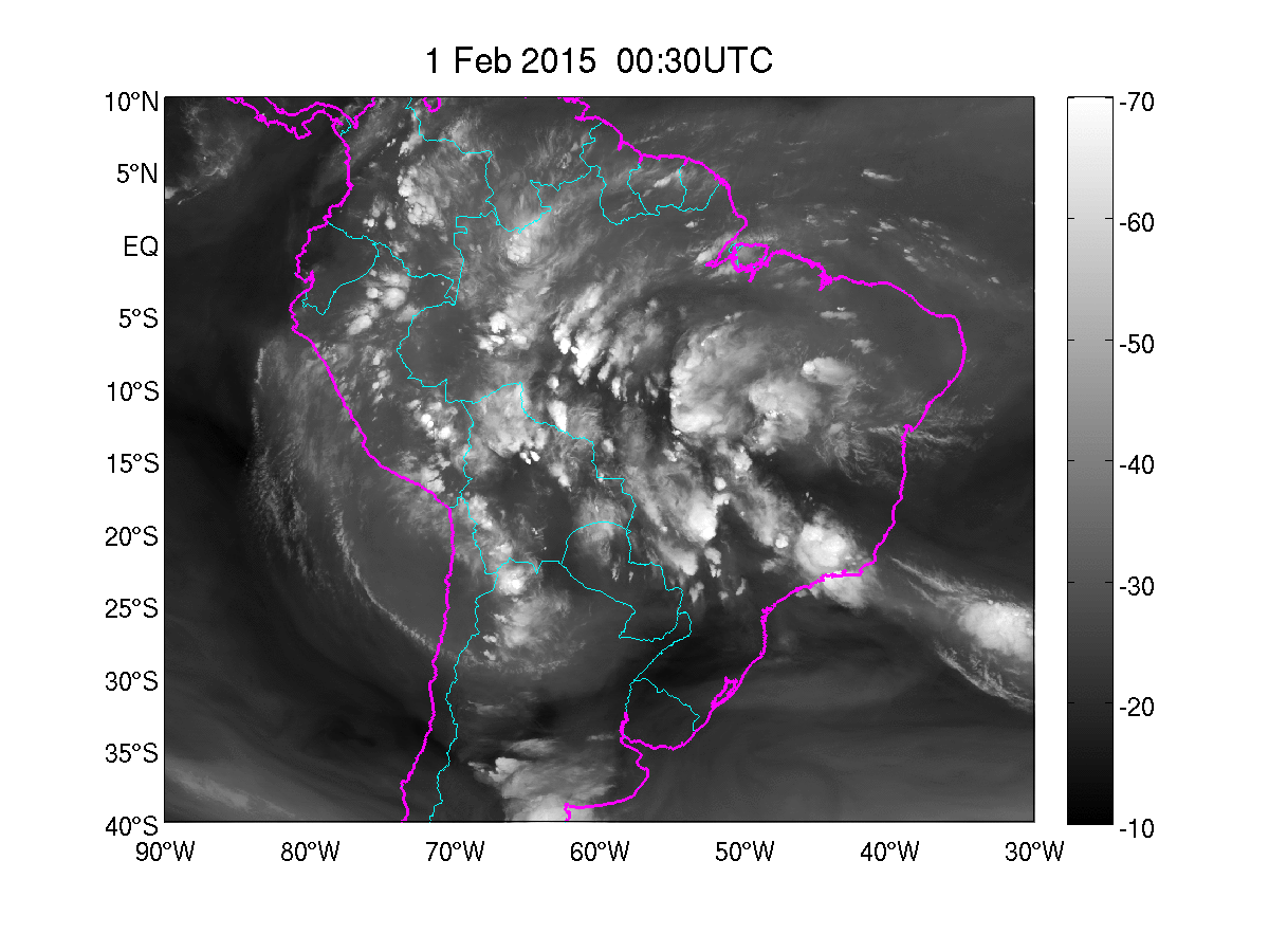
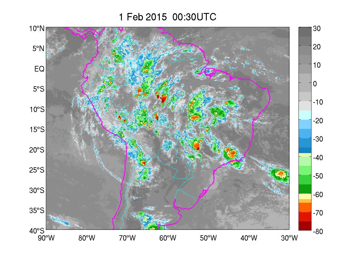
Narrow cirrus cloud bands:
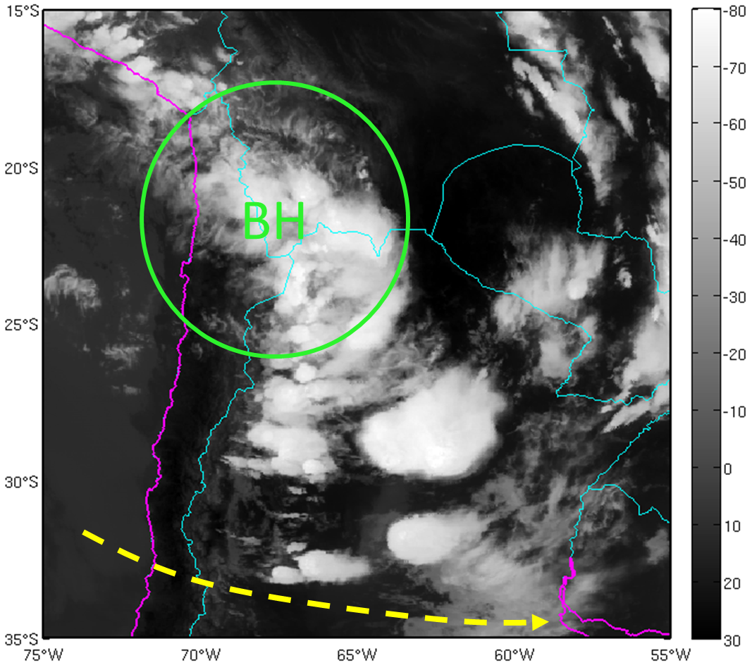
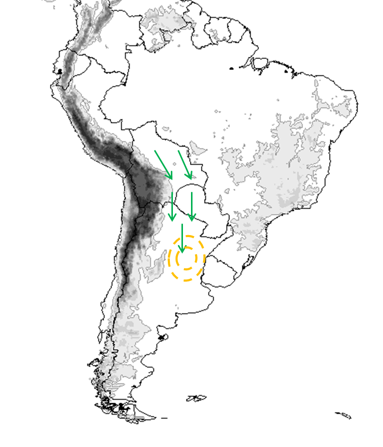
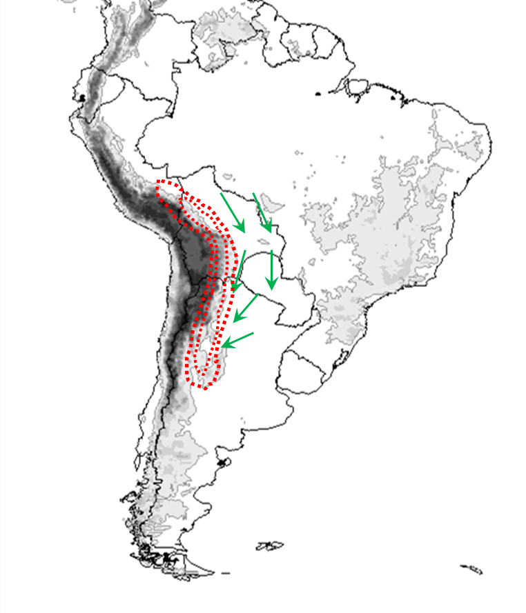
Cirrus clouds at high levels of the troposphere (300-200 hPa), entering the continent from the north of Chile, organized in narrow bands with anticyclonic curvature. Their orientation is generally parallel to the upper level wind and they are related to the presence of the subtropical jet stream in the polar sector of high level anticyclonic circulation. - Enhanced deep convection over northern Argentina:
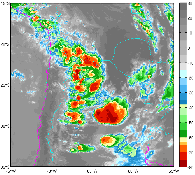
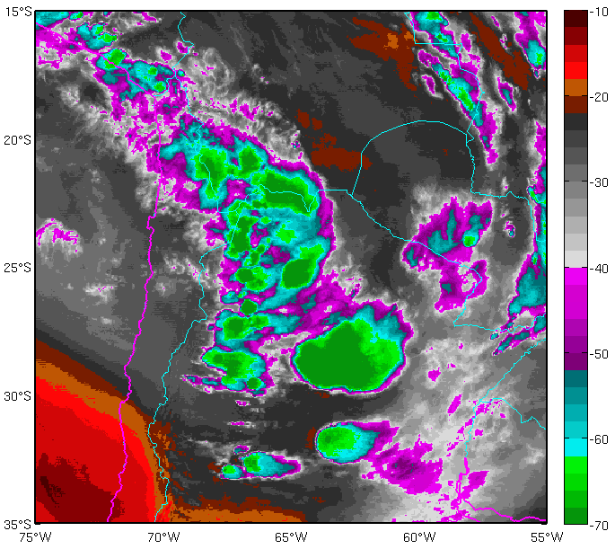
Cumulonimbus clouds with varying degrees of organization (isolated cells or clusters) form on the eastern lee of the Andes mountain range as a result of local circulations that develop during hours of maximum radiative heating. Deep convection is also enhanced over the plains of northeastern Argentina by the upper-level divergence of the BH.
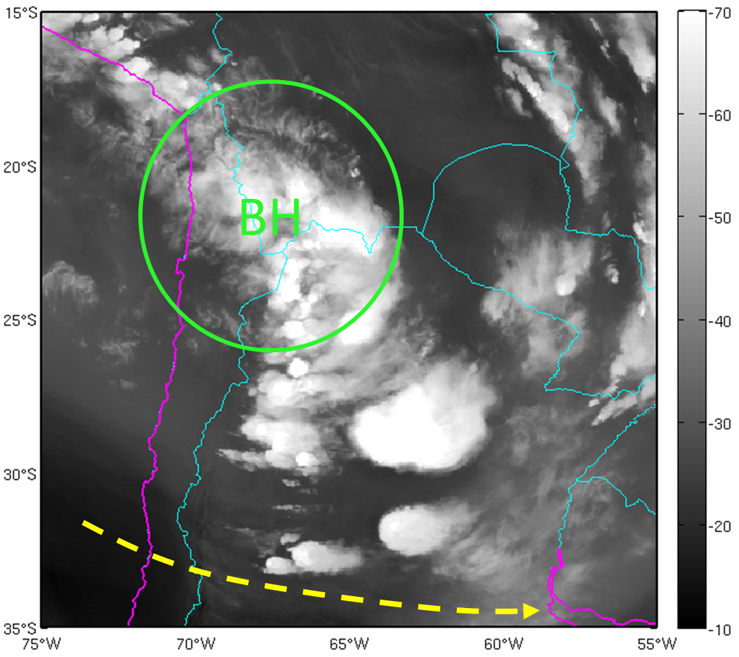
1. Narrow cirrus cloud bands
|
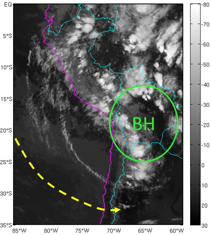
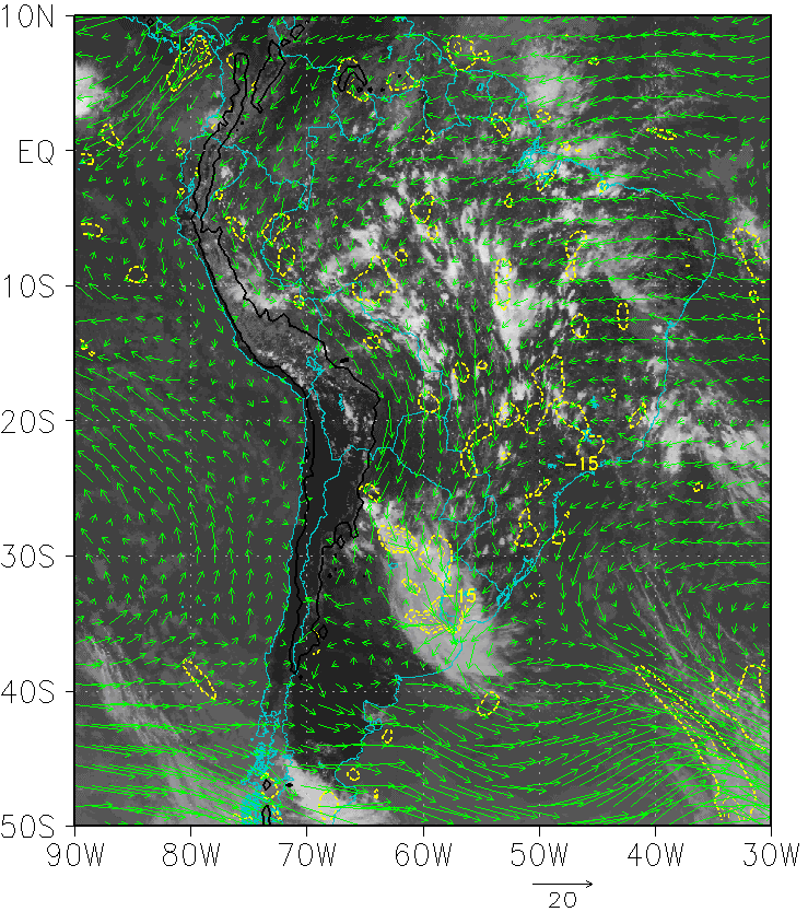
01 February 2015/00.30 UTC - GOES 13 IR 10.7 image
|
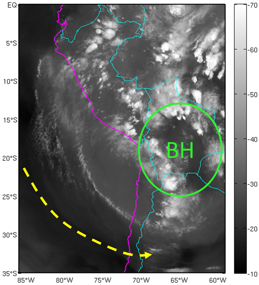
01 February 2015/00.30 UTC - GOES 13 WV 6.75 Image
|
|
|
|
01 February 2015/00:30 UTC - GOES 13 IR 10.7 enhanced image
|
01 February 2015/00:30 UTC - GOES 13 WV 6.75 enhanced Image
|
|
|
2. Enhanced deep convection over northern Argentina
|
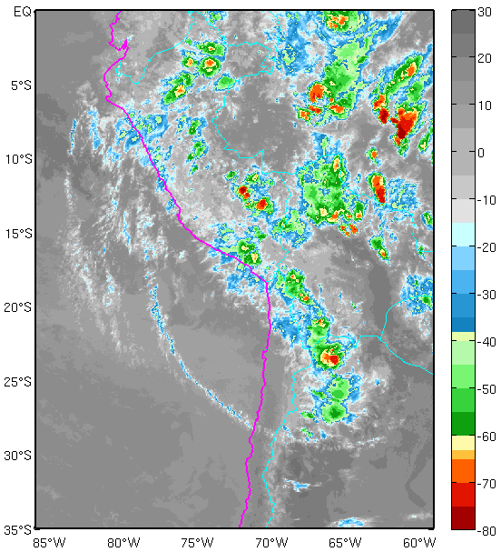
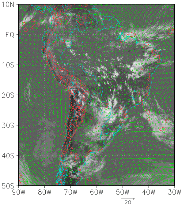
02 February 2015/22.30 UTC - GOES 13 IR 10.7 image
|
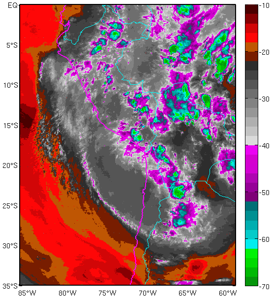
02 February 2015/22.30 UTC - GOES 13 WV 6.75 image
|
|
|
|
02 February 2015/22.30 UTC - GOES 13 IR 10.7 enhanced image
|
02 February 2015/22.30 UTC - GOES 13 WV 6.75 enhanced image
|
|
|
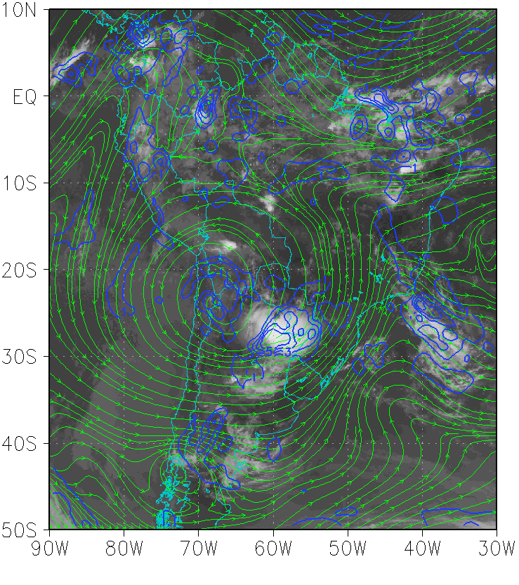
The following animation shows the upper level circulation and clouds associated with the BH during 1 February, 2015.
|
Press "Play Button" to see the loop; 1 February 2015 00:00-23:30 UTC. GOES 13 WV 6.75. |
|
Press "Play Button" to see the loop; 1 February 2015 00:00-23:30 UTC. GOES 13 IR 10.7. |
Meteorological Physical Background
Mean circulation and vertical structure
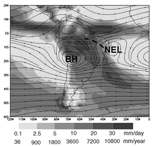
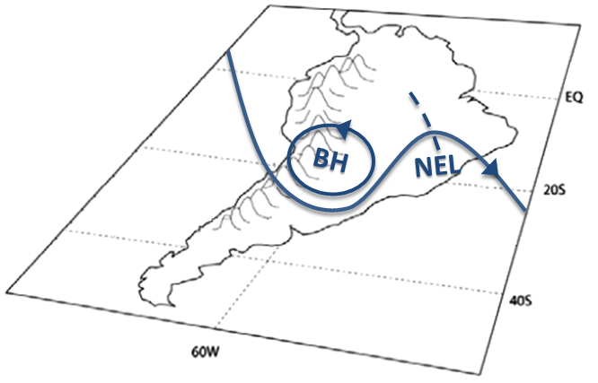
The upper-tropospheric circulation over South America during the summer is characterized by a quasi-stationary wave made by the BH, a trough to the west, over the Pacific Ocean, and one to the east, over northeastern Brazil, known as the Northeast Low, NEL.
The BH has its climatological center located at approximately 17°S - 70°W and it is an important component of the South American Monsoon System (SAMS) in its mature stage.
|
Mean circulation at 200 hPa and accumulated precipitation in summer in the southern hemisphere. (Figure adapted from Garreaud, Aceituno, 2007)
|
|
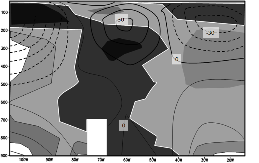
In terms of its vertical structure, the BH presents a warm core below 150 hPa, with a maximum at 300 hPa. Lenters (1997) suggests that the presence of this core is due to subsidence in the western coast of South America. The BH presents a thin layer of cold air above 150 hPa, to the west of the area with large scale deep convection with overshooting tops of Cb's over the Amazon Basin. Adiabatic cooling takes place within the easterly flow. Adiabatic cooling takes place within the easterly flow, which leads to the movement of the cold layer west of the overshooting tops.
|
Vertical Cross Section of geopotential height anomaly (contours) and temperature anomaly (shaded). The white line indicates the 0°C isotherm and the darker shadings indicate higher temperatures. The region depicted in the figure lies between between 10°S and 25°S. (Figure adapted from Lenters y Cook, 1996).
|
|
Overview of the regional-scale features related to the Bolivian High
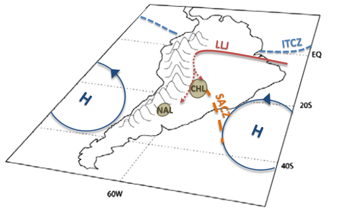
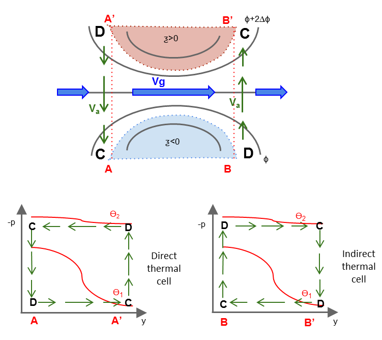
Two semi-permanent low pressure systems are related to the upper level BH. It has two different centers: the Chaco Low (CHL) northwest of Argentina, which is a warm core low located between Paraguay and Bolivia, and the Northwestern Argentina Low (NAL). While the structure of the CHL depends on thermal processes, the NAL encompasses both thermal and orographic processes (Saulo et al., 2010).
By the end of November CHL intensifies generating an increase in the pressure gradient between the center of South America and the northwest of Sahara, Africa. As a result of this, the intensity of the trade winds increases, producing an anomalous positive humidity flow towards the South American continent. The winds entering from the northeast are forced towards the south by the Andes, thus forming the South American Low Level Jet (SALLJ). These low level winds advect humid air. As a result, precipitation over Amazonia, central and southeastern Brazil and the South American Convergence Zone (SACZ) is increased.
At high levels, the BH and NEL make up a quasi-stationary short wave system which is intensified by the upward movement of the convective activity over Amazonia, the SACZ and the Central Andes. Moisture convergence at low levels and the latent heat release at mid-levels help sustain the upward movement and maintain a high and relatively warm troposphere in the region. These features are typical of the South American Monsoon System (Vera et al., 2006).
Contrary to what might be thought, studies such as Gandu and Silva Dias (1998) and Lenters and Cook (1997) show that the elevation of the Andes does not directly and significantly affect upper level circulation. Simulations indicate that the BH is formed even in the absence of the Andes. In spite of this, the mountain range indirectly intensifies the anticyclone by inducing precipitation in the Central Andes and by modifying precipitation in other regions.
|
Surface circulation associated with the Bolivian High
|
Upper level circulation associated with the Bolivian High
|
|
|
Seasonal variability of the Bolivian High
The seasonal variations of the BH are closely linked to the different stages of the South American Monsoon System.
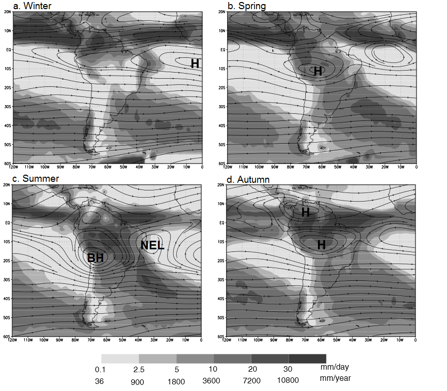
- Winter: the area of heavy precipitation located in the north of South America is related to the position of the ITCZ. The upper level anticyclonic center is not present over the continent.
- Spring: at surface level, the easterly flow moves towards the south, advecting humidity and displacing the area of heavy precipitation towards the center of Amazonas. A weak anticyclonic center related to this convective activity starts forming over South America, slightly to the north of the climatological position of the BH. These shifts in precipitation and upper level circulation trigger the South American monsoon.
- Summer: during the mature stage of the monsoon, precipitation reaches its maximum value in the center of South America, Central Andes and over the SACZ. The BH is intensified in response to this convection and the release of latent heat, and settles over the Bolivian plateau. The cyclonic center which forms over northeast Brazil downstream of BH is the NEL.
- Autumn: polar systems entering the continent lead to a decrease in moisture and rapid decrease in available latent heat. This, together with the sun's shift northwards of the equator, causes the weakening of the subtropical ridge/BH. NEL is no longer present and the monsoon weakens.
|
Mean seasonal precipitation (shaded) and stream function at 200 hPa for southern hemisphere (a) Winter (June-July-August), (b) Spring (September-October-November), (c) Summer (December-January-February), and (d) Autumn (March-April-May). H: high pressure system , BH: Bolvian High and NEL: Northeastern Low. Figure adapted from Garreaud and Aceituno, 2007.
|
|
Four typical upper level circulation patterns of the BH
The position and shape of the BH are modified by precipitation and different components of the atmospheric circulation. Ferreira et al. (2004) identify four types of configurations:
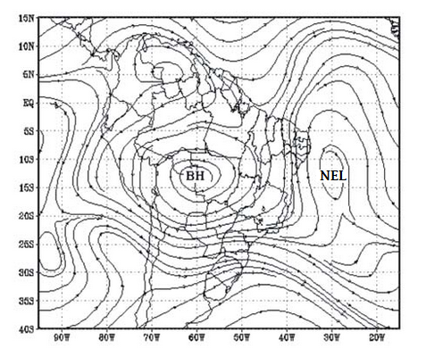
a) Bolivian High - Northeast Low
|
Stream function at 250 hPa, for January 2, 1999. (Adapted from Ferreira et al., 2004)
|
|
|
b) Bolivian High - Northeast low - Anticyclonic Center
|
Stream function at 250 hPa, for January 7, 1999. (Adapted from Ferreira et al., 2004)
|
|
|
c) Bolivian High -Anticyclonic
|
Stream function at 250 hPa, for January 19 , 1999. (Adapted from Ferreira et al., 2004)
|
|
|
d) Bolivian High - Trough
|
Stream function at 250 hPa, for January 12, 1999. (Adapted from Ferreira et al., 2004)
|
|
|
|
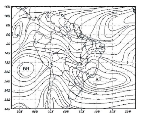
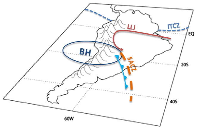
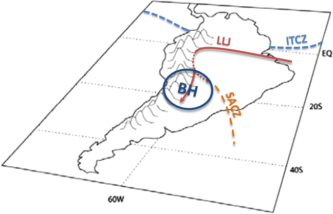
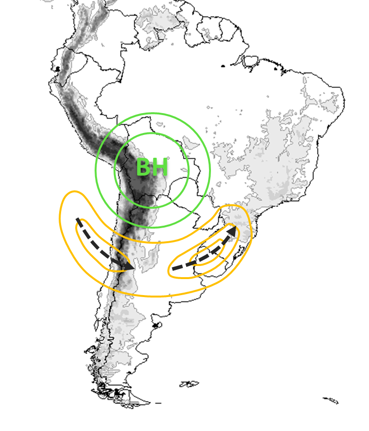
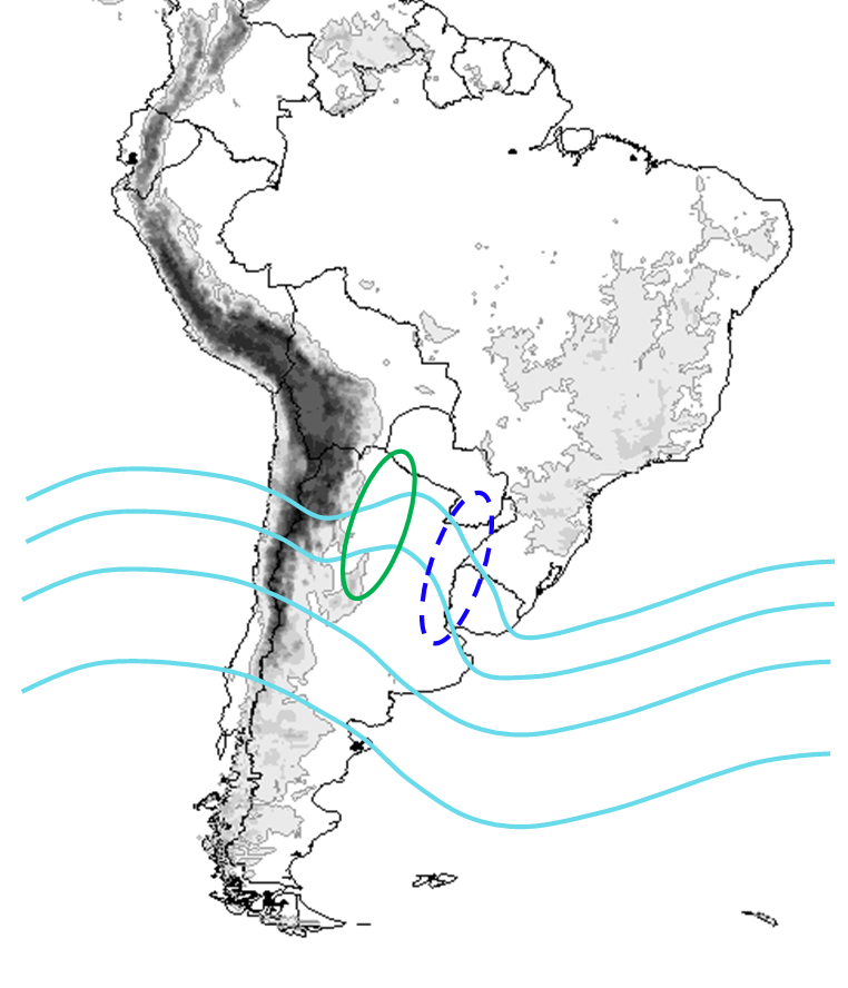
Interaction with SACZ
Numeric simulations have shown that precipitation in SACZ modulates the intensity and position of the BH. The pattern that is responsible for the mutual influence between convection in the SACZ and the BH is known as the South American SeeSaw (SASS) Dipole.
a) SASS negative phase
|
When frontal systems reach southeastern Brazil, strong convergence at low levels increases the humid westerly flow deflecting the SALLJ towards the SACZ region. Under these conditions, convection over the SACZ is intensified and well organized, and extends to the southeast. Strong compensation subsidence inhibits precipitation over Paraguay, Uruguay and the subtropical regions of Argentina and Brazil. All these changes in the precipitation fields over South America weaken the BH and shift it to the west from its climatological position. |
b) SASS positive phase
|
When the SACZ is weakened and to the south of its climatological location, the low level jet acquires an intense southern component along the east of the Andes. The BH is intensified and centered over the Bolivian Plateau. |
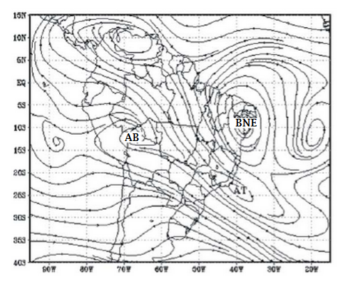
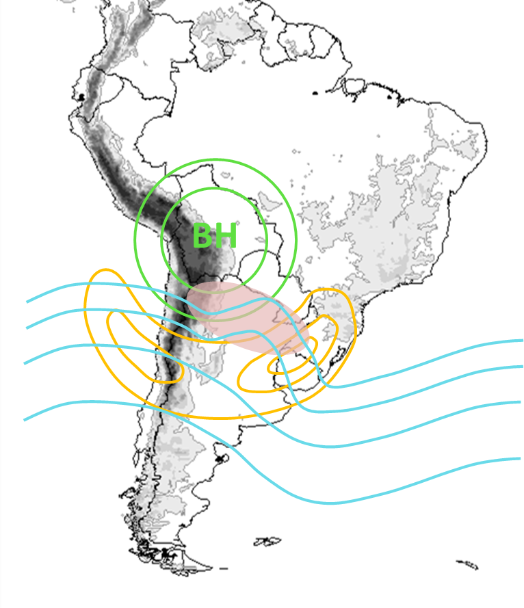
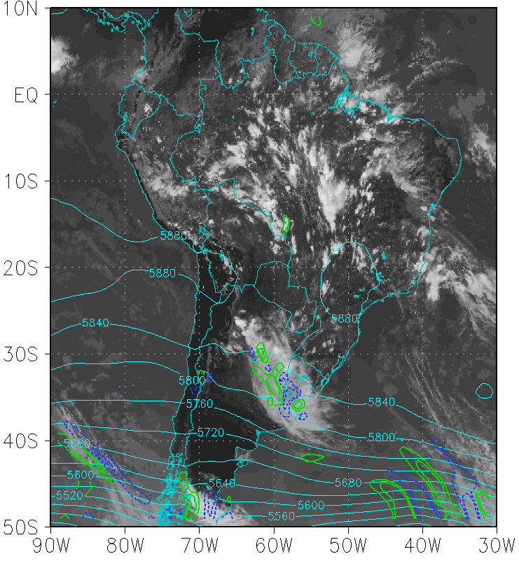
Interaction between the Bolivian high and deep convection over northern Argentina
The BH may help to develop deep convection, especially in its periphery, due to the presence of diffluent and divergent flows.
|
Green: Geopotential height at 200 hPa
Orange: Isotachs at 200 hPa Light blue: Geopotential at 500 hPa Shaded red area: enhanced convection |
|
Therefore two mechanisms may contribute to convective development:
a) Interaction with a mid-level short wave:
A short-wave trough moving south of the BH may generate sufficient divergence to cause the development of explosive convection and mesoscale convective systems (when other atmospheric parameters are favorable) over northern Argentina and southern Brazil.
b) Formation of intense high level jet:
A short-wave trough moving south of the BH may generate sufficient divergence to cause the development of explosive convection and mesoscale convective systems (when other atmospheric parameters are favorable) over northern Argentina and southern Brazil.
|
Other mesoscale factors, such as convergence lines, gravity waves, convective rolls at the planetary boundary layer and surface inhomogeneities also affect the triggering of convection. These mechanisms play an essential role particularly in the northwestern region of Argentina, where they lead to a development of local circulations associated with the topography and the radiative heating (Vidal, 2014). Also, in this region the lee side perturbations of the airflow nearly perpendicular to the northern Andes of Chile can provide the triggering mechanism for diurnal convection.
Key Parameters
Intensified upper level jet with anticyclonic curvature:
- Geopotential height at 200 hPa: closed circulation center located over Bolivia or north of Argentina (Bolivian High, BH).
- Isotachs at 200 hPa: upper level jet with anticyclonic curvature. Two jet streaks located to the south of the BH.
- Streamlines and divergence at 200 hPa: diffluent flow and maximum divergence on the southeast side of the BH.
Interaction with mid-level short wave:
- Omega at 500 hPa: maximum upward movement southeast of the BH.
- Geopotential height at 500 hPa: short wave at mid-levels located south of the BH.
- Humidity convergence at 850 hPa: humidity convergence to the SE of the BH in the north of Argentina.
- Wind vector at 850 hPa: northerly meridional wind over the north of Paraguay and Argentina in connection with SALLJ.
Interaction with local forcings:
- Wind vector at 925 hPa: low level convergence along the Andes.
- Omega at 925 hPa: maximum upward movement on the eastern slopes of the Andes.
Note: These key parameters correspond to two different case studies.
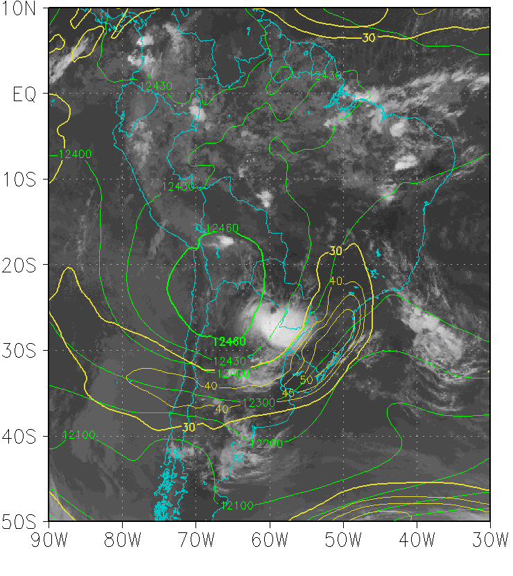
Geopotential height and isotachs at 200 hPa
|
03 February 2015/12:00 UTC - GOES 13 IR 10.7; green: geopotential height at 200 hPa, yellow: isotachs at 200 hPa
|
|
|
|
Streamlines and divergence at 200 hPa
|
03 February 2015/12:00 UTC - GOES 13 IR 10.7; green: streamlines at 200 hPa, blue: divergence at 200 hPa.
|
|
|
|
Geopotential height and vorticiy advection at 500 hPa
|
03 March 2015/18:00 UTC - GOES 13 IR 10.7; cyan: geopotential height at 500 hPa, blue: NVA at 500 hPa, green: PVA at 500 hPa.
|
|
|
|
Humidity convergence and wind vector at 850 hPa
|
03 March 2015/18:00 UTC - GOES 13 IR 10.7; green vector: wind at 850 hPa, yellow: humidity convergence at 850 hPa.
|
|
|
|
Omega and wind vector at 925 hPa
|
03 February 2015/18:00 UTC - GOES 13 IR 10.7; green vector: wind at 925 hPa, red: omega at 925 hPa.
|
|
|
|
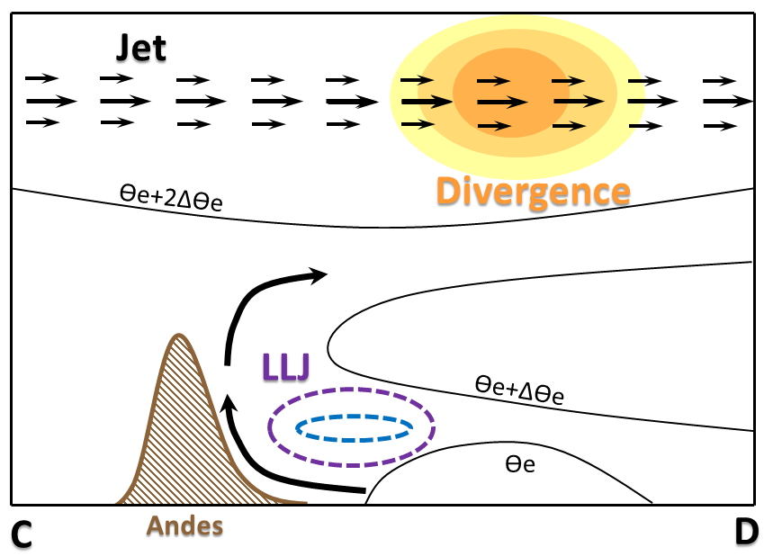
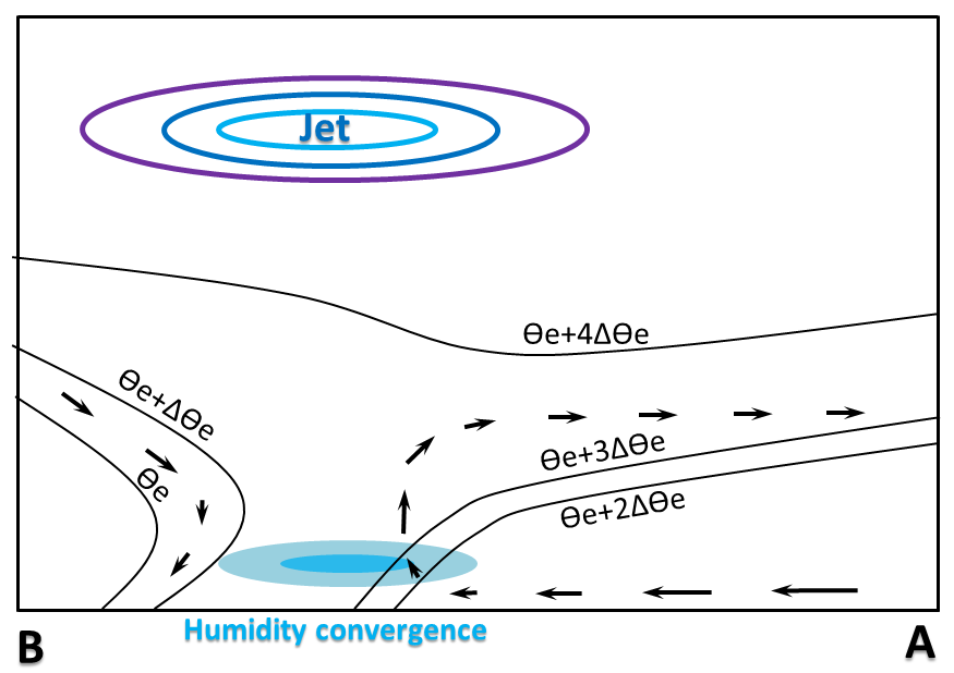
Typical Appearance In Vertical Cross Sections
- Wind: The upper level jet stream is observed east of the Andes at 200 hPa.
- Divergence: positive values at upper levels, east of the Andes, associated with the cyclonic curvature of the jet stream and the flow diffluence.
- Humidity convergence: maximum at low levels due to the deacceleration of the north wind.
- Equivalent potential temperature: light tightening of the isentropes showing the presence of a warm front.
|
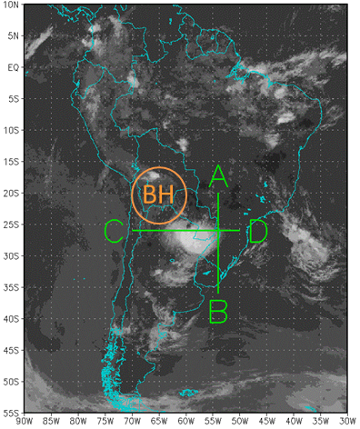
Locations of the vertical cross sections
|
|
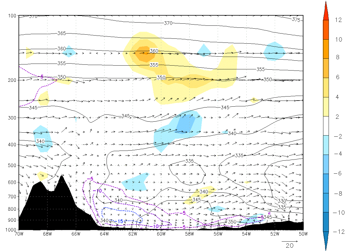
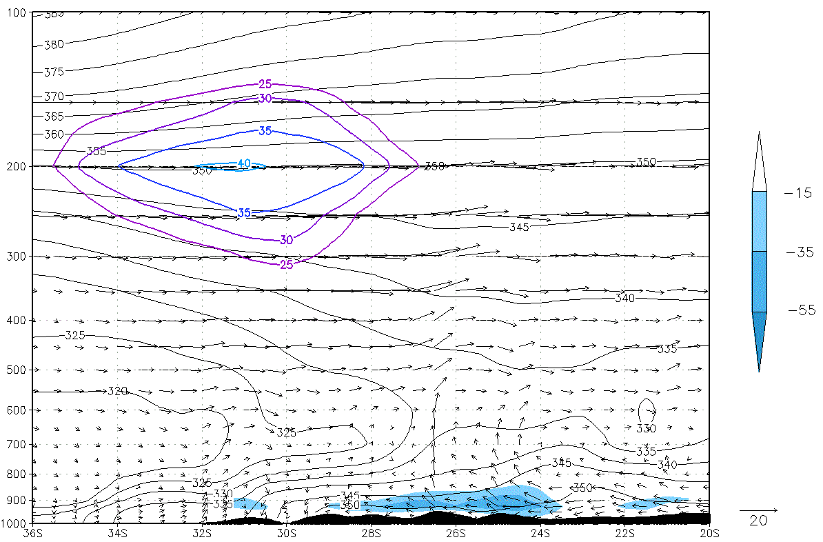
Zonal vertical cross section C - D
|
Lat 26°S: 03 February 2015/12:00 UTC. Shaded: divergence (10-5 s-1), black contours: equivalent potential temperature (K), dashed contours: meridional wind less than -5 m/s, arrows: zonal circulation.
|
|
|
|
Meridional vertical cross section B - A
|
Lon 54°W: 03 February 2015/12:00 UTC. Shaded: humidity convergence (g kg-1 day-1), black contours: equivalent potential temperature (K), violet contours: zonal wind above 25 m/s, arrows: meridional circulation.
|
|
|
|
Weather Events
These weather events are mainly associated with enhanced deep convection activity along the eastern flank of the Bolivian High. More specifically, the following parameters are described as they occur in the northern Argentina.
| Parameter | Description |
|---|---|
| Precipitation |
|
| Temperature |
|
| Wind (incl. gust) |
|
| Other relevant information |
|
|
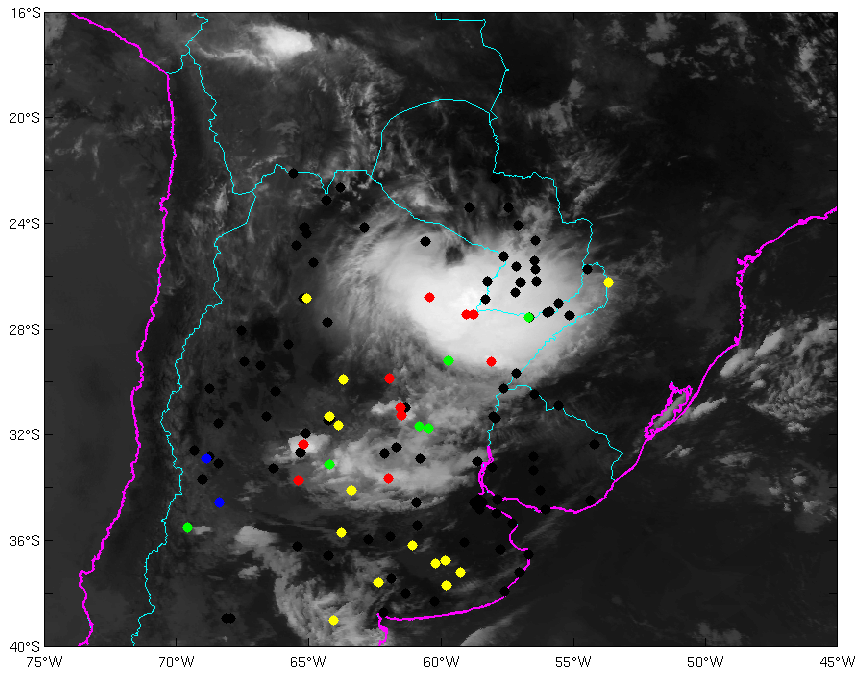
03 February 2015/12:00 UTC - GOES 13 IR 10.7 image; weather events (green: rain, blue: drizzle, red: thunderstorm, yellow: fog, brown: dust, black: no actual precipitation or present weather report)
|
03 February 2015/12:00 UTC - GOES 13 IR 10.7 image; cloud type observations from SYNOP reports (yellow dot: no present weather report).
|
|

|
|
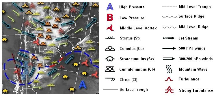
03 February 2015/06.00 UTC - GOES 13 IR 10.7 image; nephanalysis (generated by National Meteorological Service of Argentina)
|
|
References
General Meteorology and Basics
- Ferreira, N. J., Correia, A. A., and Ramírez, M. C. V., 2004: Synoptic scale features of the tropospheric circulation over tropical South America during the WETAMC TRMM/LBA experiment. Atmósfera, vol. 17, num. 1, pp. 13-30.
- Gandu, A. and Silva Dias, P. L., 1998: Impact of tropical heat sources on the South American tropospheric upper circulation and subsidence. Journal of Geophysical Research, Volume 103, Issue D6, pp. 6001-6015
- Garreaud, R. and Aceituno, P., 2007: The Physical Geography of South America, Chapter 3. Oxford University Press.
- Kousky, V. E., and Gan, M. A., 1981: Upper tropospheric cyclonic vortices in the tropical South Atlantic. Tellus (1981),33,538-551.
- Lenters, J. D. and Cook, K. H., 1997: On the origin of the Bolivian high and related circulation features of the South American climate. Journal of the Atmospheric Sciences 54.5: 656-678.
- Saulo, C., Ferreira, L., Nogués-Paegle, J., Seluchi, M., and Ruiz, J., 2010: Land-Atmosphere Interactions during a Northwestern Argentina Low Event. Mon. Wea. Rev., 138, 2481-2498. http://dx.doi.org/10.1175/2010MWR3227.1
- Uccellini, L. W., and Johnson, D. R., 1979: The coupling of upper and lower tropospheric jet streaks and implications for the development of severe convective storms. Mon. Wea. Rev., 107, 682-703.
- Vera, C., and Coauthors, 2006: Toward a unified view of the American Monsoon Systems. J. Climate, 19, 4977-5000.
- Vidal, L., 2014: Convección extrema sobre Sudamérica: estructura interna, ciclos de vida e influencia de la topografía en la iniciación. PhD dissertation, University of Buenos Aires.