Transformation Phase
Around 46% of North Atlantic hurricanes transition.
The transition season typically runs from June to December and is a balance between atmospheric and ocean processes.
The Eady zone for baroclinicity reaches maximum latitude in July before pushing southwards from August onwards due to atmospheric cooling.
Sea temperatures, however, lag a couple of months behind due to their slower response to solar heating fluxes, reaching a peak in September.
These two critical factors for each component are therefore out of phase, with 2 important results:-
- at the start of the season the critical sea temperatures for tropical cyclone development are some distance from the baroclinic zone. Hurricanes therefore have a greater distance to travel before reaching areas of development and ET is therefore less likely.
- the maximum northward extent of ET is pinched off in July by the southward migration of the jetstream, but from this time ET is more likely .
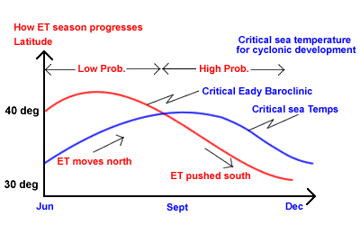
Figure 1.
Deep tropical cyclones are more likely to reintensify after transition than those that develop in the sub-tropics. Due to the higher sea temperatures and their longer track in the deep tropics they have more time to develop and are charcterised by lower surface pressures. Hurricane Conference (2000). For this reason they can also spend longer in the transitional phase than less intense storms and as a result are more likely to enter an area of favourable development. Hart and Evans (2001).
It is important to recognise that these are average values. Year on year variations occur due to climatic factors such as ENSO and NAO, both of which tend to reduce ET slightly in their respective positive phases, either due to a reduction in hurricane activity or increased upper level shear.
The time of transformation can be difficult to forecast accurately several days in advance, principally due to the uncertainty of the tropical cyclone track over the same timescale.
It can also be difficult to model because of :-
- a) the structural unknowns, the cyclone having originated and tracked over oceanic/data sparse areas.
- b) the rapid changes in this structure that occur during the transformation phase.
- c) the contrast between a relatively compact, self-contained cyclone and an expanding, interacting mid-latitude depression.
- d) Some of the physical processes of the ET process are as yet still uncertain.
During the transformation phase, the hurricane migrates away from the anticylconic steering flow of the Bermuda High and accelerates under the influence of strengthening broadly westerly zonal winds.
If this jet is too strong the organised convective cell structure / PV tower will rapidly break down due to vertical wind shear before the storm can interact with potential sources of development, such as an upper trough.
If the jet is too weak the hurricane will move only slowly over colder ocean temperatures. The tropical cyclone’s energy source is cut off and any remaining structure then dissipates before it reaches a development area.
At the same time, the advection of the warm core ( low level +PV / high level –PV) over progressively lower sea surface temperatures moves the storm into, and further enhances, a region of thermal contrast / baroclinicity with a resultant increase in tropospheric gradient and jetstream strength.
transform.gif ![]()
Figure 2. Transformation Phase.
Conclusion
Seasonal / climatological variations (eg La Nina/ El Nino), position of formation, time of year, sea temperatures, storm track and storm longevity can all help determine the characteristics of transition and the degree of any reintensification.
Forecast uncertainties are frequently high!
By the 5 th August, Alex was beginning to accelerate away to the northeast.