Transformation Phase
In this section we will be looking at the current theory of Extra tropical Transition.Although this phenomena is understood to take place, there is currently no universally accepted definition of extra tropical transition of tropical cyclones [(ET)] (Malmquist 1999).
This is despite the fact that, on average, 46% of Atlantic tropical storms (Hart and Evans 2001),
27% of western North Pacific storms (Klein et al. 2000),
and 10% of storms in western Australian waters (Foley and Hanstrum 1994) undergo ET.
For this aspect of the case study we have used the theories and arguments given by Hart and Evans in their paper "Objective Indicators of the Life Cycle Evolution of Extratropical Transition for Atlantic Tropical Cyclones" 2001. Evans and Hart assessment of extra tropical transition suggest that "In summary, a storm undergoing ET will exhibit an increasingly asymmetric thermal field in response to its interaction with the baroclinic midlatitude environment and will develop a cold-core structure, traceable through its thermal wind profile. Consequences of these structure changes include intense rainfall and extreme ocean waves, but the storm structure changes described suggest straightforward ET diagnostics based on height/thickness fields."

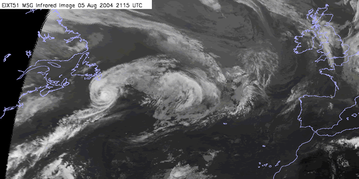
05 Aug 2004/12:15 UTC - MSG IR10.8 image
|
WV Imagery (Meteosat 8 channel 7.3): time sequence
Water vapour imagery is an important forecasting tool which enables us to observe the broadscale patterns such as jets and upper features. During this section we will describe the broadscale patterns and feature apparent during the tropical phase.
IR and WV Imagery (Meteosat 8 channel 10.8, 6.2, 7.3) and MSLP: time sequence
In this chapter we will use the Meteosat IR image and images of both WV channels combined with the surface analysis overlays to establish the surface pressure fields and movement of the system.
Air mass RGB : time sequence
The air mass RGB is used to enable us to analyse the broadscale features such as the jet and trough, ridge placement.
Summary of the investigations in this chapter
In this chapter some important things should be summarised before going on:
During transformation the cyclone is accelerating under the increasing influence of the mid-latitude "westerlies". These begin to strengthen from the end of July/early August, in response to high latitude radiative cooling and the resultant increase in thermal contrast. If the jet is too weak the hurricane will move only slowly over colder ocean temperatures. The tropical cyclone's energy source is cut off and any remaining structure then dissipates before it reaches a development area.
Study the area of transition on appropriate satellite imagery such as:-
- Large scale convection
- Frontal development
- Jet enhancement
- Storm accelerating
- Reduction in organised convection in the inner core region.
- Tropical cyclone vortex weakening
- Expanding surface wind field.