Phase Space Diagnostics- a Conceptual Model
In this section we will be looking at the current theory of Extratropical Transition. Although this phenomena is understood to take place, there is currently no universally accepted definition of extratropical transition of tropical cyclones [(ET)] (Malmquist 1999). This is despite the fact that, on average, 46% of Atlantic tropical storms (Hart and Evans 2001), 27% of western North Pacific storms (Klein et al. 2000), and 10% of storms in western Australian waters (Foley and Hanstrum 1994) undergo ET.
It is theorised that the process of extra-tropical transition involves a gradual change of structure from a warm core and symmetrical system to a cold core asymmetrical system. Tropical storms that undergo ET evolve from systems with compact wind fields and relatively symmetric rainfall patterns to highly asymmetric systems moving at 10 m s 2 1 or more, in which the peak wind speeds are much reduced, but the area of gale or storm force winds is often vastly increased (e.g., DiMego and Bosart 1982a,b; Foley and Hanstrum 1994; Harr and Elsberry 2000; Hart and Evans 2002, manuscript submitted to Mon. Wea. Rev., hereafter HAE; Klein et al. 2000; Sekioka 1956a,b; Thorncroft and Jones 2000). The two regions of damaging winds and heavy rains in an extratropically transitioned storm are typically on opposite sides of the storm (e.g., Atallah 2001; Bosart et al. 2001). Additionally, extreme ocean waves generated by ET systems in the North Atlantic provide challenges for forecasters, place some data regarding Alex here (Bowyer 2000; MacAfee and Bowyer 2000a,b). In summary, a storm undergoing ET will exhibit an increasingly asymmetric thermal field in response to its interaction with the baroclinic mid-latitude environment and will develop a cold-core structure, traceable through its thermal wind profile. Consequences of these structural changes include intense rainfall and extreme ocean waves, with the storm structure changes described here based on height/thickness fields.
The process of describing system thermodynamic structure can also be used to describe any system. We will investigate the conceptual model of this process as described by Jenni L. Evans and Robert e. Hart 2003.
A tropical cyclone can be described in generic terms as a non-frontal, synoptic scale, low-pressure system over tropical or sub-tropical waters with organised convection (i.e. thunderstorm activity) and definite cyclonic surface wind circulation (Holland 1993).
Atlantic tropical storms that undergo extratropical transition occur predominantly in the months August–October. At least two-thirds of transitioning storms form
east of the Caribbean Islands, many as far as the Cape Verde Islands, and recurve ahead of a mid-latitude trough into the westerlies (HE2001). Storms forming in the
Gulf of Mexico cross the southeast United States, emerging over the Gulf Stream to be swept up into the westerlies (HE2001).
Horizontal and vertical wind shears experienced by the storm in the mid-latitude baroclinic zone are strong compared to the tropical environment. Mid-latitude SSTs are significantly cooler than 26C, although many ET storms track along the edge of the North Atlantic current until after ET is completed, remaining over relatively warm SST for the typical ET latitudes north of 45–50N in the North Atlantic.
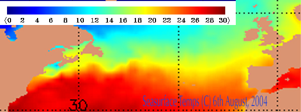
In the case of a transitioning system we need several meteorological parameters to be in position for redevelopment to take place. The latitude of the dieing system although important is not the only governing factor, as is seen from the image of storm tracks during the 1990 (data from NHC) the tracks and locations of transitions are widely spaced.
|
Tracks of all extra-tropic transitioning Atlantic tropical storms from the 1990s. The location of transition for each storm, as determined by NHC, is marked with a dot.
|
The longest-lived storms prior to recurvature (in their ‘‘tropical phase’’) are the most likely to survive recurvature and the transitioning process and, as a consequence, are more likely to reintensify at high latitudes (HE2001).
In addition to latitude and SST, the broadscale features are important. A significant trough in the upstream of the major hurricane, will eventually introduce a thermal gradient across a cyclone that is initially devoid of significant horizontal thermal gradients. This sudden increase in thermal gradient across the tropical cyclone (and the associated wind shear) is often the first sign of the loss of tropical characteristics and the start of extratropical transition. This is further supported by the wind asymmetries documented in such transitioning systems (e.g.,DiMego and Bosart 1982a,b; Thorncroft and Jones2000).”
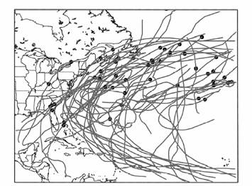
The interior thermal structure of this system is barotropic with little or no asymmetry in temperature gradient across the system. The diagram below shows a cross section of a tropical cyclone which is a none frontal, purely convective system with a symmetrical horizontal temperature profile. The configuration of the system is said to be "symmetrical"
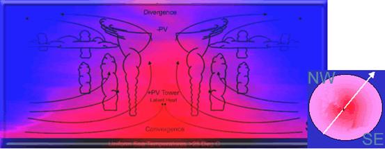
As transition takes place the system gradually changes to a cold core asymmetrical and develops frontal aspects.
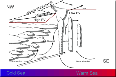 |
The frontal development can be seen of satellite imagery. The central eye of the hurricane becomes obscured as a cloud shield is moved across the eye obscuring it from view.
Click on Thumbnail to view MSG imagery for 4th and 5th August 2004 |
|---|

This phase change can be best represented graphically.
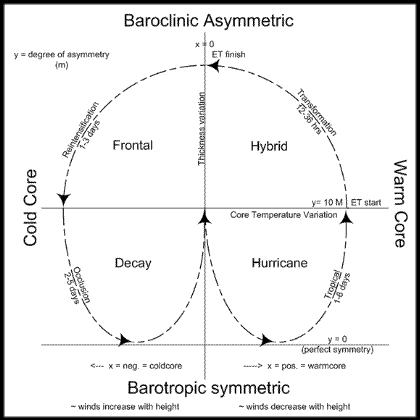
This phase diagram can be used to explain the processes of change that occur in the tropical, transformation, re-intensification and occlusion phases.
Once the hurricane has migrated away from the region of warm, uniform sea temperatures over which it originated towards much cooler sea’s the convective development and release of latent heat, from which the hurricane gains its energy, begins to decrease and the system initially decays.
The degree of symmetry is calculated as the thickness variation measured across the storm perpendicular to track, with the storm width fixed at a value of 500 km, a typical maximum value.
A thickness value of 0 m theoretically denotes perfect symmetry, with anything higher than this techinically defining increasing levels of asymmetry. However, a value of 10m has been found to best represent the practical onset of transformation because it allows for analysis, model and tracking errors.
To balance the hydrostatic equation, warm core systems have winds that decrease with height and cold core systems winds that increase with height. The relative core temperature is measured using the variation in thermal winds in the lower troposphere between 900-600 hPa. To gauge the depth of the core structure the process can be repeated between 600-300 hPa and a comparison made between the two values.
The Tropical Phase finishes and the Transformation Phase commences when the hurricane becomes asymmetric. The Transformation Phase finishes when the ex-hurricane becomes cold core; during the Transformation phase the system is deemed to be hybrid, possessing as it does both tropical and extra-tropical characteristics.
If winds decrease with height in the lower tropopause but not in the higher trop. the hurricane is shallow warm core; this is typical of hurricanes that develop in the high tropics where they form over lower sea temperatures and over a reduced timescale. If winds decrease with height throughout the trop the system is deep warm core and the hurricane is likely to have originated in the deep tropics; as a result, it will have had more time to develop, will have done so over areas of higher sea temperatures, and is likely to possess a more robust structure.
Depth of structure has a fundamental impact upon the transition process because deep cores can maintain their structural integrity longer than shallow cores and hence have a longer window of opportunity to move into favourable development areas during the transition process.