Table of Contents
Relative streams
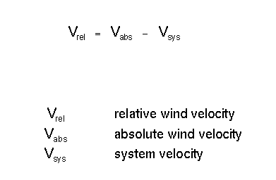
Relative streams on isentropic surfaces have gained more and more importance following the introduction of the concept of conveyor belts. However, until now actual work with relative streams mostly is restricted to research work and is not yet common in operational weather forecasting. Relative streams are streams computed on isentropic surfaces where the potential temperature and/or the equivalent potential temperature is constant relative to a system velocity. This system velocity is subtracted from the absolute velocity:
The determination of the system velocity is one of the critical steps in the computation; it can be derived from the propagation of cloud systems accompanying a weather system. For instance the propagation of the frontal cloud band can be used for the system front and upper level trough.
The subtraction of the system velocity means that an observer would move with the system and that all the air streams and their changes occur relative to this system.
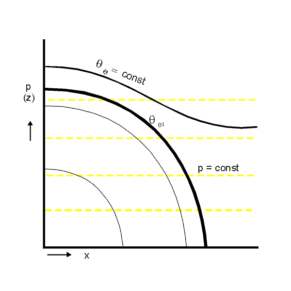
The next schematics explain the connection between presentations on isobaric and isentropic surfaces.
There are two main advantages for an analysis of relative streams:
- The different air masses involved in a weather system are quasi-visualized through the relative streams which transport them; therefore sharp cloud boundaries and other cloud structures can be easily explained.
- An isentropic surface is a surface of constant potential (or equivalent potential) temperature, which means that air particles on such a surface do not undergo any heat exchange and consequently stay and move on this surface. Therefore rising and sinking can directly be seen on an isentropic surface by noting the isobars which are crossed by the streamlines.
As already mentioned, the conveyor belt theory has been derived from such an approach. In the schematics above the typical conveyor belts associated with a Cold Front situation are marked. There is a Warm Conveyor Belt from the south-east bending to the north-east which transports warm and humid air and rises at the frontal surface (in the schematics from 700 to 500 hPa) and which is responsible for the development of the frontal cloudiness. A second main conveyor belt is called dry intrusion which is the relative stream from north-west bending to north-east which transports cold dry air and sinks till it reaches the highest level of the frontal surface (in the schematics from higher than 400 down to 500 hPa). At the boundary between both conveyor belts very often a sharp anticyclonically curved cloud boundary can be observed which is a consequence of the shape of the conveyor belts transporting different air masses; frontal lines mostly show a distinct cyclonic curvature, and at this point such a cloud shape cannot be explained so easily with conventional tools and ideas.
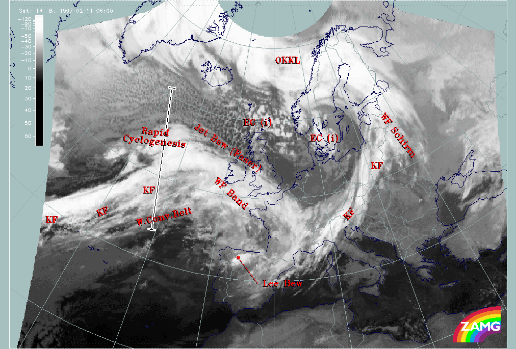
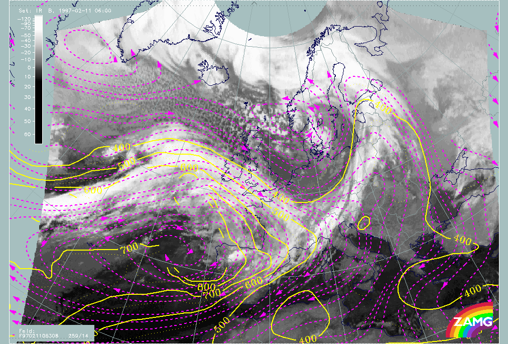
Warm Conveyor Belts and their associated cloudiness are not only involved directly in the frontal systems but appear frequently in the region of high fibrous cloudiness in front of cold fronts in the warm sector. The case study of 11 February 1997/06.00 UTC contains a good example in front of the Atlantic front. Also the conceptual model of the Rapid Cyclogenesis shows some distinct features in the relative streams. Both cloud systems can be used to demonstrate the use and interpretation of relative streams.
|
11 February 1997/06.00 UTC - Meteosat IR image; SatRep overlay: names of conceptual models, position of vertical cross section indicated
|
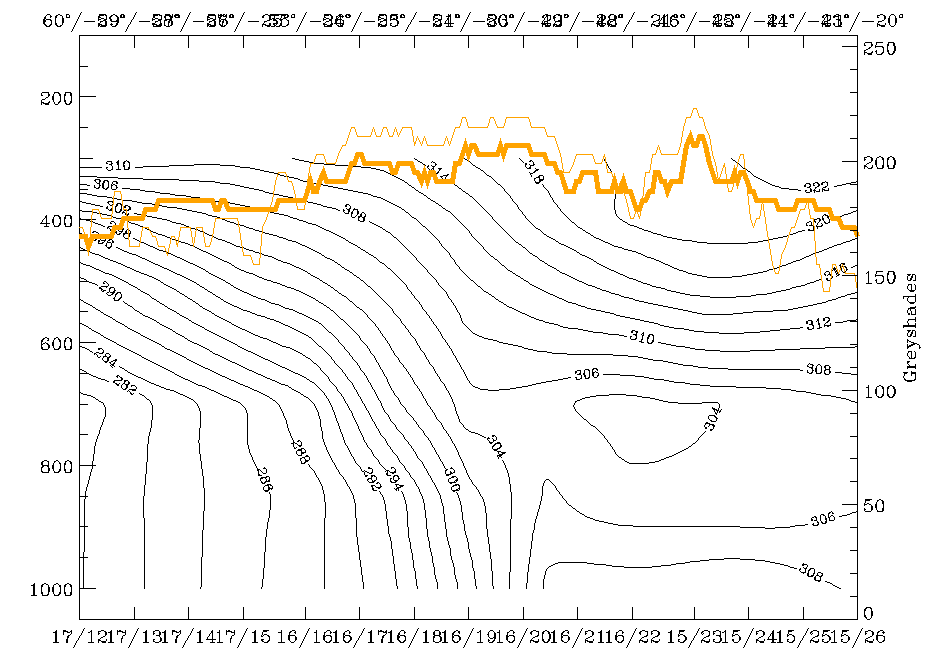
11 February 1997/06.00 UTC - Vertical cross section; black: isentropes (ThetaE), orange thin: IR pixel values, orange thick: WV pixel values
|
|
|
|
|
|
11 February 1997/06.00 UTC - Meteosat IR image; magenta: relative streams 308K - system velocity 259° 14m/s, yellow: isobars
|
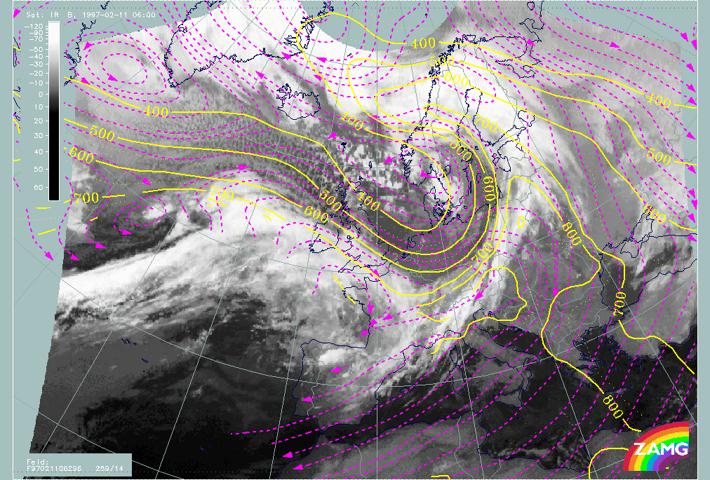
11 February 1997/06.00 UTC - Meteosat IR image; magenta: relative streams 308K - system velocity 259° 14m/s, yellow: isobars
|
Relative streams at the upper level of 308K (left image) should be indicative of the fibrous cloud system diagnosed as warm conveyor belt ("W.Conv.Belt") and indeed the magenta lines show a relative stream from east (from Spain to about 35W) bending there to the north-east up to about 10W where it bends to the south again. This north-eastward oriented part of the stream in front of the cold front and the southward oriented part behind the Warm Front is accompanied by cloudiness which shows fibrous structure. The orientation of the fibres and other cloud parts coincides quite well with the relative streams there. In the westward oriented branch no distinct vertical motion can be recognized. The eastward oriented branch rises at first slightly. The more it approaches the frontal zone the rising of this relative stream gets even more pronounced. In the Bay of Biscay rising motion from 800 - 700 up to 650 - 550 hPa (yellow lines) occurs.
Relative streams within and north of the frontal cloud band clearly show a different origin from behind the Cold Front, therefore different air masses are approaching. Especially in the area of the Rapid Cyclogenesis a relative stream from north-west is involved in these height levels.
The low isentropic surface of 296K (right image) is representative of the situation in the area of the Rapid Cyclogenesis. It is a surface which is in the centre of the broad frontal zone and reaches the earth surface at grid point 16/18 which is approximately 52N/26W. There are two different relative streams involved: the one from the south rising sharply from the surface up to 550 hPa and bending to the east there; the second shows up as a small cyclonic circulation to the west in the area of the cloud spiral. Both represent a typical configuration for this conceptual model.
Vertical Cross Sections
Until now the parameters discussed have been computed and analysed on isobaric surfaces, an approach which is a very common in an operational forecasting environment. Nevertheless, the disadvantage of such a working concept is the difficulty in combining the evaluation results of single levels vertically. However, this view into the vertical distribution of different parameters allows a new understanding of the processes taking place in the troposphere.
Cross sections are a very valuable tool. Parameters which are of special interest for such a presentation are potential temperature and equivalent potential temperature as well as humidity, which together can be used, for instance, for stability or instability computations. However, parameters discussed earlier such as temperature advection, vorticity and vorticity advection, divergence and vertical motion can reveal interesting processes in the vertical. Most of the parameters can be computed from numerical model output, some of them such as stability or Richardson number need the higher vertical resolution of radiosonde data.
Equivalent potential temperature is especially useful for revealing frontal zones. They consist of zones of high gradients inclined downward from high levels, for instance 300 hPa to the ground (in the case of a surface front). Cold and Warm Fronts as well as Occlusions and conditionally unstable areas can also be differentiated in this way.
The following examples from the demonstration case study are a selection of parameters showing some typical features of a cross section through the Cold Front in Central Europe (satellite image with superimposed cross section line below).
|
11 February 1997/06.00 UTC - Meteosat IR image; SatRep overlay: names of conceptual models, position of vertical cross section indicated
|

|
|
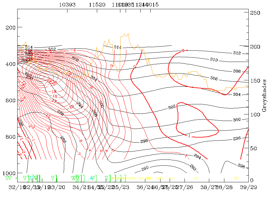
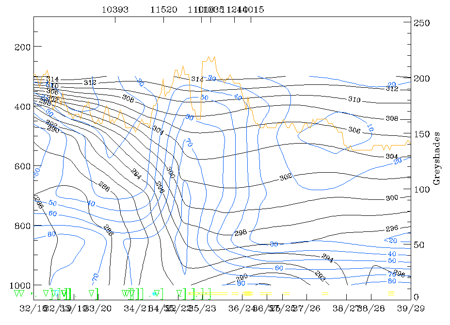
11 February 1997/06.00 UTC - Vertical cross section; black: isentropes (ThetaE), red thin: temperature advection - CA, red thick: temperature advection - WA, orange thin: IR pixel values, orange thick: WV pixel values
|
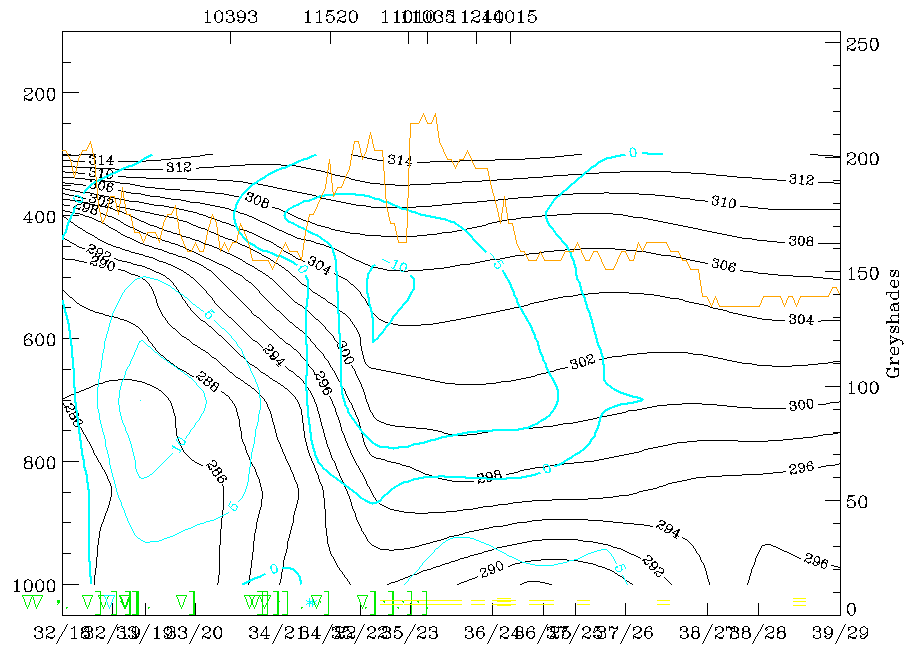
11 February 1997/06.00 UTC - Vertical cross section; black: isentropes (ThetaE), blue: relative humididty, orange thin: IR pixel values, orange thick: WV pixel values
|
|
|
Both figures, immediately above, show, with black lines, a broad crowding zone inclined downward from heights between 300 and 400 hPa above grid point 32/18 (which is close to Copenhagen) to the surface with a surface front close to grid point 35/22 which is between the station Prague (11520) and Vienna (11035). But in agreement with the double structure in the cloud band there is also a double structure in the frontal zone indicating a second surface front north of Prague (11520) between the grid points 34/21 and 34/22.
Although the maximum of cold advection (CA; thin red lines in the left figure) appears within the crowding zone and closer to its lower boundary, the whole frontal surface is, in fact, associated with CA. CA can also be found in front of the frontal zone which, in classical cases, should be an area of maximal warm advection (WA). WA (thick red lines) can, in fact, be found only south of the station Graz (11240).
The humidity field (right image top, blue lines) shows a high humidity zone which is forward inclined from the station Prague (11520, between grid points 34/21 and 35/22) close to the ground up to about 400 hPa south of Vienna (11035, between grid points 35/23 and 36/24). This is typical of a Kata Cold Front with cloudiness and precipitation in front of the frontline. The weather symbols on the base line below 1000 hPa show some slight actual rain falling near to grid point 35/23 which, when compared to the humidity field (right image), is associated with a very humid layer between 800 and 650 hPa on top of the frontal surface. In the cold air below the frontal surface a lot of showers appear.
The orange line in the above cross section represents the IR pixel values. The highest values representing the cloudiness of the Cold Front can be found between the station Prague (11520) and the grid point 36/24 which corresponds to the zone of high humidity.
|
11 February 1997/06.00 UTC - Vertical cross section; black: isentropes (ThetaE), cyan thick: vertical motion (omega) - upward motion, cyan thin: vertical motion (omega) - downward motion, orange thin: IR pixel values, orange thick: WV pixel values
|
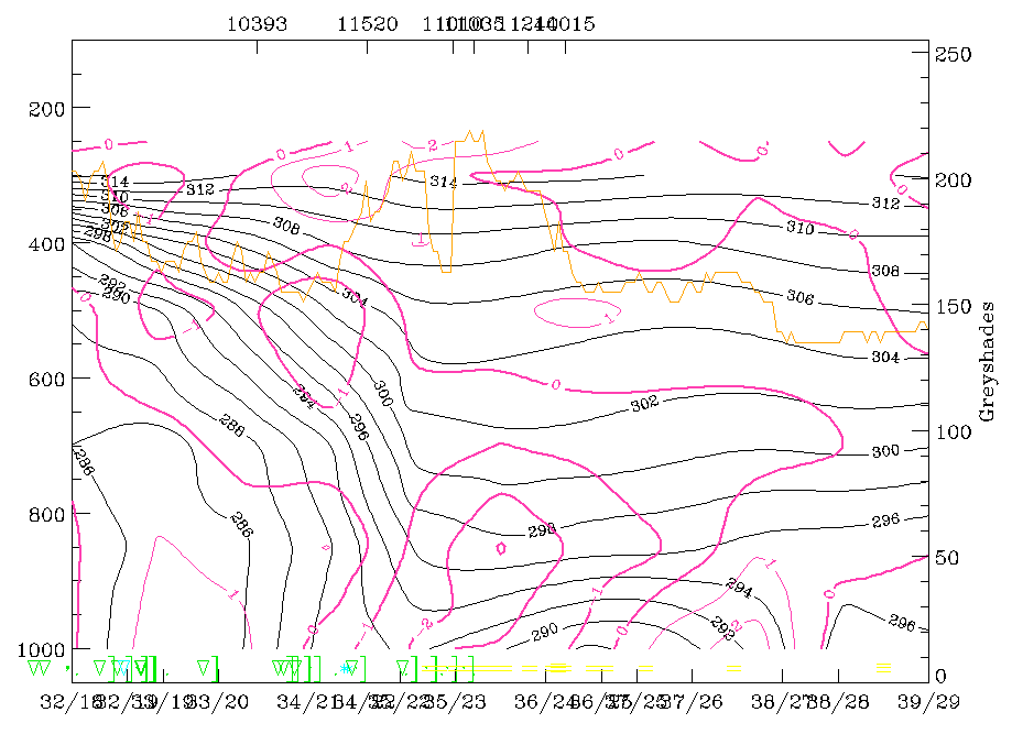
11 February 1997/06.00 UTC - Vertical cross section; black: isentropes (ThetaE), magenta thin: divergence, magenta thick: convergence, orange thin: IR pixel values, orange thick: WV pixel values
|
|
|
|
|
|
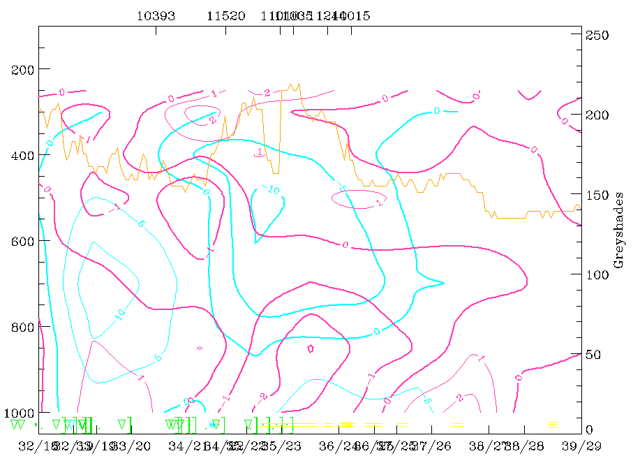
11 February 1997/06.00 UTC - Vertical cross section; black: isentropes (ThetaE), magenta thin: divergence, magenta thick: convergence, cyan thick: vertical motion (omega) - upward motion, cyan thin: vertical motion (omega) - downward motion, orange thin: IR pixel values, orange thick: WV pixel values
|
The combination of isentropes and vertical motion (omega) shows a backbent zone of maximum upward motion in front and on top of the frontal zone as well as downward motion within and below the frontal zone. This is a classical distribution which helps to explain two effects:
- The existence of cloudiness in front of the surface frontline especially in the case of a Kata Cold Front;
- The upgliding of warmer air on top of the frontal surface and the sinking of the cold air below the frontal surface.
It is also very interesting to note the relevant contributions to upward motion as already discussed in the case of isobaric surfaces in the previous chapter. The left figure bottom shows the combination of divergence and omega. The thick magenta lines represent convergence and there is a backward inclined zone from the surface with a maximum between grid points 35/23 and 36/24 up to 400 - 300 hPa with another maximum between the stations Prague (11520) and Lindenberg (10393). This zone of convergence coincides with the frontal zone represented in the isentropes and reveals the basic frontal conditions. The zone of upward motion on top of the convergence zone supports the basic idea of a circulation cell described in chapter Divergence.
These have been a few selected examples to show the potential use of vertical cross sections; in the manual the typical structure of the relevant parameters in vertical cross sections is described for every conceptual model. In the case studies vertical cross sections are also widely used.