Case Study


Prefrontal Convergence
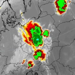
On July 30th 2005 a prefrontal convergence line formed at the leading edge of a cold front. The long convergence line stretched from Italy over Austria into Poland and the Baltic States. Based on satellite imagery a sequence of thunderstorms could be observed. Moreover it should be noted that this form of prefrontal convergence is clearly linked to the diurnal cycle. As night sets in, most of the cells dissolve.
Since convection is a rather small scale phenomenon, it can be beneficial to address high resolution limited area models such as ALADIN-AUSTRIA. The comprehensive analysis of ALADIN-AUSTRIA revealed converging motions at 925 hPa and the divergence (e.g. outflow of air near the cloud top) at 700 hPa. In regard to the stability analysis the nowcasting tool GII (Global Instability Index) provided by EUMETSAT proved to be useful.
Filed under Keywords:
Squall Line, Stability Indices, Convection