Webcast

HSAF precipitation products
The Satellite Application Facility for supporting operational hydrology and water management (H-SAF), established in 2005 as part of the
EUMETSAT SAF network, is designed to provide the user community with new satellite-derived products from existing and future satellites with
sufficient time and space resolution to satisfy the needs of operational hydrology. Three hydrological variables are considered(soil moisture,
snow at the ground and precipitation) and a number of related parameters are made available to the user community, with a quantitative description
of their accuracy.
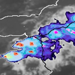
Precipitation products are derived from algorithms based on different satellite data (active and passive microwave, visible/infra-red) and
approaches (artificial neural network, Bayesian statistics, pattern recognition) to provide the most advanced set of precipitation product over
Europe, and, in the next future, over Africa. The use of H-SAF precipitation products to study the severe meteorological events occurred in Italy
in the autumn 2014 showed their potential as additional tools in monitoring heavy rainfall, especially in cases when conventional, ground-based
instruments are not able to fully describe the precipitation pattern and intensity.
Filed under Keywords:
HSAF, precipitation, products, active microwave, passive microwave, hydrology

