Webcast

Above anvil convective plumes atop major European hailstorms in 2018
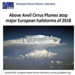
Above anvil cirrus plumes (AACPs) have been established in the scientific literature since 1980s. Recent improvements in the temporal and spatial resolution of the satellite data brought back attention to their potential use as an indicator of severity of convective storms. In 2018, we have identified 26 days, where damaging hail reaching at least 5 cm, causing significant economic or societal impact was reported to the European Severe Weather Database. For the selected hailstorm days, where rapid-scan imagery with 5-minute temporal resolution was available, we identified 29 very large (>= 5 cm) hail producing storms. 25 of these hailstorms did show an AACP, but only 12 of these plume producing storms could be clearly identified using the visible imagery. The range of lead time of the AACP appearance to the first hail report was very large and in about half of the cases, the plume occurred only during or after the time of the first large hail report. Due to the limited number of cases, the main purpose of the presentation is, rather than drawing conclusions, to open a discussion on the operational usability of AACPs in warnings for convective storms.

