Introduction
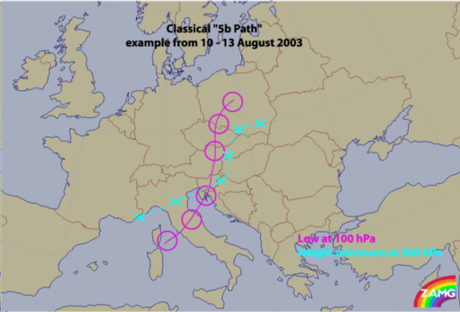
In August 2002 two Mediterranean low pressure systems developed, taking a so-called 5b path. Such occurrences are rather unusual in summer as was the very rapid repetition rate of two events within about 8 days. The first event happened between 06 and 08 August, the second between 10 and 13 August.
|
|
|
As can be seen in the schematic above - which shows the relative positions of low centres - a 5b cyclone develops in the Mediterranean over the Gulf of Genoa and moves northward across N. Italy, Slovenia, E. Austria and Hungary and further across the Czech Republic to Poland. From there the classical 5b cyclone turns to a more easterly direction.
5b cyclones are very weather intensive phenomena as air masses are involved which contain high amounts of humidity. During their path northward the cloud system becomes occluded and as a consequence of the inherent circulation, significant Stau effects happen at the northern region of the Alps as well as over the Slovakian and Czech mountains. Therefore, countries which usually suffer from such bad weather are Austria, Slovakia, Czech Republic, some parts of Germany, as well as parts of Hungary and Poland.
When such a weather situation is associated to extremely high amounts of humidity, floods can occur and as the major rivers like the Danube and the Elbe carry their flood water downstream, countries like Hungary and Germany also become affected. But before these big rivers come into play, flooding smaller rivers within single countries can already cause serious damage.
This was the case in Austria where, during the first phase, damage was caused by smaller rivers in Salzburg and Lower Austria (for instance the Kamp valley). In parallel, and during the same phase, there were high water levels in the Danube in Bavaria and consequently in the second flood-event the flood water came from both, the Danube and again the smaller rivers.
From a meteorological point of view the model forecasts of these events are of utmost importance. For Austria the global model of ECMWF and the Aladin and Aladin-Vienna Local Area Models (LAM) were used. Generally speaking, both models (with different strengths and weaknesses) had produced very good forecasts of amounts and the locations of precipitation.
The reasons for the major damage and the critical situation with respect to human security cannot be blamed upon lack of warnings from weather forecasters. These catastrophic flood event once more showed problems arising from other sources; for instance:
- Building new houses within areas which have a high probability of flood
- The timely use of precipitation forecasts in hydrological models
- Inappropriate plans for protecting property and evacuating persons in catastrophic situations, taking into account all the necessary psychological background
From the viewpoint of the Conceptual Model Approach a detailed investigation of the various models involved and their evolution is of high interest and could lead to impproved modelling of these situations and the earlier issue of warnings.
