29 July 1997 - Diagnosis For 18.00 UTC With Help Of Vertical Cross Sections
|
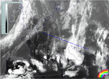
29 July 1997/18.00 UTC - Meteosat IR image; position of vertical cross section indicated
|
|
|
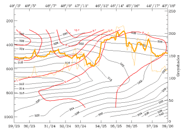
29 July 1997/18.00 UTC - Vertical cross section; black: isentropes (ThetaE), red thin: temperature advection - CA, red thick:
temperature advection - WA, orange thin: IR pixel values, orange thick: WV pixel values
|
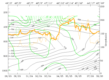
29 July 1997/18.00 UTC - Vertical cross section; black: isentropes (ThetaE), green thick: vorticity advection - PVA, green thin:
vorticity advection - NVA, orange thin: IR pixel values, orange thick: WV pixel values
|
|
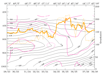
29 July 1997/18.00 UTC - Vertical cross section; black: isentropes (ThetaE), magenta thin: divergence, magenta thick: convergence,
orange thin: IR pixel values, orange thick: WV pixel values
|
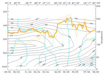
29 July 1997/18.00 UTC - Vertical cross section; cyan thick: vertical motion (omega) - upward motion, cyan thin: vertical motion
(omega) - downward motion, magenta thin: divergence, magenta thick: convergence, orange thin: IR pixel values, orange thick: WV pixel
values pixel values
|
In the vertical cross section for 18.00 UTC there is now only one peak area for IR and WV where the two cloud systems have merged (gridpoints 34/25 - 35/25) (compare Diagnosis for 06.00 UTC with help of vertical cross sections and Diagnosis for 12.00 UTC with help of vertical cross sections ). Distribution of isentropes still shows an intensive unstable air mass from the surface up to at least 600 hPa but the vertical distribution of temperature advection (top left image)is less pronounced now. PVA (top right image) is clearly related to the cloud system now, indicating the approach and mergence of the upper level feature which has taken place during the last 12 hours. Numerous thunderstorms appear in the area of PVA.
The vertical distribution of convergence (bottom left image) and vertical motion (bottom right image), which were very important qualities in the discussion till now, confirm (as does temperature advection) that a change in the state of the troposphere is taking place, although there are still many thunderstorms. Convergence has a more diffuse appearance in the cloud area now and a transition to sinking motion has taken place.
In the following chapter dealing with the thunderstorm developments the breakdown of the convective situation from this time on can be observed.
