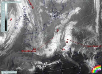
29 July 1997 - Overview Of Satellite Features And Conceptual Models
|
29 July 1997/06.00 UTC - Meteosat IR image; SatRep overlay: names of conceptual models
|
|
The image above shows the initial situation on 29 July at 06.00 UTC: the following cloud systems can be diagnosed in the Central and Western European areas:
- A band-like cloud system extending from the west Alps across Switzerland to south Germany (compare Diagnosis of the western cloud feature - Conceptual model "Front Intensification by Jet Crossing" ); the part over Germany can be identified as an area of cloud intensification in the left exit region of a jet streak (in short form "Jet Intensification") (compare Conceptual Models: Front Intensification by Jet Crossing )
- A band-like cloud system extending from the north Adriatic Sea across Slovenia and east Austria to the Czech Republic and south Poland (compare Diagnosis of the eastern cloud feature - Conceptual models "Convergence Cloudiness" and "Cumulonimbus (Cb) and Mesoscale Convective System (MCS)" ); it can be identified as "Convergence Cloudiness" (compare Conceptual Models: Convergence Cloudiness ) with two areas of thunderstorms (Cb) embedded
- A Cold Front "CF" (compare Conceptual Models: Cold Front ) over the Atlantic approaching the British Isles
- Fibrous cloudiness extending from the North Sea into France; this feature is indicative of cloudiness on the anticyclonic side of the jet axis and supports the initial diagnosis (compare Conceptual Models: Jet Cloudiness (Fibre) )
