Table of Contents
- I. Introduction and Conceptual Models for 09 April 1996/06.00 UTC
- II. Conceptual Models - Forecast for 09 April 1996/12.00 UTC and 18.00 UTC
- III. "Special Investigation": Diagnosis of a Mesoscale Cloud Band
- IV. "Special Investigation": Rapid Cyclogenesis
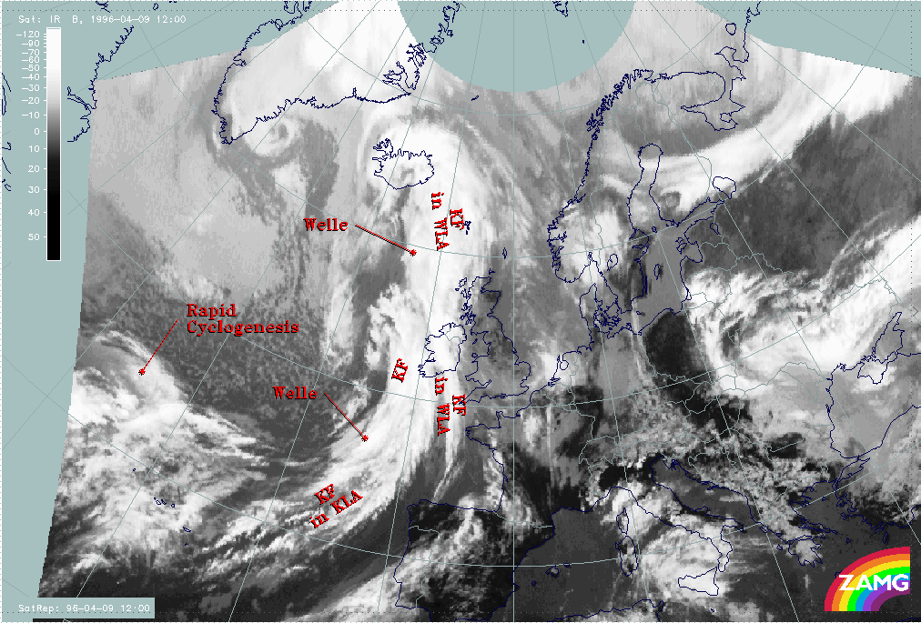
Introduction and short case description
|
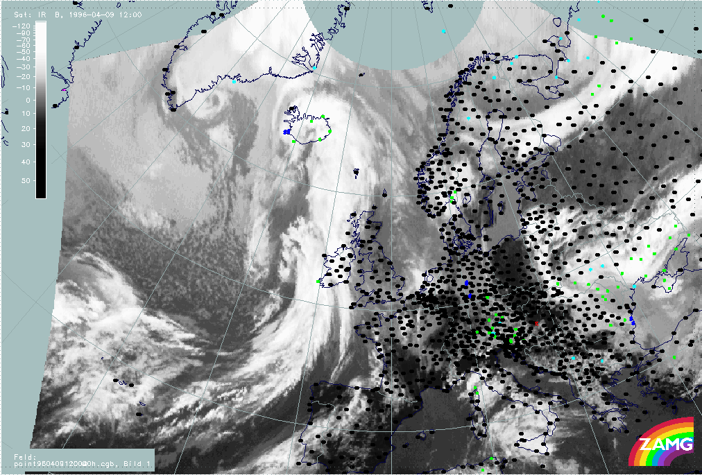
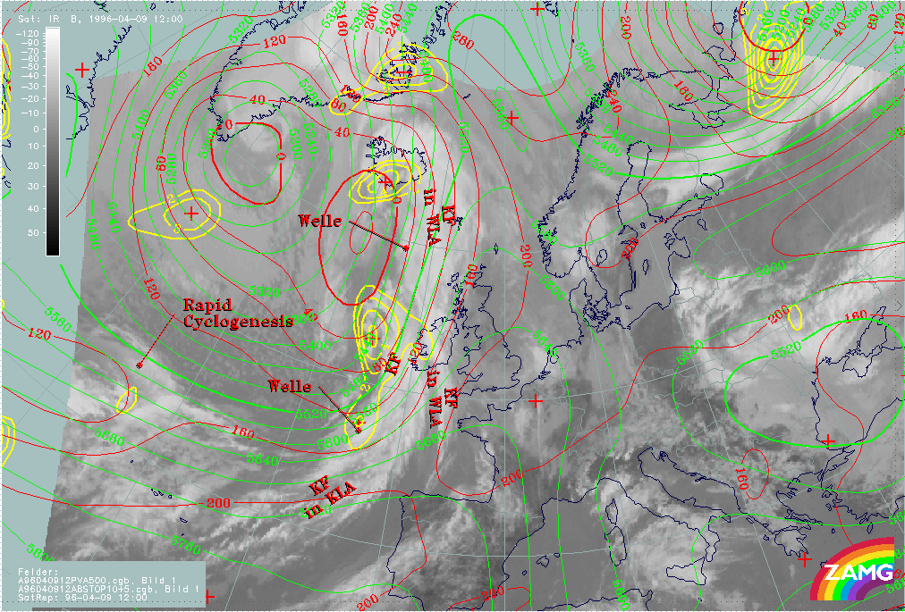
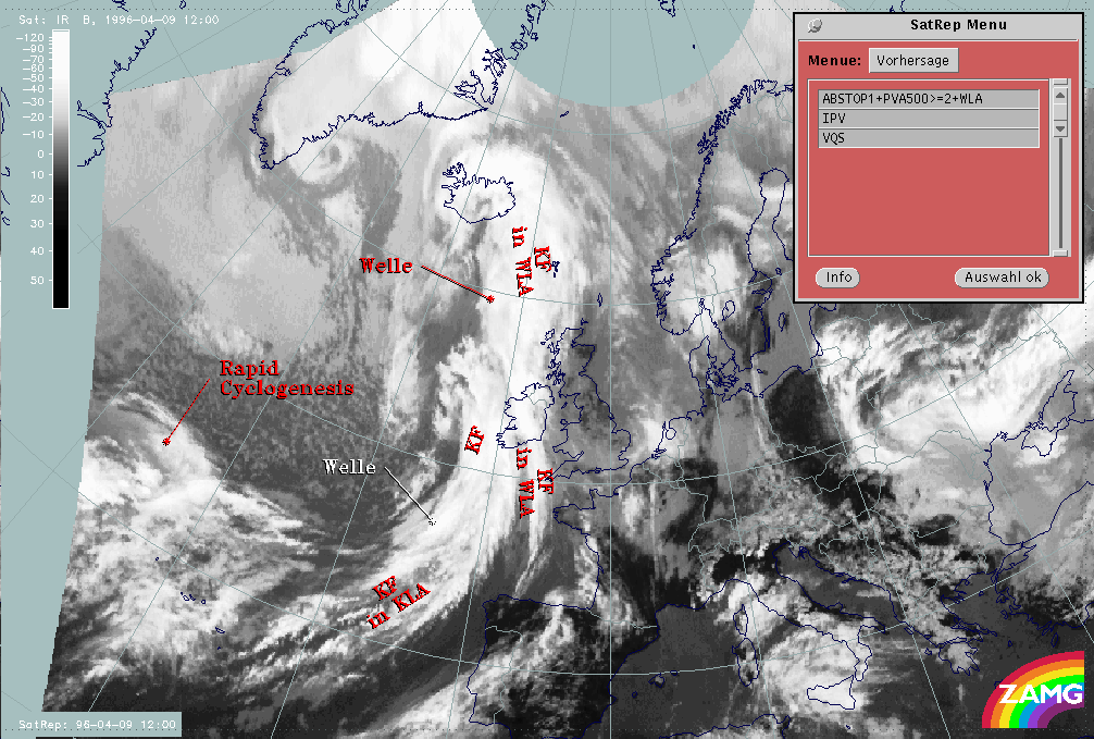
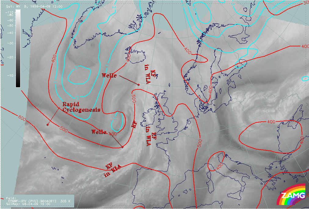
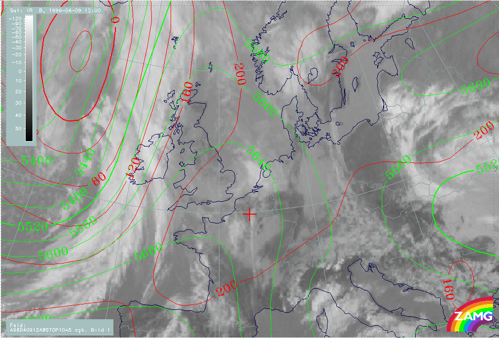
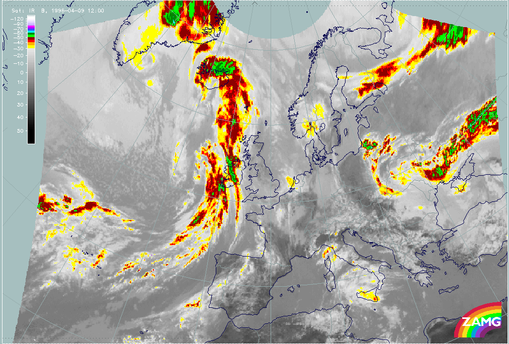
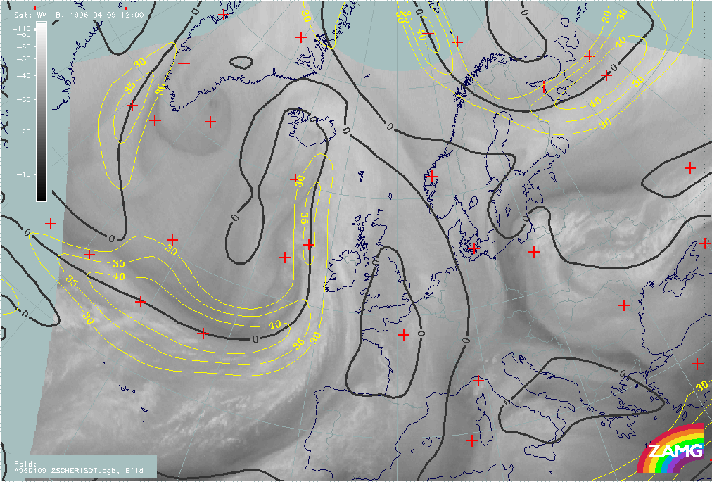
09 April 1996/12.00 UTC - Meteosat IR image; weather events (green: rain and showers, blue: drizzle, cyan: snow, purple: freezing rain,
red: thunderstorm with precipitation, orange: hail, black: no actual precipitation or thunderstorm with precipitation)
|
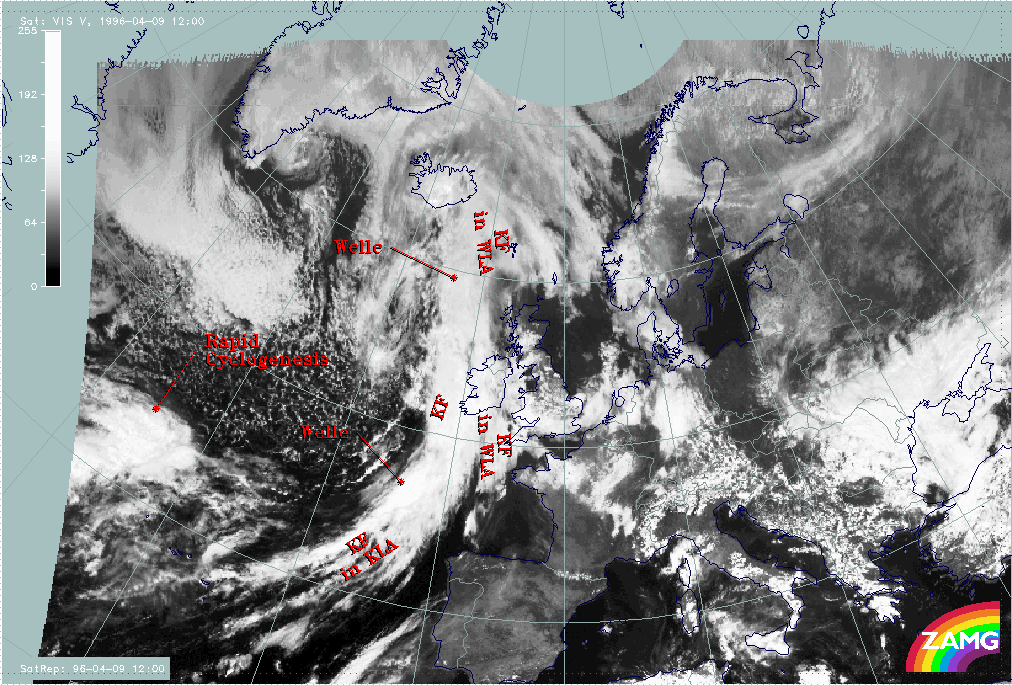
09 April 1996/12.00 UTC - Meteosat IR image; SatRep overlay: names of conceptual models
|
|
|
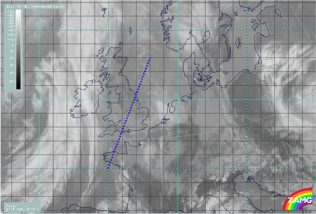
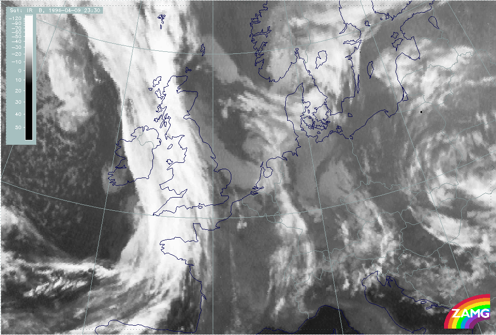
The satellite image contains the cloud band of a Cold Front in Warm Advection stretching from the Bay of Biscay across Ireland to east Iceland. Immediately behind the southern part of this cold front a second cloud band of a Cold Front can be observed above the Atlantic beginning east of the Azores to approximately 57N/16W. Due to the different distribution of the temperature advection this Cold Front can be divided into two parts:
- A so-called classical Cold Front situated at the northern or downstream side of the Wave (see next paragraph);
- A Cold Front in Cold Advection (CA) at the southern or upstream side.
Both Cold Fronts are accompanied by a mesoscale substructure in the form of a Wave. In the case of the Cold Front in Warm Advection the wave can be found above the Atlantic north-west of Ireland at approximately 59N/13W. In the case of the classical Cold Front it is situated south-west of Ireland at about 52N/12W.
Above the Atlantic north-west of the Azores at approximately 44N/35W the satellite image shows the cloud head of a Rapid Cyclogenesis at approximately 44N/37W.
Further, a band of mostly deep cloudiness (compare IR and VIS images above) extends from south England across the coast of the Netherlands to the North Sea west of Denmark at approximately 56N/08E. This cloud band is not analyzed within SatRep and will be described in more detail in the third part of this case study - "Special Investigation": Diagnosis of a Mesoscale Cloud Band.
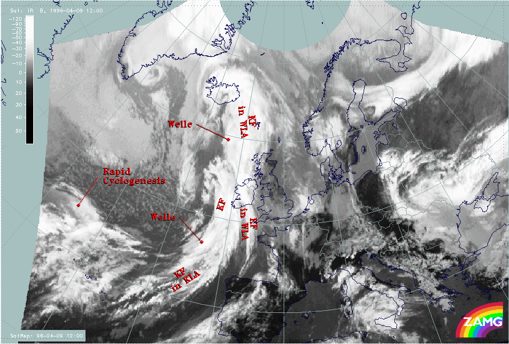
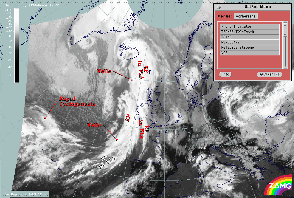
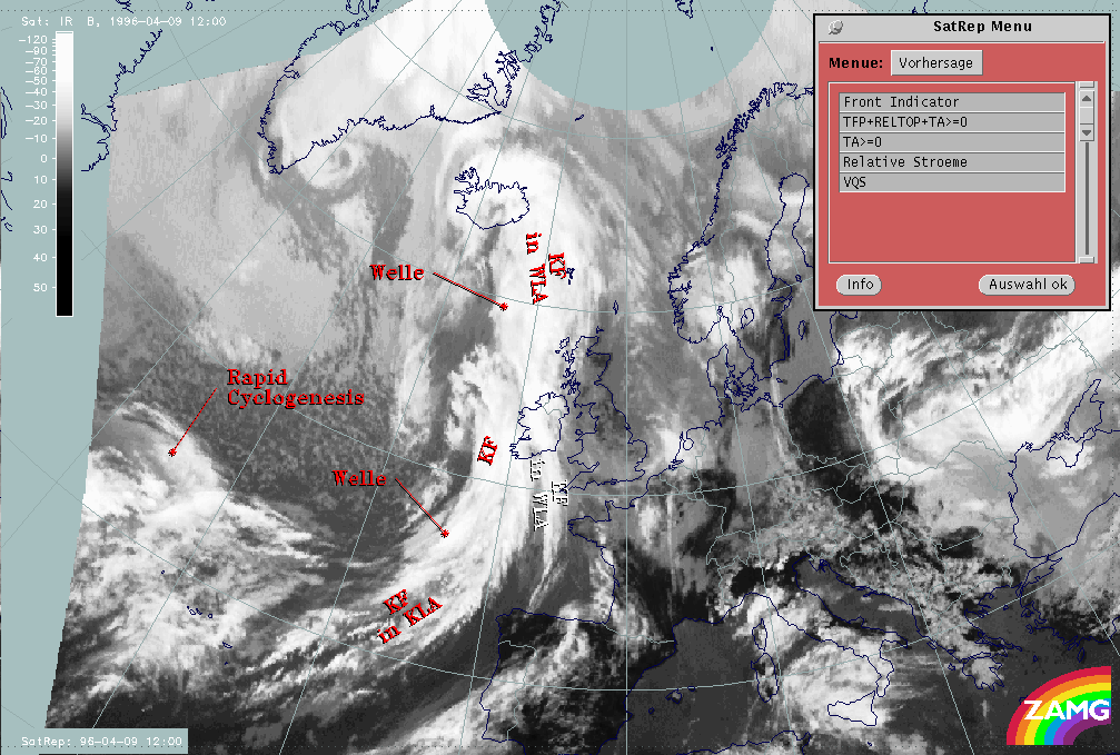
The next image contains the superimposed names of the conceptual models diagnosed within the first level of SatRep:
- KF: Cold Front
- KF IN WLA: Cold Front in Warm Advection
- KF IN KLA: Cold Front in Cold Advection
- WELLE: Wave
- RAPID CYCLOGENESIS: Rapid Cyclogenesis
|
09 April 1996/12.00 UTC - Meteosat IR image; SatRep overlay: names of conceptual models
|
|
|
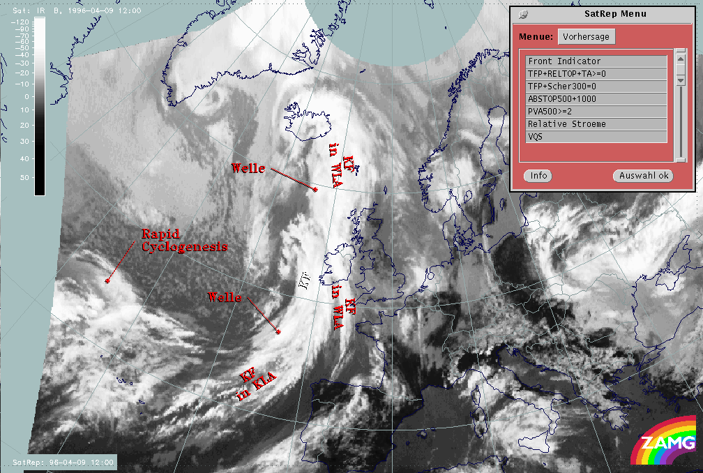
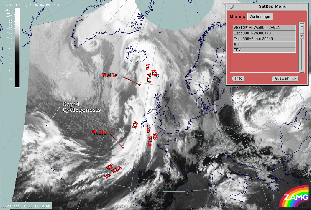
The second level of SatRep shows more detailed information about the above-mentioned conceptual models and will be described in the chapters below. The third level of SatRep, the forecast, can be found within the second part of this case study - Conceptual Models - Forecast for 09 April 1996/12.00 UTC and 18.00 UTC.
09 - 10 April 1996 - Cold Front
|
09 April 1996/12.00 UTC - Meteosat IR image; SatRep overlay: names of conceptual models, SatRep menu: key parameters for Cold Front
|
|
|
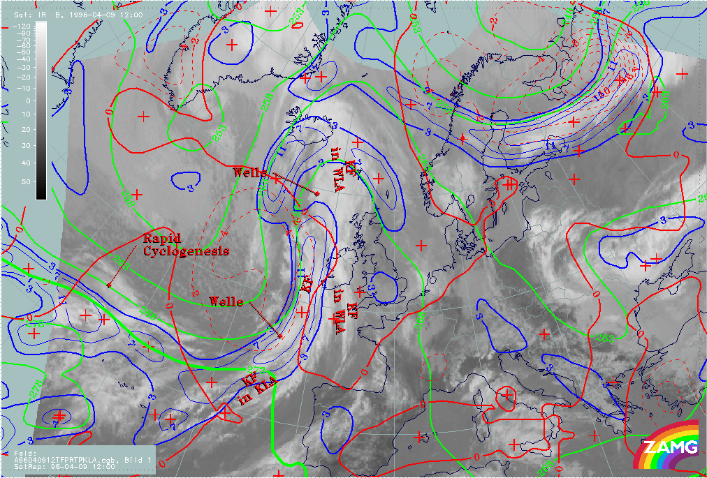
For the diagnosis of the Cold Front a couple of key parameters with special thresholds as well as useful combinations of key parameters have been developed (for more information compare also the manual, Conceptual Models: Cold Front ).
| Front Indicator: | The front indicator indicates the maximum values of the thermal front parameter (TFP) 500/850 hPa (*10-1Km-1) which is an indication for the surface front |
|---|---|
| TFP + rel.Top + TA>=0: | This combination contains the thermal front parameter (TFP) 500/850 hPa greater than 3 units, the equivalent thickness (rel.Top) 500/850 hPa (K) and warm advection 500/1000 hPa (TA>=0) (K 12h-1); this parameter combination contains the information about the thermal situation in the area of the Cold Front |
| TFP + Scher300=0: | This combination contains the TFP and the zero line of shear vorticity at 300 hPa (Scher300=0) and is indicative of the relation between front and jet stream; with the help of this combination it is also possible to identify whether the Cold Front is from the Ana or the Kata Cold Front type |
| abs.Top500 + abs.Top1000: | This key parameter combination shows the geopotential height at 500 hPa (abs.Top500) (gpm) as well as at 1000 hPa (abs.Top1000) (gpm), both parameters show the pressure distribution within the mid-levels of the troposphere (abs.Top500) and on the surface (abs.Top1000) |
| PVA500>=2: | This field shows areas of positive vorticity advection (PVA) at 500 hPa greater than 2 units (*10-9sec-2); this parameter is an indicator of upward motion and therefore describes possible areas of increased weather events (compare also Conceptual Models: Wave , Conceptual Models: Rapid Cyclogenesis and Conceptual Models: Front Intensification by Jet Crossing ) |
| Relative Stroeme: | The relative streams show the flow of the relative wind field; this point of view gives more detailed information about the different air masses (like for instance their origin or areas with sinking or rising motion) which are involved within the corresponding meteorological system; in contrast to the parameters described above which are analyzed on isobaric surfaces, the relative streams show the situation on isentropic surfaces |
| VQS: | The cross section gives a better understanding of the vertical construction of the different meteorological systems; with this parameter the forecaster can locatecalculated cross sections (VQS) |
The cloud band of the "classical" Cold Front extends over the Atlantic from approximately 49N/12W to approximately 57N/16W. The cloud band of the Cold Front is separated from the southern part of the cloud band (Cold Front in Cold Advection) by a Wave. This mesoscale feature will be described in more detail within the sub-chapter Wave .
|
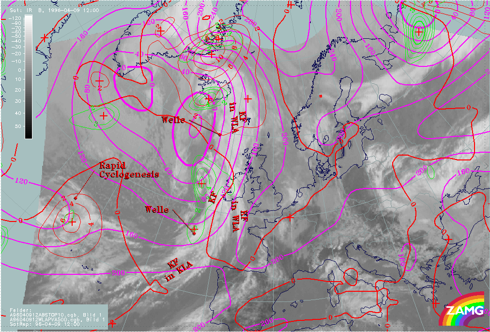
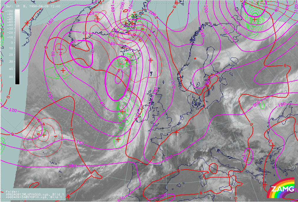
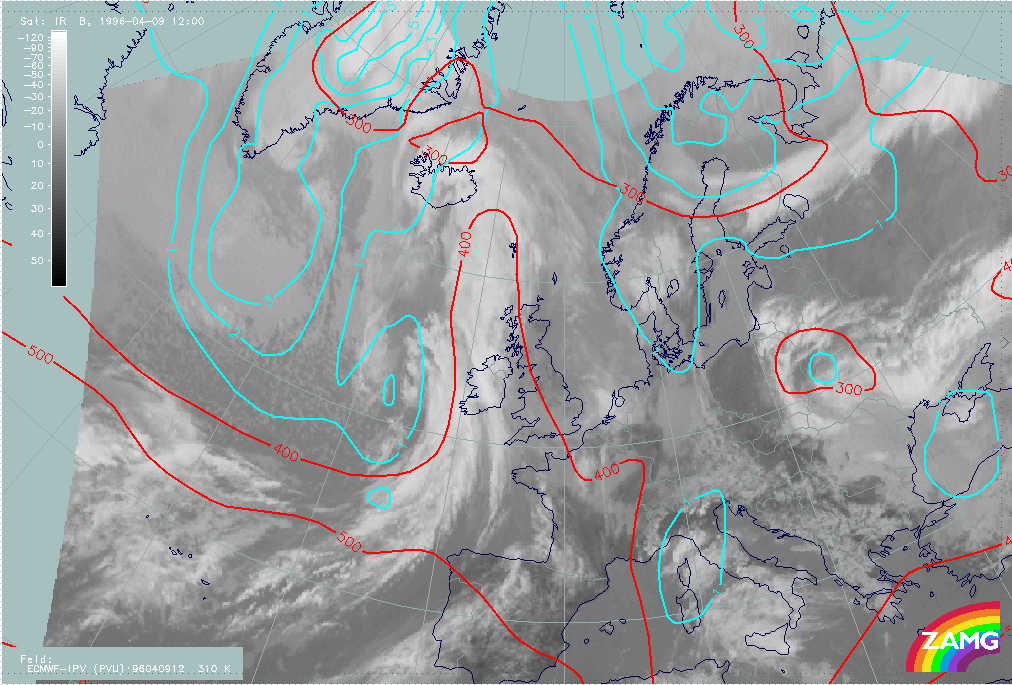
09 April 1996/12.00 UTC - Meteosat IR image; green: height contours 500 hPa, red: height contours 1000 hPa, yellow: positive vorticity
advection (PVA) 500 hPa; SatRep overlay: names of conceptual models
|
|
|
The figure above contains absolute topography height contours at 1000 and 500 hPa. At both heights a well-developed trough can be observed at the rear side of the frontal cloud band. The backward inclination of the trough axis (the axis at 500 hPa is situated upstream of the axis at 1000 hPa) can be easily recognized by the different position of the axis. The absence of a developed surface low is an indication that the Cold Front is in an early stage of development.
The third parameter which is superimposed on the image is the field of PVA at 500 hPa. This shows high values along the rear edge of the frontal cloud band. These pronounced values of PVA are an indication for the deepening of the trough. Areas of PVA maxima, superimposed on the frontal cloudiness, are due to regions with increased upward motion where severe weather events can preferentially occur (thunderstorms and heavy rain showers).
|
09 April 1996/12.00 UTC - Meteosat IR image; thermal front parameter (TFP) 500/850 hPa, green: equivalent thickness 500/850 hPa, red:
temperature advection - WA 1000 hPa; SatRep overlay: names of conceptual models
|
|

|
The second figure contains the superimposed parameter combination of the TFP, the equivalent thickness and the field of warm advection. The crowding zone of the equivalent thickness can be found behind the frontal cloud band. As a consequence of the position of the crowding zone, the TFP shows its maximum values, and therefore the surface cold front, within the rear area of the cloud band. Both features are characteristic of an Ana Cold Front. The third parameter, the temperature advection, shows the zero line within the leading area of the Cold Front. Therefore weak warm advection can be found in front of the Cold Front while more pronounced cold advection can be found within and behind.
The further development of the Cold Front for the next 12 hours can be found within the second part of this case study (compare also the second part of this case study Conceptual Models - Forecast for 09 April 1996/12.00 UTC and 18.00 UTC).
09 - 10 April 1996 - Cold Front In Cold Advection
|
09 April 1996/12.00 UTC - Meteosat IR image; SatRep overlay: names of conceptual models, SatRep menu: key parameters for Cold Front in
Cold Advection
|
|
|
| Front Indicator: | The front indicator indicates the maximum values of the thermal front parameter (TFP) 500/850 hPa (*10-1Km-1) which is an indication for the surface front |
|---|---|
| TFP + rel.Top + TA<=0: | This combination contains the thermal front parameter (TFP) 500/850 hPa greater than 3 units, the equivalent thickness (rel.Top) 500/850 hPa (K) and cold advection 500/1000 hPa (TA<=0) (K 12h-1); this parameter combination contains the information about the thermal situation in the area of the Cold Front |
| TA=<0: | This key parameter shows, as described in the combination above, the thermal situation in the area of the Cold Front |
| PVA500>=2: | This field shows areas of positive vorticity advection (PVA) at 500 hPa greater than 2 units (*10-9 sec-2); this parameter is an indicator of upward motion and therefore describes possible areas of increased weather events (compare also the chapters within the manual Conceptual Models: Wave , Conceptual Models: Rapid Cyclogenesis and Conceptual Models: Front Intensification by Jet Crossing ) |
| Relative Stroeme: | The relative streams show the flow of the relative wind field; this point of view gives more detailed information about the different air masses (like for instance their origin or areas with sinking or rising motion) which are involved in the corresponding meteorological system; in contrast to the parameters described above, which are analyzed on isobaric surfaces, the relative streams show the situation on isentropic surfaces |
| VQS: | The cross section gives a better understanding of the vertical construction of the different meteorological systems; with this parameter the forecaster can locate calculated cross sections (VQS) |
The cloud band of this Cold Front extends from the Atlantic east of the Azores to approximately 47N/13W. The cloud band of the Cold Front in Cold Advection is separated from the cloud band of the classical Cold Front by a Wave. This mesoscale feature will be described in more detail within the sub-chapter Wave .
Like the classical Cold Front (compare sub-chapter Cold Front ) the crowding zone of the equivalent thickness can be found behind the Cold Front cloud band. The TFP has its maximum values, representing the surface Cold Front, within the rear part of the cloud band.
|
09 April 1996/12.00 UTC - Meteosat IR image; thermal front parameter (TFP) 500/850 hPa, green: equivalent thickness 500/850 hPa, red:
temperature advection - CA 1000 hPa
|
|
|
In contrast to the classical Cold Front, described above, the whole frontal cloud band is within cold advection. The distribution of the cold advection is the important parameter, which decides whether frontogenesis or frontolysis takes place (for more information compare also Conceptual Models: Cold Front in Cold Advection ). In the case of this Cold Front it can be observed that weak cold advection can be found in front of as well as behind the frontal cloud band. Because of this distribution there is no significant change in the gradient of temperature advection in front of and behind the frontal cloud band. Due to this missing temperature contrast there will be no further development of this Cold Front and therefore frontolysis will take place.
The further development of the cold front in cold advection for the next 12 hours can be found within the second part of this case study (compare also the second part of this case study Conceptual Models - Forecast for 09 April 1996/12.00 UTC and 18.00 UTC).
09 - 10 April 1996 - Cold Front In Warm Advection
|
09 April 1996/12.00 UTC - Meteosat IR image; SatRep overlay: names of conceptual models, SatRep menu: key parameters for Cold Front in
Warm Advection
|
|
|
| Front Indicator: | The front indicator indicates the maximum values of the thermal front parameter (TFP) 500/850 hPa (*10-1Km-1) which is an indication for the surface front |
|---|---|
| TFP + rel.Top + TA>=0: | This combination contains the thermal front parameter (TFP) 500/850 hPa greater than 3 units, the equivalent thickness (rel.Top) 500/850 hPa (K) and warm advection 500/1000 hPa (TA>=0) (K 12h-1); this parameter combination contains the information about the thermal situation in the area of the Cold Front |
| TA=>0: | This key parameter shows, as described in the combination above, the thermal situation in the area of the Cold Front |
| Relative Stroeme: | The relative streams show the flow of the relative wind field; this point of view gives more detailed information about the different air masses (like for instance their origin or areas with sinking or rising motion) which are involved in the corresponding meteorological system; in contrast to the parameters described above, which are analyzed on isobaric surfaces, the relative streams show the situation on isentropic surfaces |
| VQS: | The cross section gives a better understanding of the vertical construction of the different meteorological systems; with this parameter the forecaster can locate calculated cross sections (VQS) |
The Cold Front in Warm Advection extends from the Bay of Biscay across north Ireland to east Iceland. The cloud band of the Cold Front is separated into a northern and a southern part by a Wave which is situated above the Atlantic north-west of Scotland at approximately 50N/11W. This Wave will be discussed in more detail within the chapter Wave .
|
09 April 1996/12.00 UTC - Meteosat IR image; green: height contours 500 hPa, red: height contours 1000 hPa, yellow: positive vorticity
advection (PVA) 500 hPa; SatRep overlay: names of conceptual models
|
|

|
The absolute topography height contours at 1000 hPa show a pronounced low at the rear side of the cold front. In contrast to the lower levels of the troposphere, the absolute topography at 500 hPa is characterized by a weak trough. The trough axis can be found above the Atlantic near the southern coast of Iceland. The trough is also marked by a downstream-situated PVA maximum at 500 hPa which indicates deepening of the trough.
|
09 April 1996/12.00 UTC - Meteosat IR image; blue: thermal front parameter (TFP) 500/850 hPa, green: equivalent thickness 500/850 hPa,
red: temperature advection - WA 1000 hPa; SatRep overlay: names of conceptual models
|
|

|
Looking at the thermal conditions within the area of the Cold Front it can be observed that the model does not fit well for this situation. There is no crowding zone of the equivalent thickness. The result of this missing temperature gradient is that no TFP can be observed within the area of the Cold Front in Warm Advection. The third superimposed parameter is the field of warm advection (TA>=0). While the northern part of the Cold Front can be found within partially pronounced warm advection, the warm advection within the southern part of the front is very weak. In particular, within the southern part of the Cold Front there is no significant temperature contrast between the air situated in front of, and the air which is situated behind, the frontal zone. This missing temperature contrast results in no further development of this frontal system. Therefore frontolysis of the Cold Front can be expected (for more information compare also Conceptual Models: Cold Front in Warm Advection ).
Investigations have shown that on the one hand Cold Fronts in Warm Advection often are not indicated within the model. On the other hand, very often it can be observed that the model does not differentiate between the Cold Front in Warm Advection and the so-called classical Cold Front situated behind. In this case a broad zone of the TFP (extending within the area of the Cold Front in Warm Advection as well as within the classical Cold Front) can be observed. There may be two reasons for this:
- The resolution of the model: the classical Cold Front and the Cold Front in Warm Advection are situated very close to each other; since the model has a grid distance of 150 km, this can be the reason for the missing separation between both frontal systems.
- The missing temperature contrast of the air situated in front of and behind the Cold Front in Warm Advection resulting in little or no temperature gradient.
09 - 10 April 1996 - Wave
|
09 April 1996/12.00 UTC - Meteosat IR image; SatRep overlay: names of conceptual models, SatRep menu: key parameters for Wave
|
|
|
| abs.Top1000 + PVA500>=2 + TA>=0: | This parameter combination contains the relevant parameters for a Wave: the height contours at ground level (abs.Top 1000) (gpm) which show a low upstream of the cloud bulge, the field of PVA at 500 hPa greater than 2 units (* 10-9sec-2) which contains a maximum downstream of the cloud bulge indicating the deepening of the trough, and the field of warm advection 500/1000 hPa (TA>=0) (K 12h-1) which shows a maximum of warm advection within the area of the cloud bulge |
|---|---|
| PV: | This parameter is the isentropic potential vorticity (PV); the PV is automatically calculated every day in steps of 5° on the isentropic surfaces between Theta = 280K and Theta = 330K |
| TA=>0: | This key parameter shows, as described in the combination above, the thermal situation in the area of the Cold Front |
| VQS: | The cross section gives a better understanding of the vertical construction of the different meteorological systems; with this parameter the forecaster can locate calculated cross sections (VQS) |
The satellite image contains two frontal mesoscale features in the form of a Wave:
- Within the cloud band of the classical Cold Front and the Cold Front in Cold Advection above the Atlantic south-west of Ireland at approximately 52N/12W
- Within the cloud band of the Cold Front in Warm Advection above the Atlantic north-west of Ireland at approximately 59N/13W
|
09 April 1996/12.00 UTC - Meteosat IR image; magenta: height contours 1000 hPa, green: positive vorticity advection (PVA) 500 hPa, red:
temperature advection - WA 1000 hPa; SatRep overlay: names of conceptual models
|
|

|
The first figure contains the superimposed relevant key parameter for the Wave (abs.Top at 1000 hPa, PVA at 500 hPa and warm advection within the layer of 500 and 1000 hPa).
The southern Wave (which separates the classical Cold Front from the Cold Front in Cold Advection) is within the beginning stage of development. In the satellite image this Wave is not characterized by a pronounced cloud bulge. The field of the height contours at ground level show a pronounced trough within the area of the developing cloud bulge. Upstream of this trough a maximum of PVA at 500 hPa can be found. This maximum is connected with a slight trough at 500 hPa situated upstream of the main trough axis (compare chapter Cold Front ). Compared with an ideal distribution of PVA this maximum is situated a little bit too far downstream of the developing cloud bulge (for more information compare also Conceptual Models: Wave ). The temperature advection is characterized by weak warm advection north-east to east of the Wave. Occasionally strong cold advection can be found within the frontal cloud band situated upstream (compare chapter Cold Front in Cold Advection ). This distribution of temperature advection can often be observed and indicates that very cold air masses are transported within the circulation of the deepening low. The fact that there are some differences from the typical distribution of the key parameters (maximum of WA within the cloud bulge) can be explained by the fact that the Wave is within the beginning stage.
Although the distribution of the key parameters is not correctly analyzed by the model for a Wave, the forecaster's knowledge of the conceptual model of the Wave can identify that this is, or will be, an area for a developing Wave. The further development of this Wave for the next 12 hours will be discussed in more detail within the second part of this case study (compare also the second part of this case study Conceptual Models - Forecast for 09 April 1996/12.00 UTC and 18.00 UTC).
Looking at the northern Wave (within the Cold Front in Warm Advection) the satellite image shows a cloud bulge above the Atlantic at approximately 59N/13W. In contrast to the southern Wave the model shows only a slight trough. The axis of the trough can be found at approximately 58N. There are two PVA maxima upstream of the Wave. Both maxima, as computed by the model from a well-analyzed Wave, are shifted too far to the south. A weak maximum lies above western Ireland and a pronounced one lies within the area of the Cold Front. While the stronger maximum belongs to the Cold Front and indicates the deepening of the trough (compare chapter Cold Front ), the second weaker maximum is situated at the rear side of the Cold Front in Warm Advection. This second weaker maximum corresponds with the PVA maximum of the Wave. The third parameter is the field of temperature advection which shows warm advection within the cloud bulge as well as within the Cold Front situated upstream. Only above the Atlantic north-west of Ireland can a slight tendency for a classical distribution be found. Within this area the zero line of temperature advection shows a trough with weak cold advection. The reason for the deviation from the classical distribution (for more information compare also Conceptual Models: Wave ) is caused by the frontal system situated immediately behind (compare Cold Front and Cold Front in Cold Advection ).
09 - 10 April 1996 - Rapid Cyclogenesis
|
09 April 1996/12.00 UTC - Meteosat IR image; SatRep overlay: names of conceptual models, SatRep menu: key parameters for Rapid
Cyclogenesis
|
|
|
| abs.Top1000 + PVA500>=2 + TA>=0: | This parameter combination contains the relevant parameters for Rapid Cyclogenesis: the height contours at ground level (abs.Top 1000) (gpm) which show a low upstream of the cloud head, the field of PVA at 500 hPa greater than 2 units (*10-9 sec-2) which contains a maximum within the cloud head indicating the left exit region of a superimposed jet streak, and the field of warm advection 500/1000 hPa (TA>=0) (K 12h-1) which shows a maximum of warm advection within the area of the cloud head |
|---|---|
| Isot300 + PVA300>=3: | This combination contains the isotachs at 300 hPa greater than 30 units (m sec-1) and the field of PVA at 300 hPa greater than 3 units (*10-9sec-2) indicating the left exit region of a jet streak |
| Isot300 + Scher300=0: | This combination contains the isotachs at 500 hPa greater than 30 units (m sec-1) and the zero line of the shear vorticity at 300 hPa (Scher300=0) indicating the jet axis |
| PV: | This parameter is the isentropic potential vorticity (PV) (*10-6m2 sec-1K kg-1); the PV is calculated automatically every day in steps of 5° on the isentropic surfaces between Theta = 280K and Theta = 330K |
| UTH: | The upper tropospheric humidity (UTH) (%) contains the humidity within the upper levels of the troposphere |
The cloud head of the Rapid Cyclogenesis is situated above the Atlantic north-west of the Azores at approximately 45N/35W.
|
09 April 1996/12.00 UTC - Meteosat IR image; magenta: height contours 1000 hPa, green: positive vorticity advection (PVA) 500 hPa, red:
temperature advection - WA 1000 hPa; SatRep overlay: names of conceptual models
|
|
|
The absolute topography height contours at 1000 hPa, as well as the temperature advection and the field of positive vorticity advection at 500 hPa, show within the area of the rapid cyclogenesis a classical distribution of the key parameters (for more information compare also Conceptual Models: Rapid Cyclogenesis ). Therefore a low can be found within the cloudless area of the dry tongue between the cloudiness of the Cold Front and the cloud head. Furthermore there is a pronounced area of warm advection within the cloud head and the frontal cloud band. The maximum of warm advection can be found at the transition zone between cloud head and frontal cloud band (at approximately 42N/33W). The field of vorticity advection shows, like the field of temperature advection, a maximum of PVA at 500 hPa within the area of the transition zone between the cloud head and the frontal cloud band of the Cold Front. In contrast to other investigated Rapid Cyclogenesis cases, where strong PVA maxima can be found, this one is only very weak. The absence of a definite PVA maximum is one of the indications (see also following paragraphs) that no further development will take place.
|
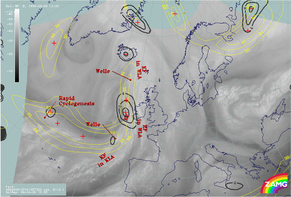
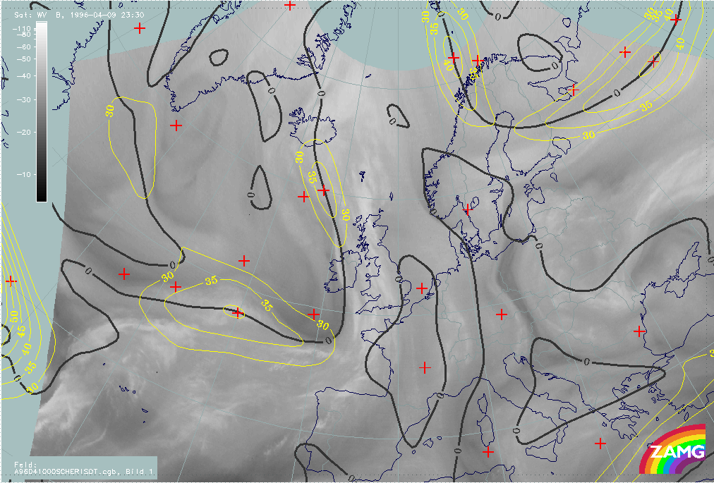
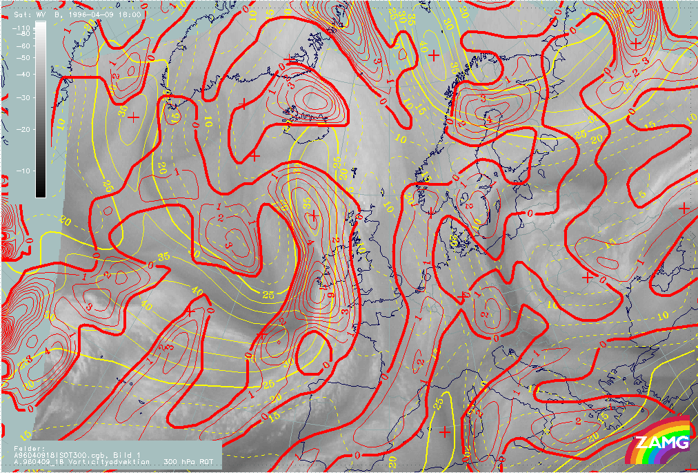
09 April 1996/12.00 UTC - Meteosat WV image; black: positive vorticity advection (PVA) 300 hPa, yellow: isotachs 300 hPa
|
|
|
The WV imagery is characterized by two black stripes within the area of the cloud head. The transition zone from white (moist air) to black (dry air) is a good indication for the location of the jet axis at approximately 300 hPa. The satellite image shows a jet axis along the poleward side of the cloud head which runs downstream along the rearward side of the frontal cloud band. A second much weaker transition zone can be found upstream of the merging zone between cloud head and frontal cloud band at approximately 43N/36W. The superimposed isotachs at 300 hPa confirm this interpretation of the WV imagery. Due to the large distance of the gridpoints of the model (about 150 km), the numerically computed isotachs show a broad zone extending within and at the poleward side of the cloud head. The only indication by the model that there are two jet streaks are the bulges of the isotachs within the areas of the entrance region (at approximately 44N/41W and 47N/35W).
Like the PVA at 500 hPa, the field of PVA at 300 hPa is also characterized by a very weak maximum within the area of the cloud head. This maximum may be attached to the right entrance region of the northern jet streak. It can often be observed that the cloud head indicating Rapid Cyclogenesis and which is also accompanied by severe weather events (like for instance thunderstorms, rain showers or gusty winds) is within the left exit region of the southern jet streak (for more information compare also Conceptual Models: Rapid Cyclogenesis ). The fact that this cloud head cannot be found within the left exit region of a jet streak (pronounced maximum of PVA at 500 as well as at 300 hPa) is another indication for no further development.
|
09 April 1996/12.00 UTC - Meteosat WV image; cyan: potential vorticity 310K, red: isobars; SatRep overlay: names of conceptual models
|
09 April 1996/12.00 UTC - Meteosat WV image; cyan: potential vorticity 305K, red: isobars
|

|
|
The two figures above include the potential vorticity on isentropic surfaces. Investigations have shown that the potential vorticity is a good indicator for whether the cloud head develops within its maturing stage through a cyclone-like cloud spiral, or dissolves after a couple of hours (for more information compare also Conceptual Models: Rapid Cyclogenesis ). On the higher isentropic surface (Theta = 310K) as well as on the lower isentropic surface (Theta = 305K) no anomaly of the potential vorticity (values between 1 and 2 *10-6m2K sec-1kg-1) can be observed within the area of Rapid Cyclogenesis. At both heights the anomaly can be found displaced far to the north of the cloud head. In the case of cloud heads where, during the maturing stage a cloud spiral develops, the anomaly often can be observed down to approximately 400 to 550 hPa. Due to the missing anomaly of the potential vorticity, no development of the cloud head to a cyclone-like cloud spiral can be expected. The cloudiness of the Rapid Cyclogenesis should dissolve after a couple of hours (compare also the fourth part of this case study "Special Investigation": Rapid Cyclogenesis).
09 - 10 April 1996 - Forecast For Cold Front
|
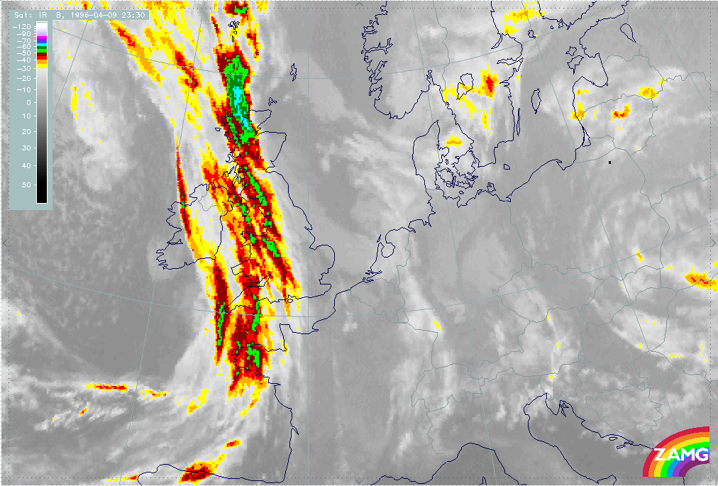
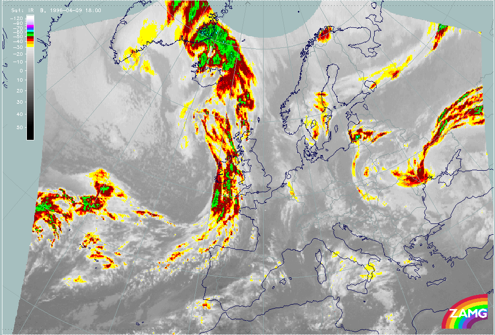
09 April 1996/18.00 UTC - Meteosat IR image; weather events (green: rain and showers, blue: drizzle, cyan: snow, purple: freezing rain,
red: thunderstorm with precipitation, orange: hail, black: no actual precipitation or thunderstorm with precipitation)
|
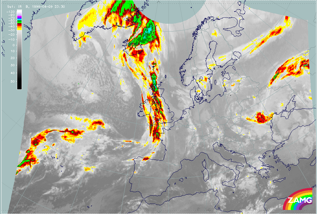
10 April 1996/00.00 UTC - Meteosat IR image; weather events (green: rain and showers, blue: drizzle, cyan: snow, purple: freezing rain,
red: thunderstorm with precipitation, orange: hail, black: no actual precipitation or thunderstorm with precipitation)
|
|
|
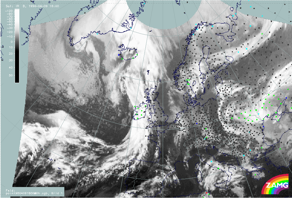
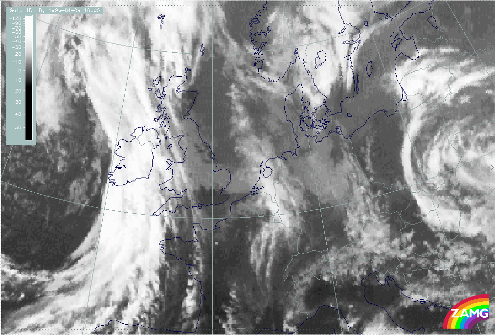
The satellite image at 18.00 UTC (left image) shows the cloud band of the Cold Front extending from the Canary Islands across Ireland to the Atlantic south-west of Iceland at approximately 60N/17W. The Cold Front is accompanied by a mesoscale substructure in the form of a Wave which can be found above and south of Ireland. The area of the wave is also accompanied within the satellite image by the coldest cloud tops (compare Forecast for Wave ). Although the frontal cloudiness is mostly situated above the Atlantic, the synoptic stations within the system (Ireland) report rain and showers (green crosses).
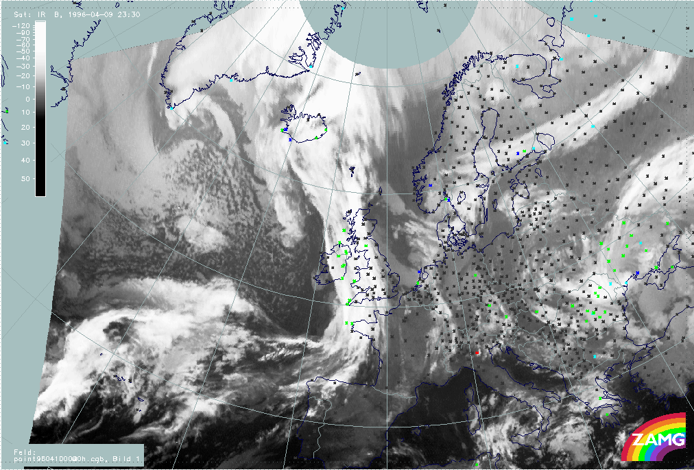
At 00.00 UTC the Cold Front can be found in the satellite image (right image) extending from the Atlantic north-west of the Iberian Peninsula, over the British Isles to Iceland. The Wave is situated above Ireland (compare Forecast for Wave ). As at 18.00 UTC, major parts of the frontal cloudiness are situated above the Atlantic. The synoptic stations situated within the cloud band report drizzle (blue crosses), rain and showers (green crosses).
|
09 April 1996/18.00 UTC - Meteosat IR image; red: height contours 1000 hPa, green: height contours 500 hPa, yellow: positive vorticity
advection (PVA) 500 hPa
|
10 April 1996/00.00 UTC - Meteosat IR image; red: height contours 1000 hPa, green: height contours 500 hPa, yellow: positive vorticity
advection (PVA) 500 hPa
|
|
|
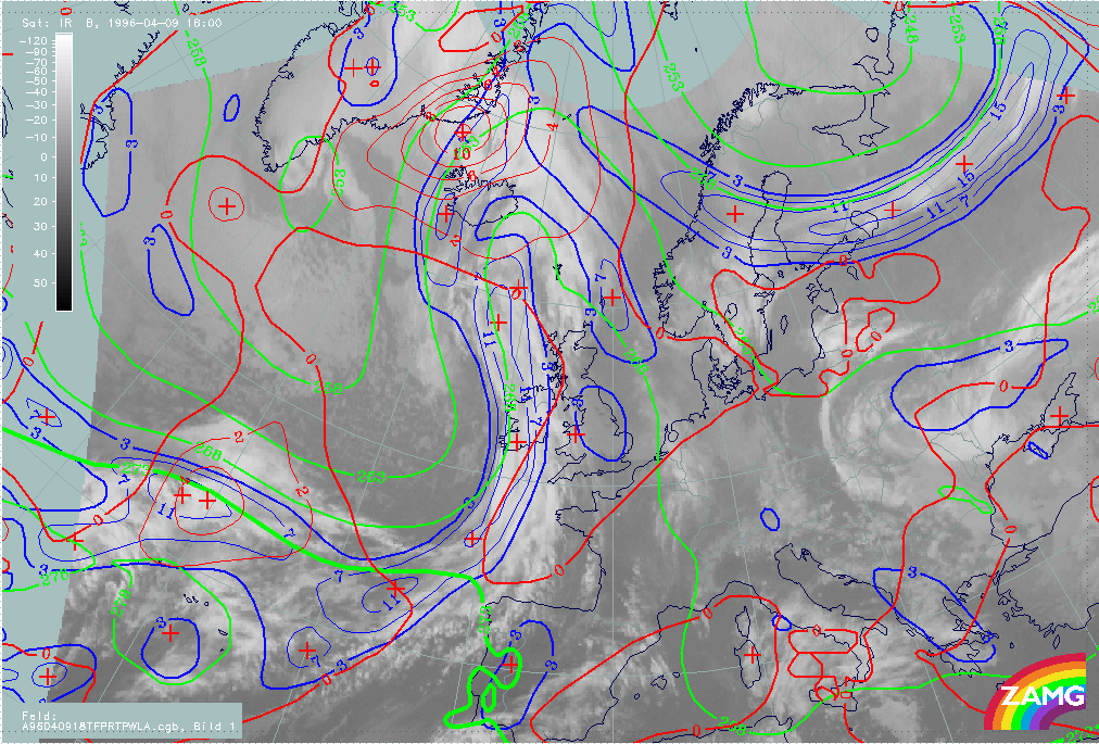
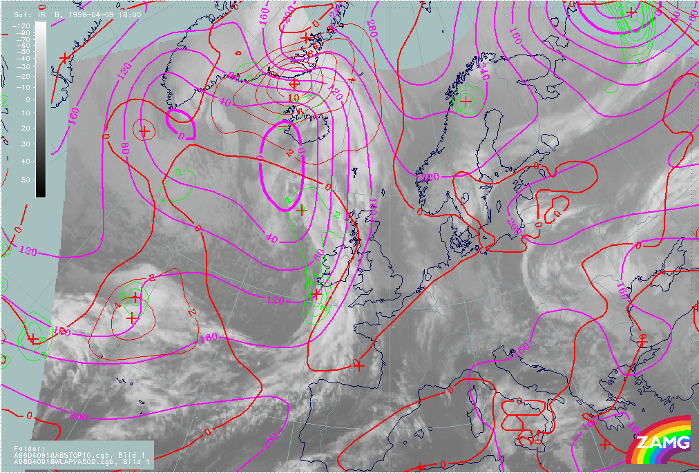
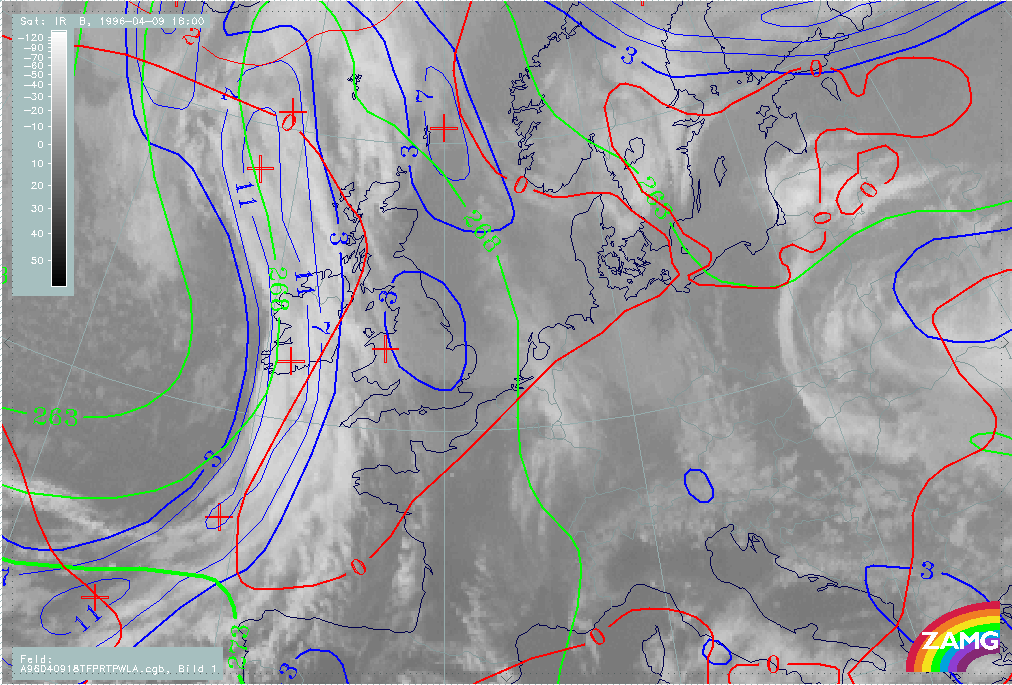
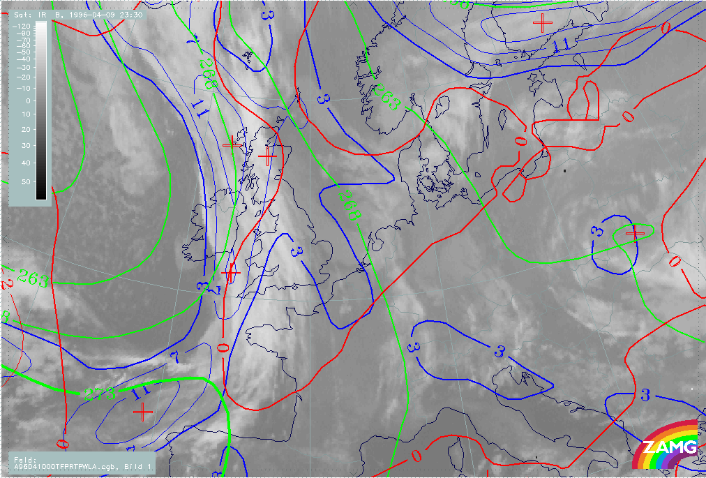
The left image above includes the absolute topography height contours at 1000 and 500 hPa at 18.00 UTC. The absolute topography at 1000 hPa contains a pronounced surface low stretching from the Atlantic at approximately 58N/18W to south-west Iceland. This configuration or form of surface low is typical for two weaker surface low centres. While the northern core of the low belongs to the frontal system situated north and east of Iceland, the southern one belongs to the described Cold Front. At both heights a well-developed trough can be observed at the rearside of the frontal cloud band at the downstream side of the Wave. This configuration of the absolute topography is typical for a still developing frontal system. The part of the Cold Front situated rear upstream of the Wave is, like the downstream part, also characterized by a trough at both heights. But in contrast to the situation north of the Wave this trough is much weaker, especially within the absolute topography at ground level (1000 hPa). This is the consequence of the frontal system approaching from the rear situated above the Atlantic north to north-west (compare also the fourth part of this case study "Special Investigation": Rapid Cyclogenesis).
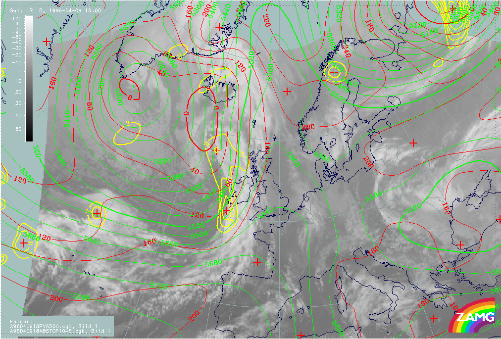
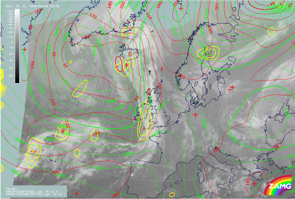
The third parameter which is superimposed on the image is the field of PVA at 500 hPa greater than 2 units. At 18.00 UTC (left image above) the northern part of the Cold Front and the area of the Wave is characterized by pronounced values of PVA. The field of PVA contains two maxima - a weaker maximum at the rear Cold Frontal cloud edge at approximately 58N/15W and a strong maximum within the area of the Wave which will be described in more detail within the sub-chapter Forecast for Wave . These pronounced values of PVA are a characteristic indication of an approaching or a deepening trough.
The right image above includes the absolute topography height contours at 1000 and 500 hPa at 00.00 UTC. At both heights a pronounced trough can be observed behind the Cold Front. Compared with the left image (18.00 UTC), a deepening of the trough within the last six hours can be observed. This deepening was already indicated by the pronounced values of PVA at 18.00 UTC (see also the paragraph above).
|
09 April 1996/18.00 UTC - Meteosat IR enhanced image
|
09 April 1996/18.00 UTC - Meteosat IR image; blue: thermal front parameter (TFP) 500/850 hPa, green: equivalent thickness 500/850 hPa,
red: temperature advection - WA 1000 hPa
|

|
|
|
|
|
09 April 1996/18.00 UTC - Meteosat IR image; blue: thermal front parameter (TFP) 500/850 hPa, yellow: shear vorticity 300 hPa
|
|
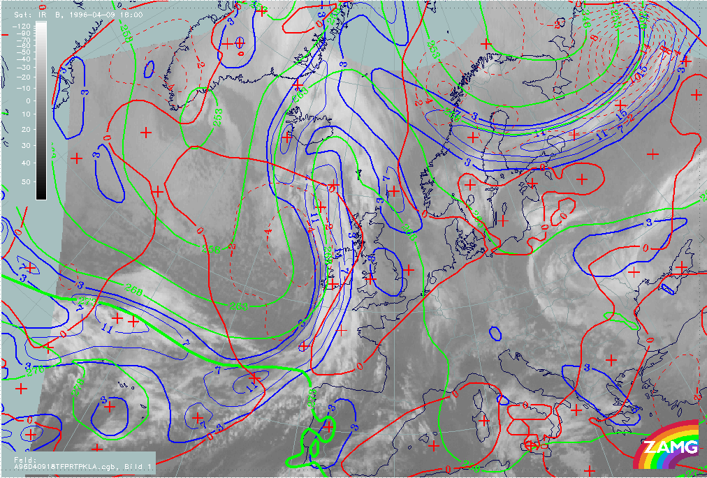
The satellite image (left image top) shows, especially within the northern part of the Cold Front (north of Wave), cold (high) cloud tops within the whole area of the Cold Front cloudiness. This is a very typical configuration for a so-called iI>Ana Cold Front. For an exact analysis of the Ana Cold Front the distribuion of the key parameters has to be investigated, which will be done within the next paragraph.
Looking at the thermal conditions at 18 UTC (right image top), the crowding zone of equivalent thickness can be found within the frontal cloud band of the Cold Front. As a consequence of the position of the crowding zone, the maximum values of the TFP can be found within the leading part of the frontal cloudiness. The third superimposed parameter is the field of temperature advection (warm advection). Typical for an Ana Cold Front, the frontal cloud band is within cold advection. The zero line of temperature advection can be found along the leading cloud edge. Another key parameter combination constitutes the next image (left image bottom): the TFP and the zero line of shear vorticity at 300 hPa. Like the parameter combination described above, this image confirms the fact that the Cold Front is of the Ana Cold Front type. In the case of an Ana Cold Front the zero line of the shear vorticity at 300 hPa (indicating the jet axis) is parallel to the rear edge of the frontal cloud band. The meteorological background of this distribution is that at higher levels on the cyclonic side of the jet the dry relative stream of the dry intrusion is parallel to the rear frontal cloud band. The result of this process is that only moist air is transported through the Cold Front cloudiness on the anticyclonic side of the jet. Therefore no cloud dissolution will take place, which leads to the typical split front character within the image of a Kata Cold Front (for more information compare also Conceptual Models: Cold Front and Conceptual Models: Split Front ).
|
09 April 1996/18.00 UTC - Meteosat IR image; blue: thermal front parameter (TFP) 500/850 hPa, green: equivalent thickness 500/850 hPa,
red: temperature advection - CA 1000 hPa
|
|
|
In contrast to the northern part of the Cold Front (north of the Wave), the southern part (south of the Wave) is mostly characterized by warmer (low) cloud tops (left image top). The reason for the mostly deeper cloudiness is that this part of the Cold Front is mainly of the type connected with cold advection. As described within the first part of this case study, further development depends on the distribution of the cold advection. In the case of this Cold Front it can be observed that there is no pronounced temperature contrast between the air situated in front of, and that behind, the Cold Front. The reason for the weak temperature gradient within this area is caused by the eastward moving frontal system situated immediately behind (see also the fourth part of this case study "Special Investigation": Rapid Cyclogenesis). Due to this missing temperature contrast no further development or frontogenesis can be expected (for information compare also Conceptual Models: Cold Front in Cold Advection ).
|
10 April 1996/00.00 UTC - Meteosat IR enhanced image
|
10 April 1996/00.00 UTC - Meteosat IR image; blue: thermal front parameter (TFP) 500/850 hPa, green: equivalent thickness 500/850 hPa,
red: temperature advection - WA 1000 hPa
|

|
|

|
|
|
10 April 1996/00.00 UTC - Meteosat IR image; blue: thermal front parameter (TFP) 500/850 hPa, yellow: shear vorticity 300 hPa
|
|
The satellite image (left image top) shows like the image from 18.00 UTC, cold (high) cloud tops within the area of the Wave (see sub-chapter Forecast for Wave ) and within the northern part (north of the Wave) of the cloud band of the Cold Front (Ana Cold Front). The southern part of the Cold Front (south of the Wave) is characterized by warm (low) cloud tops.
In comparison with the image from 18.00 UTC, the key parameters at 00.00 UTC look very similar. The crowding zone of the equivalent thickness (right image top) and the maximum values of the TFP can be found within the leading part of the frontal cloud band. The northern part of the Cold Front is within cold advection. The zero line of the temperature advection is situated very close to the leading cloud edge. The second parameter combination contains the TFP and the zero line of the shear vorticity at 300 hPa (left image bottom). Like the image six hours before, the zero line can be found parallel to the rear cloud edge of the Cold Front.
|
10 April 1996/00.00 UTC - Meteosat IR image; blue: thermal front parameter (TFP) 500/850 hPa, green: equivalent thickness 500/850 hPa,
red: temperature advection - CA 1000 hPa
|
|
|
The southern part of the Cold Front, the Cold Front in Cold Advection, is still within weak cold advection. Compared with the cloud tops from 18.00 UTC, it can be observed that the cloud tops from 00.00 UTC are much warmer (lower). This can be interpreted as indicating that due to the missing temperature contrast during the last six hours frontolysis and therefore cloud dissolution have taken place within this area of the Cold Front.
09 - 10 April 1996 - Forecast For Wave
|
09 April 1996/18.00 UTC - Meteosat IR enhanced image
|
|

|
The satellite image shows the wave above the Atlantic south of Ireland; this area is characterized by cold (high) cloud tops. This local intensification of the frontal cloudiness is a combination of two conceptual models:
- Wave (for more information compare also Conceptual Models: Wave )
- Intensification of frontal cloudiness within the left exit region of a jet streak (for more information see also Conceptual Models: Front Intensification by Jet Crossing )
|
09 April 1996/18.00 UTC - Meteosat IR image; magenta: height contours 1000 hPa, green: positive vorticity advection (PVA) 500 hPa, red:
temperature advection - WA 1000 hPa
|
09 April 1996/18.00 UTC - Meteosat IR image; yellow: isotachs 300 hPa, black: positive vorticity advection (PVA) 300 hPa
|
|
|
|
|
|
09 April 1996/18.00 UTC - Meteosat WV image; yellow: isotachs 300 hPa, black: shear vorticity 300 hPa
|
09 April 1996/18.00 UTC - Meteosat IR image; green: curvature vorticity 300 hPa, blue: shear vorticity 300 hPa
|
|
09 April 1996/18.00 UTC - Meteosat IR image; red: positive vorticity advection (PVA) 300 hPa
|
|
|
The satellite image (left image top) contains the relevant key parameters for a Wave. The absolute topography at 1000 hPa is characterized by a trough situated immediately upstream of the Wave. The field of temperature advection within the area of the Wave is not pronounced. The zero line of temperature advection changes within the area of the cloud bulge from the leading to the rear edge of the cloud band. This configuration of the zero line is typical for a weak maximum of warm advection situated downstream of the cloud bulge (at approximately 48N/07W). This distribution of the temperature advection indicates that there is little temperature contrast between the different air masses involved in the circulation of the Wave. The consequence of this meteorological process is that the field of temperature advection makes no contributions to the frontogenesis process. Therefore in this case the only parameter which is relevant for the increased cloudiness will be the field of PVA.
In contrast to the temperature advection, the field of vorticity advection contains a strong maximum of PVA at 500 and 300 hPa. For a classical distribution of vorticity advection in the case of a wave, this PVA maximum is situated too far downstream (for more information compare also Conceptual Models: Wave - Key parameters ). The reason for this displacement is that this area is also a left exit region of an approaching jet streak (compare right image top and left image middle). Therefore this PVA maximum is caused, especially at 300 hPa, by curvature vorticity as well as by shear vorticity (right image middle).
The WV images (right image top and left image middle) contain two combinations of the key parameters which are typical for intensification of frontal cloudiness within the left exit region of a jet streak. Compared with the isotachs in both images, it can be observed that there are also some deviations concerning the distribution of vorticity advection in the case of the Wave. The left image bottom contains the IR image with the superimposed field of PVA at 300 hPa. It can be observed that the model shows a broad zone of pronounced PVA values within this region. Due to the grid resolution of the model (150 km) there is no separation of PVA maxima between both conceptual models. Only a slight trough (at approximately 49N/11W) within the area of the left exit region can be interpreted as an indication for a second PVA maximum. However, both PVA maxima are situated very close to the jet axis. The left WV image (left image middle) contains the zero line of shear vorticity at 300 hPa, which is an indication of the jet axis. The reason for this distribution of the maxima can be found in the field of curvature vorticity at 300 hPa (right image middle). In the classical case, which describes a straight or only slightly curved jet streak, the PVA maximum is clearly separated from the jet axis. But in reality, as also in this case, the curvature of the jet streak is mostly stronger. The consequence of this orientation of the jet is that the PVA can be found on the cyclonic as well as on the anticyclonic side of the jet axis. The maximum of PVA can be found, due to the additional existing shear, on the cyclonic side very close to the jet axis (like for instance the trough at approximately 49N/11W) (for more information see also Conceptual Models: Front Intensification by Jet Crossing ). But, however, the main maximum of the PVA within this area can be found at the anticyclonic side of the jet. The reason for this is that the wave has a much stronger influence on the distribution of the PVA field than the intensification within the left exit region.
|
09 April 1996/00.00 UTC - Meteosat IR enhanced image
|
|

|
The satellite image at 00.00 UTC shows the wave above Ireland. During the last six hours there has been no further frontogenetic development (due to the missing temperature contrast at 18.00 UTC between the two air masses involved in the Wave development process). But besides this the wave has been modified from a so-called classical Wave to a combination of classical Wave and, especially within the upper levels of the troposphere, a so-called Jet Wave. Within the satellite image the area of the Wave is characterized by a well-developed cloud fibre extending from south Ireland to the Atlantic at approximately 58N/10W. This cloud fibre is a typical indication for a superimposed jet streak (for more information see also Conceptual Models: Upper Wave ).
|
10 April 1996/00.00 UTC - Meteosat IR image; magenta: height contours 1000 hPa, green: positive vorticity advection (PVA) 500 hPa, red:
temperature advection - WA 1000 hPa
|
10 April 1996/00.00 UTC - Meteosat WV image; isotachs 300 hPa, black: positive vorticity advection (PVA) 300 hPa
|
|

|
|
|
|
10 April 1996/00.00 UTC - Meteosat WV image; yellow: isotachs 300 hPa, black: shear vorticity 300 hPa
|
|
Looking at the relevant key parameters for the cloud intensification within the Wave area (left image), it can be observed that, as at 18 UTC, there is hardly any temperature contrast between the two air masses involved in the Wave development process. In contrast to this, the field of PVA contains a strong maximum at 500 hPa downstream of the wave bulge, indicating the deepening of the trough.
The upper levels of the troposphere (right image) are characterized by a jet stream situated parallel to the rear cloud edge of the frontal cloud band. Within the jet stream a jet streak can be found downstream of the Wave. The area is within the entrance region of this jet streak.
09 - 10 April 1996 - Mesoscale Cloud Band: Diagnosis For 09 April 12.00 UTC
|
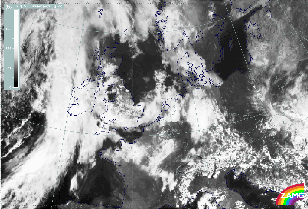
09 April 1996/12.00 UTC - Meteosat VIS image
|
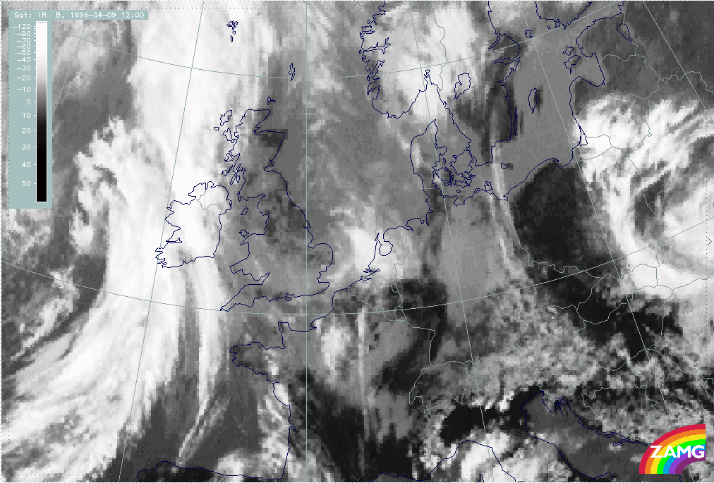
09 April 1996/12.00 UTC - Meteosat IR image
|
|
|
|
|
|
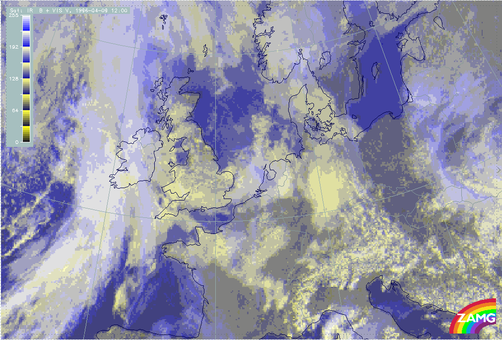
09 April 1996/12.00 UTC - Meteosat VIS + IR image
|
|
The satellite images at 12.00 UTC contain a cyclonically curved cloud band extending from the North Sea (approximately 53N/04W) across the coast of the Netherlands and south England to east Ireland where it merges with the frontal cloud band of the Cold Front in Warm Advection (compare Cold Front in Warm Advection ). Within the VIS image (left image top) this cloud band is characterized by high pixel values indicating high albedo. In contrast to this, within the IR image (right image top) this cloud band is mostly characterized by small values indicating warm cloud tops. Only above the North Sea in front of and above the north-west coast of the Netherlands, can high pixel values also be observed within the IR image. The distribution of the pixel values of both images leads to the fact that the cloud band consists mostly of deep cloudiness. Only above the North Sea has multi-level cloudiness developed within this system. This analysis can also be observed within the third image which is a special enhancement combination of the IR and VIS images (left image bottom):
- High pixel values within the VIS image and low pixel values within the IR image - yellow - indication for low level cloudiness,
- Low pixel values within the IR image and high pixel values within the VIS image - blue - indication for high level cloudiness,
- High pixel values within the VIS image and high pixel values within the IR image - white - indication for multi-level cloudiness.
As mentioned above, most of the pixel values within the cloud band are coloured/enhanced in yellow (low level cloudiness); only above the North Sea in front of and above the north-west coast of the Netherlands are they coloured/enhanced in white (multi-level cloudiness).
To get an overview, and for the analysis of this small scale cloud band, the relevant ECMWF analysis will be discused within the paragraphs below.
|
09 April 1996/12.00 UTC - Meteosat IR image; red: height contours 1000 hPa, green: height contours 500 hPa
|
09 April 1996/12.00 UTC - Meteosat IR image; red: wind vectors 1000 hPa, green: wind vectors 850 hPa
|
|
|
The left image above contains the superimposed height contours at 500 and 1000 hPa. This parameter combination describes the flow and pressure distribution near the surface and in the middle of the troposphere. While the field of the height contours at 500 hPa shows a ridge within the area of the small scale cloud band, the height contours at 1000 hPa are characterized by a trough. The form of the isobars at 1000 hPa is typical for a weak surface low. This assumption is confirmed by the second image which contains the superimposed wind vectors at 850 hPa and 1000 hPa (right image top). The centre of the low can therefore be found due to the distribution of the wind vectors above north-east France.
|
09 April 1996/12.00 UTC - Meteosat IR image; blue: thermal front parameter (TFP) 500/850 hPa, green: equivalent thickness 500/850 hPa,
red: temperature advection - WA 1000 hPa
|
09 April 1996/12.00 UTC - Meteosat IR image; blue: thermal front parameter (TFP) 500/850 hPa
|
|
|
The left image above, with the superimposed parameter combination of TFP, equivalent thickness and warm advection, describes the thermal situation within the lower and mid-levels of the troposphere. The equivalent thickness field contains no crowding zone within the area of the cloud band. The absence of the crowding zone can be interpreted as indicating that the model makes no differentiation between the air masses which are situated in front of and behind the cloud band. As a consequence, no pronounced baroclinicity exists. Looking at the distribution of the TFP it can be seen that there is only a very weak TFP within the cloud band above south England. Within the rest of the cloud band no TFP greater than 3 units can be observed. Compared with the superimposed TFP without thresholds (right image top) the whole cloud band can be found within an area where the TFP is very weak (values less than 3 units). The third parameter, the field of warm advection, shows that the cloud band is within weak warm advection. There is no pronounced temperature gradient between the air masses situated in front of and behind the cloud band, which can also be interpreted as indicating that no intensification or development of the cloud band can be expected.
Summing up, from this point of view the ECMWF model does not analyse this cloud band. The reason for this probably can be found in the grid resolution of the model of about 150 km. The only hint or indication by the model is a very weak TFP which has values below 3 units.
Another possibility to get more information about this cloud band is to analyse computed cross sections through this system. With the help of this method the forecaster gets a lot of additional information about the vertical structure of meteorological systems.
|
09 April 1996/12.00 UTC - Meteosat IR image; ECMWF grid superimposed; position of vertical cross section indicated
|
|
|
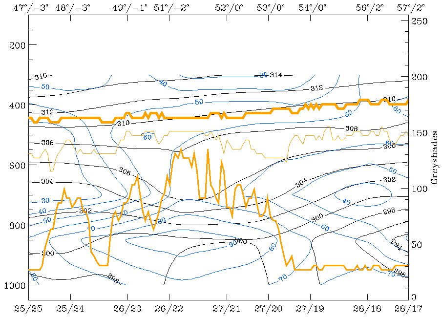
The image above contains the superimposed calculated cross section (dashed blue line) through the small scale cloud band.
|
09 April 1996/12.00 UTC - Vertical cross section; black: isentropes (ThetaE), blue: relative humidity, orange thin: IR pixel values,
orange thick: WV pixel values
|
|
|
The pixel values of the IR (thin) and especially of the VIS (middle) image show the cloud band between the ECMWF gridpoints starting at approximately 26/22 (rear cloud edge) to approximately 27/20 (leading cloud edge). Within this area the equivalent potential temperature is characterized by an upper level frontal system which can be found between 800 and 600 hPa. The distribution of the crowding zone of the equivalent potential temperature classifies the system as an Occlusion - like cloud band. The third parameter within the cross section is relative humidity. The vertical distribution of this parameter shows the position (horizontal and vertical extension) of the frontal cloudiness. Therefore high values can be found within and beneath the crowding zone of the equivalent potential temperature, greater than 80% whereas within the higher layers of the troposphere the humidity values are much lower, approximately 50 to 60%.
09 - 10 April 1996 - Mesoscale Cloud Band: Analysis For "Special Investigation": 09 April 18.00 UTC To 10 April 00.00 UTC
|
09 April 1996/18.00 UTC - Meteosat IR image
|
09 April 1996/18.00 UTC - Meteosat IR enhanced image
|
|
|
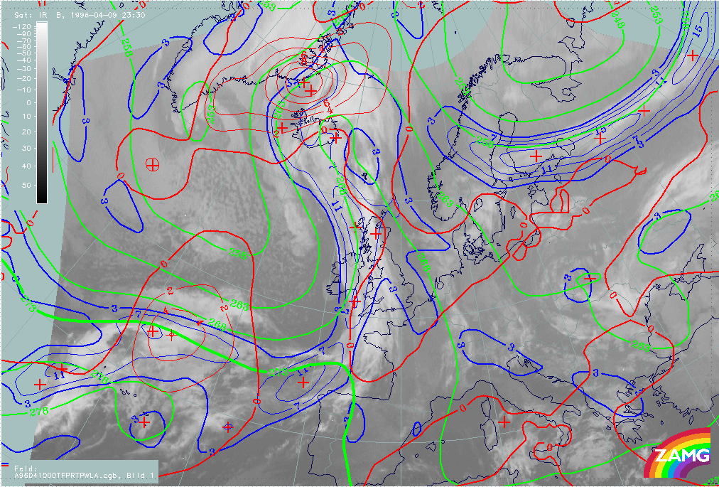
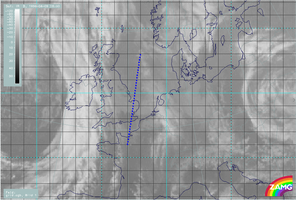
The satellite image at 18.00 UTC (left image) shows the small scale cloud band extending from the North Sea (at approximately 53N/04W) above the Netherlands, over south-east England to the west coast of England where it merges with the rest of the cloud band of the Cold Front in Warm Advection (compare Cold Front in Warm Advection ). Compared with the situation at 12.00 UTC (compare Mesoscale Cloud Band: Diagnosis for 09 April 12.00 UTC ) the cloud band still consists of low (warm) cloud tops. Only above the Netherlands can higher cloud tops be observed (right image).
|
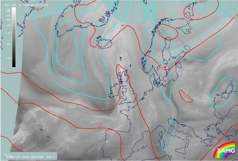
09 April 1996/23.30 UTC - Meteosat IR image
|
09 April 1996/23.30 UTC - Meteosat IR enhanced image
|
|
|
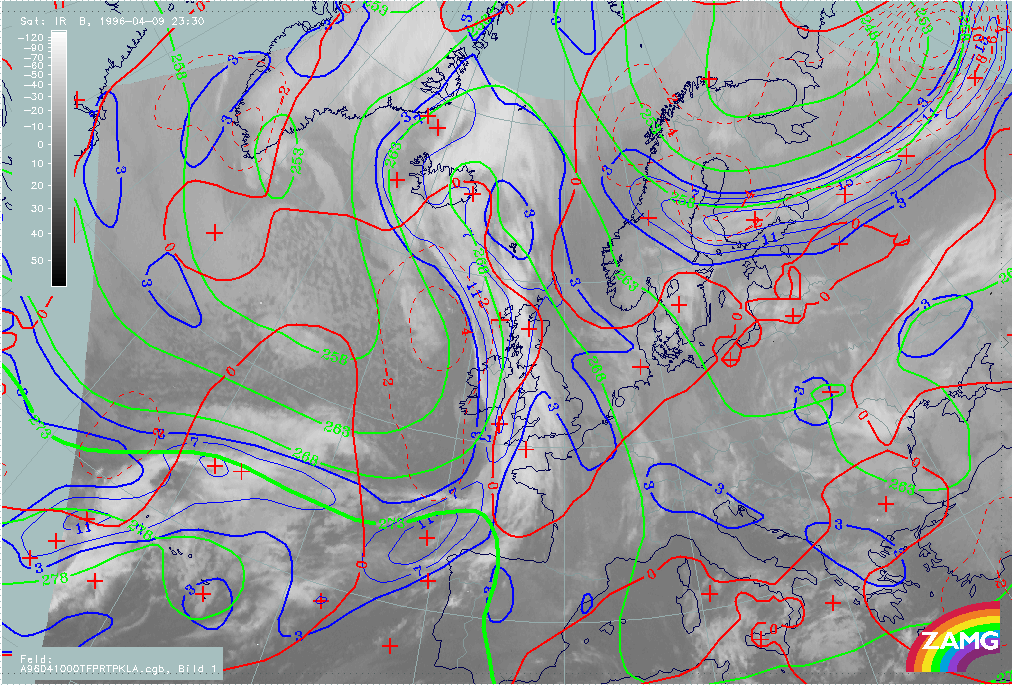
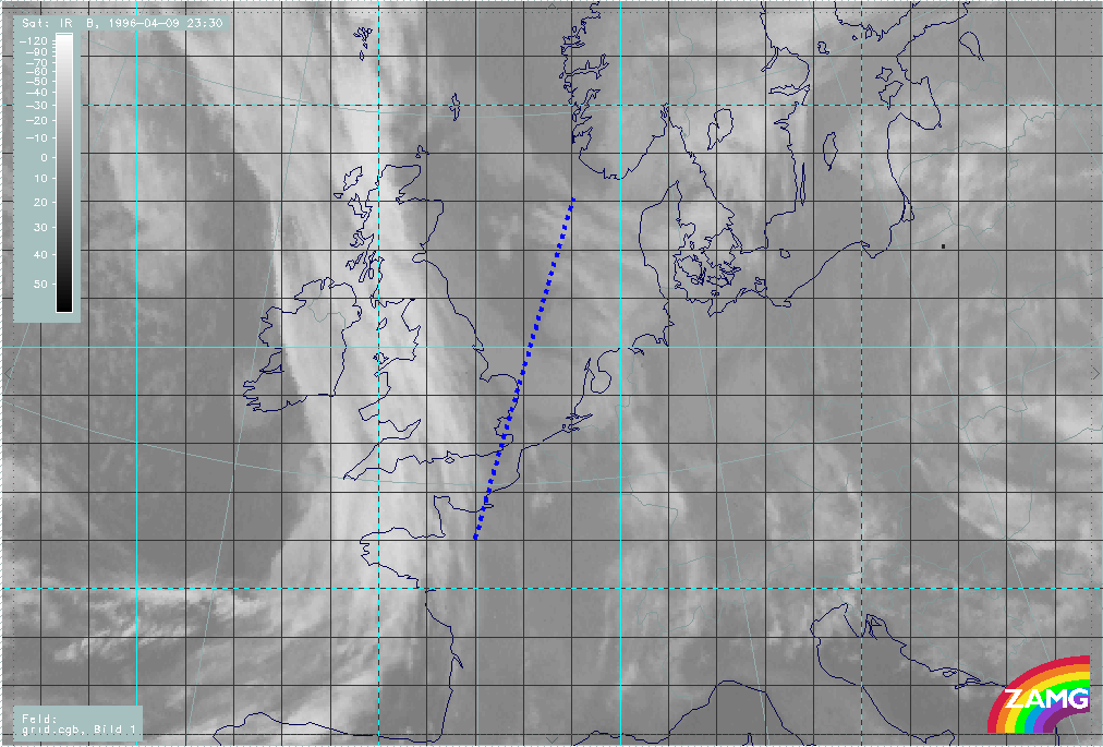
At 23.30 UTC the image (left image) shows the cloud band extending from the North Sea (at approximately 54N/05E) crossing the Netherlands and the North Sea coast of England to south-east Scotland where it merges with the frontal cloud band. Compared with the image from 18.00 UTC it can be observed that the cloud tops within the eastern part are getting warmer, especially the tops above the Netherlands (right image).
|
09 April 1996/18.00 UTC - Meteosat IR image; blue: thermal front parameter (TFP) 500/850 hPa, green: equivalent thickness 500/850 hPa,
red: temperature advection - WA 1000 hPa
|
09 April 1996/00.00 UTC - Meteosat IR image; blue: thermal front parameter (TFP) 500/850 hPa, green: equivalent thickness 500/850 hPa,
red: temperature advection - WA 1000 hPa
|
|
|
Superimposed on both images above is the parameter combination of thermal front parameter, equivalent thickness and field of warm advection, which describes the thermal situation within the lower part (up to 500 hPa) of the troposphere. As at 12.00 UTC (compare Mesoscale Cloud Band: Diagnosis for 09 April 12.00 UTC ) the ECMWF model at this point does not analyze this cloud band at all. The field of equivalent thickness shows neither a crowding zone at 18.00 UTC (left image) nor at 00.00 UTC (right image) within the area of the small scale cloud band. The second superimposed parameter, the TFP, has at 18.00 UTC only values of approximately 3 units above the southern part of England (western part of the cloud band). Within the rest of the cloud band (eastern part) the front parameter has values less than 3 units. The situation at 00.00 UTC is nearly the same as at 18 UTC. Within the western part, above the North Sea coast of England, the TFP is characterized by values of about 3 units. Within the cloud band east of approximately 05E the values of the front parameter are below the threshold of 3 units. The third superimposed parameter is the field of warm advection. As iat 12 UTC the whole small scale cloud band is within weak warm advection.
Summing up, when using the model at this point, it is not possible to classify clearly this cloud band. Therefore to classify this system a vertical cross section through the cloud band must be used.
|
09 April 1996/18.00 UTC - Meteosat IR image; ECMWF grid superimposed; position of vertical cross section indicated
|
09 April 1996/23.30 UTC - Meteosat IR image; ECMWF grid superimposed; position of vertical cross section indicated
|
|
|
Both images above contain the superimposed location of the computed cross sections (dashed blue line).
|
09 April 1996/18.00 UTC - Vertical cross section; black: isentropes (ThetaE), blue: relative humidity, orange thin: IR pixel values,
orange thick: WV pixel values
|
09 April 1996/23.30 UTC - Vertical cross section; black: isentropes (ThetaE), blue: relative humidity, orange thin: IR pixel values,
orange thick: WV pixel values
|
|
|
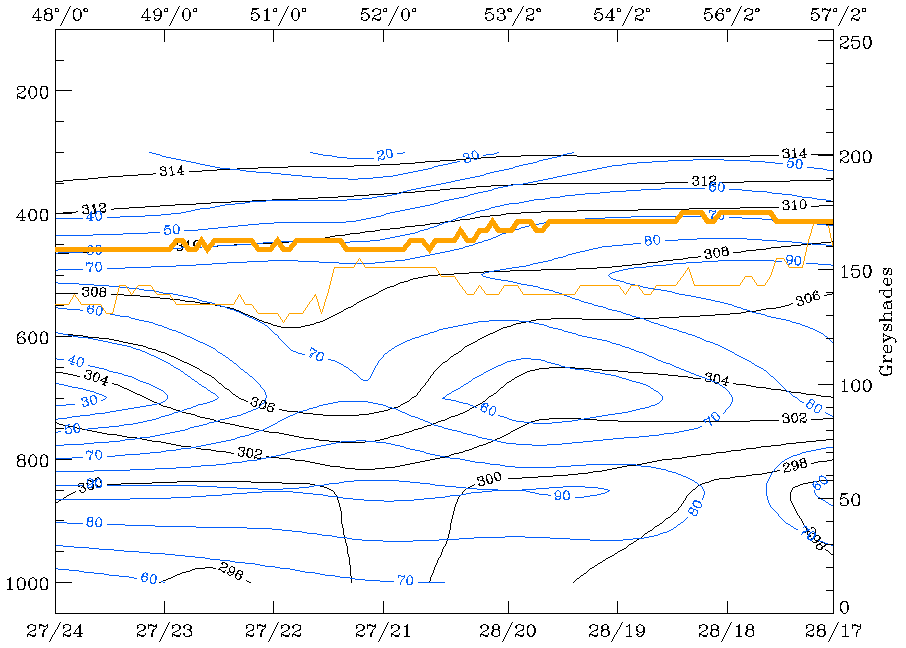
The cross section from 18.00 UTC (left image) shows the cloud band (pixel values of the IR grey shades) between the ECMWF gridpoints 27/22 and 28/20. Like the cross section at 12.00 UTC (compare Mesoscale Cloud Band: Diagnosis for 09 April 12.00 UTC ) the field of the equivalent potential temperature contains an Occlusion - like crowding zone between 800 and 500 hPa. The third superimposed parameter, the field of relative humidity, shows in the cloud band area high values of about 70 to 90% within the lower layers of the troposphere (from the surface up to approximately 750 hPa).
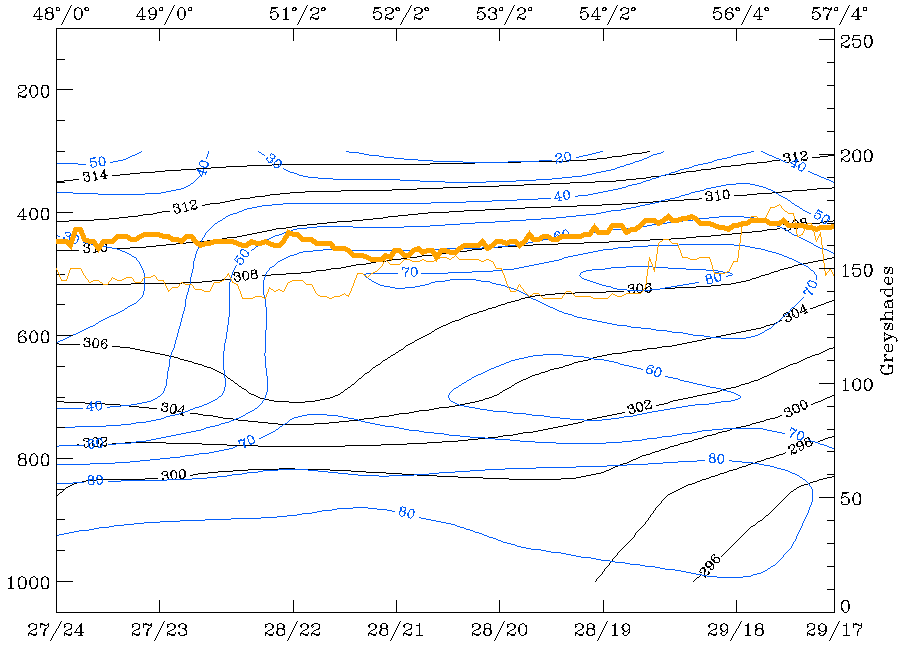
The right cross section shows the vertical distribution of the equivalent potential temperature and of the relative humidity at 00 UTC. Within this cross section the cloud band is situated between the ECMWF gridpoints of approximately 28/22 and approximately 28/20. In contrast to the cross section at 18.00 UTC, the equivalent potential temperature shows already a weaker crowding zone, especially at the cloud edge which is situated in front of the approaching front (left area within the cross section). This is caused by the continously decreasing area between this small scale cloud band and the frontal cloud band. The result of this process is that the air between both systems is getting warmer and the typical Occlusion - like trough of the isentropes is not as pronounced as within the cross sections at 12 and 18 UTC. The third parameter, the field of relative humidity, shows again high values within the lower layers of the troposphere and lower values within the higher layers.
Summing up, this case study is an example where cross sections are an additional tool to classify, to derive more information or even to gain a better understanding of the meteorological background of weather systems.
09 - 10 April 1996 - Rapid Cyclogenesis: Diagnosis For 09 April 12.00 UTC
|
09 April 1996/12.00 UTC - Meteosat IR image; SatRep overlay: names of conceptual models
|
09 April 1996/12.00 UTC - Meteosat IR enhanced image
|
|
|
|
|
|
09 April 1996/12.00 UTC - Meteosat WV image; SatRep overlay: names of conceptual models
|
|
The satellite image shows at 12.00 UTC a typical situation for rapid cyclogenesis above the Atlantic at approximately 45N/35W (for more information see also Conceptual Models: Rapid Cyclogenesis ). Within the image a frontal cloud band accompanied by partly cold (high) cloud tops (right image top) can be observed, extending from the Atlantic eastward to approximately 43N/21W. The area of Rapid Cyclogenesis is characterized by a bulge-like cloud head configuration. In contrast to the frontal cloud band, the cloud tops of the cloud head are much warmer (lower). In the WV image (left image bottom) two black stripes (dry air) can be observed, which is typical for a Rapid Cyclogenesis. Both transition zones are an indication for the jet axis, which mostly corresponds with a height of approximately 300 hPa. Very often the dry zone between frontal cloud band and the cloud head is calleda dry tongue.
|
09 April 1996/12.00 UTC - Meteosat IR image; magenta: height contours 1000 hPa, green: positive vorticity advection (PVA) 500 hPa, red:
temperature advection - WA 1000 hPa
|
|
|
The figure above shows a nearly classical distribution of the relevant key parameters (see also the first part of this case study Introduction and Conceptual Models for 09 April 1996/06.00 UTC). A surface low lies upstream of the merging zone between cloud head and frontal cloud band. The merging zone is also characterized by strong warm advection. The maximum of warm advection can be found situated a little upstream of the merging zone, which is also typical for a Rapid Cyclogenesis. The field of PVA contains only a very weak maximum at 500 hPa. The reason for this is that the cloud head is not in the left exit region of a jet streak but in the area of the entrance region.
|
09 April 1996/12.00 UTC - Meteosat WV image; yellow: isotachs 300 hPa, black: shear vorticity 300 hPa
|
|
|
The image above contains a broad zone of high wind velocities at 300 hPa. Due to the large distance between grid points (about 150 km) the model does not differentiate between the northern jet streak (poleward side of the cloud head) and the southern (between cloud head and frontal cloud band). This is also indicated by the zero line of shear vorticity which runs within the area of the cloud head nearly in the centre of the jet axis indicated in the WV imagery. The only indication by the model that two jet streaks exist can be found in the bulge-formed isotachs situated upstream of the cloud head. Within the WV imagery both jet axes can be clearly identified due to the sharp transition zones between moist (anticyclonic side of jet) and dry air (cyclonic side of jet).
|
09 April 1996/12.00 UTC - Meteosat IR image; cyan: potential vorticity 310K, red: isobars
|
09 April 1996/12.00 UTC - Meteosat IR image; cyan: potential vorticity 305K, red: isobars
|
|

|
The two figures above show the potential vorticity on isentropic surfaces. Investigations have shown that potential vorticity is a good indicator for whether the cloud head develops within its maturing stage through a cyclone-like formed cloud spiral, or dissolves after a couple of hours. The indication for this development is given by the so-called PV anomaly (values of the PV between 1 and 2 *10-6m2K sec-1kg-1). This anomaly is connected with a lowered tropopause which overruns a low level baroclinic zone. It induces a cyclonic circulation within the upper levels of the troposphere which weakens towards the ground. As a consequence of warm advection, a low-level PV anomaly develops slightly east of the upper-level PV anomaly. Due to the vertical motion within the area of these anomalies, an alternate intensification takes place. This leads first to a downward and an upward growing which ends in a coupling of both anomalies. The result of this process is a cyclonic circulation throughout the whole troposhere (for more information see also Conceptual Models: Rapid Cyclogenesis ). The images above include the potential vorticity on two isentropic surfaces:
- On the isentropic surface of 310K (higher surface) (left image)
- On the isentropic surface of 305K (lower surface) (right image)
In the ideal case the PV anomaly should be situated between the frontal cloud band and the cloud head (area of the dry tongue - Black Stripe in the WV image). In the case of cloud heads where, during the maturing stage a cloud spiral develops, the anomaly often can be observed down to approximately 400 to 550 hPa. Within both images no potential vorticity anomaly can be observed within the area of Rapid Cyclogenesis. The IPV anomaly can at both heights be found displaced too far to the west. This leads to the fact that no dry stratospheric air has protruded downward between 400 to 550 hPa. Due to the missing potential vorticity anomaly no development of the cloud head to a cyclone-like formed cloud spiral can be expected. Therefore the cloudiness of the Rapid Cyclogenesis will dissolve after a couple of hours.
The reason why there is no further development often has two possibilities:
- The PV anomaly is too high, with the result that the induced cyclonic circulation does not reach the lower levels of the troposphere - as described above, the typical heights for the PV anomaly can be found between 400 to 550 hPa;
- The static stability is too high - the induced circulation may only reach the ground if the static stability is sufficiently low.
09 - 10 April 1996 - Rapid Cyclogenesis: Analysis For "Special Investigation": 09 April 18.00 Utc To 10 April 00.00 UTC
|
09 April 1996/18.00 UTC - Meteosat IR enhanced image
|
10 April 1996/00.00 UTC - Meteosat IR enhanced image
|
|
|
|
|
|
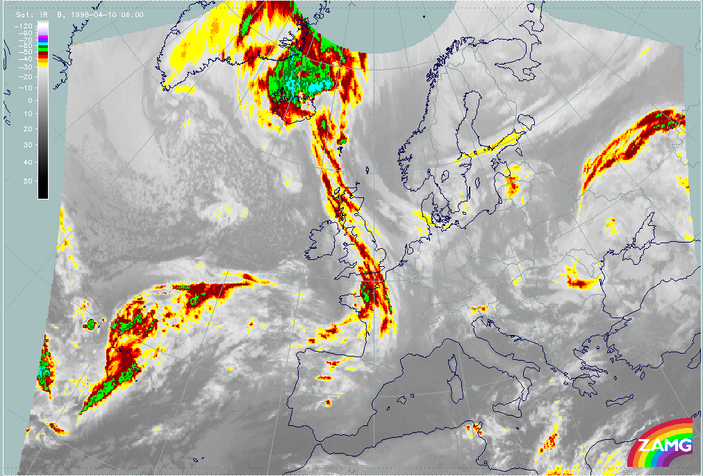
10 April 1996/06.00 UTC - Meteosat IR image
|
|
Compared with the image from 12.00 UTC, at 18.00 UTC (left image top) the area of the cloud head is characterized by a small area of cold (high) cloud tops at approximately 45N/30W. In the paragraphs below, we will see that this local intensification is due to the right entrance region of the northern jet streak. The rest of the cloud head shows no significant intensification. The entrance region of the southern jet streak is indicated by cold (high) cloud tops within the leading part of the frontal cloud band at approximately 43N/30W. Six hours later (right image top) the cloud tops of the cloud head are getting warmer (lower) even in the right entrance region, which at 00.00 UTC is less pronounced than at 18.00 UTC. Only in the right entrance region of the jet streak core, at approximately 48N/21W, can colder cloud tops (but also warmer than six hours before) be observed. At 06.00 UTC (left image bottom) nearly the whole cloud head has dissolved. The rest of the cloud head can be found at approximately 48N/26W.
|
09 April 1996/18.00 UTC - Meteosat IR image; magenta: height contours 1000 hPa, green: positive vorticity advection (PVA) 500 hPa, red:
temperature advection - WA 1000 hPa
|
10 April 1996/00.00 UTC - Meteosat IR image; magenta: height contours 1000 hPa, green: positive vorticity advection (PVA) 500 hPa, red:
temperature advection - WA 1000 hPa
|

|

|
|
|
|
09 April 1996/19.00 UTC - Meteosat WV image; yellow: isotachs 300 hPa, red: positive vorticity advection (PVA) 300 hPa
|
10 April 1996/00.00 UTC - Meteosat WV image; yellow: isotachs 300 hPa, red: positive vorticity advection (PVA) 300 hPa
|
The parameters in both images (left and right image top) represent a classical distribution. Therefore a low or a well-developed trough (left image top - this configuration of the isolines is typical for a weak low) at ground level can be found in both images situated at the rear of the frontal cloud band upstream of the cloud head. The field of temperature advection is characterized by pronounced warm advection. The maximum of warm advection again can be found very close to the merging zone between the frontal cloud band and the cloud head cloudiness. The third superimposed parameter, the field of PVA at 500 hPa, contains a maximum upstream of the merging zone. Within the area of the PVA the coldest cloud tops can be observed. As at 12.00 UTC both maxima are not situated within the left exit region of a superimposed jet streak at 300 hPa, but in the area of the right entrance region (left and right image bottom).
The model again shows a broad zone of high wind velocities (left and right image bottom) above the cloud head and does not separate between the northern and the southern oriented jet streak. The only indication by the model that two jet streaks exist can be found in the bulges of the isotachs within the area of the entrance region. The second superimposed parameter is the field of PVA at 300 hPa which shows two PVA maxima in the area of the right entrance region of both jet streaks (left image bottom). Compared with the coldest cloud tops, both maxima are shifted about two degrees too far to the west. At 00.00 UTC the jet streak and PVA within the right entrance region are less pronounced, which can also be seen by the lower (warmer) cloud tops.
|
09 April 1996/18.00 UTC - Meteosat WV image; cyan: potential vorticity 310K, red: isobars
|
10 April 1996/00.00 UTC - Meteosat WV image; cyan: potential vorticity 310K, red: isobars
|
|
|
Both images above show the field of PV at the isentropic surface of 310K. In both images the IPV anomaly is situated too far northward of the Rapid Cyclogenesis. Therefore the PV has no effect on the development of the cloud head.