12 March 1996 - Cold Front And Baroclinic Boundary To Upper Level Low
|
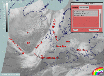
12 March 1996/06.00 UTC - Meteosat IR image; SatRep overlay: names of conceptual models, SatRep menu: key parameters for Cold Front
forecast
|
|
Concerning the forecast of the conceptual model "Cold Front" in the SatRep Menu a button "Vorhersage = forecast" has to be clicked on, then the relevant menu appears. As can be seen in the right upper corner, two kinds of forecasts and forecast times are presented:
The very short range forecast VSRF (06.00 - 18.00 UTC, 12 hours)
For the very short range forecast, six-hourly forecasts from ECMWF are used. Those parameters which are key parameters of a conceptual model are prepared as overlays on the satellite image in three different colours representing the three points of time 06.00, 12.00 and 18.00 UTC:
- yellow: 06.00 UTC
- green: 12.00 UTC
- blue: 18.00 UTC
In the case of the conceptual model "Cold Front", the thermal front parameter (TFP) and maxima of positive vorticity advection (PVA500>=2 units) are taken into account.
Nowcasting (0-2 hours)
For this forecast time, atmospheric motion vectors (AMVs) are used which extrapolate the cloud systems for the next two hours. These nowcasts are renewed half-hourly or hourly and are not discussed here.
|
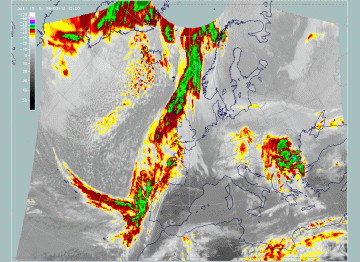
12 March 1996/06.00 UTC - Meteosat IR image; yellow: thermal front parameter (TFP) 500/850 hPa 06.00 UTC, green: thermal front
parameter (TFP) 500/850 hPa 12.00 UTC, blue: thermal front parameter (TFP) 500/850 hPa 18.00 UTC
|
|
The most important parameter in this case is the forecast of the TFP. There is a rather fast displacement of the part of the front south of the Wave, which means that the front reaches the Spanish west coast and Portugal at 18.00 UTC. As mentioned for 06.00 UTC (compare Cold Front ) the TFP in this part is close to the rear side of the cloud band, which means for the forecast that Portugal should already be under the influence of the frontal cloud band by this time. This fast moving southern part is an area where Wave and jet intensification take place and therefore it is also discussed in the "special investigation" (compare Diagnosis for 12 March 06.00 UTC ).
North of the Wave the front is nearly stationary, especially above the British Isles. Further north of Scotland the formation of an Instant Occlusion process, which is not discussed here, leads to a north-westerly movement again.
The Baroclinic Boundary reaching from the British Isles into the Mediterranean and forming the southern boundary of the Upper Level Low is stationary during the next 12 hours, which is expected considering the stationary state of the Upper Level Low. Only in the south-eastern part is a small shift recognizable.
|
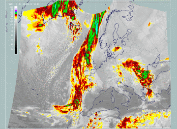
12 March 1996/06.00 UTC - Meteosat IR enhanced image
|
12 March 1996/12.00 UTC - Meteosat IR enhanced image
|
|
12 March 1996/18.00 UTC - Meteosat IR enhanced image
|
|
The images of the three points in time confirm this as a very good forecast.


