Theoretical Background
There are three stages of Polar Lows (see CM Polar Low): the developing stage, the mature stage and the decaying stage. In the developing stage
baroclinicy in combination with positive vorticity advection and potential vorticity in the upper levels is important for the development of
such a low. Convection is the driving force in the mature stage.
In most cases a Polar Low develops in a secondary baroclinic zone in polar or arctic air. This baroclinic zone can for instance originate from
the edges of ice fields in the far north of the Atlantic or from the remnants of Occlusions or Arctic Fronts. The cloudiness in this zone is
the result of positive vorticity advection and warm air advection. As it combines with extremely cold air in the upper levels, the atmosphere
becomes potentially unstable. The development of a Polar Low starts with the crossing of an upper level disturbance. This disturbance can be an
upper level trough, a jet-streak or an area of positive vorticity advection. The further development of a Polar Low continues when a low level
disturbance interacts with the upper level disturbance, especially in cases where artic air is flowing out over relatively warm sea water. The
big difference between the sea water temperature and the temperature of the air causes significant instability and temperature fluxes in the
lower layers of the troposphere. When a Polar Low reaches land the energy supply from the sea water is cut off. This, together with the
increased friction, causes the cohesion and structure of the Polar Low to rapidly decay. It sometimes occurs that Polar Lows, which developed
as result of very strong baroclinicy, are not dependant on sensitive and latent heat fluxes and continue to survive over land. This last
category of Polar Lows only disappears as a result of dynamic interactions, such as negative vorticity advection or cold air advection.
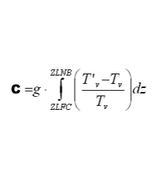
Polar lows are sometimes called arctic Hurricanes because they have some similarity to tropical Cyclones (spiral-shaped cloudiness, a cloud free eye). Theories concerning the development of tropical cyclones can also be (partly) applied to Polar Lows. One such theory is CISK. CISK means Conditional Instability of the Second Kind. An initial disturbance causes convergence and rising air, which in a conditionally unstable atmosphere causes the release of latent heat. This latent heat becomes available as a result of condensation of rising air. The air is heated and expands, consequently the surface pressure will start to fall. The pressure gradient increases with increasing convergence. This convergence causes upward motion of humid air, and so the process continues. This process of self-maintenance and strengthening is called positive feedback. The mechanism weakens over land, over colder seawater or when there is too much wind shear. The scale of CISK-forced disturbances is determined by the vertical distribution of diabatic heating during development. The growth rate depends on the amount of available potential energy (CAPE, Convective Available Potential Energy) in the atmosphere. During cold air outbreaks, which are extremely unstable, there is enough CAPE present for the development of Polar Lows. However, the question is whether there is enough CAPE over a longer period of time. The amount of CAPE (C) can be calculated using the following formula:
|
|
|
with
| C | maximum kinetic energy per unit mass | (m2s-2) |
| ZLFC | level of free convection | (m) |
| ZLNB | level of neutral buoyancy | (m) |
| g | magnitude of gravity | (ms-2) |
| T'v | temperature of the parcel | (K) |
| Tv | temperature of the environment | (K) |
Important for the convection to become organised is the appearance of an initial disturbance. This initial disturbance is often caused by baroclinic forcing, and sometimes by orographical or barotropic forcing. Moist convection plays a central role in the development of a lot of Polar Lows in contrast to the normal depressions which, in most cases, develop from a Wave in the polar front.
