Chapter V: Case studies
Table of Contents
Finland 10th of November 2010
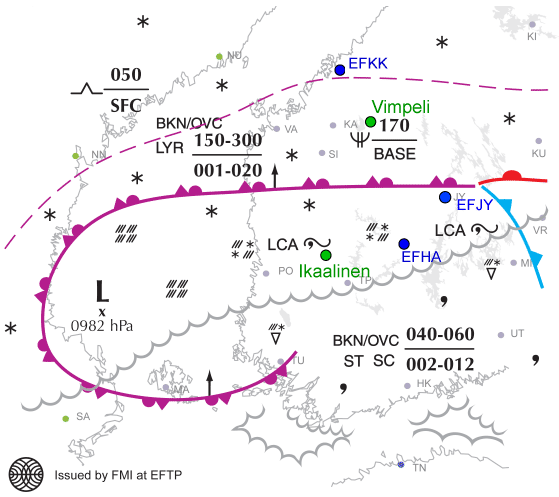
In this case there was icing in connection with a warm occluded front over Middle Finland on the 10th of November 2010. There had been snowfall during the night, so the air was relatively free of aerosols. This situation favors the collision-coalescence process, which is precisely the way large supercooled water drops form.
Freezing rain and freezing drizzle were observed from 05.20 UTC on at Halli airport (EFHA). A report of moderate icing came from Kokkola airport (EFKK) at 07.35 UTC.
Fig. 5.1. Significant Weather Chart for Western Finland by FMI 10th Nov 2010 for 06 UTC. Airports are marked blue, radars green.
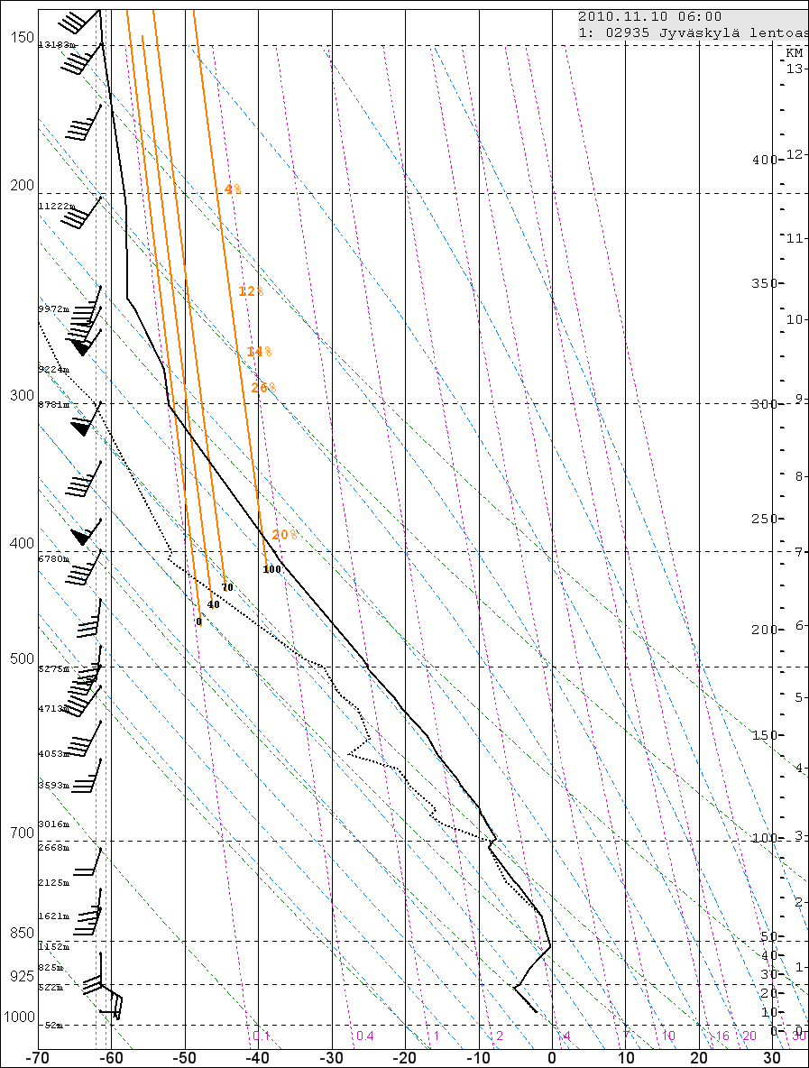
The sounding from Jyväskylä (near Halli) shows very clearly a thick stratiform water cloud from ground to 700 hPa. The temperature of this cloud varies between 0…-9 °C.
Fig. 5.2. Sounding from Jyväskylä 11th Nov 2010 at 06 UTC.
Satellite images
1. Meteosat, MSG instrument
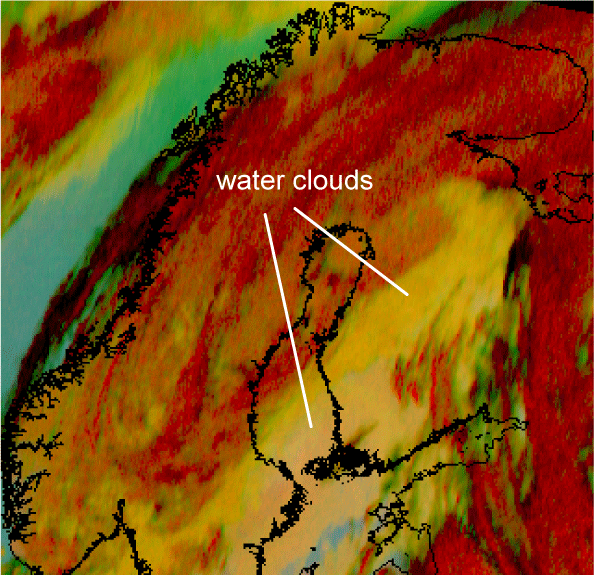
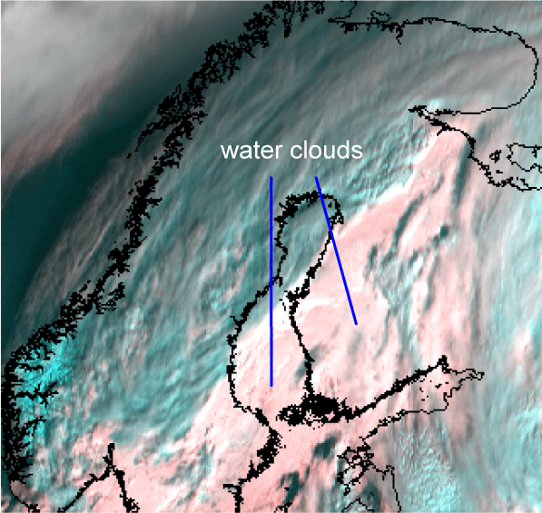
The water clouds can be seen clearly in both combination images. In 24hMicrophysical they appear orangish yellow, in HRVFog light pink.
Fig. 5.3. 24hMicrophysical combination on 10th Nov 2010 at 07.30 UTC
Fig.5.4. HRVFog combination on 10th Nov 2010 at 09.00 UTC
2. NOAA, AVHRR instrument
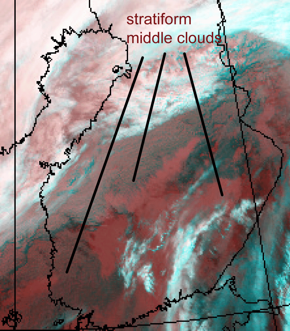
The 345 combination shows stratiform middle clouds reddish. The different shades of colour implies slightly different temperatures:
Fig.5.5. Combination 345 on 10th Nov 2010 at 07.10. UTC
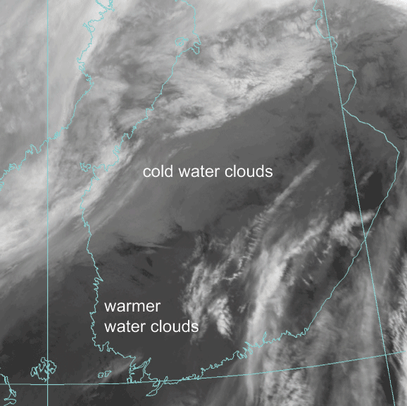
In this case the daytime images do not add any information that is not already in 345 combination – and also, daylight is sparse here. But the IR image 12.0µm reveals further details: the water cloud in Southwestern Finland is warmer than the cloud over Middle Finland. This suggests that the most severe icing occurs in Middle Finland:
Fig.5.6. Channel 12.0 µm on 10th Nov 2010 at 07.10 UTC
Radar
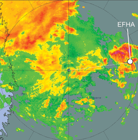
Freezing rain was observed in EFHA at 05.20 UTC. The CAPPI image shows strong echoes just north of it:
Fig. 5.7. CAPPI image 10 Nov 2010 at 05.30 UTC, from the Ikaalinen radar, with colors as a function of radar echoes/dBz
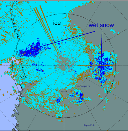
The hydrometeor classification product HCLASS shows wet snow in the same areas where the strongest echoes are:
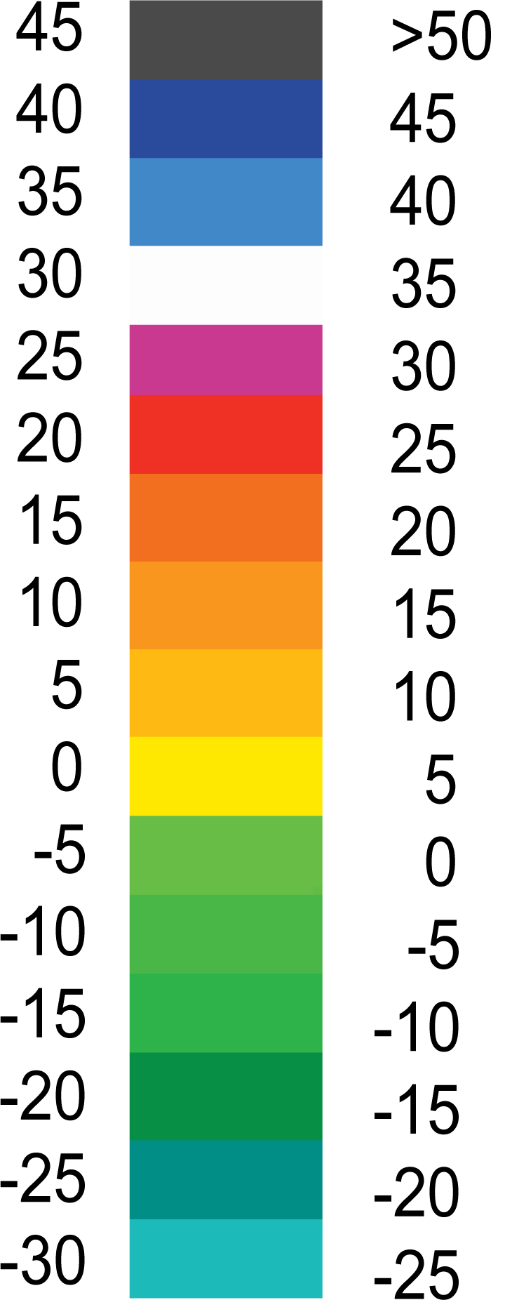
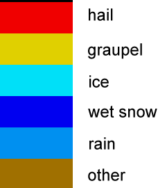
Fig.5.8. HCLASS product 10 Nov 2010 at 05.30 UTC from the Ikaalinen radar, with color scale
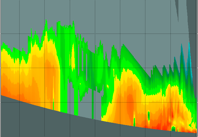
Moderate icing was reported in the vicinity of EFKK at 07.35 UTC. There are strong echoes in this area. The vertical cross section, taken along the black line, shows that the strongest echoes come mostly from under 1 km. From the sounding it can be seen that the temperature below 1 km is -2…-3°C, with water clouds.
Fig.5.9. CAPPI image 10 Nov 2010 at 05.20UTC from the Vimpeli radar, with colors as a function of radar echoes/dBz.
Fig.5.10. Vertical cross section radar image 10 Nov 2010 at 07.30UTC from the Vimpeli radar
Finland 30th of December 2010
Over Southern and Middle Finland there was widespread moderate to heavy freezing drizzle, which caused harm not only to aircraft but also to road traffic by freezing windscreens and road surfaces.
At 12.20 UTC a pilot reported moderate icing in the vicinity of Tampere airport (EFTP). One METAR reported weak freezing rain and another one snow grains, both in the Åland Islands.
The synoptical analysis shows two occluded fronts that slowly approached each other:
Fig. 5.11. Significant Weather Chart for Western Finland 30. Dec 2010 at 12 UTC by FMI. Radar locations are marked red, the Jokioinen sounding station green and the EFTP Airport blue.
The sounding in Jokioinen at 12 UTC shows a nearly neutral layer of 100 % humidity between 970 and 820 hPa. The temperature varies between -12°C and -9°C, with two small inversions. The soundings from the previous day were rather similar, but not as humid. The cloud thickened and in the end it began to precipitate.
Fig. 5.12. Sounding from Jokioinen 30. Dec. 2010 at 12 UTC
Satellite images
1. Meteosat, MSG instrument
Thick water clouds can be clearly seen in the 24hMicrophysical combination, where they appear orangish yellow. Clouds with small particles appear greenish, so they are potentially less icing than yellow clouds. Generally, large drop HRVFog is of no use at this time of year.
Fig.5.13. 24hMicrophysical combination 30. Dec 2010 at 10.15 UTC
2. NOAA, AVHRR instrument
The cold water cloud can be seen in the infrared image combination
(3,7 µm + 10,9 µm + 12,0µm). The stratiform cloud is clearly seen between the high frontal clouds (whitish), but as the ice cloud over Eastern Finland appears pinkish, there might well be water clouds beneath it.
Fig. 5.14. 345-combination Dec 2010 at 10.10 UTC
The fine structure of the cloud can be seen in the very high resolution infrared image (12,0µm). The cloud layer is fairly uniform, but it is lightly broken here and there.
Fig. 5.15. IR channel 12,0 µm 30th Dec 2010 at 10.10 UTC
Radar
The vertical cross section shows that there are intensive cells within the cloud layer:
Fig. 5.16.a. Cross section from the Kuopio radar 30. Dec 2010 at 13.15 UTC, with color scale
Fig. 5.16.b. Location of cross section
In the Vantaa radar CAPPI image there are intensive echoes among weaker ones:
Fig. 5.17. CAPPI image from the Vantaa radar 30. Dec.2010 at 12.00 UTC, with color scale.
In the hydrometeor classification radar product it can be seen that there is wet snow within the cloud, in the same locations as the strongest CAPPI echoes:
Fig. 5.18.a. HCLASS_PPI product from the Vantaa radar 10 Dec 2010 at 12.00 UTC, with color scale
France 14th of May 2011
In this incidence severe icing was reported by pilots at Bordeaux Airport. Icing occurred around 07.45 UTC between FL070 and FL120; in this case the corresponding temperature range is 0…-10 °C.
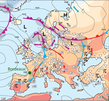
The synoptic situation in an analysis by FMI shows that a cold front with a developing wave passed over Bordeaux during the day:
Fig. 5.19. Frontal analysis 14 May 2011 at 12 UTC by FMI.
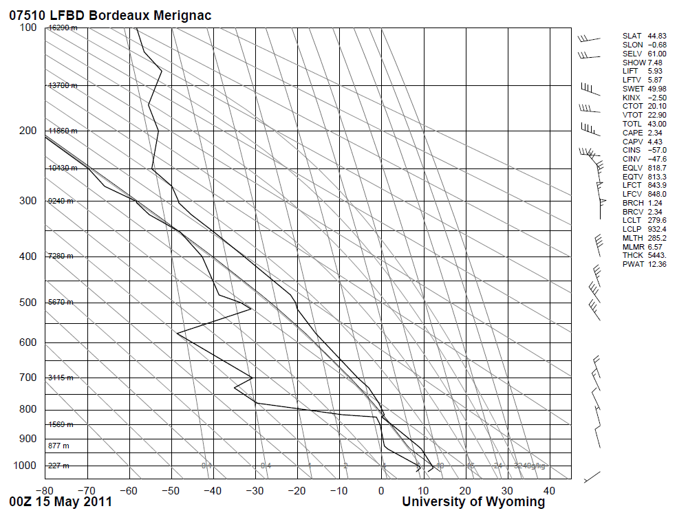
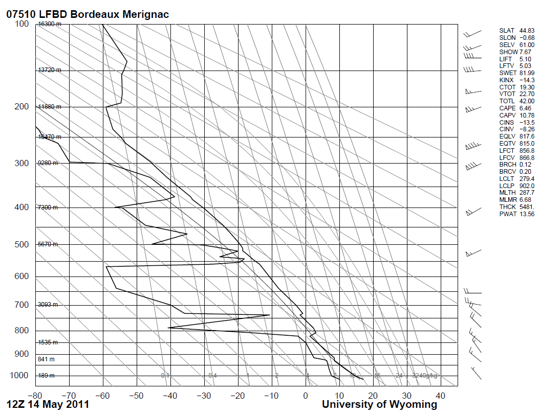
The soundings show a typical frontal passage (wind shear around 700 hPa at 12UTC), with no actual hint of icing conditions. This is due to the fact that the passage happened fairly quickly around 07-08 UTC, while the soundings are from 00 and 12 UTC.
Fig. 5.20. Sounding from Bordeaux 14 May 2011 at 00 UTC
Fig. 5.21. Sounding from Bordeaux 14 May 2011 at 12 UTC
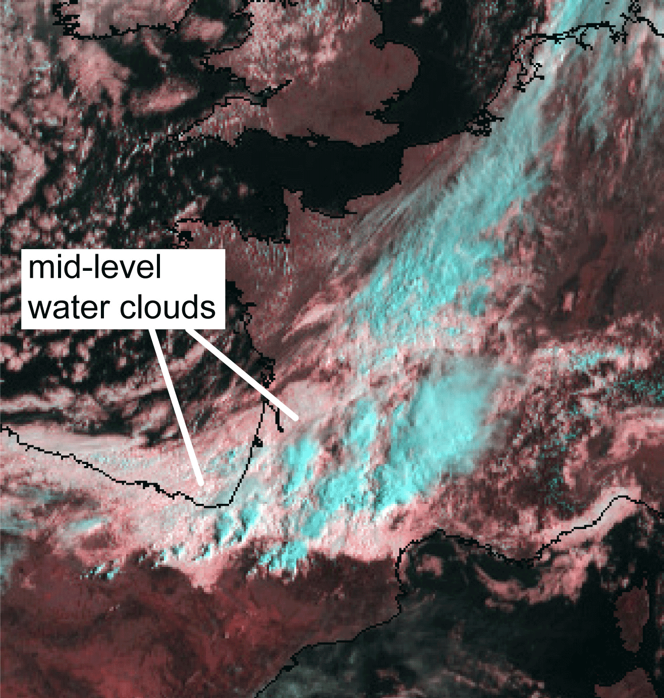
The satellite images, however, reveal the possible icing clouds. In the HRVFog combination the mid-level water clouds can be seen as light pinkish:
Fig. 5.22. HRVFog combination 14 May 2011 at 07.30 UTC.
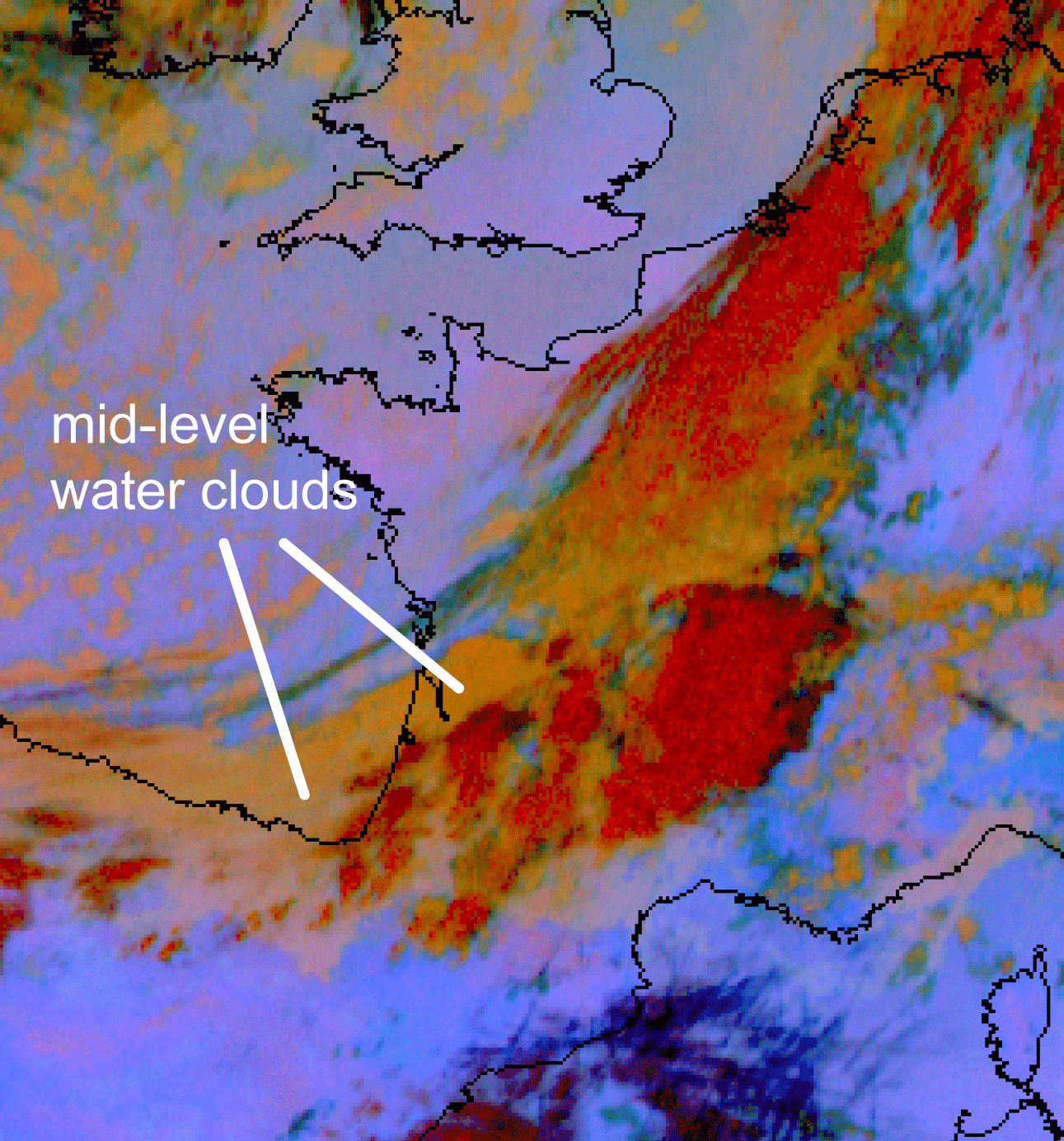
In the 24h Microphysical combination the water clouds are orange:
Fig. 5.23. 24hMicrophysical combination 14 May 2011 at 07.30 UTC
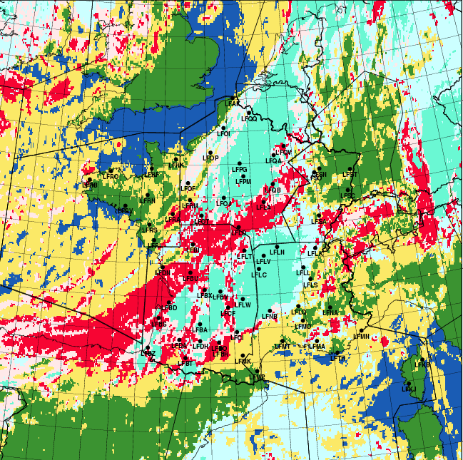
In Meteo France´s icing cloud product different meteosat images are converted into an interpretation where the possible icing clouds are revealed by excluding semi-transparent clouds, too cold or too warm clouds and ice-top clouds. The icing clouds appear red in the image:
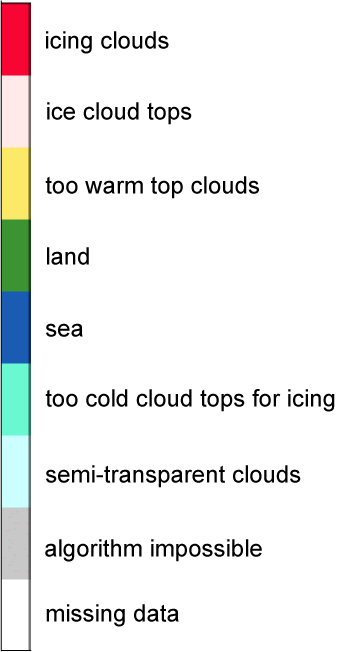
Fig. 5.24. ICLD product, 14 May 2011(by Christine Le Bot, Meteo France), with color scale
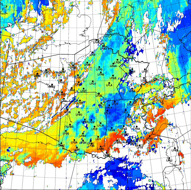
Another automatically interpreted product of Meteo France is the cloud top temperature, shown in Fig.5.25.b. The temperature scale is in Kelvin degrees. The icing clouds appear yellow-orange, which means temperature range 265…275 K or -8…+2 °C:
Fig. 5.25. TCLD product, 14 May 2011 (by Christine Le Bot, Meteo France), with color scale
