Chapter IV: Analysis of floodings by means of H-SAF
Table of Contents
- Chapter IV: Analysis of floodings by means of H-SAF
- Analysis of floodings by means of H-SAF
Analysis of floodings by means of H-SAF
As it was already mentioned in the previous chapters, the NWP models predicted the precipitation episode relatively well. The remote sensing data was very important for detailed monitoring and a great help to the meteorological and hydrological specialists during and after the event.
Introduction to H-SAF
In the last few years satellite products in the framework of H-SAF were also available for testing. All H-SAF products will be briefly presented in this part. In the following chapters more attention will be given to the specialized products which are more important for the 18 September 2010 floodings. At the time of the floodings in Slovenia and Croatia H-SAF was not yet fully operational, so some additional improvements from the last year are in progress.
The "EUMETSAT Satellite Application Facility on Support to Operational Hydrology and Water Management (H-SAF)" was established by the EUMETSAT Council on 3 July 2005, and kicked off on 16 September 2005. The development phase lasted for 5 years. Here are the main three branches of products:
- precipitation (liquid, solid, rate, accumulated);
- soil moisture (at large-scale, at local-scale, at surface, in the roots region);
- snow parameters (detection, cover, melting conditions, water equivalent);
More information on H-SAF activities can be found on the H-SAF web page: http://hsaf.meteoam.it/
Currently there are 13 types of products, six of which are precipitation from different satellite sources or NWP:
- PR-OBS-1 Precipitation rate at ground by MW conical scanners
- PR-OBS-2 Precipitation rate at ground by MW cross-track scanners
- PR-OBS-3 Precipitation rate at ground by GEO/IR supported by LEO/MW
- PR-OBS-4 Precipitation rate at ground by LEO/MW supported by GEO/IR
- PR-OBS-5 Accumulated precipitation at ground by blended MW and IR
- PR-ASS-1 Instantaneous and accumulated precipitation at ground computed by an NWP model
Three of them are soil moisture of different scale or depth:
- SM-OBS-1 Large scale surface soil moisture by radar scatterometer
- SM-OBS-2 Small scale surface soil moisture by radar scatterometer
- SM-ASS-1 Volumetric soil moisture (roots region) by scatterometer assimilation in NWP model
Snow products are important for flooding when there is a snow cover, especially in the mountains and when the temperatures are favourable for melting. Since this was not so in this case, these products will not be shown. Therefore, in the next two chapters only the precipitation and soil water products will be presented for the selected case.
Precipitation products
In H-SAF different precipitation products have different ground resolutions and different repetition periods and also a possible delay in delivery (Table 4.1).
| Product | Resolution (Europe) | Cycle (Europe) | Timeliness |
|---|---|---|---|
| Precipitation rate at ground by MW conical scanners (H-01) | 10 km (with CMIS) 15 km (with other GPM) | 6 h (with CMIS only 3 h (with full GPM)) | 15 min |
| Precipitation rate at ground by MW cross-track scanners (H-02) | 10 km | 6 h | 5 min |
| Precipitation rate at ground by GEO/IR supported by LEO/MW (H-05) | 8 km | 15 min | 5 min |
| Cumulated rain 3 and 24 h (H-05) | 10 km (for merged MW+IR) | 3 h | 15 min |
| Instantaneous and accumulated precipitation at ground computed by a NWP model (H-06) | 30 km, sampling 7 km | 3 h | 4 h |
Table 4.1: H-SAF precipitation products and their ground resolution, cycle and timeliness. Source H-SAF.
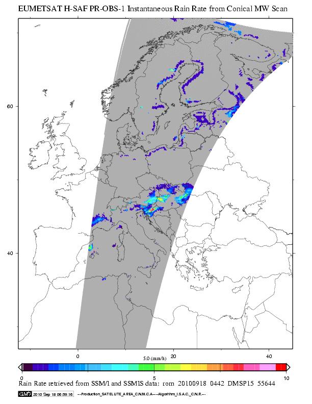
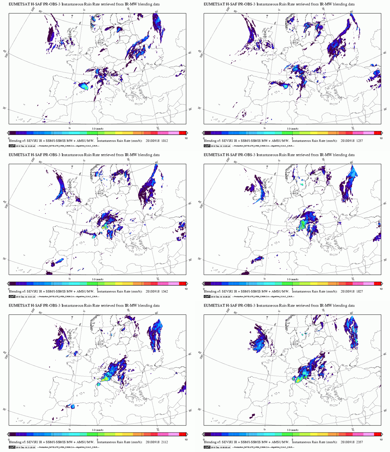
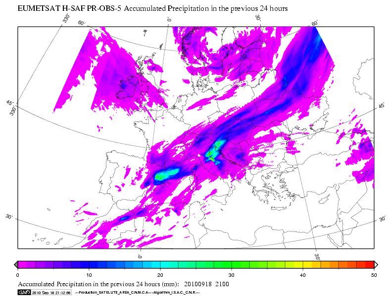
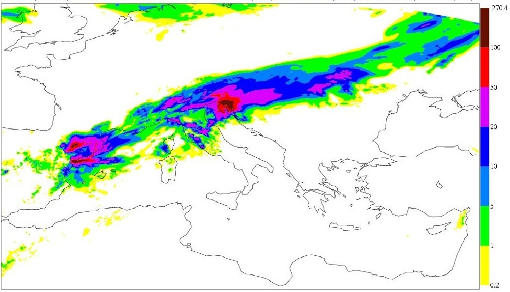
Below there are samples of H-SAF products for 18 September 2010. The precipitation based on satellite measurements in MW are a very important source of information (Fig. 4.1), but they are not very frequent, only being taken every 6 hours (see Table 4.1), so they need to be used in combination with other sources. On the other hand, the precipitation rate at the ground by GEO/IR supported by LEO/MW (H-03) is available every 15 minutes (Fig 4.2). When the accumulation of H-03 in the product H-05 was compared with the observation for 18 Sep 2010 (Fig 4.3), the accumulation amounts of H-05 were too low. On the other hand, H-06 (Fig 4.4) gave very comparable values to the ones measured at the ground.
Figure 4.1: Precipitation rate at the ground by MW conical scanners on 18 Sep 2010 at 04:42 UTC.
Figure 4.2: Precipitation rate at the ground by GEO/IR supported by LEO/MW, 18 September 2010 from 10:20 UTC to 23:50 UTC
Figure 4.3: Accumulated precipitation at the ground by blended MW and IR.
Figure 4.4: Instantaneous and accumulated precipitation at ground computed by a NWP model for the past 24h (mm) on 18 Sept 2010 at 21 UTC. Source EUMETSAT H-SAF.
Soil Moisture Products
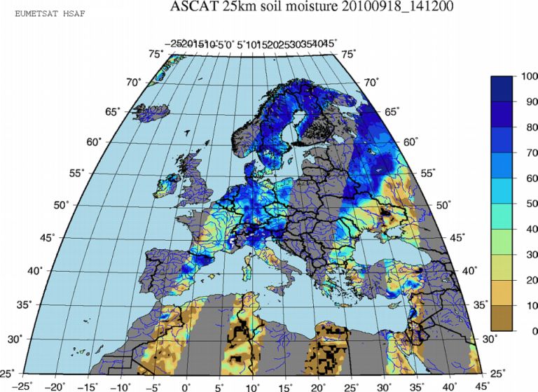
In addition to the precipitation field, one of the new products is soil moisture. Volumetric soil moisture was not available at that time, so large scale and small scale surface soil moistures are presented. Large scale surface soil moisture (SM-OBS-1) is retrieved by ASCAT measurements (Advanced SCATterometer) on board the METOP satellite. The basic ASCAT sampling distance is 12.5 km. The primary ASCAT observation, sea-surface wind, is processed at 50 km resolution. For soil moisture, processing is performed at 50 km (operational) and 25 km (research) resolution. The surface soil moisture product from scatterometers, which is based on the instrument predecessor AMI-SCAT on ERS-1/2, has been developed at the Vienna University of Technology (TU-Wien) for a long time. It was then modified for utilizing ASCAT (which has better resolution and sensitivity). The software has been integrated at the EUMETSAT Headquarters, and a “Global surface soil moisture” product is generated there and transmitted worldwide via EUMETCast. The coverage is extended to the whole globe. From that product, ZAMG extracts the orbital arcs intercepting the H-SAF area and generates SM-OBS-1. More information on SM-OBS-1 can be found here.
From Fig. 4.5 it can be seen that the soil water products show 90-100% surface soil moisture in Slovenia on 18 Sep 2010, which is a good result.
Figure 4.5: Large scale surface soil moisture by radar scatterometer for 18 Sep 2010.
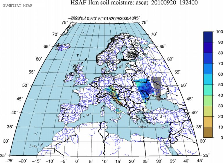
Product SM-OBS-2 (Small-scale surface soil moisture by radar scatterometer) results from the post-processing of the SM-OBS-1 product extracted by ZAMG from the Global surface soil moisture product distributed by EUMETSAT. For the purpose of SM-OBS-2, the 25-km resolution SM-OBS-1 product is disaggregated and re-sampled at 1-km intervals to better fit the hydrological requirements. The disaggregation process makes use of a fine-mesh layer that is pre-computed and stored in a parameter database. The fine-mesh information includes backscatter and scaling characteristics derived from SAR imagery from Envisat ASAR operating in the ScanSAR Global monitoring mode. More information on SM-OBS-2 can be found here.
The soil moisture looks reasonable on the large scale, but the 1 km small-scale moisture product does not add any significant information for Slovenia and Croatia (Fig. 4.6). One of the reasons can also be the very diverse orography. Perhaps disaggregation to a higher resolution would distinguish between valleys and mountains better. In this light the use of very high resolution satellite images below 1 km or even airplane measurements for the most important areas gives additional important information. See the example in section 5.
Figure 4.6: Small scale surface soil moisture by radar scatterometer for 20 Sep 2010.
Conclusions on use of H-SAF
The order of magnitude of accumulated precipitation for the case was correctly computed by the HSAF product H06 (instantaneous and accumulated precipitation at the ground computed by an NWP model), where satellite data in the assimilation process are included as well. On the other hand, precipitation accumulations from different satellite sources H05 (accumulated precipitation at the ground by blended MW and IR) were too low in this case, only up to 40 mm 24h (see Fig 4.4). The 24h accumulation H06 was muchbetter, from 100 to 270 mm, which fits the observations very well (see Fig 4.5).
The information on surface moisture on the large scale for 18 September correctly showed the high values over all Slovenia, which were already much lower on 20 September when the soil started to dry during the sunny day. The small scale data did not give additional information in this case, and cannot compete with high resolution data measured directly by satellite radars.
High Resolution Satellite Data
The International Charter on Space and Major Disasters is important protocol in such situations. The Slovenian local authorities applied this protocol during the event and the data obtained were processed by ZRC SAZU, SPACE-SI.
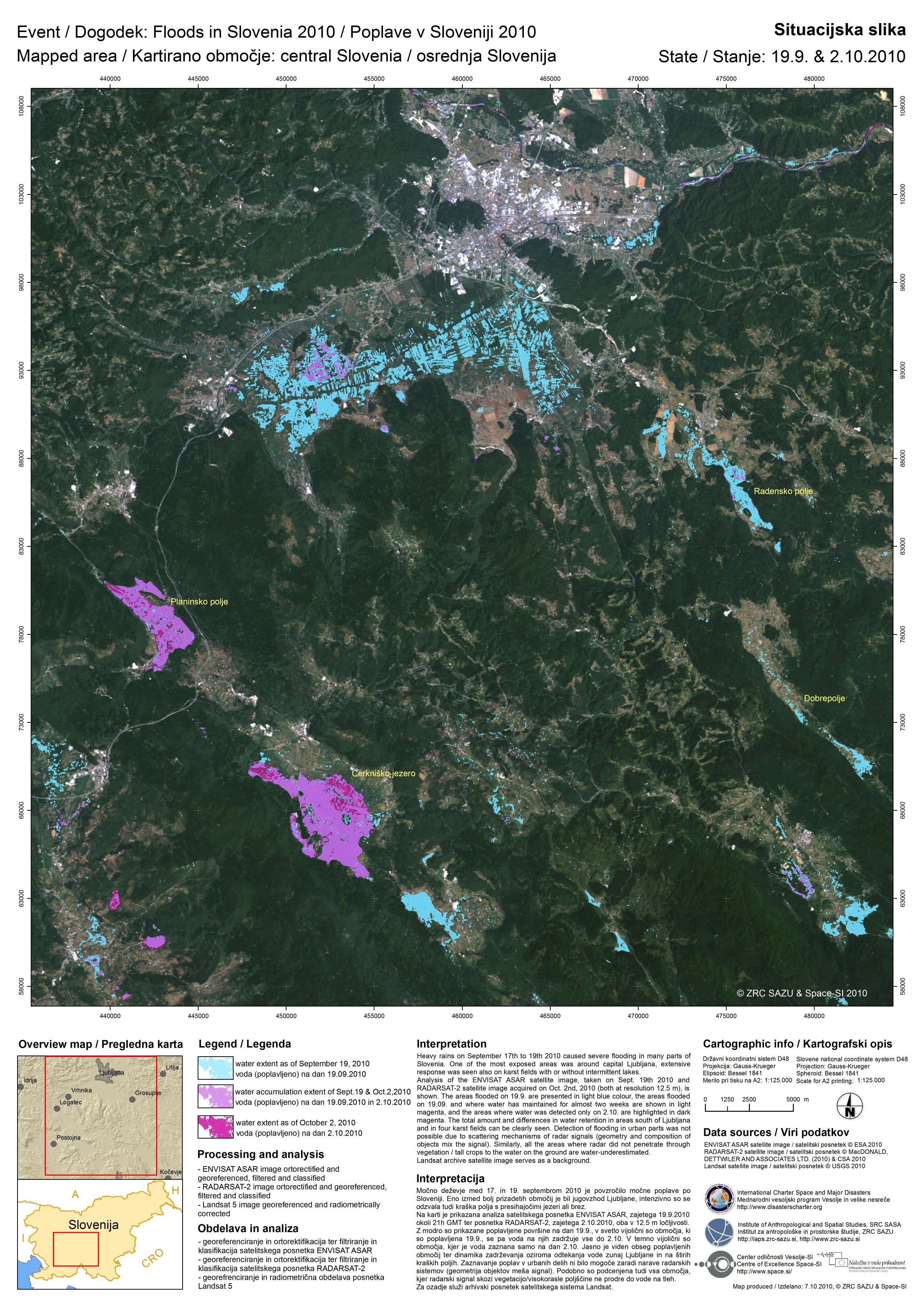
In Fig 4.7 there is an example of how Envisat ASAR, Radarsat-2 and Landsat 5 are processed by ZRC SAZU. Analysis of the ENVISAT ASAR and RADARSAT-2 satellite images (both at 12.5 m resolution), taken on 19 Sep 2010 and 2 Oct 2010, respectively, is shown. The areas flooded on 19 September are presented in light blue colour, the areas flooded on 19 September and where water remained for almost two weeks are shown in light magenta, and the areas where water was detected only on 2 October are highlighted in dark magenta. The total amount and differences in water retention in areas south of Ljubljana and in four karst fields can be seen clearly. Detection of flooding in urban parts was not possible due to the scattering mechanisms of radar signals. (The geometry and composition of objects distort the signal.) Similarly, all the areas where the radar did not penetrate through the vegetation / tall crops to the water on the ground give underestimated values for water content. A Landsat archive satellite image (© ZRC SAZU) serves as a background.
In this particular area of karst the specific phenomenon occurred that a few days after the precipitation some parts (which were not flooded on 19 Sep), were subsequently flooded since the underground caves were filled in and water also started to spread to the karst areas. This is also the reason that some areas were not flooded on 19 September, but were flooded on 2 October 2010.
Figure 4.7: Envisat ASAR, Radarsat-2, Landsat 5 prepared by ZRC SAZU
