Authors
ZAMGJarno Schipper
Introduction
June 19th 2006 proved to be a day with severe convection over most of Western and Central Europe. As an unstable airmass with shallow pressure tendencies slowly moves in from southwest. In the warm sector of former tropical storm "Alberto", which is moving from the Brithish Isles further northeast to Norway, numerous showers and thunderstorms develop as the insolation increases during the morning hours. There were numerous reports of hail reported associated to this convective event.

|

|
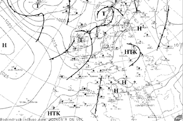
| Surface Analysis: 19th June 2006: 06 UTC |
Accumulated lightning activity: source wetterzentrale.de |
In the above two images the surface map and the lightning activity of 19th June are seen. Starting with the surface analysis a depression can be seen over the British Isles. This is former tropical storm Alberto, a was mentioned before. During the 19th June it slowly moves further northeast in the direction of Skandinavia. Further down east an upper level low (ULL) is denoted (indicated on the image by HTK). As the day sets and the insolation increases there is rapid grow of convection in the warm sector of the frontal system over Western Europe. In the course of this case study this convection in the warm sector will be further analysed with a range of numerical parameters both from ECMWF as well as the limited area model Aladin.
The second image shows the accumultated lightning reports of that day. Two areas with severe lightning are observed. One over Western Europe stretching from Spain and France into Central Europe with Germany, Switzerland and Austria. This region is where the where the emphasis of this case study will be about. Second, further to the east a second region with intensive lightning is observed that can be related to the activity of the ULL in the area. The stratospheric air is protuding downward in this area making the region less stable and more favourable for convective growth.
The aim of this case study is to:
- Study plain MSG satellite images as well as artificial coloured RGB combinations
- Study on how to relate satellite imagery with NWP
- Study and learn how to use a range of nowcating tools suchs as the NWC SAF, GII and INCA
To be able to follow the case study from the beginning it is preferable to study the chapters dealing with convection from the "Manual of Satellite Meteorology", and the powerpoints dealing with hazardous small scale weather from the "MSG Interpretation Guide" .