Authors
Vesa Nietosvaara - Finnish Meteorological Institute
Izolda Marcinoniene - Lithuanian Hydrometeorological Service
Introduction
The case study presents the synoptic analysis of an event that took place from the 9th to 11th August over the Baltic States and Finland. During this period both regions experienced heavy rain as a wave formed in moist and warm southeasterly air stream and further deepened into an cut-off low. Excessive rainfall was observed over large areas of Northeastern Europe.

|
|
| 9 August 2005/ 15 UTC - Meteosat-8 (6.2 Ám - 7.3 Ám) + (3.9 Ám - 10.8 Ám) + (1.6 Ám - 0.6 Ám) RGB "Convective Storms" combination image.
The cloud spiral SE of the Baltic States can clearly be seen in red-browsnish colours. An isolated MCS is about to develop over the Gulf of Finland; the light brownish centre of the MCS denote small ice particles at the top of the cloud, which is a sign of strong convection within the cloud. |
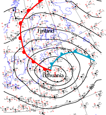
9 August 2005/ 12 UTC - A frontal analysis. Warm south-easterly air stream prevails in NE Europe; relatively high temperatures are observed in Finland and NW Russia. A cold front approaches from SE; the centre of the surface low is located over Lithuania at 12 UTC. Geographical locations of Finland and Lithuania shown. |
This study concentrates on two areas at the opposite sides of the low pressure area:
in Lithuania, on the SW flank of the low, the event was characterized by extreme rainfall (locally more than 250 mm in 3 days), leading to floods and severe damage to property. The south-westerly gusts on the 10th August caused uprooting of trees and further economical loss in excess of 45M euro.
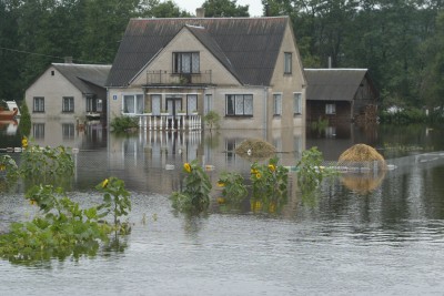 |
Village Jasiunai (near Vilnius) under flood, 11 August.
Photo: V. Kapocius |
In Finland, at the north-eastern part of the low pressure area, the most remarkable events were those connected with the passing of the cold front in the evening of August, 9, associated with the intensive precipitation and lightnings. These phenomena caused big difficulties in the timely conduct of IAAF World Championships of Athletes in Helsinki that evening.
Later on, since the low pressure center became almost stationary southwest of Finland, the rain bands associated with the occluded front spiral brought repeated showery rain.
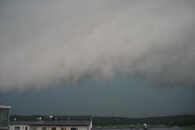 |
View to SE from Helsinki 9 August 15 UTC. Gust front approaches the city with fierce gusts, intensive rain and lightning.
Photo: Harri Hohti, FMI |
The objective of this case study is to illustrate the variablity of weather on opposites sides of an intensive summertime low pressure. We aim to give insight which are the synoptic ingredients for a strong summer convection within a cold front (Finland) and for a prolonged rain in within an occluded front (Lithuania).
The case study was presented as a poster presentation at Eumetsat Satellite Users Conference in Helsinki June 2006. The extended abstract can be downloaded here