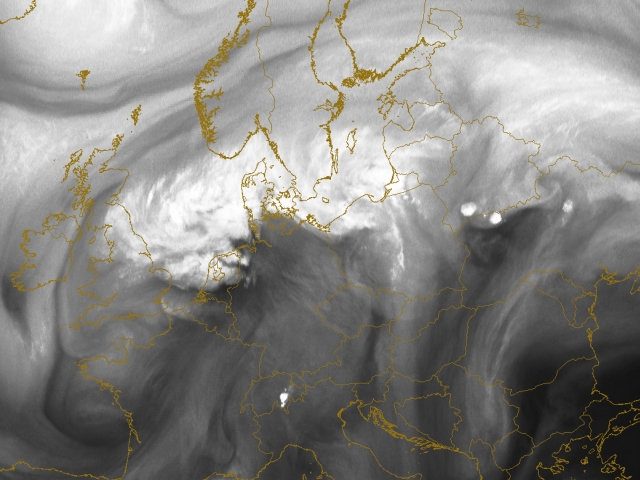
30th July 2005: 06UTC
The recognition of the frontal system over central Europe proves to be harder with WV6.2 imagery. The occluded part of the system is quite enhanced and appears as bright and white in WV over the Baltic Sea, Denmark and the North Sea.
Cyclonically curved over UK, the Gulf of Biscay into France and further to Belgium a dry band can be seen. On the tip of this dark band some increased convectivity is seen over the Netherlands. A deformation zone can be recognised over Spitsbergen and Skandinavia.
A bright cell is seen over Switzerland indicating some convective development that should be looked at in future timesteps. More interesting are the convective cells that have emerged over Belarus and Ukrain. They develop on a pronounced WV boundary.
30th July 2005: 07UTC
The Cb over Switzerland has shifted northward. On the tip of a WV dark stripe over Eastern Europe several cells develop (Ukraine/Belarus).
30th July 2005: 08UTC
Over Switzerland another Cb is seen. This not uncommon isolated early-moning convection is seen quite well in WV6.2 imagery and its development should looked at in following timesteps. More on this phenomena can be read here. Interesting are also the convective cells that have emerged over Belarus and Ukrain. They develop on a pronounced WV dark stripe.
30th July 2005: 09UTC
The Cb over Switzerland shifted northwards. On the tip of a WV dark stripe over Eastern Europe several cells develop (Ukrain/Belarus).
30th July 2005: 10UTC
Ahead of the frontal system also daytime convection is seen over the Ukrain.
30th July 2005: 11UTC
Again south of Switzerland a cell is observed. Future development into a larger cell may be expected.
Further east due to orographic lifting also over the Carpathian mountain convective cells have emerged.
30th July 2005: 12UTC
The convection over Northern Italy and Switzerland has increased. This development may be helped by orographic lifting by the Alps. More to the east also over Austria a small convective cell is recognised.
30th July 2005: 13UTC
Over Switzerland, Italy, Austria, Poland and Latvia signs of prefrontal convergence are seen. Small cells are recognised and their development should be studied also the following timesteps. Striking is all of these cells lie in the vicinity of WV boundaries!
30th July 2005: 14UTC
All of the previous discussed cells have further developed. From Lithuania southward over Poland into Austria, Switzerland over the Alps into Northern Italy a prefrontal convergence line is observed.
30th July 2005: 15UTC
All of the previous discussed cells have further developed. From Lithuania southward over Poland into Austria, Switzerland over the Alps into Northern Italy a prefrontal convergence line is observed. Within the cold front (north of the Alps; Bavaria) also indication of convective developments is seen.
30th July 2005: 16UTC
The line of convergence stretching from the Baltic States downward over Poland into the Alpine countries is still well visible. Within the cold front, situated over Bavaria and the Czech Republic, also cells have emerged over the the past hour.
30th July 2005: 17UTC
The line of convergence stretching from the Baltic States downward over Poland into the Alpine countries is still well visible. Also within the cold front part over Bavaria and the Czech Republic several thunderstorms are recognised.
30th July 2005: 18UTC
Over the Baltic States and Russia a large convective cell is observed. Southward over Lithuania, Poland, Austria a long line of prefrontal convergence is observed all the way up to Northern Italy. At this stage also within the cold front part over Bavaria and the Czech Republic several larger thunderstorms are recognised.
30th July 2005: 19UTC
Over the Baltic States and Russia a large convective cell is observed. Southward over Lithuania, Poland, Austria a long line of prefrontal convergence is observed.
At this stage also within the cold front part over Bavaria and the Czech Republic several larger thunderstorms are recognised.
30th July 2005: 20UTC
Embedded to the frontal system the large convective cell has moved into Russia. Southward a long line of prefrontal convergence is observed where several larger cells are recognised with south of them smaller cells. Also within the cold front part over the Czech Republic several thunderstorms are recognised.
30th July 2005: 21UTC
Over Russia a large MCS is observed. Further south the prefrontal convection cells have merged with the convective cells in the front forming a large cluster of convective cells covering Austria, Czech Republic and Poland. From the rear a WV dark stripe is approaching. Hampered by the Alps also a MCS is seen over Northern Italy.
30th July 2005: 22UTC
Russia is affected by a large MCS. Further south the prefrontal convection cells have merged with the convective cells in the front forming a MCS stretching from Austria into Northern Poland.
30th July 2005: 23UTC
A large MCS is observed over Russia. Further south the prefrontal convection cells have merged with the convective cells in the front. A large cell is observed over Eastern Austria and further south over Northern Italy. A cluster of convective cells is covering the Czech Republic and Poland.
31st July 2005: 00UTC
The MCSs seen previous over Russia and Belarus is dissolving. This can also be said on the convective system over Austria. At this stage one large convective cell over Poland is observed.
31st July 2005: 01UTC
Poland is covered by a large convective cell.
31st July 2005: 02UTC
The level of convection decreases.
31st July 2005: 03UTC
The level of convection decreases.
31st July 2005: 04UTC
The level of convection decreases.
31st July 2005: 05UTC
The level of convection decreases.
31st July 2005: 06UTC
In the aftermath of this case study convective cells are observed over Poland and Belarus. The size of this cell has however decreased significantly over night.