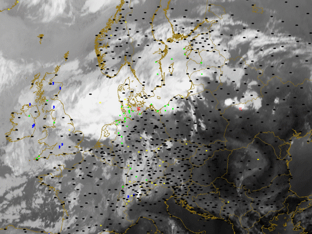
30th July 2005: 06UTC
With most of the occluded cloudband over sea (Baltic Sea and North Sea) observations are scarce. Over Sweden some rain is reported and further south over Northern Germany an isolated report of thunderstorm can be recognised. The cold front, consisting of low clouds, lies over Switzerland and Southern Germany and shows reports of rain and drizzle. Fog is found ahead of the cold front. This is the location where at later stage the convergence line will emerge. The fog is a sign for the available surface moisture.
30th July 2005: 09UTC
The frontal system is characterised by numerous reports of rain and drizzle. On the leading edge of the cold front fog is observed. This is the location where at later stage the convergence line will emerge. The fog is a sign for the available moisture on the surface.
30th July 2005: 12UTC
The frontal system is characterised by numerous reports of rain and drizzle. In Lithuania the first cells have emerged. They are marked by some reports of thunderstorms. Also further south on the windward side of the Alps in Northern Italy the first signs of prefrontal convergence are seen. This cell is confirmed by a report of thunder.
30th July 2005: 15UTC
A long prefrontal convergence line has developed. It consist of several individual cells that are found from the Baltic States over Poland towards Austria, Switzerland and Italy. They are superimposed by numerous reports of thunderstorms. Also further west in the cold front several cells are embedded with associated reports of thunderstorms.
30th July 2005: 18UTC
A long prefrontal convergence line still exists. It consist of several individual cells that are found from the Baltic States over Poland towards Austria, Switzerland and Italy. There are several reports of thunderstorms. More important however is the explosive development of thunderstorms within the cold front over Bavaria and the Czech Republic.
30th July 2005: 21UTC
A long prefrontal convergence can still be recognised but is decaying. So have the number of reports of thunderstorms along this line. Larger cells have developed within the cold front part of the system. Dozens of reports thunderstorms are seen in the Czech Republic and Poland. Also over the Baltic Staes a large MCS is still observed.
31st July 2005: 00UTC
Several weatheractive areas can be recognised. First up north over Belarus and Russia a MCS is recognised. Reports of rain and thunderstorms are seen. Also a large convective system is seen over Poland. The surface observation show thunderstorms and rain.
31st July 2005: 03UTC
The MCS over Poland is slowly decreasing in size and so does the level of convectivity. The reports of thunderstorms are also less.
31st July 2005: 06UTC
The MCS over Poland is slowly decreasing in size and so does the level of convectivity. The reports of thunderstorms are also less.