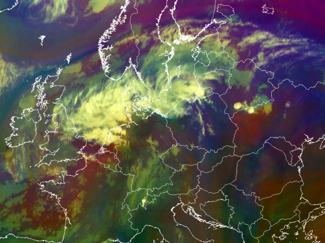
30th July 2005: 06UTC
The frontal system covering central Europe is easier to recognise with these set of airmass images. The occlusion with some convective cells embedded, is found over Poland, Germany and the Netherlands. Further to the south the cold front is recognised as the low level cloudiness pictured in blue covering Eastern France and Switzerland. On the cyclonic as well on the anticlyclonic side of the frontal system two areas of deepening (pictured here as purple) is recognised. Most convection will start on the boundaries of these WV features. Further east, ahead of the frontal system on the border between Belarus and Ukraine an area with high PV values is recognised (appears as red). The cyclogenesis observed here is accompanied by convection as some cells emerged.
Note. You can always click on the to bring up the RGB-key.
30th July 2005: 07UTC
Ahead of the frontal system on the border between Belarus and Ukraine an area with high PV values is recognised (appears as red). The cyclogenesis observed here is accompanied by convection as some cells have emerged. The cold front part has shifted eastwards. Embedded to the cold front an isolated Cb is seen over the Swiss Alps.
30th July 2005: 08UTC
Ahead of the frontal system on the border between Belarus and Ukraine an area with high PV values is recognised (appears as red). The cyclogenesis observed here is accompanied by convection as some cells have emerged. The cold front part has shifted eastwards. Embedded to the cold front an isolated Cb is seen over the Swiss Alps.
30th July 2005: 09UTC
Ahead of the frontal system on the border between Belarus and Ukraine an area with high PV values is recognised (appears as red). The cyclogenesis observed here is accompanied by convection as some cells have emerged. The cold front part has shifted eastwards. Embedded to the cold front an isolated Cb is seen over the Swiss Alps.
30th July 2005: 10UTC
Ahead of the frontal system on the border between Belarus and Ukraine an area with high PV values is recognised (appears as red). The cyclogenesis observed here is accompanied by convection as some cells have emerged. The cold front part has shifted eastwards. Embedded to the cold front an isolated Cb is seen over the Swiss Alps.
30th July 2005: 11UTC
Over Northern Italy on the windward side of the Swiss Alps some more onset to convection is seen. It may be triggered by orographic lifting since no red stripes, e.g. cyclogenesis is involved/observed.
30th July 2005: 12UTC
The small cell south of the Alps has further developed and can now be seen over Liechtenstein. Furthermore, over Austria and Poland also the first signs of prefrontal convergence are seen as small cells are recognised and should be looked at in following timesteps. The convection to the east over the Carpathians has continued.
30th July 2005: 13UTC
The convection previously discussed over Austria has continued. A large convective cells is recognised over the Alps. Also more to the west over Switzerland several other convective cells are recognised. Further north over Eastern Poland a young cell is recognised. More striking is that all of these cells develop on WV boundaries (appears here as purple).
30th July 2005: 14UTC
The convection previously discussed over Austria has continued. A large convective cell is recognised over the Alps. Also more to the west over Switzerland several other convective cells are recognised. Further north over Poland also cells have emerged. A prefrontal convergence line has formed. More striking is that all of these cells develop on WV boundaries (appears here as purple).
30th July 2005: 15UTC
Over Latvia a large convective cell is observed. Southward a long line of prefrontal convergence is observed all the way up to northern Italy. Still under influence of daytime convection and a high pressure system (anticyclonic movement is well observed in the satellite images) in Eastern Europe also convective systems are recognised.
30th July 2005: 16UTC
Over Latvia and Estonia a large convective cell is observed. Southward a long line of prefrontal convergence is observed all the way up to northern Italy. Striking is that all of these cells develop on WV boundaries (appears here as purple). Within the cold front which is situated over Bavarie and the Czech Republic also convection has started.
30th July 2005: 17UTC
Over Latvia and Estonia a large convective cell is observed. Southward a long line of prefrontal convergence is observed all the way up to northern Italy. Striking is that all of these cells develop on WV boundaries (appears here as purple). Within the cold front which is situated over Bavarie and the Czech Republic also convection has started. Clustered Cbs are observed.
30th July 2005: 18UTC
Over the Baltic Sates and Russia a large convective cell is observed. Southward a long line of prefrontal convergence is recognised. Within the cold front part over Bavaria and the Czech Republic several thunderstorms are recognised. The area is marked by several Cbs.
30th July 2005: 19UTC
Over the Baltic Sates and Russia a large convective cell is observed. Southward a long line of prefrontal convergence is recognisedWithin the cold front part over Bavaria and the Czech Republic several thunderstorms are recognised. The area is marked by several Cbs which are merging together at this stage.
30th July 2005: 20UTC
The large convective cell has moved into Russia. Southward a long line of prefrontal convergence is observed all the way up to northern Italy. Striking is that all of these cells develop on WV boundaries (appears here as purple).
Most of the cells that developed within the cold front band have merged forming one big MCS over the Czech Republic.
30th July 2005: 21UTC
Russia and Belarus are affected by a large MCS. Further south the prefrontal convection cells start to merged with the convective cells in the front forming a large cluster of convective cells covering Austria, Czech Republic and Poland. Hampered by the Alps also a MCS is seen over Northern Italy.
30th July 2005: 22UTC
Russia and Belarus are affected by large MCSs. Further south the prefrontal convection cells have merged with the convective cells in the front forming a large cluster of convective cells covering Austria, Czech Republic and Poland.
30th July 2005: 23UTC
Russia and Belarus are affected by large MCSs. Further south the prefrontal convection cells have merged with the convective cells in the front forming a large cluster of convective cells covering the Czech Republic and Poland. The large cell seen over Austria is slowly dying out.
31st July 2005: 00UTC
Russia and Belarus are affected by large MCSs. Further south the prefrontal convection cells have merged with the convective cells in the front forming a large cluster of convective cells covering Poland. The large cell seen over Austria is slowly dying out.
31st July 2005: 01UTC
The level of convectivity has diminished in appearance over Russia. Further to the southwest Poland is still covered by a large convective cell. It is accompanied by a WV red stripe on the anticyclonic side.
31st July 2005: 02UTC
The level of convectivity has diminished in appearance over Russia. Further to the southwest Poland is still covered by a large convective cell. It is accompanied by a WV red stripe on the anticyclonic side.
31st July 2005: 03UTC
The level of convectivity has diminished in appearance over Russia. Further to the southwest Poland is still covered by a large convective cell.
31st July 2005: 04UTC
Over Poland a large convective cell is observed embedded into the frontal system. It is accompanied by a WV red stripe
31st July 2005: 05UTC
Over Poland a large convective cell is observed embedded into the frontal system. It is accompanied by a WV red stripe.
31st July 2005: 06UTC
In the aftermath of this case study a convective cell is observed over Poland and Belarus. The size of this cell has however decreased over the past hour.