Personal Data

In the next web page you will be requested to provide your identifying information (email address – the only mandatory one, name, surname and company name). The purpose of collecting this is to:


Your personal data will be processed and retained only for the purpose for which it was collected. Personal data will not be published, sold or made available for general access or to third parties. You may request to have your data corrected and updated, or if possible, deleted.


Should you have questions regarding the use of your personal data, please contact info@eumetrain.org or tso@eumetrain.org.


The Training Bulletin

Joint newsletter related to new activities and resources
in European meteorological training

// issue XXXVI - April 2026

Activities & events
//image missing//

EUMeTrain Forest Fires online event week – Save the date!

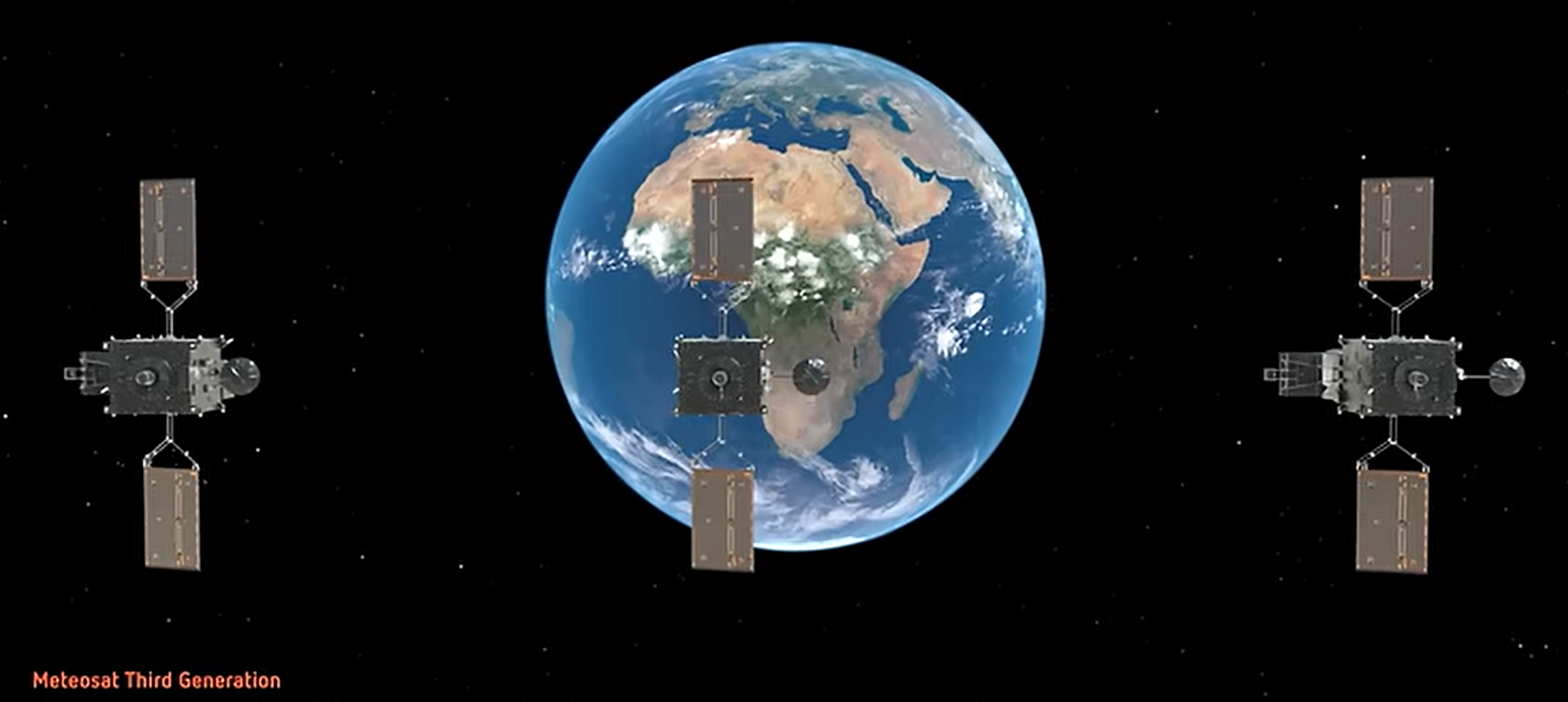
1 – 3 June 2026 / Online | EUMeTrain web page

Between 1st and 3rd June 2026, EUMeTrain will be organising a satellite training event week on Forest Fires. In this event, you will be able to know more about the most recent developments on forest fire monitoring with satellite data, namely from the Flexible Combined Imager(FCI) and Lightning Imager (LI) on-board the Meteosat Third Generation satellite.


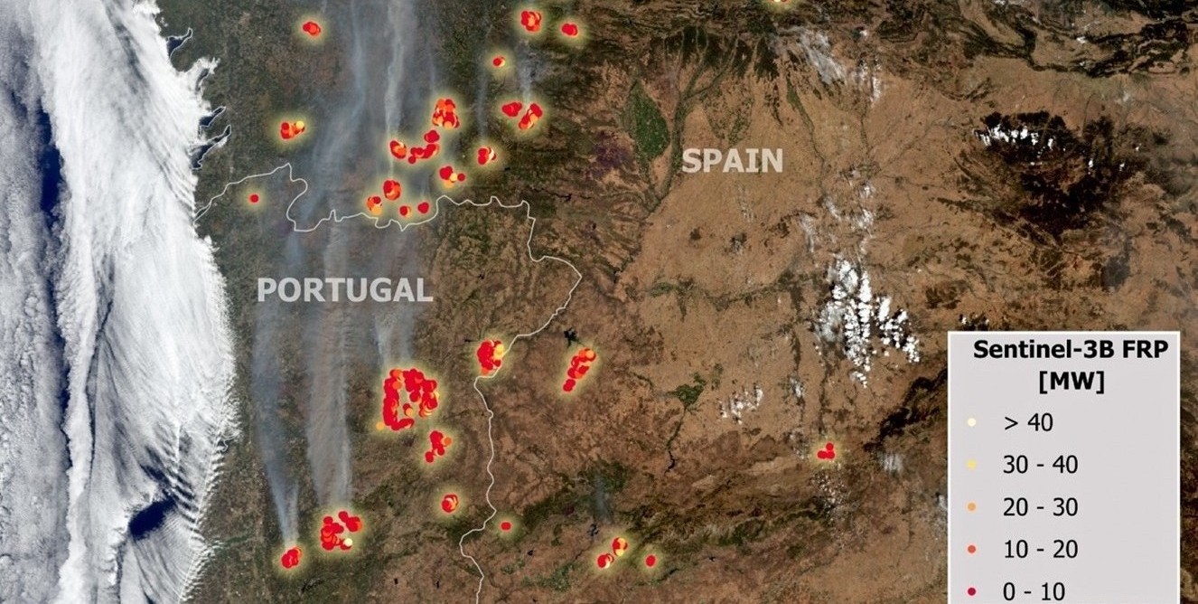
During the week, there will be both plenary sessions on more in-depth topics, as well as show casing sessions on more specific applications. The sessions will address the whole life cycle regarding forest fires, such as vegetation status and forest fire risk, hots-spots and fire smoke detection, and burnt area monitoring.


For more details, stay tuned on the EUMeTrain webpage, where the full agenda of the event will be released shortly on www.eumetrain.org.

//image missing//

8th Joint Training on Atmospheric Composition

19 – 23 October / Thessaloniki, Greece

Registration is now open for the Eighth Joint Training Course on Atmospheric Composition, organised by the European Space Agency (ESA), the European Organisation for the Exploitation of Meteorological Satellites (EUMETSAT), and the European Centre for Medium-Range Weather Forecasts (ECMWF), with the support of the Copernicus Atmosphere Monitoring Service (CAMS). The course will take place from 19 to 23 October 2026 and will provide advanced training on atmospheric composition monitoring and modelling using satellite observations and numerical services.


The training will be delivered in a hybrid format, combining online preparatory lectures with four-and-a-half days of in-person sessions, hosted by the Laboratory of Atmospheric Physics, School of Physics, Faculty of Sciences, Aristotle University of Thessaloniki, Greece. The programme will cover theoretical aspects and practical applications, offering participants the opportunity to work directly with operational data, products, and tools used within the Copernicus and European meteorological satellite framework.


The course is intended for PhD students, early-career scientists, researchers from academia and research institutes, industry professionals, and anyone interested in atmospheric composition. On-site participation is limited and selection is competitive, with priority given to applicants from ESA, EUMETSAT, and ECMWF Member States, although applications from all countries are welcome. Online lectures will be accessible to a wider audience.


Register.

//image missing//

International Summer School on Applications with the Newest Multi-spectral Environmental Satellites

9 – 18 June 2026 / Bracciano, Italy

This Summer School offers an in-depth exploration of remote sensing methods and techniques used to extract information from environmental satellite data, with a strong focus on the latest observing technologies, particularly the Meteosat Third Generation (MTG) mission.


Designed for experienced professionals, the course combines theoretical lectures with hands-on practical sessions, allowing participants to apply concepts using tools such as McIDAS-V or similar data processing and visualisation software. The programme provides a comprehensive overview of modern remote sensing applications, supporting participants in strengthening their technical understanding and practical skills.


The training is tailored for forecasters, researchers, and postgraduate students working with environmental satellite data, who wish to update their knowledge and stay aligned with the latest developments in the field. Participants will engage with expert instructors, and benefit from an interactive learning environment that encourages discussion and exchange of experience.


Applicants are expected to have a relevant academic background in meteorology, physics, environmental sciences, or environmental engineering.


Applications are based on the nominations by the heads of delegations of EUMETSAT members. Nominated candidates can apply at Eumetsat Classroom.

//image missing//

Join the EUMETCAL Winter Weather Hackathon

7 – 11 September 2026 / Norrköping, Sweden

If you work with winter weather — forecasting it, researching it, or teaching it — you know how complex these phenomena can be. Translating that expertise into clear and practical training for forecasters is an equally demanding task.


The upcoming EUMETCAL Hackathon on Winter Weather offers the opportunity to tackle that challenge, together with colleagues across the community.

From 7–11 September 2026, forecasters, researchers, trainers and instructional designers will meet at SMHI in Norrköping, Sweden, to collaboratively develop online learning modules on winter weather topics. These may include freezing rain, snow, icing, lake and sea effects, road winter weather, or other winter weather topics that are relevant to you.


The hackathon format has already proven its value. Previous EUMETCAL hackathons resulted in highly interactive training modules on topics such as radar meteorology, satellite meteorology, optical phenomena, mountain waves, and impact-based forecasting. These resources are now published and used across the community to support the training of new and experienced forecasters.


By joining the hackathon, you will contribute your expertise to the development of new learning materials, while experiencing a collaborative and creative approach to course design. The result: practical training resources that benefit the entire forecasting community.


If you would like to help shape the next generation of winter weather training, we invite you to take part. More detailed information can be found in the in the invitation.


//image missing//

Advanced Satellite Course 2026: Focus on MTG, NWP and Weather Forecasting

16 November – 11 December 2026 / HYBRID

The Advanced Satellite Course 2026 (ASC 2026) is a blended training program designed for experienced forecasters in aviation or general meteorology. It runs from 16th November to 11th December 2026, with an online phase from 16th November to 4th December followed by a final classroom phase from 7th December to 11th December at the DWD Campus in Offenbach am Main.


The course focuses on deepening specialist knowledge of satellite meteorology, particularly the use of Meteosat Third Generation (MTG) imagery and products in combination with numerical weather prediction (NWP) and other meteorological data.


Key subject areas include weather phenomena over the Mediterranean, the westerly wind zone, and Northern Europe, with case studies on wild fires, Storm Amy, and polar lows. Participants will engage in three hours of online work per week, including brief playground sessions, and will attend a four‑day in‑person block to consolidate learning. Learning objectives are to enhance satellite meteorology expertise, improve practical application of MTG data in operational forecasting, and exchange of working methods across weather services.


Prerequisites are basic synoptic meteorology, hands‑on forecasting experience, and familiarity with MTG images; technical equipment is not mandatory, though bringing a notebook or tablet is advisable.


The invitation letter will be published in April with a deadline of 26th June 2026. For all information follow the EUMeTrain website.

//image missing//

High Impact Weather webinars

7 April 2026 and 4 May 2026 / Online

The HIW EUMETCAL online course will focus on the use of a particular forecasting method based on Doswell’s ingredient-based forecasting method IBM (1996). This method assumes that three ingredients are needed for convection: moisture, lift, instability (and vertical wind shear to take the modes in convection into account).


These convection modes each have their own distinctive characteristics in relation to duration, radar images and hazardous weather phenomena, such as lightning, wind gusts, hail, and heavy precipitation. This method has been incorporated into a convection scheme that is currently used at the KNMI forecasting office. It leads, via a few steps, to one of four convection modes. The course will explain the method and describe several typically synoptic situations that regularly yield severe convection.


You can find more information at the EUMETCAL Portal.


As a part of this course, Rob Groenland (KNMI) will present two webinars:


  1. High Impact Weather webinar 1: 7 Apr 2026 09:00 UTC (11:00 CEST)
  2. High Impact Weather webinar 2: 4 May 2026 09:00 UTC (11:00 CEST)

Recordings and slides from webinars will be available in the course environment.


//image missing//

Convection Working Group and 3T Forum meeting in October

19 – 23 October 2026 / Alcalá de Henares, Spain

The next Convection Working Group (CWG) meeting, jointly organised with the Expert Forum for Preparing Meteorological Applications and Training (3T Forum), will be held 19-23 October 2026, in Alcalá de Henares, Spain.


In recent years, convection monitoring through satellites has seen big improvements, through the capabilities the new satellites and instruments provide us. The meeting in Spain will provide an opportunity to gather and exchange the latest progress in research and operations for convection monitoring.


The week will consist of presentations, discussions, and application demonstrations. The meeting venue at Colegio de San Ildefonso of the University of Alcalá should provide a conducive environment for the meeting.


The Convection Working Group consists of 100 remote sensing and forecasting experts on convection.


More information of the group can be found at the CWG website.

//image missing//

FMI-EUMETSAT Aviation Forecaster Testbeds 2026

2 – 6 November 2026 / EUMETSAT, Darmstadt, Germany

In partnership with the Finnish Meteorological Institute (FMI), EUMETSAT will offer the second Aviation Testbed of 2026, aimed at preparing aviation forecasters for the operational use of Meteosat Third Generation (MTG) data and products. Aviation Testbeds simulate a real-time forecasting environment, enabling participants to further develop their skills in applying advanced satellite information in aviation services.


Delivered through FMI’s GEOWEB platform, the training provides access to a comprehensive range of meteorological data, including models and observations, with particular emphasis on satellite-based products such as icing potential, fog and low clouds, visibility, turbulence, volcanic ash, and lightning.


The programme integrates theoretical input with hands-on forecasting activities. Participants will work through selected case studies, generating forecasts and nowcasts using modern tools, followed by verification and interactive discussion sessions. A key focus will be on the use of MTG-I1 Flexible Combined Imager(FCI) and Lightning Imager (LI) data and products.


Applications to this course are based on the nominations by the heads of delegations of EUMETSAT members.


Nominated candidates can apply at Eumetsat Classroom.


// issue XXXVI - April 2026

Resources & Tools
//image missing//

New guide on fire detection, monitoring and assessment

Online

EUMETSAT has released a new application guide dedicated to fire management, providing a resource to support the selection, and use, of satellite data for fire-related analysis. The guide aims to facilitate access to relevant products, simplifying the identification of suitable datasets for different application. It presents the tools required for fire detection, monitoring, and assessment, covering pre-fire risk evaluation, ongoing event monitoring, and post-fire impact analysis.


Fires are among the most dynamic and widespread phenomena observed on Earth, occurring in natural vegetation, agricultural areas, and industrial contexts. Copernicus satellites play a fundamental role in detecting, monitoring, and assessing these events by delivering consistent observations of thermal radiation, smoke, and surface changes across regional to global scales. These measurements support key activities such as early detection, tracking of fire evolution, estimation of fire intensity, monitoring of emissions, and evaluation of environmental consequences.


The guide introduces typical use cases for Earth observation (EO)–based fire monitoring and provides an overview of the satellite missions, data products, and access services available through EUMETSAT and partners. By bringing all essential information together in a single reference, the guide supports a more efficient use of EO data for operational applications, scientific studies, and environmental assessments related to fire management.


Read the Satellite data for fire management guide.


//image missing//

How to recognise an Atmospheric River

Online

Have you ever wondered what an Atmospheric River is, or how to recognise it in model or satellite data? This new training module will assist you with a step-by-step guide of the identification process.


First, you will learn some basic facts on Atmospheric Rivers; how and where they are created, their typical characteristics, and their appearance in satellite and model data. You will then be guided through the identification process until you are certain that you are dealing with the phenomenon that is called an Atmospheric River.


Later stages of Atmospheric Rivers are sometimes tricky to identify as they are often merged with mid-latitude frontal systems. However, model fields and the timely evolution can give a precise answer whether there is an embedded AR or not.

Going through this training module is particularly useful for meteorologists, as ARs are responsible for many floods and heavy precipitation in Western Europe, once they make landfall.


Access the training module on Atmospheric Rivers.

//image missing//

EUMETCAL/EUMeTrain training modules on Sea-Surface Wind Data and Sea-State Data

Online

The EUMETCAL/EUMeTrain Basic Satellite Course has two new available chapters on wind and waves under the module on EUMETCAL/EUMeTrain training modules on Sea-Surface Wind Data and Sea-State Data. These chapters are aligned with the WMO competency framework on satellite skills and knowledge for operational meteorologists.


The first chapter aims focuses on the interpretation of sea-surface wind data. By the end of the chapter, students should be able to use scatterometer sea-surface wind data, recognisze wind patterns of fronts, cyclones, and local winds, and be aware of the limitations of scatterometer sea-surface wind measurements, including wind direction ambiguities, wind speed inaccuracies, and rain effects.


The second chapter focuses on the interpretation of sea-state data. After completion, students should be able to analyse and monitor ocean surface waves using altimetry data, understand how altimeters estimate wave height, comprehend and benefit of multi-satellite approach in sea state monitoring and forecasts, and be aware of altimeter data limitations.


Access the module on sea-surface wind data and sea-state data here.

//image missing//

New learning module on Challenges of Using Geostationary Satellite Data in High-Latitude regions

Online

The training module shows the unique challenges that forecasters face when using satellite imagery in high‑latitude regions. Using a variety of examples and exercises, it compares different types of satellites (geostationary and polar‑orbiting) and different generations of satellites, as well as the benefits and drawbacks of each. It also explains different phenomena that occur in these high‑latitude regions due to viewing geometry, among other factors.


Access the training module.


//image missing//

Short courses on fire and dust – recordings available

From November 2025 to March 2026 / Online

The EUMETSAT’s Atmospheric Composition training team has recently organised a series of short courses dedicated to fire and dust applications, with a strong component of Copernicus data. These courses were designed to support users in accessing and utilising EUMETSAT resources for fire and dust monitoring and analysis.


Participants explored a range of satellite data products, including Sentinel-3 NRT FRP, Sentinel-3 NRT AOD, MTG Fire Temperature, IASI DOD etc, gaining information on their usage. The courses combined theoretical background with practical demonstrations, introducing visualisation and analysis tools, such as EUMETView, as well as more advanced workflows using Jupyter Notebooks, for users interested in deeper data exploration and processing.


All training materials, including session recordings and presentation slides, are freely available and accessible via the links below. These resources are intended to provide continued support beyond the live sessions.


  1. Fires in the Iberian Peninsula
  2. Using EUMETView to depict dust events
  3. Introduction to Fire products - Beginners/Intermediate

//image missing//

New Data Store Notification service enables automated near real-time data delivery

Online

EUMETSAT launched a notification pilot service for the Data Store, enabling real-time alerts when new products become available. This MQTT-based system eliminates manual catalogue monitoring by providing automated notifications directly to users.


The service integrates seamlessly with EUMETSAT Data Access Client (EUMDAC) 3.1.0 , allowing users to create configurable subscriptions with filtering criteria, including region of interest and orbit parameters. When matching products are detected, the system automatically downloads them to user-defined local storage locations.


Key advantages over traditional methods include immediate product availability updates, automated download functionality, and customisable filtering through Data Tailor integration. Users can access live feeds from any Data Store collection using simple commands like: eumdac livefeed -c EO:EUM:DAT:MSG:HRSEVIRI.


This service saves operational time by replacing periodic manual checks with real-time automated monitoring, particularly valuable for time-sensitive applications requiring the latest satellite data.


To get started with the notification service, complete documentation is available in the Data Store User Guide. Read the service announcement.


For any support, contact the EUMETSAT User Helpdesk at ops@eumetsat.int.

//image missing//

Learn OSI SAF Sea Ice notebook updated

February 2026 / Online

In mid-February 2026, a major update of OSI SAF Sea Ice Jupyter Notebooks was released. The code demonstrated now considers the latest project evolution and has additional explanations. Two uses case show how to display sea-ice concentration anomalies, and how to display the Sea Ice Index data in a spiral.


Go to the Jupyter Notebooks.


//image missing//

New features in the EUMETSAT User Portal

Online

A new version of the EUMETSAT User Portal has been released, which provides users with extra functionality.


This new version allows users, via log in, to customise their own dashboard, so they can add their favourite content within the dynamic components on the homepage.


Other recent updates:


  1. New content type Open learning, providing access to self-paced learning courses.
  2. Separation of Software and Jupyter Notebooks content types, for ease of search.
  3. Layout improvements to data collections and events.

To get familiar with using the custom dashboard portal, check out the Exploring the user portal guide or watch the video on customising the UP dashboard.


For more information, contact the User Service Helpdesk.

// issue XXXVI - April 2026

Stories & Achievements
//image missing//

3T Forum group marks 50th session, reflects and looks ahead

Monthly basis / Online

The 50th session of the 3T Forum group marked an important milestone and an opportunity to reflect on the evolution of this community of practice. Established in 2020 and facilitated by Ivan Smiljanic at EUMETSAT to support users navigating new satellite missions, the forum has grown into a network of more than 100 experts engaged in regular knowledge exchange and collaborative problem-solving.


A short participant survey confirmed that the group continues to deliver high value, particularly through access to expertise, practical insight sharing, and coordination across institutions.


Looking ahead, the focus will be on enhancing visibility, strengthening knowledge capture, and broadening participation. Experts across the community are invited to join and contribute to the next chapter of the 3T group by emailing training@eumetsat.int.

//image missing//

Concluding the 2026 Supporting Marine EO Applications course

23 February – 20 March 2026 / Online

The 2026 edition of the EUMETSAT Supporting Marine Earth Observation Applications (SMA) online course concluded on 20 March. The course brought together oceanographers, remote sensing scientists, and application developers to explore effective use of marine data from our Copernicus and mandatory missions.


Across the self-paced and virtual classroom phases, 35 participants developed self-defined ‘mini projects’ aligned with their interests. Project development was supported throughout by expert trainers in ocean colour, altimetry, sea surface temperature, wind, and sea ice, with support from the EUMETSAT Copernicus Marine Training Service, EUMETSAT OSI SAF, and the Deutsches Geodätisches ForschungsInstitut (DGFI) at the Technical University of Munich.


This year’s projects included applications for jellyfish bloom monitoring, renewable energy siting, development of regional ocean colour products for fisheries and aquaculture, along-track and swath altimetry comparisons, pan-sensor monitoring of mesoscale eddies, and workflows for marine spatial planning.


All projects were built on the resources available on EUMETLAB, EUMETSAT’s open-source Python-based Jupyter Notebook library, freely available for both local and cloud use. We encourage you to explore what's available. If you’re interested in working with our marine data or tools, we’d be happy to hear from you. The SMA course will return in early 2027. We hope you’ll join us!

//image missing//

Web-based RTTOV at the NWP SAF satellite data assimilation training course

23 – 27 March 2026 / ECMWF, Reading, UK

The Web Based Satellite Sounding Training Application (WeSS4T) was used to teach around 30 delegates about radiative transfer (RT) and retrievals at the annual NWP SAF satellite DA course in ECWMF this year.


The tool uses the fast RT model RTTOV at its core and has undergone significant development at Météo France to make it more robust for intensive calculations, such as calculating spectra and Jacobians for hyperspectral instruments like IASI, IASI-NG and MTG-IRS. The tool was well received and provided a hands-on RT experience, which was particularly useful for those new to the topic. The user can change variables such as satellite instrument, atmospheric profile, surface emissivity, satellite zenith angle, and even add increments to parts of the atmosphere to get a feel for the response in channel radiances. The IDVAR capability made the retrieval process more accessible by allowing the user to change noise, observation, and background errors, effectively putting the data assimilation of satellite observations in their hands.


There are plans to add more diverse instruments that will be part of upcoming missions, such as the sub-millimetre Ice Cloud Imager (ICI) on Metop-SG B, in time for the next training course.


Try it for yourself at the following link - https://sounding.trainhub.eumetsat.int

//image missing//

Atmospheric Composition training on fire, at a WEkEO event

24 – 26 February 2026 / Online

The recent workshop on natural disasters was very successful, attracting a lot of interest from users and experts working in the field of natural hazard monitoring. Within this event, EUMETSAT and the Atmospheric Composition training team contributed with two short, dedicated training sessions focused on fire applications using Copernicus data.


The first session introduced the theoretical background of fire detection from space, explaining how satellite observations can be used to identify fire hotspots and monitor smoke dispersion. The second session provided a practical perspective, guiding participants on using Jupyter Notebooks within the WEkEO environment to access, process, and analyse data.


The Atmospheric Composition sessions can be found in the following videos:


  1. Theory: https://www.youtube.com/watch?v=acGaXPheNyA&list=PLAT-b7DuvMgrvKzdqxj1aj81KfAB3gDGQ&index=4 (min 29)
  2. Practice: https://www.youtube.com/watch?v=sWuEDUpDnZQ&list=PLAT-b7DuvMgrvKzdqxj1aj81KfAB3gDGQ&index=6 (min 8)

Jupyter Notebooks with direct access to the WEkEO data catalogue are available.

// issue XXXVI - April 2026

Jobs & Opportunities
//image missing//

VN 26/15 User Engagement and Training Event Administrator

by 8 April 2026 / Darmstadt, Germany

Reporting to the User Support and Engagement Services Manager within the User Support and Climate Services Division, the User Engagement and Training Administrator actively contributes to the success of external training events organised, co-organised and/or sponsored by EUMETSAT, by providing administrative support.


EUMETSAT’s user engagement and training activities support the users to make best use of satellite data in operational, research and commercial sectors. The primary focus of EUMETSAT’s user engagement and training activities are the EUMETSAT Member States and EU Copernicus Services and downstream users. We also work with partners in Africa, the Middle East and Latin America.


Click here for full details.


//image missing//

VN 26/18 Lead Marine Applications Expert

by 24 April 2026 / Darmstadt, Germany

EUMETSAT is Europe’s meteorological satellite agency, operating a fleet of satellites delivering Sentinel-3,Jason and other marine data and related support services to the Copernicus and EUMETSAT user communities.


Reporting to the User Engagement Manager the Lead Marine Applications Expert will frame the marine user engagement activities, provide expert support to the marine applications user community, organise, manage and follow up the interactions with theCopernicus Marine Environment Monitoring Service (CMEMS). He/she will also support the planning and delivery of marine application training activities and outreach and promotion activities related to marine applications.


Click here for full details.


  • Eumetsat
  • Eumetcal
  • Eumetrain
  • ECMWF


  • Benchmark Email