General Description
The synoptic situation over Europe during the 14th May 2016 was pretty difficult, especially for northern and eastern part of Europe. A major low pressure area developed over Poland with additional two separate frontal systems. Besides that a low pressure area is developed in colder air mass in the northern part of Scandinavia, that brought a cold air from the north-west.
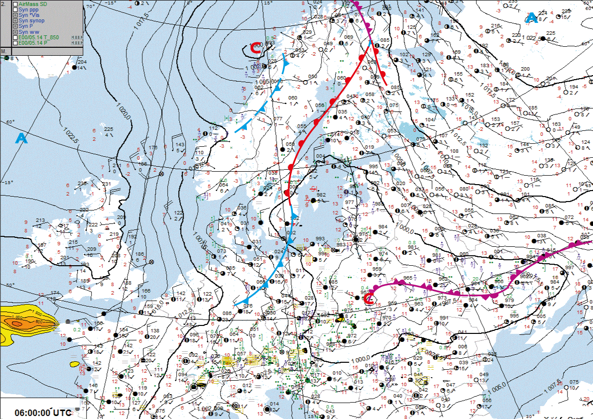
Figure 1: Frontal analysis for Europe 14.05.2016. - 06:00 UTC
In the Baltic States a trough was connected to the major low pressure area and determined the weather. A front was crossing the Baltic States from the south in south-west, north-east direction. Therefore in some places the rain was continuous and heavy.
During the night hours with the warm advection some thunderstorms were observed over northern Lithuania and border of Latvia. As the morning hours came, the convection lost its force and thunderstorms didn't continue to develop further on to the north. The main concern during this shift was - if the thunderstorms from Lithuania will reach Riga airport (RIX). As the radar images showed the precipitation zone really reached the airport at around 05:00 UTC, but it only brought rain and reduced visibility to 4500 m.
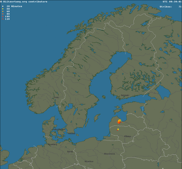
Figure 2: Blitzortung.org lightning data 14.05.2016 00-06:00 UTC
NWP and ePort Parameters
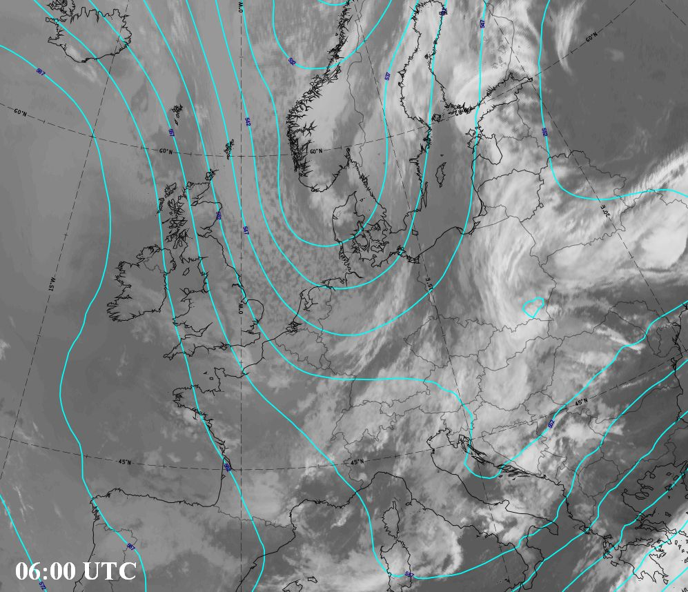
Taking a look at the parameters it is visible that south-westerly flow remained over the Baltic region without significant jet stream speeds. As well in 500 hPa and 700 hPa pressure gradient connected to the low over Poland is generally weak. Temperature advection at 700 hPa shows a region of cold air advection over the North Sea and some weak warm patch over Finland.
 |
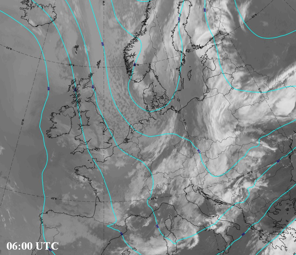 |
Figure 3: Geopotential height 500 hPa and 700 hPa
 |
 |
Figure 4: Temperature advection at 700 hPa and Isotachs at 300 hPa
Observations
Convection and thunderstorms - At first thunderstorms by NWP models are forecasted in eastern regions of Latvia, but in reality around midnight thunderstorms were observed in western part of Latvia and also in parts of Lithuania. After 02:00 UTC thunderstorms developed in central part of Lithuania and started to move northwards in direction of Riga airport. But after 04:00 UTC thunderstorms dissipated close to Latvian-Lithuanian border and no thunderstorms were observed during the remaining time in the shift.
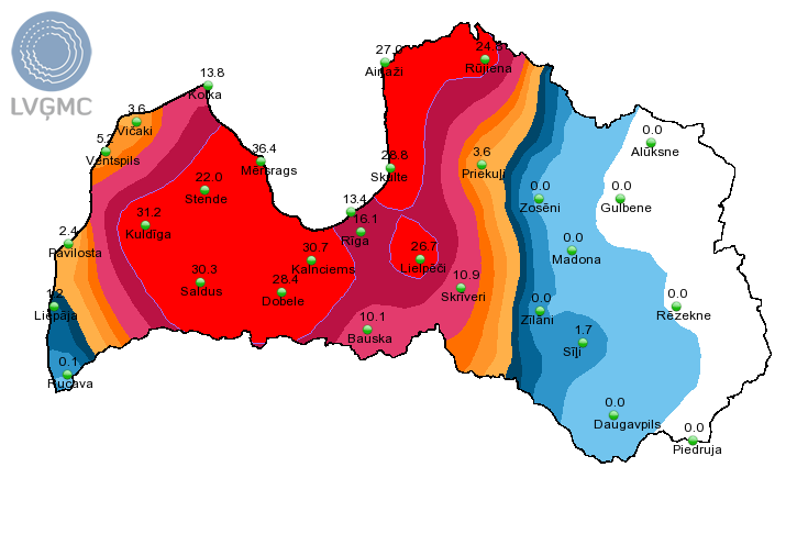
Figure 4: Precipitation amount in 24 hours (mm) 13.05. 18:00 UTC - 14.05. 18:00 UTC
Precipitation - As the precipitation zone was coming in from the south and didn't change its trajectory significantly, continuous rain with more than 25 to 40 mm in 24 hours was observed in some stations in western and central regions of Latvia (detailed values in the image above). That is not a severe situation at all. No flooding or any other damage due to rain was observed in this case.
Low clouds - NWP models in general did not forecast low clouds over Riga below 1500 FT. Only ECMWF in the morning (around 06-07:00 UTC) near Riga showed some small field of cloud base height below 1000 FT, but after that only in western part of Latvia.
In the real situation forecaster during this night shift didn't forecast low clouds, but around 06:00 UTC together with the precipitating clouds from the south also came patch of low clouds. Therefore, the forecaster in the next shift was forced to make a correction to the forecast (AMD). Also moderate SHRA with visibility 4000 m was observed. Observations from Riga airport and also TAFs are posted down below.
Observations and Forecasts for Riga airport (RIX)
Down below you can see METAR observations from airport Riga during your shift.
METAR/SPECI from EVRA, Riga International Airport (Latvia).
METAR EVRA 140220Z 14006KT 9999 FEW039CB 14/09 Q0998 NOSIG=
METAR EVRA 140250Z 15005KT 9999 FEW040CB BKN047 14/09 Q0998 NOSIG=
METAR EVRA 140320Z 15005KT 9999 -SHRA SCT043CB 13/10 Q0999 NOSIG=
METAR EVRA 140350Z 13004KT 9999 FEW028 SCT043CB 13/10 Q0998 NOSIG=
METAR EVRA 140420Z 13007KT 9999 SCT042CB 13/10 Q0998 NOSIG=
METAR EVRA 140450Z 13006KT 100V160 9999 SCT040CB SCT045 13/10 Q0998 NOSIG=
METAR EVRA 140520Z 14008KT 120V190 9999 SCT036CB BKN045 14/10 Q0998 NOSIG=
METAR EVRA 140550Z 20003KT 170V250 4500 SHRA BKN012 BKN028CB
OVC036 12/11 Q0998 NOSIG=
METAR EVRA 140620Z VRB02KT 8000 -SHRA BKN009 BKN012CB OVC015
12/11 Q0998 RESHRA TEMPO SCT009 BKN012=
METAR EVRA 140650Z 10004KT 9999 -SHRA SCT007 BKN009CB OVC012
12/11 Q0998 NOSIG=
METAR EVRA 140720Z 14003KT 110V180 9999 -SHRA SCT006 BKN008CB
BKN017 12/11 Q0998 TEMPO 3000=
METAR EVRA 140750Z 12004KT 8000 -SHRA FEW006 SCT014CB BKN020
12/12 Q0998 RESHRA NOSIG=
METAR EVRA 140820Z 13004KT 100V160 9999 SCT004 BKN017CB OVC023
13/12 Q0998 NOSIG=
METAR EVRA 140850Z 13005KT 9000 -SHRA FEW004 BKN017CB OVC022
13/12 Q0999 NOSIG=
METAR EVRA 140920Z 14004KT 110V170 7000 -SHRA FEW004 BKN017CB
OVC022 13/13 Q0999 NOSIG=
METAR EVRA 140950Z 13004KT 9999 -SHRA BKN007 BKN015CB OVC022
14/13 Q0999 TEMPO 3000=
Down below you can see TAFs from airport Riga that were issued during the shift that was used in this simulator.
Large TAF from EVRA, Riga International Airport (Latvia). FT 14/05/2016 02:02->
TAF EVRA 140202Z 1403/1503 13010KT CAVOK
TEMPO 1403/1409 SCT030CB
PROB40 1403/1409 -TSRA
TEMPO 1409/1415 13015G28KT 4000 -TSRA SCT030CB
TEMPO 1415/1424 4000 -SHRA SCT030CB
PROB40 1415/1424 TS=
TAF EVRA 140501Z 1406/1506 13010KT 9999 SCT040
TEMPO 1406/1409 -TSRA SCT030CB
TEMPO 1409/1418 13015G28KT 4000 -TSRA SCT030CB
TEMPO 1418/1424 4000 -TSRA SCT030CB=
TAF AMD EVRA 140702Z 1407/1506 13007KT 8000 BKN012 OVC015
TEMPO 1407/1411 3000 -TSRA BKN007 BKN010CB
BECMG 1411/1412 BKN015 BKN020
TEMPO 1412/1418 16015G25KT 4000 -TSRA BKN015CB
TEMPO 1420/1506 2000 BR BKN005 OVC012=
TAF EVRA 140804Z 1409/1509 13007KT 8000 BKN015 BKN020
TEMPO 1409/1412 3000 -TSRA BKN007 BKN010CB
TEMPO 1412/1420 16015G25KT 4000 -TSRA BKN015CB
BECMG 1420/1422 5000 BR OVC010
TEMPO 1422/1506 2000 BR BKN002 OVC007
BECMG 1506/1508 23007KT BKN015 BKN020=
Task 5
Down below is the correct SWL map with indications on which parts were written incorrectly. There were overall 4 mistakes in the drawn map.
After the simulation, please fill out this short survey.
This simulator was developed by Latvian Environment, Geology and Meteorology Centre.

==================================================================
* TECHNICAL NOTE: For the best interactive experience throughout this module please use the most recent versions of Firefox or Internet Explorer browser!