==============================
==============================
Macrosynoptic situation:
Hungary lay on the front side of a shallow trough of low pressure while the high pressure region was situated over Romania (Source: ECMWF MSLP + low level geopotential).
There was a cold front over western and southwestern Europe crossing from France through central Germany and Poland). There was a south-southwesterly flow of warm and relatively moist air from the Adratic Sea (Source: ECMWF 925 hPa ThetaE, AT 850 hPa; MSG: airmass RGB, IR, WV).
A shallow trough was still visible over western Hungary at 500 hPa. The temperature advection here was rather weak. At 300 hPa there was a weak westerly flow and the jet stream lay behind the cold front, over the northwest of continental Europe - northern France, Belgium, Netherlands and northern Germany (Source: ECMWF AT 500 hPa, 300 hPa wind).
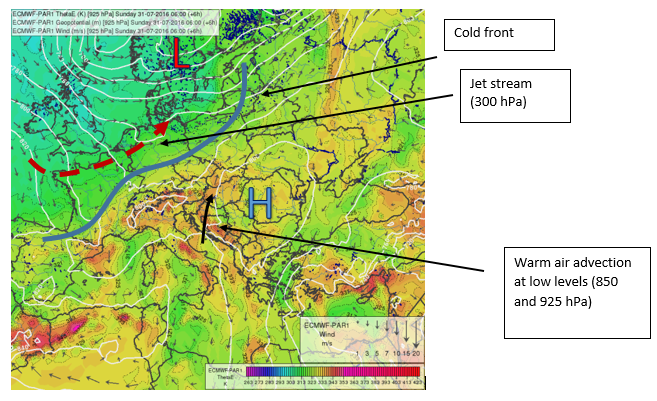
Figure 1: ECMWF ThetaE, geopotential and wind chart valid for 06 UTC
Mesosynoptic situation:
There was a trough of low pressure over northeast Austria, western Slovakia and northwest Hungary, and a region of higher pressure over eastern Hungary. The trough was somewhat elongated along its west-east axis and in this area we find a wind convergence (nr. 1), though the winds were weak. A convergence (confluence) of wind could be seen over Transdanubia in western Hungary as well (nr. 2). There were no significant pressure tendencies except in Austria, but even those were below 1 hPa. The convergence lines were fairly stationary, as seen throughout several periods. The pressure gradient over Hungary was moderate (nearly 1 hPa/100 km) and oriented east-to-west, suggesting moderate south-southwesterly wind at the surface. Also worth noting is the high dewpoint (19-20 °C) which indicates a high amount of surface moisture. Observations from both from synoptic stations and satellites showed the presence of low- and mid-level clouds (stratocumulus, altocumulus).
Source: SYNOP_Hungary. Surface observations and mesoscale pressure analysis, satellite: HRV, 24h microphysics RGB.
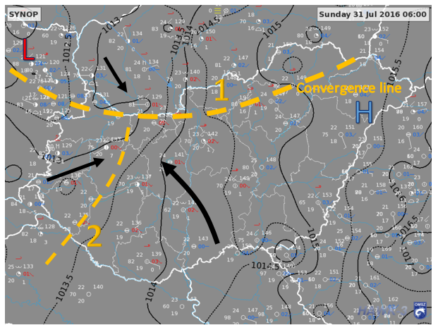
Figure 2: 06 UTC mesosynoptic analysis (MSLP and records of synoptic stations)
Analysis of soundings:
Both Budapest and Vienna 00 UTC soundings showed strong potential for conditional instability. Only the boundary layer (lowest 1 km) was stable due to radiation, and even that mostly in the Szeged sounding, where it is quite usual. However, the 850-700 hPa layer lapse-rate seemed to be high, which meant that the convection would develop very quickly after reaching its Level of Free Convection (LFC). The profile was relatively dry at mid- and high levels but there was still sufficient low-level moisture for convection since the dew point depression was not too high. The LCL was also not very high (1300-1500 m). Note that the axis of the low-level moist conveyor belt was between the Budapest and Vienna soundings, and thus there could be more low level moisture at places in western Hungary.
After reaching convection temperature (nearly 30 °C) the CAPE would be high, with little or no CIN. There was even the possibility of elevated convection from the top of the PBL. There was rather small or moderate wind shear and southwest-to-northwest veer. The K and LI indices indicated potential for thunderstorms, though the values were not extremely high. High DCAPE and the presence of dry air at mid-levels would suggest the possibility of downbursts and a strong cooling effect in the form of cold pool development in the proximity of thunderstorms.
Sources: Budapest, Vienna and Szeged 00 UTC soundings.
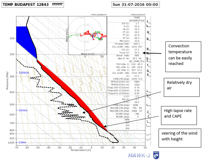
Figure 3: 00 UTC Budapest TEMP. The reddish area indicates positive CAPE after reaching the convection temperature
Current satellite and radar observations:
There was a non-precipitating (mid-level) cloudiness propagating from eastern Austria toward northwestern Hungary. Web cameras (not included in the training materials) showed that these were not towering clouds. No radar echoes had been observed until that point.
Sources: METEOSAT RGB Composite and HRV cloud, radar, webcamera

Figure 4: METEOSAT 24h Cloud Microphysics 05:55 UTC
NWP outlook for the next hours, large-scale:
The low-level trough over eastern Austria will be getting deeper. The frontal zone will approach northwestern Hungary in the evening hours. The 500 hPa flow will turn to a south-southwesterly direction and intensify in the afternoon as the upper air trough approaches from the west. Moderate upward large scale vertical motions were predicted for the west and north of Hungary at 700 hPa, while only weak or downward motions would be generated elsewhere. The large scale upward vertical motions at 700 hPa were predicted to increase in intensity and area of coverage in the afternoon, spreading out from the west. The predicted maximum temperature was 30-35 °C, well in excess of the convection temperature threshold.
Sources: ECMWF forecasts
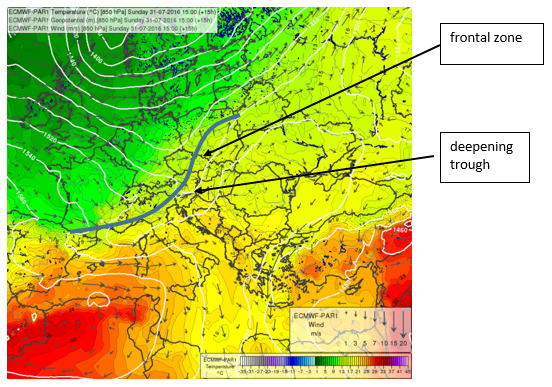
Figure 5: ECMWF AT850 hPa forecast for 15:00 UTC
Convective outlook:
CAPE values were already high in the morning, particularly in western Hungary which was probably influenced by the moist warm conveyor belt. The CIN was decreasing rapidly and there was very little or no CIN in the afternoon hours. The low-level (0-3 km) relative humidity was high enough for deep convection, especially in northern Hungary, but it was continuously decreasing towards the south. A similar tendency could be observed in the mid-layer (850-600 hPa). Regarding moisture the best conditions were in the northwest of Hungary, while the area south of the Transdanubian region was fairly dry. An increase in moisture could be expected in the late afternoon hours due to the trough and frontal boundary approaching from the west. The developed thunderstorms would move from southwest to northeast at the slow pace of 25-35 km/h. The deep-layer shear (DLS, 0-6 km) was quite low (below 10 m/s) but there was a tendency for it to increase over time. There were very high local TPW values, especially in northwestern Hungary (up to 40 mm). The predicted TPW was lower in the mountainous areas of Slovakia, but the model's resolution is too low to recognize small valleys where the TPW could be higher. The instability, moisture and wind shear maxima were somewhat dislocated but it was probable that deep convection would develop first along the troughs and convergence lines found in the mesosynoptic analysis, or close to the moist conveyor belts indicated by model outputs. Because of low DLS and the absence of stronger frontal forcing, one might expect the thunderstorms to have a more multicellular character, with clusters of cells or bands along the convergence lines. Hail or heavy precipitation could be expected due to high instability and the amount of precipitable water.
Source: ECMWF indices

Figure 6: ECMWF TPW forecast, valid for 06 UTC, showing high amounts of TPW in northwest Hungary
NWP outlook from mesoscale models:
The mesoscale (non-hydrostatic, 2.5 km horizontal resolution) model AROME detected the area of convergence over northern Hungary and predicted the development of convective cells between 7 and 12 UTC. The cells were expected to move in a southwest-northeast direction, as predicted by the ECMWF motion vectors, and could cause high precipitation (at least 20-30 mm) in the northeastern edge of the Transdanubian region. It was an important fact that the outflow would be oriented to the northwest of the cells and would not disturb the development of the cells. This would lead to the interesting scenario where it would not trigger further cells in the most unstable and moist region in northwestern Hungary where it would propagate - possibly due to unfavorable wind shear. The predicted convective wind gust speed was relatively low, below 15 m/s.
Source: AROME model forecasts from the 03 UTC run
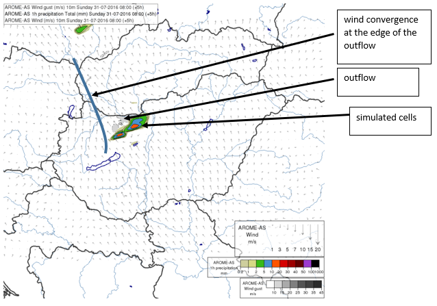
Figure 7: AROME 05h forecast, valid for 08 UTC
Summary for the first analysis:
There was a conditionally unstable, warm and moist airmass where local thunderstorm development could be expected from the morning onwards. These developments might precede the appearance of organized convection in the cold front, which was expected in the late evening hours. The convection development was supported by observed convergence lines, high dewpoint, soundings and NWP-derived parameters. Most of the outputs indicated the highest probability for intense convection in northwestern Hungary, where high CAPE and TPW were forecast. In this region large-scale lift could also be present. The mesoscale NWP model predicted the precipitating cells a little more to the east of the CAPE maximum. Heavy precipitation, hail and strong outflows were all possible according to the aforementioned material, and particularly so in the northwest.
Nowcasting part:
Analysis and nowcast at 07 UTC:
Mesoscale analysis:
Both convergence lines analysed at 06 UTC were also present in the 07 UTC analysis. The convection temperature had not been reached yet.
Radar and satellite observation:
The first radar echo appeared nearly where predicted by the mesoscale NWP. The radar reflectivity reached 40 dBZ very soon, which was a sign of high instability and strong updrafts. The convection was probably elevated on a convergence line because the near-surface layer might still have been stable. It appeared at the edge of the mid-level cloudiness observed at 06 UTC (see the 24h cloud microphysics).
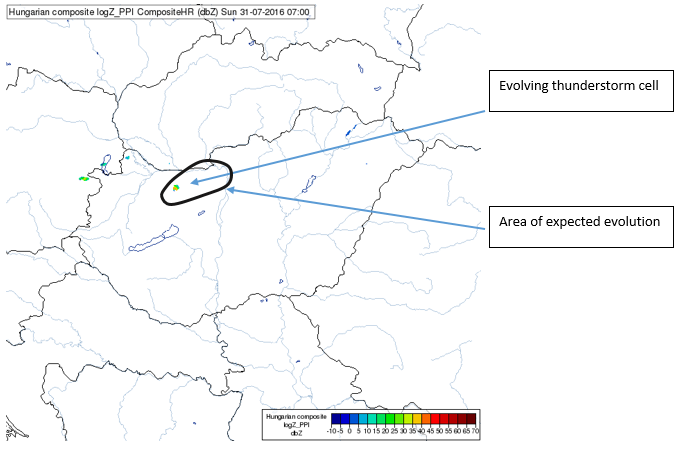
Figure 8: Radar reflectivity (Column maximum) image from 07 UTC
Proposed action: Because deep convection started to appear in the area predicted by the mesoscale model and supported by large-scale analysis, a warning of heavy precipitation, hail and strong wind would be issued for its vicinity and the region where it was expected to propagate within the next 1-2 hours.
Analysis and nowcast at 08 UTC:
Mesoscale analysis:
Both convergence lines observed earlier were still present in the 08 UTC analysis. There was little change in their position or in the mesoscale structure of the mean sea level pressure field. Note that one of the meteorological stations at Lake Balaton indicates continuous northerly wind, but this was a local effect. While the 2 m temperature was approaching convective temperature, mainly in the Slovakian southwest and southern Hungary, it was still 2-3 °C lower.
Radar and satellite observation:
Deep convection and thunderstorms evolved in a SW-NE line over northwestern Hungary, close to the border with Slovakia. The thunderstorms had a multicellular character and their motion resembled the simulated cells in mesoscale NWP forecasts.
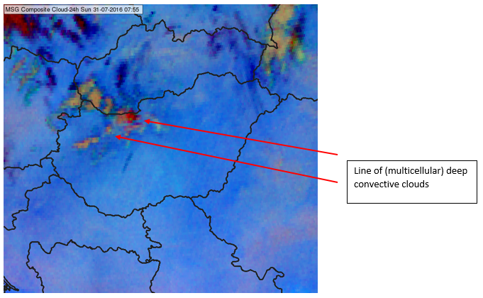
Figure 9: METEOSAT 24h Cloud microphysics, 08 UTC
Proposed action: Continuous monitoring of the situation and its evolution.
Analysis and nowcast at 09 UTC:
Mesoscale analysis:
Both convergence lines were also present in the 09 UTC analysis. The 2 m temperature reached or approached the temperature of convection (except of cloudy areas and regions with rain).
Radar and satellite observation:
A cluster of thunderstorms and deep convective cells was present in northern Hungary, northwest of the capital, Budapest. The system seemed to be back-building, with new cells emerging in the trail of the older ones. The south of the country was mostly cloud-free.
Updated NWP outlook from mesoscale models:
Updated 06 UTC run forecasts of the AROME mesoscale model were already available. The forecasts were in principle similar to the previous, 03 UTC run. The difference was that the more intense cells on the Hungarian-Slovak border would appear one hour earlier. These cells, which would cause some 30 mm of rain in one hour, were expected to develop around 11 UTC. The current situation was very similar to the one predicted for 09 UTC.
Nowcasting software (INCA-HU) output (available approximately at 09:30 UTC):
The nowcasting software predicted the southwest-to-northeast motion of the cells, similar to the mesoscale model, but they were located a bit more to the east. The propagation speed of the cells was below 10 m/s. Note that the software generally predicts (extrapolates) only the motion of currently detected thunderstorms, and does not forecast the development of new cells.

Figure 10: INCA 09:00 UTC precipitation + motion vector analysis (left) and forecast for 11:00 UTC (right)
Proposed action: Continuous monitoring of the situation and of its evolution.
Analysis and nowcast at 10 UTC:
Mesoscale analysis:
Convergence line nr. 1, the one oriented west to east, vanished but the south-to-north-oriented nr. 2 in western Hungary was still present. Local wind convergence was also in present in the vicinity of Szeged. In a large area the 2 m temperature was close to convective temperature. There was a meso-high north of Budapest, probably caused by the cold pool of the precipitating convection and also related to the presence of mid-level dry air and high lapse-rates seen in the soundings.
Radar and satellite observation:
New, strong cells developed in the thunderstorm cluster, close to the Hungarian-Slovak border. The development of new cells, probably along the outflow boundary of the older ones, was quite fast and a more significant factor in the precipitation field's evolution than the wind's effects on the existing cells. It could still be seen that the new cells were also built in a backward direction - now clearly to the west of the original ones, where low level convergence was analysed and high instability and TPW was predicted by the large-scale model outputs. This area was still cloud-free and thus the surface layer could be warm, unstable and favorable for fast development of new convective clouds.
Nowcasting software (INCA-HU) output (available approximately at 10:30 UTC):
There was no substantial change in the forecast of the cell propagation compared to the 09:00 UTC outputs.
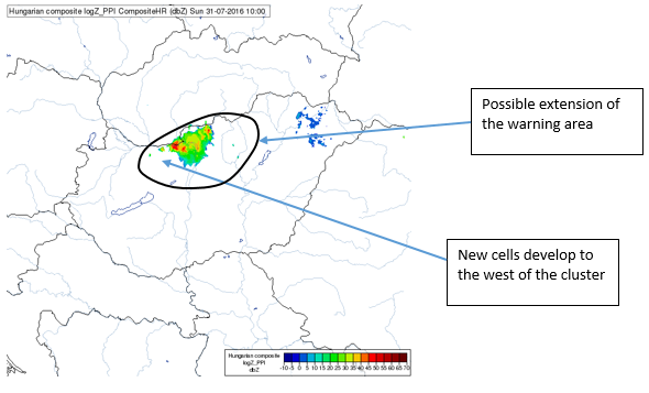
Figure 11: Radar reflectivity image from 10 UTC
Proposed action: After 10:00 UTC one should be able to tell that the situation has begun to deviate from the mesoscale model's forecasts. A warning may be issued or extended for the area west and north of the original thunderstorm cluster, in the direction of the propagating outflow.
Analysis and nowcast at 11 UTC:
Mesoscale analysis:
The low-level convergence was highest at the western edge of the convective cluster. A locally significant pressure difference of nearly 3 hPa/100 km developed along the western part of the Slovak-Hungarian border, probably due to the cold pool effect and high pressure in the thunderstorm cluster. One could also expect a mesoscale convective outflow from the area of high pressure. In sunny areas the temperature reached or exceeded convective temperature thresholds.
Radar and satellite observation:
A new, very intense cell developed just on the Slovak-Hungarian border at the cities of Komárno and Komárom, where the Váh river feeds into the Danube. The development of this cell was very rapid and its reflectivity was high, well over 50 dBZ. Heavy rain and hail could be expected in this cell. Satellite images showed fast cooling of the thunderstorm top (below -50 °C) and overshooting tops, as seen in HRV imagery. The presence of the overshooting tops could also be confirmed from webcam images, although those are not included in the training materials. It could indicate the development of strong updrafts. There was also rapid development in the mountainous central and southern parts of Slovakia.
Nowcasting software (INCA-HU) output (available approximately at 11:30 UTC):
There was an important change in the motion vector field compared to the earlier nowcasts and the mesoscale model forecasts. The direction of motion vectors was more southerly in the proximity of the strongest cells and indicated a much lower speed of propagation. If the evolution of the cell would be sustained which was a possibility since there was no precipitating convection in its inflow region - it could lead to high amounts of precipitation locally.

Figure 12: INCA-HU 1h precipitation nowcast and motion vectors
Proposed action: At this point a higher level warning should be issued for the proximity of the most intense cells, specifically indicating the possibility of flash flood and large hail. Flash flood potential is usually high in mountainous regions but also in bigger cities, often due to drainage problems.
Analysis and nowcast at 12 UTC:
Mesoscale analysis:
The mean sea level pressure distribution was similar to that of 11:00 UTC. The temperature dropped remarkably (by approximately 8 °C) at meteorological stations near the most intense storms. This indicated a strong cold pool and the possibility of a strong outflow, although there were no wind measurements from the area directly hit by the storms.
Radar and satellite observation:
There was still strong thunderstorm activity at the Slovak-Hungarian border, visible on both satellite and radar imagery. The longevity of the thunderstorm resembled that of a supercell storm; note also the smaller cell detached from it, which propagated northeast. However, the frequent changes of the cell shape and additional centers (OTs) also indicate a multicellular structure. An important feature was that while this storm developed in one place (or while moving east very slowly), the new intense cells over central Slovakia merged into a mesoscale convective system and propagated rapidly towards the northeast. There was also a line of shallow convective cloudiness spreading from the previously mentioned long-lived thunderstom cell to the northwest. It demonstrated that the cell's outflow propagated in a direction that was different from its inflow, which was from the south-southwest. This, together with the absence of deep convection and precipitation in the inflow region, was likely the key to the cell's longevity.
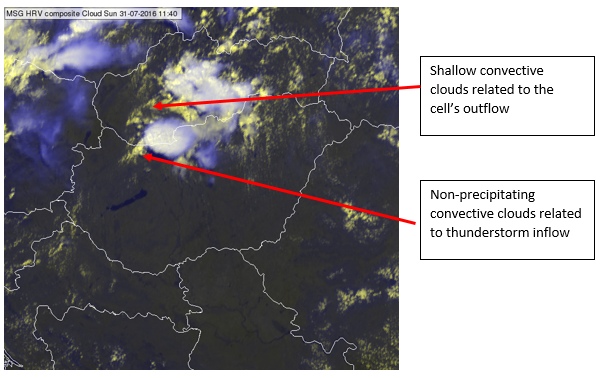
Figure 13: METEOSAT (HRV) image at 11:40 UTC
Proposed action: Besides contacting the authorities and continuous monitoring of the evolution of radar and satellite images, it would be advisable to get information about conditions in the area affected by the severe storms. Information like this could come from the media, websites with the records of voluntary observers, civil protection authorities, etc.
Analysis and nowcast at 13 UTC:
Mesoscale analysis:
The mean sea level pressure distribution was similar to 11 or 12 UTC but the pressure gradient at the Slovak-Hungarian border was already weaker. The center of the meso-high moved toward southern Slovakia. A convergence line could be found on Austria's eastern border.
Radar and satellite observation:
The thunderstorm activity became significantly weaker both on the Slovak-Hungarian border and over central Slovakia, but the system was still active over the east and north of Slovakia where the CAPE was also still high. Interestingly, further thunderstorms were not triggered to the west of the observed intense cells. This could be explained by less favorable conditions (drier, more stable environment) and the impact of the previous storms' outflow suppressing their development, such as by cooling the surface in a deep layer or causing unfavorable wind shear.
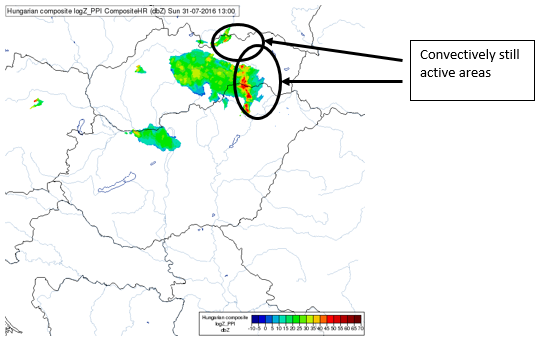
Figure 14: Radar reflectivity image, valid for 13:00 UTC.
Proposed action: Preparation for the next convective system presumably approaching in the evening hours (which could also be accompanied by severe weather) and analysis of updated mesoscale forecasts (AROME run from 09:00 UTC, not included in this simulator) and soundings, etc. The warning level in the northwest can be decreased.
Storm impact:
From available observations, the thunderstorm's impact was most severe over the Hungarian-Slovak border (cities Komárno and Komárom) and in central Slovakia (Kremnické Bane). There were no synoptic stations within the thunderstorm-affected areas, but some daily precipitation observations were available. At the station Hadovce (SHMÚ) near Komárno the amount of precipitation reached 79 mm in a single day. In the period discussed here, the precipitation intensity was 47 mm/1 h. It should be noted that the station is situated about 2 km north of the center of the highest radar reflectivity as identified in radar imagery, and of the reported flooding. The station at Kremnické Bane (central Slovakia) measured 122 mm with a peak intensity of 72 mm/1 h (www.shmu.sk). Large (2-3 cm) hail, strong wind and fallen trees were also observed in Komárno. The streets of both Slovak and Hungarian cities were flooded, causing extensive damage.
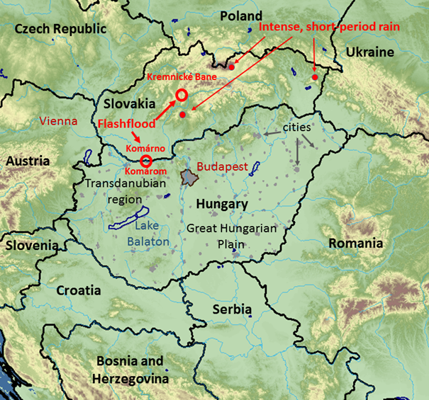
Figure 15: Map of the area, showing the impact of the thunderstorms.
Summary:
Both synoptic and mesosynoptic conditions were favorable for intense thunderstorm development, particularly in northwestern Hungary. Thunderstorm development likely took place elsewhere as well, but with less intensity and probability. The instability and low-level moisture content were high and deep convection could develop along or in the vicinity of stationary low-level convergence zones. Later a convective system developed and new, even heavier cells could develop along its outflow boundary. This could be attributed to the presence of dry mid-level air and large negative buoyancy, which enabled the development of a strong and large cold pool. The spreading of the cold pool triggered new cells in its highly unstable environment, although gravity waves could also have formed and supported the development of new convective cells farther away. Although deep-layer wind shear was fairly low, long-lived storms could also develop. The reasons for that and the dynamics behind them would need further study but it is probable that the orientation of the in- and outflows, which allowed back-building, could have played an important role. In combination with the cells' low speed of propagation this resulted in locally high amounts of precipitation and flooding.
In other parts of Hungary, such as the southeast, there was probably no sufficient lift to elevate the air parcels to their LFC. Large scale upward motion was absent in the 700 hPa vertical velocity field in much of southern and southeastern Hungary, possibly even weak downward motion (forecast by the ECMWF model) and elevated capping inversion levels could be generated. The southerly advection of drier air started earlier in these regions and inhibited, which was also the reason why thunderstorms did not form here although the convection temperature had been reached and some other parameters (such as CAPE) were high.
The aforementioned processes were only partially forecast by mesoscale NWP models although their initial state seemed to be very similar to observations. The situation was relatively difficult from the forecasting point of view. Although the convective environment was clearly favorable for heavy thunderstorms and even flash floods, it was not easy to predict where exactly the most intense cells would form and which areas would remain free of convective activity. The most important signs were the sudden formation of high radar reflectivity and the rapid cooling of thunderstorm tops in satellite infrared imagery. This happened in a region where high TPW, CAPE and low-level convergence were indicated by large-scale model outputs. The sudden change of the storm motion vector's orientation and the decrease in its propagation speed could signify that the evolution of the storm would differ locally from other cells over Hungary and Slovakia. However, the maximum lead-time of the flood warning could hardly exceed 30-45 minutes, which would probably still be too short for taking broader measures. Information could still be distributed to the populace in order to reduce their outdoor activities and have them seek shelter.
How this guide was prepared:
This guide was written primarily based on materials available in the EUMETRAIN simulator. Note that for technical reasons it was not possible to collect ALL forecast parameters, products and indices available in real-time forecasting. Some of them (such as lightning data, Doppler velocity radar data, 3D radar data and 10 min AWS measurements) would also help to identify the severe storms in this case. Although the impact of the thunderstorm was known at the time this guide was prepared, the analyses and proposed actions were largely constructed from a real-time forecasting point of view without using techniques that could not be utilized during usual duties. The time required for processing the radar and NWP images was also taken into account.
==================================================================
* TECHNICAL NOTE: For the best interactive experience throughout this module please use the most recent versions of Firefox or Internet Explorer browser!