Meteorological Physical Background
In contrast to the Norwegian cyclone type, where the depiction of the cold and the warm front can be reduced to a 2-dimensional sketch, a 3-dimensional perspective is needed to fully understand the physical processes involved in Shapiro-Keyser cyclones. In particular, it is important to differentiate between upper-level and surface fronts. During the evolution of Shapiro-Keyser cyclones, upper-level cold fronts clearly separate from their lower-level counterparts. This forms an essential constituent of the development and evolution of a Shapiro-Keyser cyclone.
For the conveyor belt theory that is applicable to both the Norwegian and the Shapiro-Keyser cyclone models, see here.
Detailed frontal analysis of the Shapiro-Keyser cyclone model
In the Norwegian cyclone model, which is more or less a description of moving air masses, the cold front catches up the warm front during the evolutionary process. The warm air is wrapped around the cold core of the system while simultaneously being lifted.
Shapiro-Keyser cyclones, in contrast, have a warm core and the catch-up process does not take place, at least not until the dissipation phase of the evolution. Hence, occlusions do not play a major role in the evolutionary process: cold and warm fronts suffice to describe this cyclone type.
In order to describe the life cycle of a Shapiro-Keyser cyclone, we adopt the same four evolutionary stages as for the Norwegian cyclone :
- Wave stage
- Intensification stage
- Mature stage
- Dissipation stage
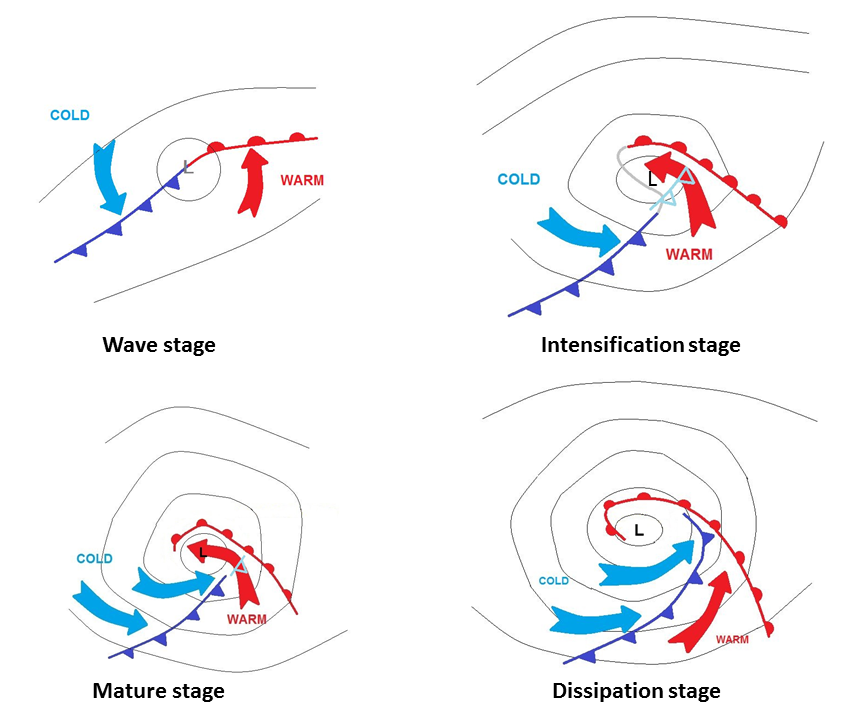
Figure 1: The four stages in the evolution of a Shapiro-Keyser cyclone, from the wave stage to the dissipation stage.
The most important differences between Norwegian and Shapiro-Keyser cyclones occur during stages 2 and 3 (i.e., the intensification and mature stages), while during stage 4, the dissipation stage, the development of the two cyclone types converges again.
Generally, Norwegian cyclones have a pronounced cold front and a less significant warm front, while Shapiro-Keyser cyclones have a strong warm front and a weaker surface cold front.
The intensification stage
During the intensification stage, the main differences between the Norwegian and Shapiro-Keyser cyclone models begin to appear. While for the Norwegian cyclone, the warm sector starts to narrow, leaving the cyclone centre in cold air, we find the Shapiro-Keyser cyclone centre invaded by warm air at lower levels, with a gap (frontal fracture) opening between the cold and the warm front. The warm front starts to wrap around the pressure minimum, delimiting the warm core from the surrounding cold air masses. In reality, the cold and warm front are still connected by an inactive air mass boundary that is usually not drawn on synoptic charts. This air mass boundary often shows a weaker temperature gradient then the cold front (see the grey line in Figure 2 below).
As the warm air protrusion mainly occurs in low to middle atmospheric levels, the upper part of the cold front above the protrusion remains intact and persists as an upper-level cold front (see the light blue cold front in Figure 2 below).
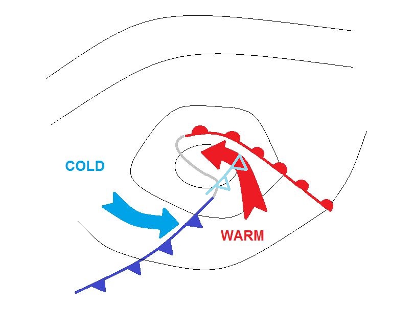

Figure 2:
Left: Schematic of the cold and warm surface front during the intensification phase. The grey line shows the cold frontal fracture.
Right: IR 10.8 μm imagery from 30 November 2021 at 21:00 UTC. Mean surface pressure (black) and ThetaE at 700 hPa (blue and red isolines).
During the early stages of the cyclone development, we usually find two jet streaks: the first is located behind the cold front and the other lies ahead of the warm front. At the beginning of the intensification stage, the jet streaks are nearly parallel to each other. This usually leads to the observation of a jet streak coupling, i.e., the left exit region of one jet streak is located at the right entrance region of the other jet (see Figure 3). Hence, upward motion in this area is reinforced.
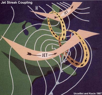
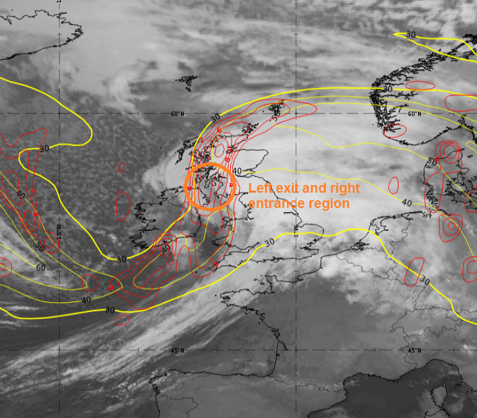
Figure 3:
Left: Schematic of two coupled jet streaks.
Right: IR 10.8 μm imagery from 30 November 2021 at 21:00 UTC. Isotachs and cyclonic vorticity advection at 300 hPa.
The mature stage
During the mature stage, the warm core of the Shapiro-Keyser cyclone becomes secluded from the warm sector by cold air masses advancing from the rear of the cold front (see Figure 4). The warm front around the warm core intensifies and the cold frontal fracture becomes narrower.
The protruding cold air (blue arrows in the schematic below) starts at higher levels and is triggered by the jet streak. Referring to the conveyor belt model, this is the so-called dry intrusion . The dry intrusion affects progressively lower atmospheric levels and hence contributes to the progressing of the cold front in direction of the warm front. The supply of warmer air masses from the warm sector into the system core gradually ceases.
The warm and cold front form a right angle, the so-called T-bone pattern characteristic of Shapiro-Keyser cyclones. There is no occlusion at this stage of development.
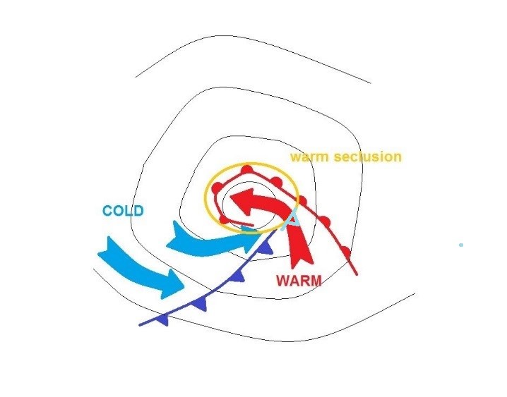
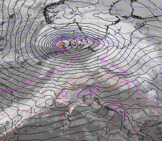
Figure 4:
Left: Positions of the cold and warm fronts during the mature stage. Red and blue arrows mark the advancing air masses.
Right: IR 10.8 μm imagery from 1 December 2021 at 15:00 UTC. Mean surface pressure (black) and temperature at 850 hPa (blue and magenta isolines).
During the mature stage, the angle between the two jet streaks becomes almost 90° (see Figure 5). The coupling of the jet streaks thereby weakens and the deepening of the surface low decelerates.
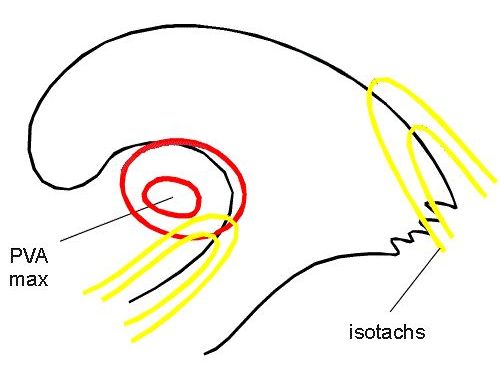
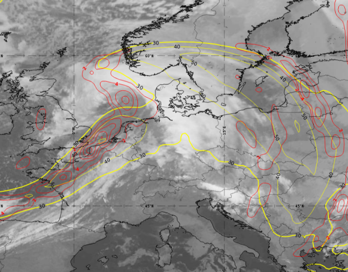
Figure 5:
Left: Schematic of the jet streak positions and the positive vorticity advection maximum (PVA max) at 300 hPa during the mature stage.
Right: IR 10.8 μm imagery from 1 December 2021 at 06:00 UTC. Isotachs at 300 hPa in yellow and PVA at 300 hPa in red.
The dissipation stage
The dissipation phase of the Shapiro-Keyser cyclone is characterized by:
- An increasing surface pressure at the system core;
- A secluded warm core;
- The cold front rejoining the warm front;
- A weakening warm front around the warm core.
During the dissipation stage, cold air protruding from behind the cold front wraps around the warm core of the Shapiro-Keyser cyclone. The warm core of the cyclone is located in the polar air mass and the temperature gradient to this surrounding colder air mass decreases.
Aging Shapiro-Keyser cyclones follow physical processes typical of Norwegian cyclones, such as the merging of the warm and cold fronts to form an occlusion. This is the case when cold air from behind the cold front wraps around the warm core. Subsequently, the cold front connects to the warm front (closing the cold frontal fracture) and forms an occlusion.
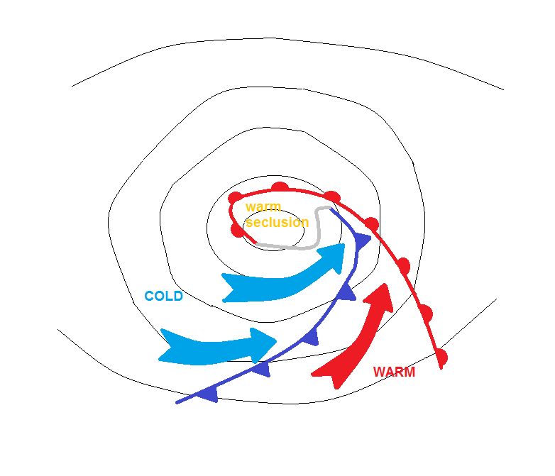
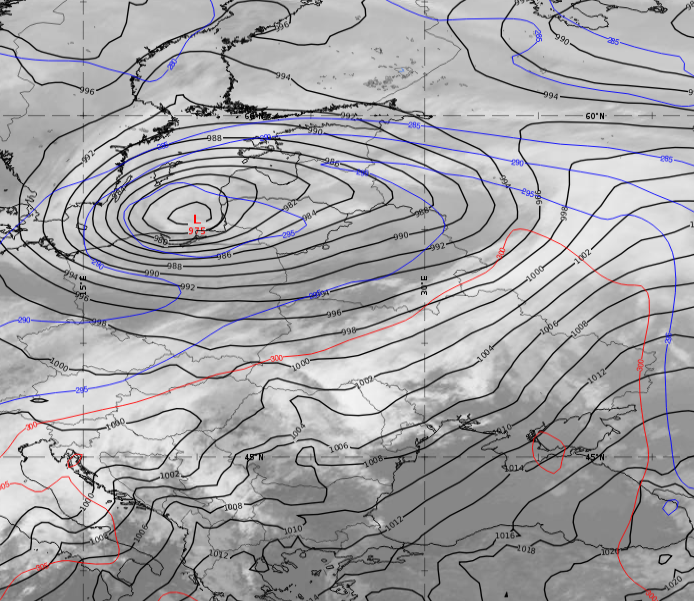
Figure 6:
Left: Schematic of the cold and warm surface front during the dissipation phase. Red and blue arrows mark the advancing air masses.
Right: IR 10.8 μm imagery from 2 December 2021 at 12:00 UTC. Mean surface pressure (black) and ThetaE at 700 hPa (blue and red isolines).
The left-exit quadrant of the jet is no longer superimposed on the surface pressure minimum; upper-level divergence ceases to act as a trigger for the surface low. The two jet streaks are aligned at a more acute angle then before.
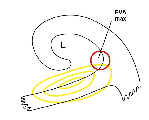
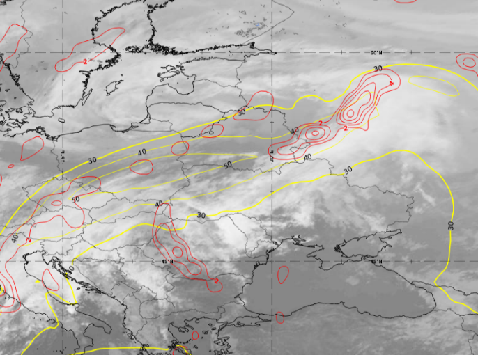
Figure 7:
Left: Schematic of the jet streak positions and the positive vorticity advection maximum (PVA max) at 300 hPa during the mature stage.
Right: IR 10.8 μm imagery from 2 December 2021 at 12:00 UTC. Isotachs at 300 hPa in yellow and PVA at 300 hPa in red. Mean sea level pressure in black.