Table of Contents
Cloud Structure In Satellite Images
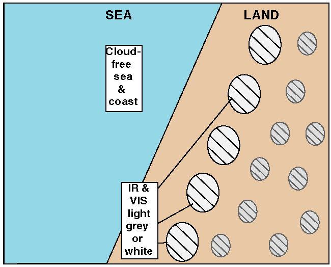
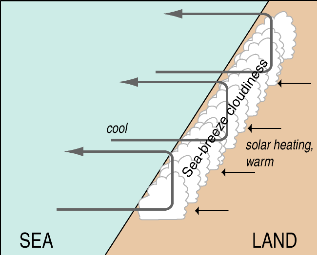
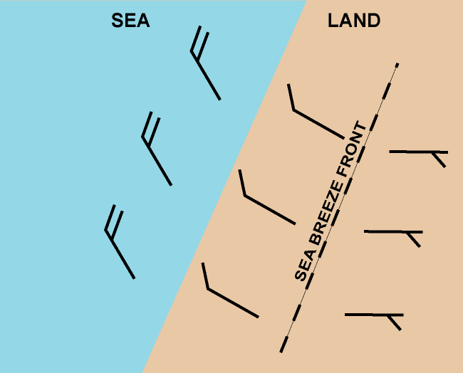
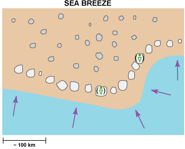
A Sea-Breeze is a thermally driven circulation on the coastlines of sea and large lake areas. It is commonly observed during the spring and summer, when the temperature difference between sea and adjacent land areas is large.
- In satellite images a Sea-Breeze is characterized by a cloud-free area along a coastline of sea and large lake with cumuliform clouds, often present over land.
- The convective clouds, often in a line parallel to the coastline separating the cool and dry maritime air from the warm air over land is called the Sea-Breeze front.
- The detection of the boundary, separating the cloud-free and cumuliform clouds, is possible by using either VIS (cumuliform clouds appear as white pixel values), RGB - combinations like Natural Colour RGB and E-view RGB and IR (white to grey pixel values) channels.
- Water vapour imagery does not generally allow the detection of a Sea-Breeze, but in case with deeper convection the line of convective cells can be distinguished.
- The Sea-Breeze front may appear as an intensifying line of Cu or CB at the leading edge of the Sea-Breeze.
- Low RH in the boundary layer makes it difficult to detect the Sea-Breeze front on satellite imagery. One or two individual CU-clouds with short life time may develop.
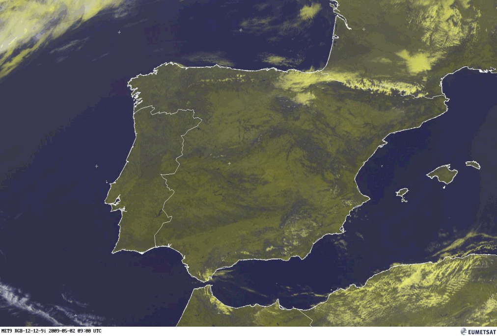
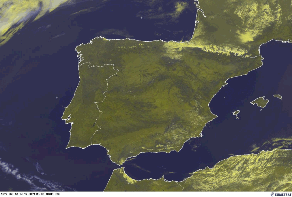
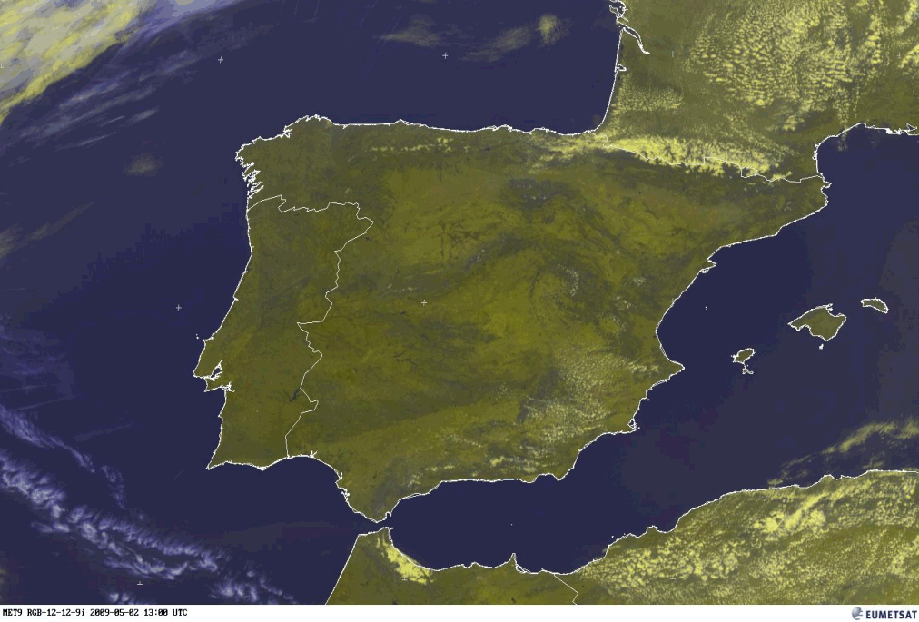
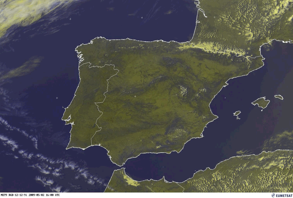
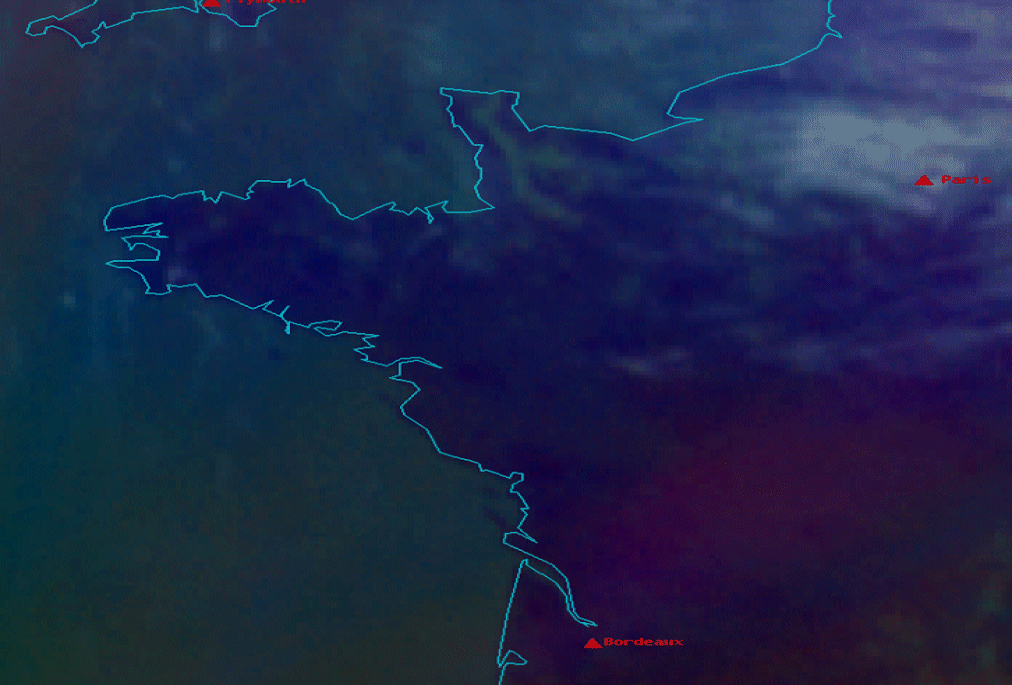
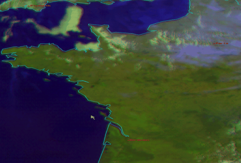
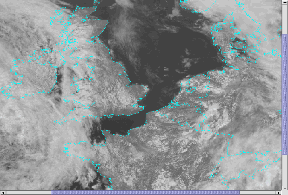
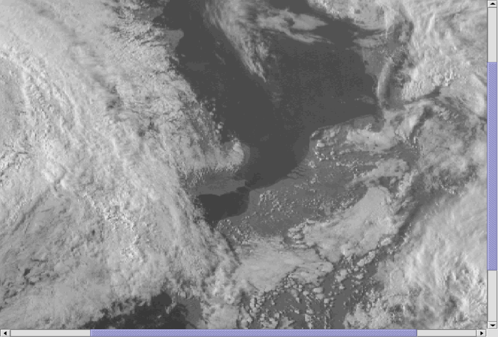
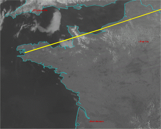
The first example below presents a lifecycle of a Sea-Breeze front in 4 successive images over the southwest coast of France and the southeast coast of Spain. In the E-view RGB (combination of HRV + IR10.8) the developing of the convective clouds can be observed. Especially over SW France the track of the Sea-Breeze front inland and the widening of the cloud free area are easy to detect. The convective clouds of the Sea-Breeze front over southern Spain develop at the southeast side of the mountains inland; the decaying at 16.00 UTC is evident.
|
02 May 2009/09.00 UTC - Meteosat 9 HRV/IR10.8 image
|
02 May 2009/10.00 UTC - Meteosat 9 HRV/IR 10.8 image
|
|
|
|
|
|
02 May 2009/13.00 UTC - Meteosat 9 HRV/IR 10.8 image
|
02 May 2009/16.00 UTC - Meteosat 9 HRV/IR 10.8 image
|
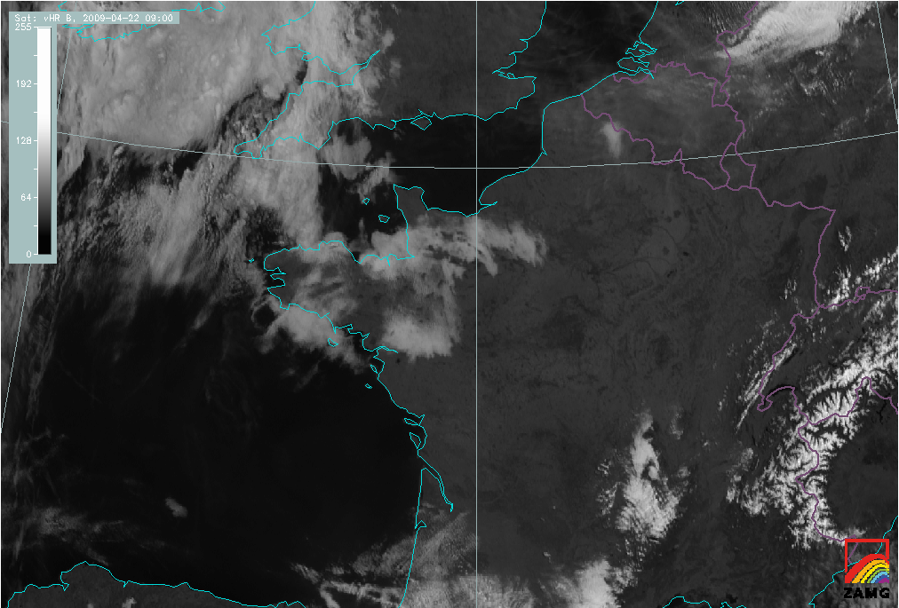
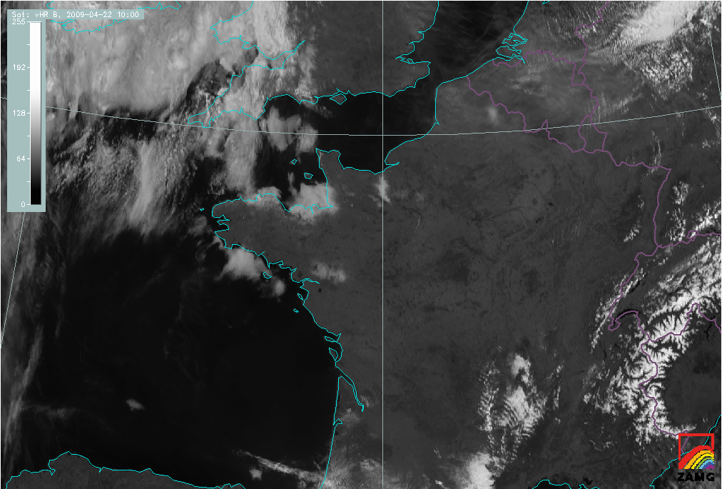
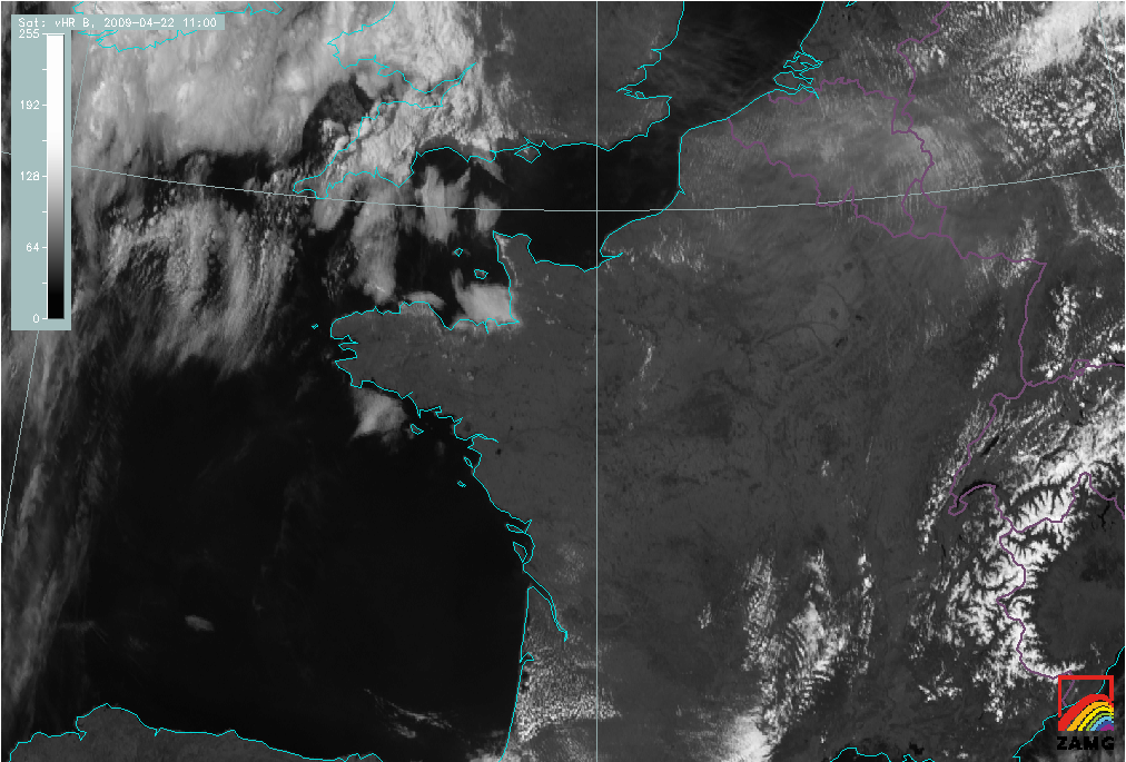
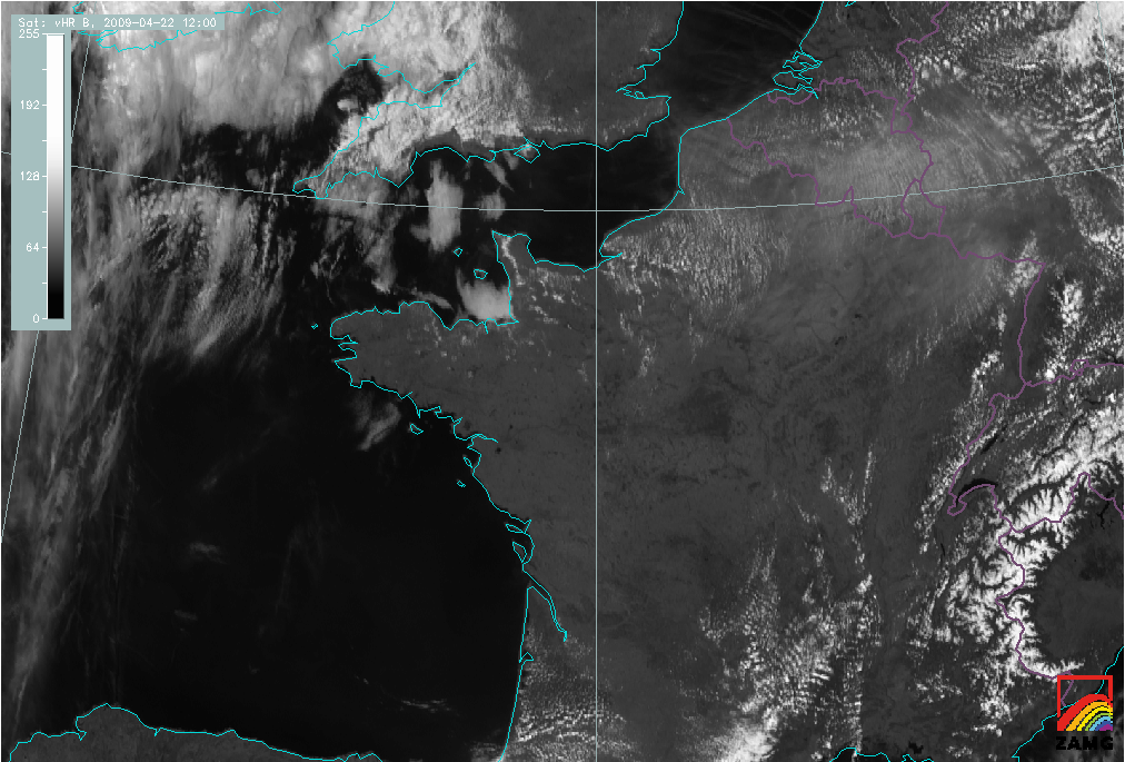
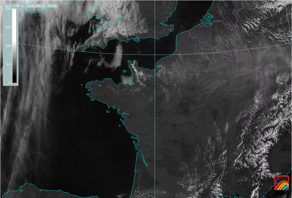
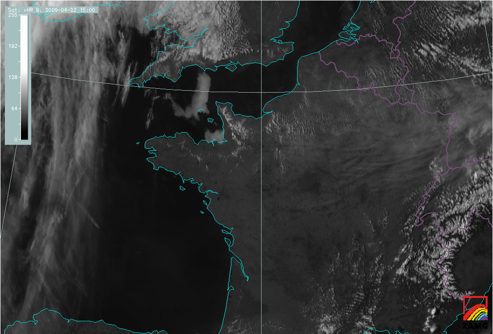
In the VIS image loop below, the development of the Sea-Breeze can be seen as rather rapid growth and spreading of cumulus cloudiness around local noon.
|
22 April 2009/14.00 UTC - Meteosat 9 HRV image
|
22 April 2009/09.00 - 15.00 UTC Meteosat 9 HRV image hourly image Loop
|
|
The images below are examples of the Airmass RGB, to the left, and the combination of a VIS(0.6), NIR(1.6) and IR(10.8) to the right. All channels, used in the Airmass RGB, are not applicable to the shallow convection in the Sea-Breeze front, unless of course in situations where the Sea Breeze front will act as a first trigger to deep convection, associated with upper air features. This is not the case in this example.
|
22 April 2009/14.00 UTC - Meteosat 9 WV6.2/WV7.3/IR 9.7/IR 10.8 (Airmass RGB) image
|
22 April 2009/14.00 UTC - Meteosat 9 0.6/1.6/10.8 image
|
|
|
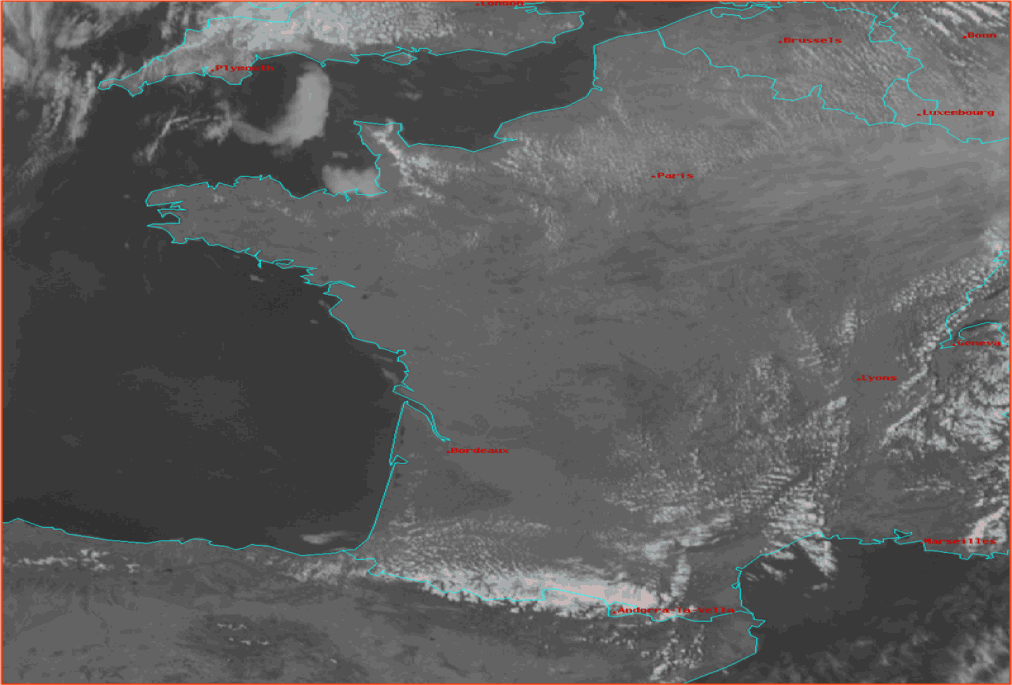
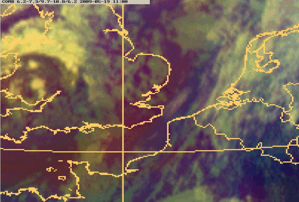
The image on the right hand side is an example of another RGB - combination. The difference in cloud structure between the convective clouds in the Sea-Breeze front over Normandy, the marine low level clouds over the British Channel and the remnants of low level clouds in the coastal districts southwest of Normandy are hardly to detect. Apparently a combination of 0.6 and 1.6 micrometre is not favourite for detection of this kind of different cloud types, but the superadded IR - channel makes it easy to distinguish the high level clouds more to the east over France.
|
19 May 2009/11.45 UTC - Meteosat 9 HRV image
|
19 May 2009/11.00 UTC - Meteosat 9 (WV6.2-WV7.3)/(IR9.7-IR10.8)/WV6.2 (Airmass RGB) image
|
|
|
A second example on the use of Airmass RGB and HRV is presented in the images above. The bluish colour over the south part of the North Sea, The Netherlands and the north part of France clearly indicates the Sea Breeze development is in the same, polar air mass. Over the United Kingdom and The Channel Islands the bluish colour changes into reddish : dry descending stratospheric air above the original polar air. High level clouds appear as white clouds in the Airmass RGB, the lower convective clouds, associated with the Sea Breeze front well depicted over the north west part of France in the HRV - image right, are hardly recognizable. Unfortunately the high level clouds over the west part of The Netherlands make the identification of the Sea Breeze difficult.
|
19 May 2009/11.00 UTC - Meteosat 9 (WV6.2-WV7.3)/(IR9.7-IR10.8)/WV6.2 (Airmass RGB) image
|
19 May 2009/11.45 UTC - Meteosat 9 HRV image
|
|
|
The images above show an evolution of a Sea-Breeze front over The Netherlands. More information of this specific situation is available in the next chapters.
Appearance in AVHRR images
AVHRR images help to locate the Sea-Breeze more accurately over land because of the better spatial resolution. Even quite small cumulus clouds
can be seen.
The diurnal variation of Sea-Breeze cloudiness and the track of the Sea-Breeze front can be studied by using consecutive AVHRR images.
|
31 May 2001/14.08 UTC - NOAA RGB image (channel 1, 2 and 4)
|
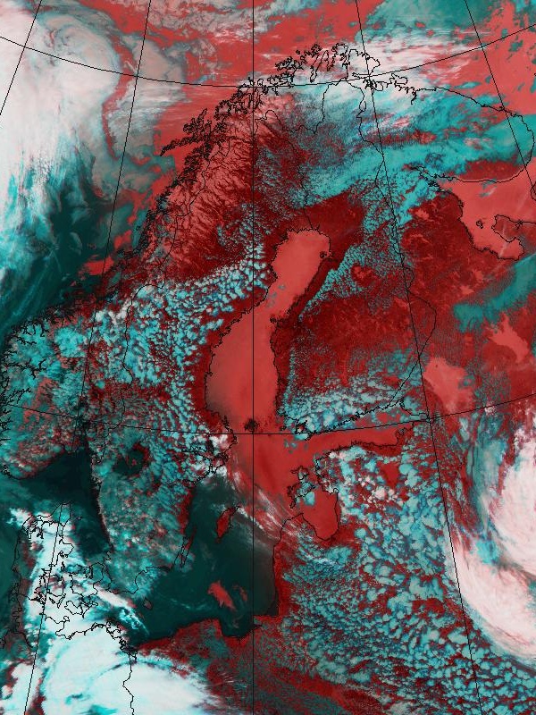
31 May 2001/14.08 UTC - NOAA RGB image (channel 3, 4 and 5)
|
|
|
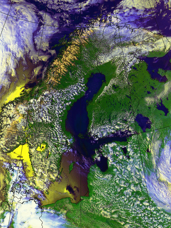
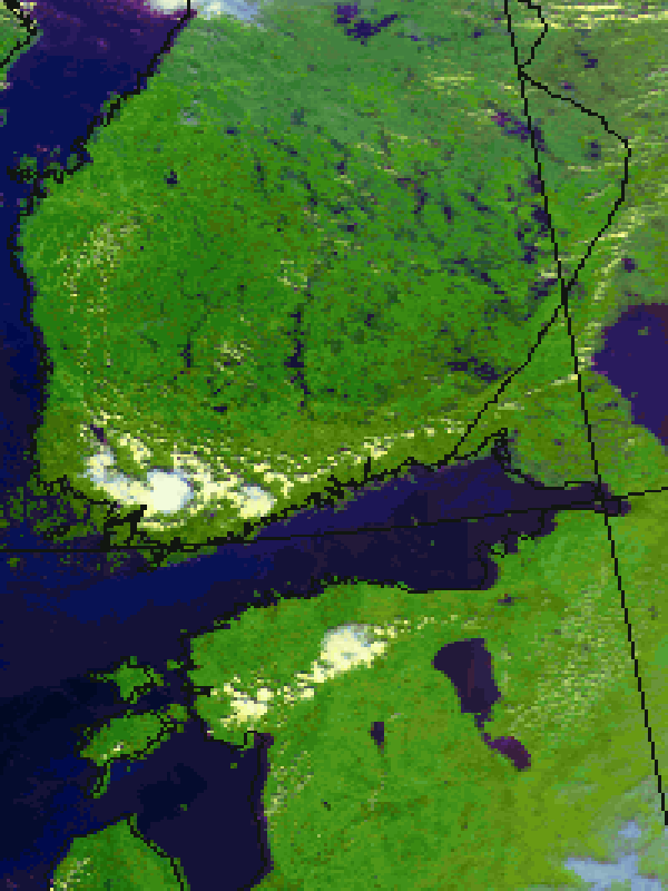
In the images above the Sea-Breeze on the Scandinavian coasts are the cloud-free areas more or less following the shape of coastline.
Cumuliform cloudiness marking the Sea-Breeze boundary appear as lumps of white - bluish clouds over land.
In western Finland, along the Gulf of Botnia, the convective clouds of the Sea-Breeze front form a line almost parallel to the coast.
The extension of the Sea-Breeze inland, although the RH of the air mass further inland is too low to support any cumulus development, is clear.
Meteorological Physical Background
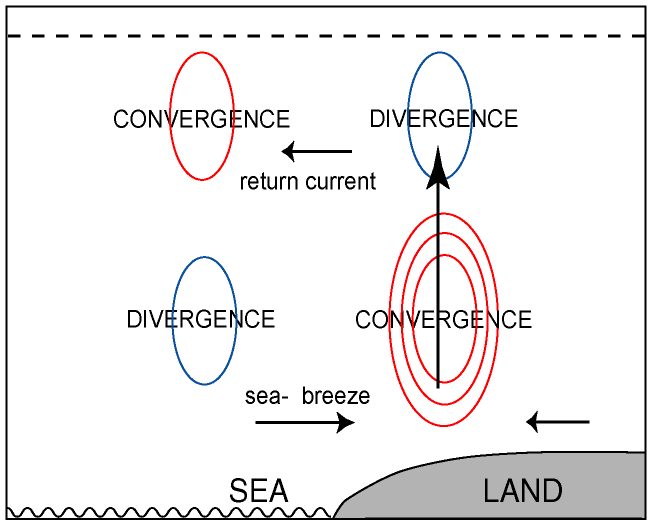
The Sea-Breeze is a circulation that develops due to differential heating of air over land and sea. As the sun heats the boundary layer over land, the resulting pressure gradient causes the movement of low-level air from the sea to land (Sea-Breeze) with a return flow aloft (return current).
The Sea-Breeze circulation is able to strengthen and/or changing (veering) the surface wind in large scale synoptic onshore circulations.
The existence and intensity of the Sea-Breeze depends strongly on seasonal and latitudinal factors and on the time of day. In tropical and subtropical coastal regions the Sea-Breeze is a regular phenomenon throughout the year bringing a pleasant cooling. At higher latitudes it is a common feature during spring and summer only, Clear skies, strong insolation and a temperature difference between land and sea at its maximum are relevant and important factors for the Sea-Breeze to develop.
Daily Life Cycle
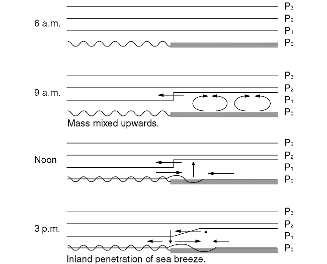
A simplified overview is provided using the following model. The left side of the scheme is a presentation of the developing onshore - wind in the Sea Breeze circulation. The scheme to the right is an example of the shallower Land Breeze circulation at night.
|
|
|
|
|
A Sea-Breeze normally starts in the morning, a few hours after sunrise, when the solar radiation indirectly heats the boundary layer over land. A classical explanation for the development of a Sea-Breeze is the "Upwards" Theory: the differential heating between land and sea leads to the development of a horizontal pressure gradient above the coastal areas (mass convergence of rising air), setting in a flow from land towards sea (left side of scheme above). This upper flow is called a "return current", even though it may develop before the actual Sea-Breeze. The mass divergence and resulting pressure fall over land and the convergence and pressure rise over the sea initiate the Sea-Breeze close to the surface
There are other explanations for the initiation of Sea-Breeze:
- Sea-Breeze is initiated at low levels, or
- Both Sea-Breeze and return current (representing the air flowing from land to sea above Sea-Breeze) develop practically at the same time.
- Sea-Breeze as a result of the difference in sensible heat flux over sea and over land.
The return current aloft carries the excess of air towards the sea. Cloud development frequently occurs in the ascending part of the circulation, while clouds tend to dissipate over the sea, where the air is sinking. When the air is very dry, as often is the case in spring and early summer, the cumulus clouds may not appear at all. In these cases the use of satellite imagery is clearly problematic for the detection of Sea-Breezes, while it may still be detectable using other remote sensing techniques, such as sensitive weather radars.
In the early afternoon, when the boundary layer heating over land is at its maximum, the highest activity of the Sea-Breeze circulation does occur with an inland track of generally tenths of kilometres - in some cases, even over a hundred kilometres. While moving inland the Sea-Breeze front tend to accelerate.
If the large-scale flow is weak, the direction of the Sea-Breeze often veers with time. This is a result of the Coriolis force having impact on the air flow. At higher geographical latitude and comparable strength of the forcing mechanism the component perpendicular to the coastline will be smaller or in other words the veering of the wind will be larger and the track inland will be smaller.
Generally the Sea-Breeze circulation have the largest horizontal dimensions in the Tropics.
Another factor influencing the wind direction along the coast is the regular existence of thermal lows over land in the afternoon.
A Sea-Breeze has a typical vertical dimension of 300 - 1000m, with the strongest wind speed at 50 to 200m above the surface. The return current is about twice as thick as the Sea-Breeze, leaving for the total vertical dimension of the Sea-Breeze circulation typically about 1 to 3 km. In the return current almost the same amount mass of air is returned to the sea, compared with the mass of air transported inland by the Sea-Breeze wind.
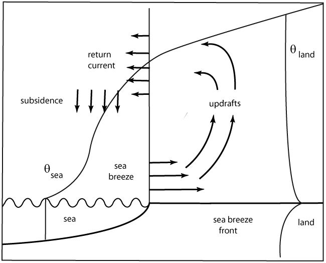
The scheme in the image above presents all horizontal and vertical processes. At the landside part of the Sea-Breeze the vertical speed generally reaches a few m/s and if the LCL is reached convective clouds develop.
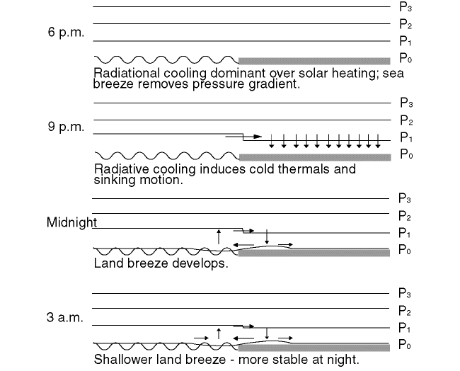
Later in the day, as solar radiation decreases, the Sea-Breeze dies out, the thermals weaken and the cumuliform clouds gradually disappear.
Factors influencing the Sea-Breeze development
Sufficient temperature contrast between the land and sea surfaces is needed for the initiation of the Sea-Breeze. In this respect the physical background differs for Coastal Convergence (see Coastal Convergence ) in which the differential friction over land and over the sea is the main component for the development.
The coastline shape can either enhance or inhibit Sea-Breeze development. For example, merging of two Sea-Breezes originating from both sides of a peninsula enhances convection. On the other hand, over land areas adjoining bays the Sea-Breezes tend to diverge, which enhances low-level descent of air.
The image below shows a case over Finland, in which Sea-Breezes (barely visible as a line of cumulus) merge along the Finnish west and south coasts, producing some intensive, local Cb Clouds in the south-western corner of Finland. Meanwhile, along the coast adjacent to the eastern Gulf of Finland the wind field is more divergent and no clouds are produced.
|
02 August 1999/13.29 UTC - NOAA RGB image (channel 1,2 and 4)
|
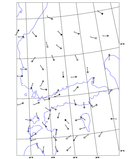
02 August 1999/15.00 UTC - synoptic wind observations
|
|
|
The low-level gradient wind steers the development of a Sea-Breeze:
- If the large-scale flow is weak, the Sea-Breeze circulation dominates.
- If opposing (offshore) large-scale wind exists, it can either inhibit the Sea-Breeze totally or slow down the development of the Sea-Breeze. Under these circumstances the Sea-Breeze may develop late in the afternoon moving inland very slowly.
- The most intensive Sea-Breeze fronts develop in association with an opposing light large-scale flow. Strong low-level convergence within the Sea-Breeze front may result in strong convection restricted to a narrow line along the front.
- If moderate or strong large-scale onshore winds exist, the Sea-Breeze circulation often has no possibilities to develop, as the large-scale flow advects the cool sea air over land, reducing the temperature and pressure gradients.
- Weaker onshore winds however can change into a developing Sea-Breeze front. An example is presented in the chapters cloud structure, weather events and cross sections.
Additionally, capping temperature inversion above the boundary layer tends to intensify the Sea-Breeze circulation.
Sea-Breeze study with a mesoscale model by using sensible maximum heat flux
The "Upwards Theory", based on temperature differences over sea and land, is not always the best tool to be used in Sea-Breeze forecasting, it has a few disadvantages. Often the pressure is not falling in a small area near the coast but over a much larger area inland. Consider two boundary layers, 1000m and 2000m thick, with no difference in initial θl (over land) and θS (over sea). If, by the end of the day, no temperature differences exist between the two heated layers the total amount of used energy to warm the thickest layer is twice as much compared to the thinner layer. Double the heat, double the pressure gradient (to be calculated with the law on hydrostatics) with in the end a stronger Sea Breeze in the thickest layer.
For understanding the physical and dynamic processes, explaining the Sea-Breeze circulation, a study was done with a numerical model in a boundary layer of 2000m. At the start the atmosphere is at rest and strong solar insolation is heating the air over land over a much larger surface then the coastal regions, making the air to expand not only vertically but also horizontal towards the sea.
The total amount of heating on a specific day can be calculated by a mesoscale model. It is the total amount of energy since day break up to the time at the maximum strength of the Sea-Breeze. This is called the maximum sensible heat flux with values ranging from 100 to 400 W/m2, 200 W/m2 is often used (graphs in Key-Parameter and Weather - Events).
The vertical velocities at the leading edge of the heated air over land are stronger in relation to the coastline due to the existing horizontal velocities towards the sea, the offshore low level wind component. At low levels, a 100 metres, the so developed convergence over sea initiates little pressure increase over sea and a quit rapidly turning of the wind and the onset of the See-Breeze. These new developed onshore wind of the Sea-Breeze initiate divergence over sea and convergence over land. Pressure levels lift slowly over land due to the mass convergence and the onset of a return flow (offshore) above the flow of the Sea-Breeze. This explains why the originally weak flow at a height of about 1000m, following the veering of the low level flow, soon to back again into an offshore wind.
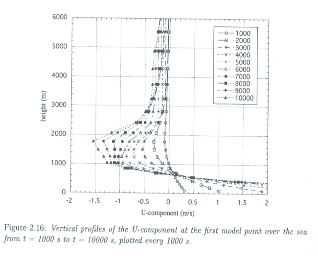
The image below is a scheme of the vertical extent of the U-component of the See-Breeze from this study. Below 500m an increasing (in time
after the onset) westerly wind component exist. At the same time a return flow sets in just above the Sea-Breeze with equal strength, reaching
a maximum around 1500m. This vertical profile is calculated for a grid point over the sea close by the coast, the starting point of the
Sea-Breeze.
A Sea-Breeze circulation starts with an opposite wind, an offshore wind, soon changing into an onshore wind at low level, followed by a return
flow (offshore) above within about half an hour.
|
Vertical profiles of the U-component in Sea-Breeze circulation. (Sea-Breeze studies 1999 A.B.C.Tijm)
|
|
|
Key Parameters
- Temperature difference between land and sea:
Cool sea adjacent to the warmer land surface. - Maximum of sensible heat flux calculated by a mesoscale model.
- Low-level geostrophic flow:
- weak geostrophic wind at lower levels favours the development of Sea-Breeze (see example below)
- A weak opposing flow in the lower troposphere (< 850 hPa) tends to increase the Sea-Breeze circulation.
- Sea-Breeze index <1 implies a lower opposite flow compared to the calculated strength of the Sea-Breeze.
- Surface winds:
Veering with the passing through of the Sea-Breeze front, offshore wind direction changes into onshore wind direction opposite the coast-line. With the progress of the Sea-Breeze front inland the onshore wind tends to veer more and more and so diminishing the component perpendicular to the front. - Convergence near surface:
Convergence produced by opposing surface winds.
Temperature difference between land and sea
|
|
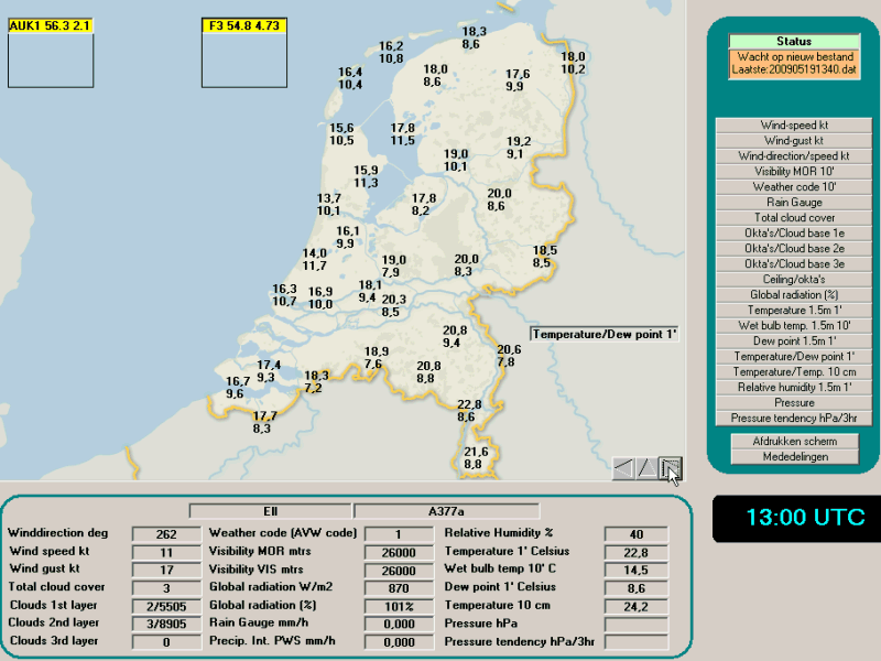
19 May 2009/13.00 UTC - T (up) + Td (down) reports over The Netherlands in Sea-Breeze circulation
|
|
|
|
|
|
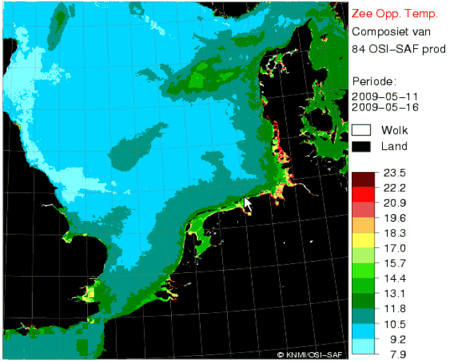
11 - 16 May 2009 - Meteosat 9 Sea Surface Temp.
|
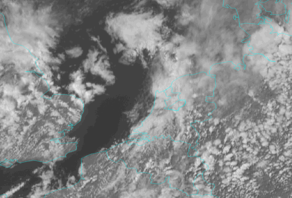
19 May 2009/14.00 UTC - Meteosat 9 HRV image
|
The images above are an example of the traditional explanation of the development of Sea-Breeze circulation as a result of temperature differences over sea and over land, the general scheme is in the image top left. The image top right is an example of Sea-Breeze as a result of low-level geostrophic flow over The Netherlands. Under a ridge of high pressure with axes just to the west of Holland the Sea-Breeze developed in the late morning and moved more the 50 km inland. With 13 degrees at the coast and almost 21 degrees Centigrade in the east the differences were not that high.
The lower images are the average sea surface temperature as measured and computed by satellite info (OSI-SAF). In the satellite image on the right side below the convective clouds of the Sea-Breeze over the west part of Holland are difficult to recognize due to the overlaying high level clouds.
Low-level geostrophic flow
|
13 June 2001/12.00 UTC - 850 hPa wind (barbs) and geopotential height (black) on Iberian peninsula
|
|
|
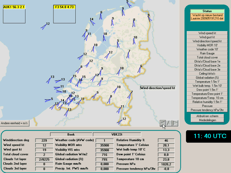
Surface winds
|
|
19 May 2009/11.40 UTC - Windreports over The Netherlands at the start of a Sea Breeze
|
|
|
|
|
|
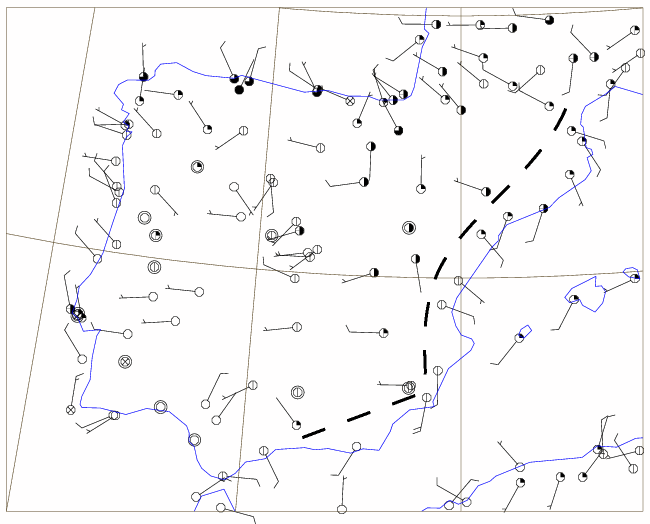
13 June 2001/12.00 UTC - surface synoptic wind observations with an estimated position of Sea-Breeze front (dashed line)
|
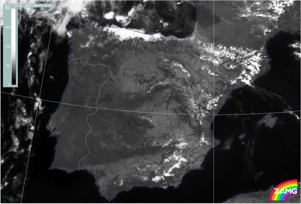
13 June 2001/12.00 UTC - Meteosat 8 VIS image
|
A Sea-Breeze observed over the Spanish south-east coast. The line of the Sea-Breeze front cannot be delineated accurately due to insufficient
surface observations, but (almost acute angle) onshore wind is apparent at the coast, while inland the wind direction is more random. Some
convective clouds appear on the VIS - image along the coast, from south east to east and north east on the See-Breeze front.
Even along the west and south coast of Portugal and the north coast of Spain the surface wind has much similarity with See-Breeze circulation.
The Meteosat VIS - image to the right is showing hardly any clouds (low RH), so a maximum solar radiation can be expected over land with high
surface temperatures. Along the north coast of Spain the See-Breeze is accompanied by low clouds from the Bay of Biscay, depicted as a large
area of strong reflecting white clouds.
Convergence near surface
|
|
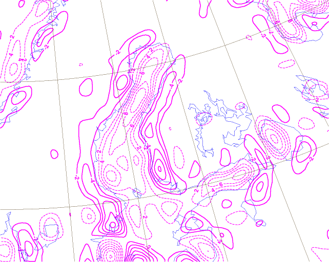
31 May 2001/12.00 UTC - convergence at 1000 hPa, magenta dashed: divergence, magenta solid: convergence
|
|
|
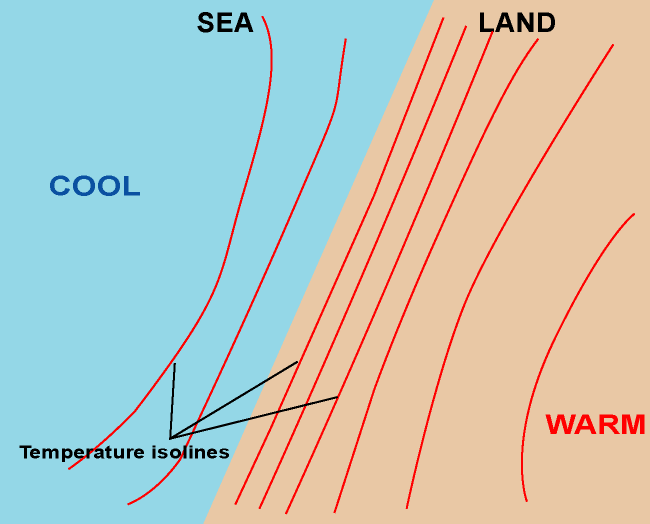
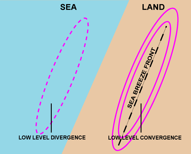
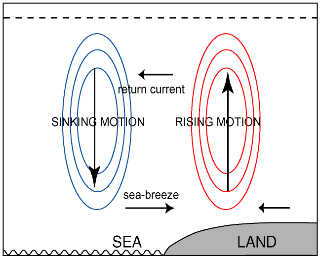
The classical explanation of Sea Breeze is the heated and expanding air over land, causing convergence aloft over land at first, pressure falling over land and divergent spreading out towards the sea ( offshore), then descending air over sea, pressure rising, onshore winds at the surface with low level divergence over sea and low level convergence again at the Sea-Breeze front over land where the cooler air meets the warm air. This scheme is depicted in the image above, top left.
Sea-Breeze and sensible heat flux over sea and land
A study was done by using a 2D mesoscale model to calculate the maximum sensible heat flux on a specific day and a relation was found with the strength of the Sea-Breeze : Um = 0.35 H1/2max. (Um = max Sea-Breeze, perpendicular to the coastline; H1/2max = max sensible heat flux). The start of the Sea-Breeze is of course dependant on the strength of the existing and opposite surface wind Ug. A relation was found between Um and Ug called the Sea-Breeze index : Isb = Ug/Um, and with Im < 1 a high probability exist for the onset of the Sea-Breeze.
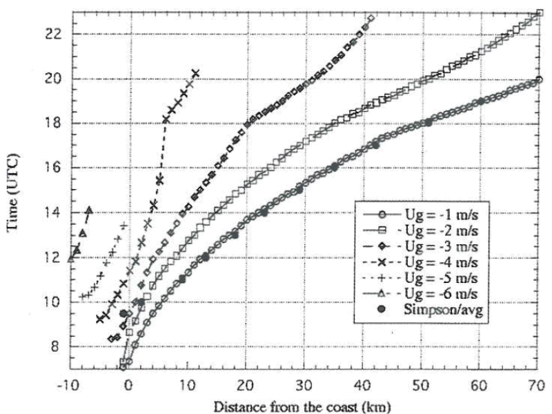
A second and important relation ( X = ts (µm Um - µg Ug) was found by comparing the Sea-Breeze and the opposite wind for the calculation of the distance (X), the Sea Breeze can travel inland given a specific opposite wind. (ts = time, µm and µg are coefficients = 0.7 and 0.8). An explanation of the graphs is available in the chapter Weather Events.
|
Inland penetration of Sea-Breeze front in relation to opposite wind
|
|
|
Typical Appearance In Vertical Cross Sections
In vertical cross-sections the convergence caused by opposing surface/low-level winds at the Sea-breeze front is normally restricted to the lowest kilometre of the atmosphere.
- Low-level convergence:
At the boundary of the Sea-Breeze low-level convergence exists, but coarse model resolution may not always show this properly. - Vertical motion:
Rising motion enhanced by convergence at the Sea-breeze boundary
Low-level convergence
|
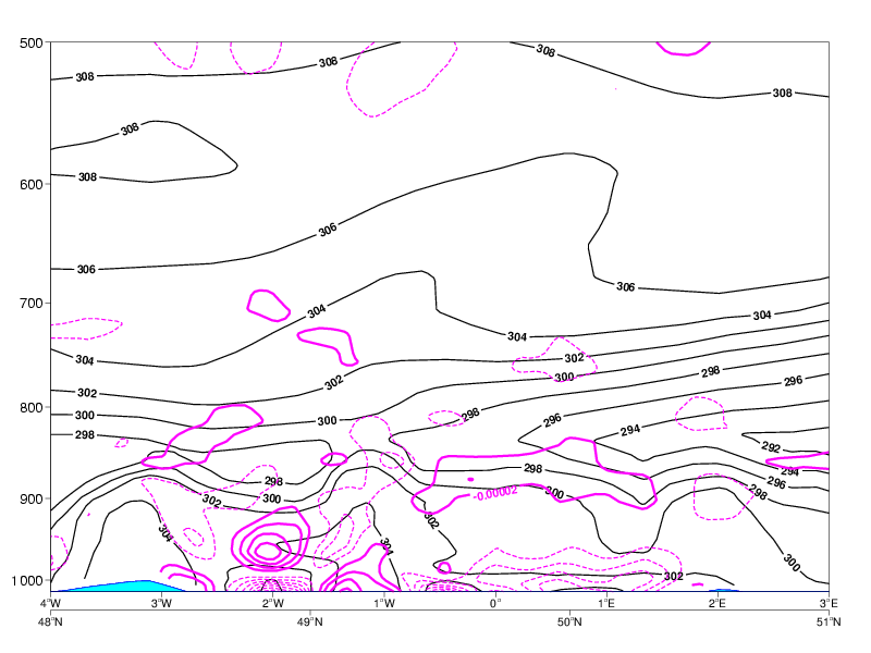
22 April 2009/14.00 UTC - Meteosat HRV image; position of vertical cross section indicated
|
22 April 2009/12.00 UTC - Vertical cross section; magenta dashed: divergence, magenta solid: convergence
|
|
|
|
|
|
|
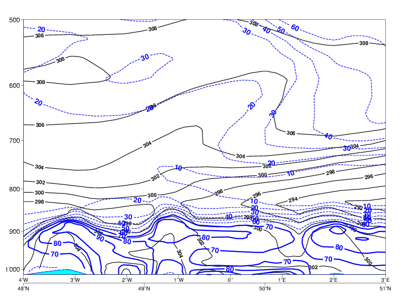
22 April 2009/12.00 UTC - Vertical Cross section; blue: relative humidity
|
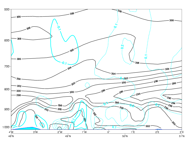
From the theory convergence is to be expected in a See-Breeze situation over land and divergence over sea. Normandy has coordinates around 01.5° W. Convergence is forecast in that area with divergence above. To the east, over the Seine - Bay and west, over the Channel Islands, divergence is forecast with convergence aloft.
With this pattern in mind upward motions have to be present over Normandy with downward motion to the east and west. This pattern is well forecast in the images below with on the left side the expected and theoretical scheme of vertical motion and on the right side the calculated values of up - and downdrafts. The satellite image clearly shows the convective clouds over Normandy and the cloud free area's to the west and east.
Although not a key parameter on its self a vertical cross section on Relative Humidity is plotted on the right side of the Div./Conv - scheme. with RH = 80% or more over Normandy.
|
|
22 April 2009/12.00 UTC - Vertical cross section; cyan solid: vertical motion (omega) - upward motion, cyan dashed: vertical
motion (omega) - downward motion
|
|
|
Weather Events
| Parameter | Description |
| Precipitation (incl. thunder) |
|
| Temperature |
|
| Wind (incl. gusts) |
|
| Other relevant information |
|
|
|
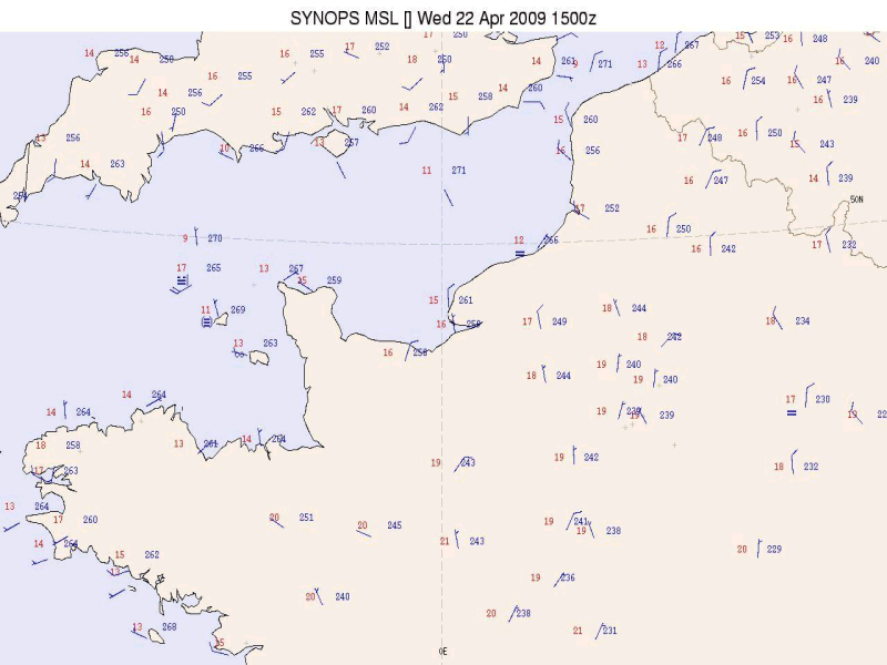
22 April 2009/15.00 UTC - Synoptic plot of Sea-Breeze over Normandy, France
|
|
|
A first example above is the synoptic plot of the Sea-Breeze situation of April 22nd at 15.00UTC over Normandy (see chapter 'cloud structure'). In a flat pressure distribution the onshore surface wind is changing with the coastline: from northeast at the east coast to north at the north coast and northwest to west at the west coast. Over sea and in coastal districts temperatures are around 13 to 15°C, at the same time over land maximum values were found around 20°C.
A second example is the situation of the 3rd of August 2009 over The Netherlands, some images are already available in the chapter cloud structures.
|
03 August 2009/12.00 UTC - Meteosat 9 image HRV/IR 10.8 image
|
03 August 2009/12.00 UTC - Meteorogram Schiphol/Amsterdam
|
|
|
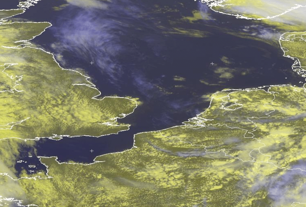
For a recall : in the image left several Sea-Breeze fronts can be located over the north west part of France (near Calais) and over The Netherlands.
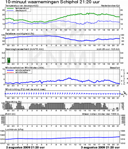
The meteorogram consists of 24 hours graphs of different meteorological variables, measured at the surface and averaged over a period of 10
minutes. The variables are, from top to bottom : temperature and dew point, humidity (RH), precipitation, wind speed and wind direction (blue
arrows), cloudiness, visibility (below 1000m only) and pressure.
In the meteorogram, above right, the recorded values at the aerodrome Amsterdam Airport Schiphol, which is located about 15km to the east of
the Dutch west coast, are depicted. The meteorogram starts at the 2nd of August, 21.20 UTC and last untill the 3rd of August 21.20 UTC. Notice
the small drop in temperature between 13.00 and 14.00 UTC at the time of the veering surface wind, together with the small increase in RH: the
passing of the Sea-Breeze front.
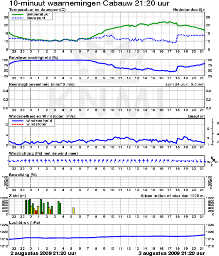
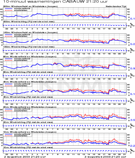
Down below a meteorogram of a KNMI observation site at Cabauw (located in the central part of The Netherlands at a distance of about 55km to the east of the coastline). Left the recorded surface observations (as in the previous meteorogram), right the recorded wind observations (speed, gust in red and wind direction, the blue arrows) at different heights in the 200m tower. The different heights are 10m , 20m, 40m, 80m, 140m and 200m. The passing of the Sea-Breeze front is nicely depicted by a remarkable veering of the wind almost at the same time at all levels.
|
03 August 2009 - Meteorogram Cabauw 022120 - 032120 UTC SFC Observations
|
03 August 2009 - Meteorogram Cabauw 022120 - 032120 UTC Wind observations 200m tower
|
|
|
This Sea-Breeze front moved rather quickly from the coast eastwards with a speed around 8km/hr, reaching the Cabauw observation site by 18.00 UTC.
References
- ANJOS, M. & LOPES, A. (2018): Sea breeze front identification on the northeastern coast of Brazil and its implications for meteorological conditions in the Sergipe region, Theor Appl Climatology, pp 1-15, https://doi.org/10.1007/s00704-018-2732-x
- ATKINS, N.T., WAKIMOTO, R.M. (1997): Influence of the Synoptic-Scale Flow on Sea Breezes Observed during CaPE. Monthly Weather Review, Vol. 125, pp. 2112-2130.
- BADER M. J., FORBES G. S., GRANT J. R., LILLEY R. B. E. and WATERS A. J. (1995): Images in weather forecasting - A practical guide for interpreting satellite and radar imagery. Cambridge University Press.
- KARLSSON, K.- G. (1997): Remote Sensing in Meteorology. Swedish Meteorological and Hydrological Institute.
- PIELKE, R.A. (1981): An overview of our current understanding of the physical interactions between the sea- and land-breeze and the coastal waters. Amsterdam, Ocean Manage., Vol. 6, p. 87-100.
- TIJM, A.B.C., HOLTSLAG, A.A.M., VAN DELDEN, A.J (1999): Observations and Modeling of the Sea Breeze with the Return Current. Monthly Weather Review, Vol. 127, pp. 625-640.
- TIJM, A.B.C (1999): Sea-breeze Studies. Universal Press, Veenendaal.
- WAKIMOTO, R.M., ATKINS, N.T. (1994): Observations of the Sea-Breeze Front during CaPE. Part I: Single-Doppler, Satellite, and Cloud Photogrammetry Analysis. Monthly Weather Review, Vol. 122, pp. 1092-1114.