Table of Contents
Cloud Structure In Satellite Images
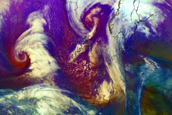
The cloud feature called Instant Occlusion forms when a Comma cloud merges with a frontal cloud band. A comma is situated within an a cold air mass behind the Cold Front, so it is in an unstable environment, which leads to the formation of convective cloudiness. So, the process is one where stratified frontal cloud and convective clouds merge.
Appearance in the basic channels:
The appearance of Instant Occlusion in different channels:
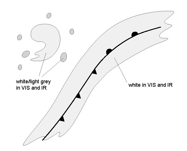
- VIS and IR: In the initial, separate comma stage, the frontal cloud band is white and the Comma cloud and the surrounding convective cloudiness are white to light grey. In the final, merged stage, the whole cloud system is white.
- WV: In the initial stage the Comma cloud is initially light grey to grey, and the frontal cloudiness is white with some light grey structure. In the final stage the whole cloud system is white with some light grey structure.
In the following pictures the initial stage is at the top, the final stage at the bottom.
|

|

|

|
Appearance in the basic RGBs:
Airmass RGB
During the whole instant occlusion development, the cloud systems of both comma and front are embedded with blue to red brown colours representing a very cold and dry air mass descending from the stratosphere behind the Cold Front.
In the initial stage the frontal cloudiness is appears white, while the Comma cloud appears light orange/yellow showing the overflowing dry air, In the final stage the whole cloud system is white.
Dust RGB
Despite from other existing cloud configurations, the Dust RGB shows blue to pinkish blue colours - representing a cloud free area. Very often there are low cloud cells typically in the cold air which shows up in ochre colours, sometimes becoming thicker and therefore dark red.
Usually the comma head - which becomes during the instant occlusion process the spiral of the instant occlusion - is dark red representing thick cloudiness. The comma tail which merges with the former cold front often is much lower showing up with different shades in ochre.
 |
 |
 |
 |
Legend: Schematics for basic RGBs; for two stages of development: comma (upper) and instant occlusion stage (low)Left: airmass RGB; right: dust RGB
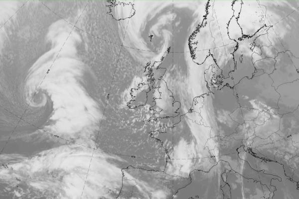
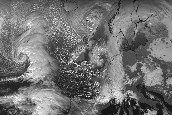
The following sequence of images shows the whole process of an “Instant Occlusion” from the initial stage with a frontal cloud band and a comma configuration in the cold air behind, then into the development stage where the comma is very close to the frontal cloud band. Finally a mature stage is shown, where the former comma forms together with the cloud band a new occlusion spiral.
 |
 |
 |
 |
 |
 |
 |
Legend: 3 hourly sequence from 16 January 2020/21 to 17 January 2020/18 UTC; IR images
*Note: click on the image to access the image gallery (navigate using arrows on keyboard)
The basic images and basic RGBs of the mature stage of an instant occlusion process can be seen below with the example from 17 January 2020 /12 UTC
|
|
|
|
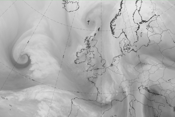

17 January 2020, 12UTC: 1st row: IR (above) + HRV (below); 2nd row: WV (above) + Airmass RGB (below); 3rd row: Dust RGB + image gallery.
*Note: click on the Dust RGB image to access image gallery (navigate using arrows on keyboard)
| IR | Inst. occl. spiral bright; mergence area with CF cloud band dark grey and fibrous. |
| HRV | Inst. occl. spiral bright; mergence area with CF cloud band dark grey. |
| WV | Cold front cloud band light grey indicating high upper level humidity; mergence area and inst. occl. spiral darkgrey. |
| Airmass RGB | Blue colours behind the cold front cloud band indicate cold air; dark brown more to the west shows the cold and dry air; the inst. occl. spiral is overrun by the dry air and therefore is displayed in the image as light brownish colours. |
| Dust RGB | Dark red colours indicate the thick ice cloud in the cold front band as well as in some parts of the inst. occl. spiral; in the mergence area and the largest part of the spiral, the ochre colour represents mid- level cloud. |
Meteorological Physical Background
In the Instant Occlusion process two conceptual models interact, namely a Comma and a Cold Front. The location of the instant occlusion is often the left exit area of a diffluent upper trough.
The Cold Front is connected with a large upper trough. In this trough there is a smaller secondary trough moving faster than the large trough. In the secondary trough there is convective cloud development, a Comma. The development involves the expansion of a cloud cluster into a baroclinic leaf with cyclonic rotation.
Because the smaller trough is moving faster than the large one, Comma overtakes the frontal cloudiness and the two cloud systems merge. Often there is simultaneously going on a wave development within the polar front. The result is a cloud system that resembles an occlusion, but without the actual occlusion process. If the Comma merges with the frontal cloudiness in the area of a Wave, the Occlusion-like feature is very pronounced.
Initial (pre-merging) stage:
- A Cold Front is associated with an eastward moving upper trough.
- In the cold air mass behind the Cold Front, but clearly separated from it, there is a Comma cloud related to a small, sharp trough moving along the edge of the large trough (see Key Parameters).
- There is weak baroclinity related to the Comma; as the cyclonic motion increases, regions of warm and cold advection form ahead and behind the Comma, respectively (see Key Parameters).
Merging stage:
- Positive vorticity advection and warm advection associated to the Comma produce upward motion. This leads to a rapid cloud development, and as the two cloud features simultaneously get nearer each other, they merge.
- The warm advection ahead of the Comma creates a short nook in the temperature field of the frontal zone, but it is remarkably smaller than the ridge that is formed in an occlusion leading to the typical appearance of an occlusion cloud spiral (see Key Parameters).
Discussion: The relative stream point of view
The Initial Stage:
Within and ahead of the Comma an ascending stream of warm and moist air is orientated from southern to northern directions in lower layers. Within the middle and upper levels of the troposphere, dry air moves around the upper level trough overrunning the Comma tail and turning to northern directions parallel to the rear cloud edge of the Cold Front. The vertical stratification of relative stream with warm, moist air and dry air above causes a potential unstable stratification in the shallow moist zone between the two cloud features.

|

|
The Merging Stage:
The potential unstable stratification within the area of the shallow moist zone will now be released due to the developing ascending motion. The ascending motion is caused by the combination of WA and PVA which contributes to upward motion; in particular WA is connected with the Wave feature at the Cold Front. As a consequence of this process rapid cloud development can be observed in the shallow moist zone. Due to WA ahead of the Comma a thermal gradient is generated on its northern side.

Features of relative streams:
- A low level dry outflow from eastern directions appears (developing cold conveyor belt)
- The wet low level stream from south-west no longer exists
- A rising warm conveyor belt accompanying the frontal cloud band
- The dry intrusion strongly rising in the area of the front and the Comma in accordance with the area of cloud development
- A splitting of the dry intrusion close to the Wave point
Final Stage:
In the end of the development the cloud configuration may resemble Cold Conveyor Belt occlusion (see Occlusion: Cold Conveyor Belt Type ), or the part of the cloudiness that resembles an occluded front, can dissolve.
The case studies, however, have shown that the relative stream structure described above can not always be found. More investigations with high resolution model would be needed.
Key Parameters
- Absolute topography at 500 and 1000 hPa:
- Initially a slowly moving large-scale and a faster moving small-scale trough within it.
- At final stage the small-scale trough coincides with a surface low.
- Equivalent thickness and thermal front parameter (TFP):
- The frontal cloud band is associated with high gradient of thickness.
- Initially the Comma is within a weak thickness ridge.
- At final stage there is a thickness gradient with a small nook in the location of the merging of Comma and frontal cloudiness.
- Temperature advection at 700 hPa:
- There is CA behind the Cold Front, and WA ahead of the Warm front. Weaker temperature advections are related to Comma (WA in the leading edge, CA in the tail area).
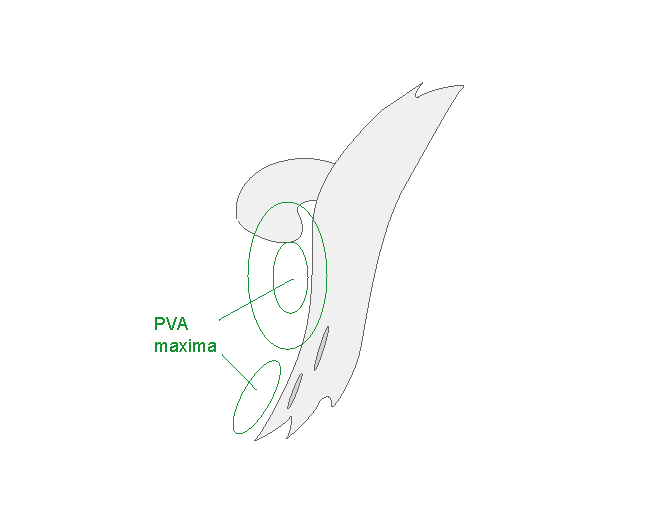
- Vorticity advection at 500 hPa:
- A small, but distinct PVA maximum is in the Comma area, mostly within the comma tail.
- PVA maxima can also be found near the rear edge of the Cold Front cloud band indicating the big upper trough and/or the approach of a jet streak (see Cold Front ).
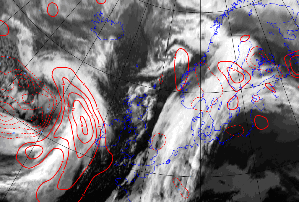
Height contours at 1000 and 500 hPa
| Initial stage |
01 December 2006/12.00 UTC - Meteosat 8 IR 10.8 image; cyan: height 500 hPa; magenta: height 1000 hPa
|

|

|
| Final stage |
02 December 2006/12.00 UTC - Meteosat 8 IR 10.8 image; cyan: height 500 hPa; magenta: height 1000 hPa
|

|

|
Equivalent thickness and TFP
| Initial stage |
01 December 2006/12.00 UTC - Meteosat 8 IR 10.8 image; green: equivalent thickness 500/850 hPa, blue: thermal front parameter 500/850 hPa
|

|

|
| Final stage |
02 December 2006/12.00 UTC - Meteosat 8 IR 10.8 image; green: equivalent thickness 500/850 hPa, blue: thermal front parameter 500/850 hPa
|

|

|
Temperature Advection at 700 hPa
| Initial stage |
01 December 2006/12.00 UTC - Meteosat 8 IR 10.8 image; red solid: warm advection at 700 hPa, red dashed: cold advection 700 hPa
|

|

|
| Final stage |
02 December 2006/12.00 UTC - Meteosat 8 IR 10.8 image; red solid: warm advection at 700 hPa, red dashed: cold advection 700 hPa
|

|
|
Vorticity advection at 500 hPa
| Initial stage |
01 December 2006/12.00 UTC - Meteosat 8 IR 10.8 image; green: Positive Vorticity Advection 500 hPa
|

|

|
| Final stage |
02 December 2006/12.00 UTC - Meteosat 8 IR 10.8 image; green: Positive Vorticity Advection 500 hPa
|
|

|
Typical Appearance In Vertical Cross Sections
- Isentropes:
The typical downward inclined crowding zone with the Cold Front, potentially unstable stratification in the lower troposphere in the Comma area - PVA:
Maxima in the frontal zone increasing with height, a weaker maximum in the comma area. - Divergence:
In the frontal zone convergence on the lower and middle levels, divergence above. In the Comma area convergence on the low layers, divergence on the middle layers. - Omega:
Upward motion in the frontal zone and in the Comma area in lower and middle troposphere.
|
12 January 2007/06.00 UTC - Meteosat IR image; position of vertical cross section indicated
|

|
|
15 January 2007/06.00 UTC - Vertical cross section; black: isentropes
|
|

|

|
|
15 January 2007/06.00 UTC - Vertical cross section; black: isentropes, green: positive vorticity advection
|
|

|

|
|
15 January 2007/06.00 UTC - Vertical cross section; black: isentropes, magenta thick: convergence, magenta thin: divergence
|
|

|

|
|
15 January 2007/06.00 UTC - Vertical cross section; black: isentropes, cyan: upward motion
|
|

|

|
Weather Events
| Parameter | Description |
| Precipitation |
|
| Temperature |
|
| Wind (incl. gusts) |
|
| Other relevant information | - |

|
|
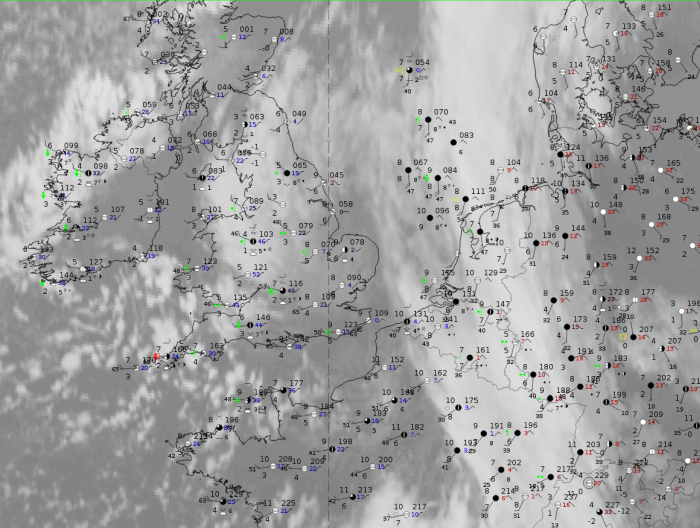
Note: for a larger SYNOP image click this link.
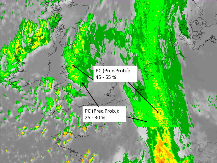
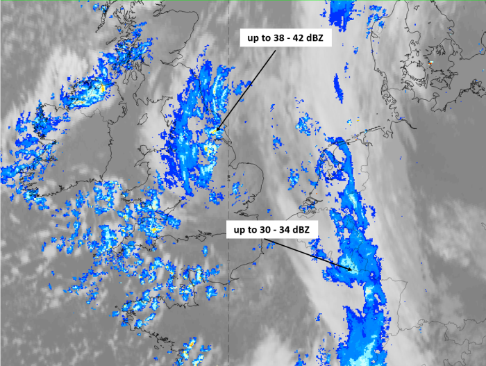
Weather observations of the mature stage of the instant occlusion process on 17 January 2020 at 12 UTC show wide spread precipitation in the instant occlusion spiral over England as well as in the frontal feature over West Europe and Germany with highest intensities in the mergence area. Rain showers appear at the southernmost part of the spiral. Precipitation probabilities are higher than 50% only in a few small regions.
|
|
|
|

Legend:
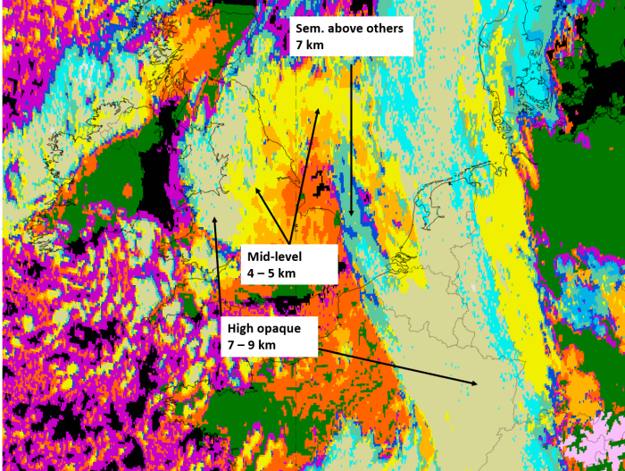
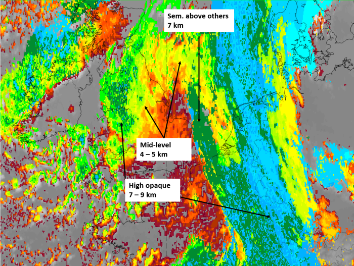
17 January 2020, 12 UTC, IR; superimposed: 1st row: Cloud Type (CT NWCSAF) (above) + Cloud Top Height (CTTH - NWCSAF) (below); 2nd row: Convective Rainfall Rate (CRR NWCSAF) (above) + Radar intensities from Opera radar system (below).
For identifying values for Cloud type (CT), Cloud type height (CTTH), precipitating clouds (PC), and Opera radar for any pixel in the images look into the legends. (link).
References
General Meteorology and Basics
- BARRY, R. G., CARLETON, A. M. (2001): Synoptic and Dynamic Climatology; Routledge
- BROWNING K. A. and HILL F. F. (1985): Mesoscale analysis of a polar trough intersecting with a polar front; Quart.J. R. Meteor. Soc., Vol. 111, p. 445 - 462
- BROWNING K. A. (1985): Conceptual models of precipitation systems; Met. Mag., Vol. 114, p. 293 - 317
- BROWNING K. A. (1986): Conceptual models of precipitation systems; Weather & Forecasting, Vol. 1, p. 23 - 41
- BROWNING K. A. (1990): Organization of clouds and precipitation in extratropical cyclones; in: Extratropical Cyclones, The Erik Palmen Memorial Volume, Ed. Chester Newton and Eero O Holopainen, p. 129 - 153
- CONWAY B. J., GERARD L., LABROUSSE J., LILJAS E., SENESI S., SUNDE J. and ZWATZ-MEISE V. (1996): COST78 Meteorology - Nowcasting, a survey of current knowledge, techniques and practice - Phase 1 report; Office for official publications of the European Communities
- GREEN J. S. A., LUDLAM F. H. and MCILVEEN J. F. R. (1966): Isentropic relative - flow analysis and the parcel theory; Quart. J. R. Meteor. Soc., Vol. 92, p. 210 - 219
- LOCATELLI J. D., HOBBS P. V. and WERTH J. A. (1982): Mesoscale structures of vortices in polar air streams; Mon. Wea. Rev., Vol. 110, p. 1417 - 1433
General Satellite Meteorology
- EVANS M. S., KEYSER D., BOSART L. F. and LACKMANN G. M. (1994): A satellite derived classification scheme for rapid maritime cyclogenesis; Mon. Wea. Rev., Vol. 122, p. 1381 - 1416
- MCGINNIGLE J. B., YOUNG M. V. and BADER M. J. (1988): The development of instant occlusion in the North Atlantic; Met. Mag., Vol 117, p. 325 - 341
- MULLEN S. L. (1983): Explosive cyclogenesis associated with cyclones in polar air streams; Mon. Wea. Rev., Vol. 111, p. 1537 - 1552
- REED R. J. (1979): Cyclogenesis in polar air streams; Mon. Wea. Rev., Vol. 107, p. 38 - 52
- THEPENIER T. M. and CRUETTE D. (1981): Formation of cloud bands associated with the American subtropical jet stream and their interaction with mid-latitude synoptic disturbances reaching Europe; Mon. Wea. Rev., Vol. 109, p. 2209 - 2220